|
Hauerland
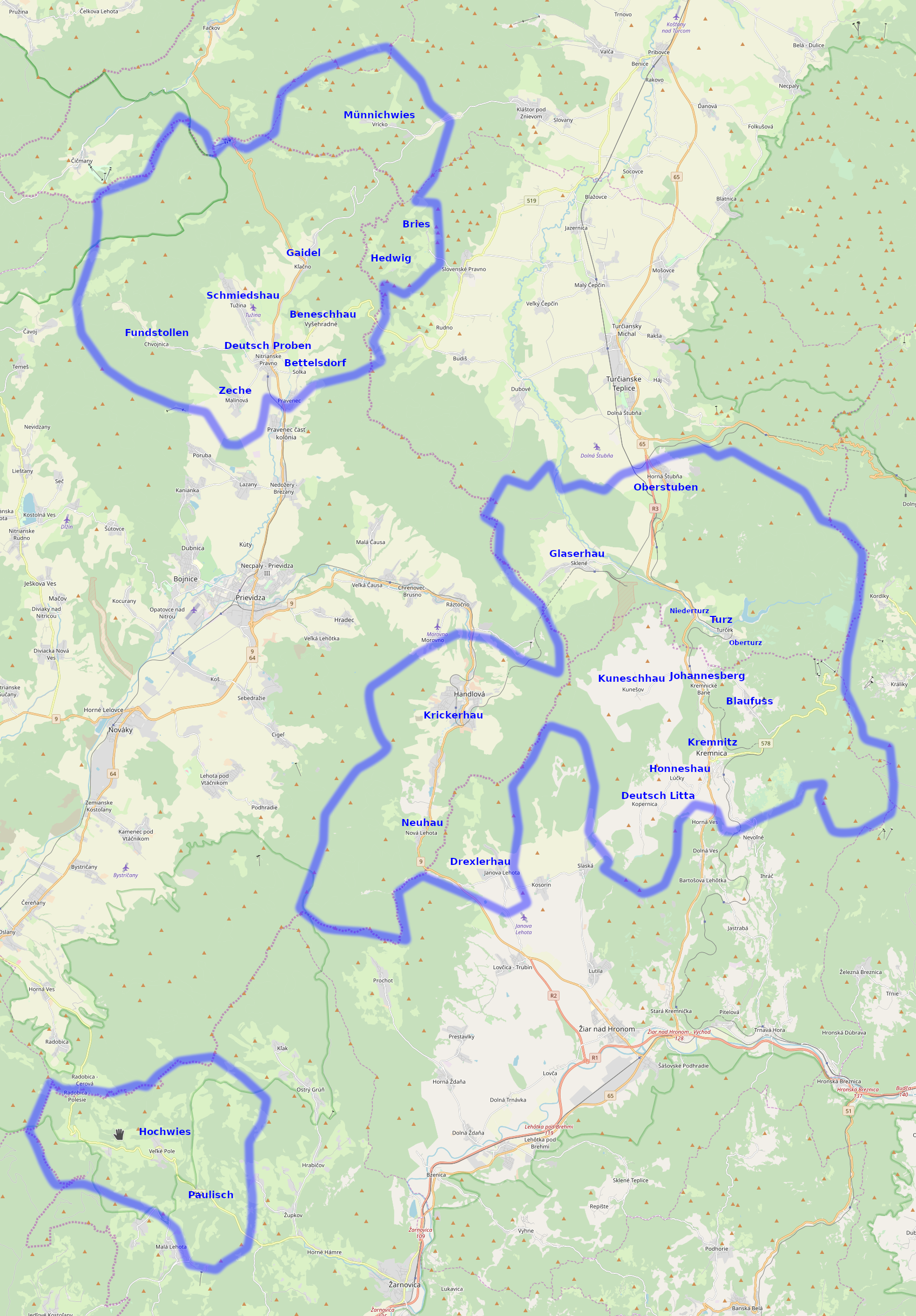
Hauerland (also called ''Kremnitz-Deutschprobener Sprachinsel'') is the German name for a region presently located in central Slovakia once inhabited by Carpathian Germans. Arisen from medieval ''Ostsiedlung'' population movements, it belonged to three German language islands within a greater Slovakian-speaking area. The other two were situated in Bratislava (''Pressburg'') and the Spiš (''Zips'') region. Geography The area laid within the forested Western Carpathians mountain range around the towns of Kremnitz Kremnica (''Kremnitz'') in the south and Nitrianske Pravno (''Deutschproben'') in the north. The term ''Hauerland'' was coined by German folklorists in the 1930s referring to several German placenames in the region bearing the suffix ''-hau'' ("hew (off)", i.e. to clear woodland). Most Hauerland villages are laid out as ''Waldhufendorf'' ("forest village") in areas of forest clearing with the farms arranged in a series along a road or stream. History In the Middle Ages ... [...More Info...] [...Related Items...] OR: [Wikipedia] [Google] [Baidu] |
Carpathian Germans
Carpathian Germans (german: Karpatendeutsche, Mantaken, hu, kárpátnémetek or ''felvidéki németek'', sk, karpatskí Nemci) are a group of ethnic Germans. The term was coined by the historian Raimund Friedrich Kaindl (1866–1930), originally generally referring to the German-speaking population of the area around the Carpathian Mountains: the Cisleithanian (Austrian) crown lands of Galicia and Bukovina, as well as the Hungarian half of the Austro-Hungarian monarchy (including Szepes County), and the northwestern ( Maramuresch) region of Romania. Since the First World War, only the Germans of Slovakia (the Slovak Germans or ''Slowakeideutsche'', including the Zipser Germans) and those of Carpathian Ruthenia in Ukraine have commonly been called ''Carpathian Germans''. Kingdom of Hungary Germans settled in the northern territory of the medieval Kingdom of Hungary (then called Upper Hungary, today mostly Slovakia) from the 12th to the 15th centuries (''see Ostsiedlung''), ... [...More Info...] [...Related Items...] OR: [Wikipedia] [Google] [Baidu] |
Handlová
Handlová (german: Krickerhau, hu, Nyitrabánya, before 1913 ) is a town in the Prievidza District, Trenčín Region in the middle of Slovakia. It is made up of the three parts Handlová, Nová Lehota and Morovno. Geography It is located in the ''Handlovka'' brook valley, surrounded by the mountain ranges of Vtáčnik in the west and Žiar in the south, east and north, in the historical region of Hauerland. It is away from Prievidza and from Žiar nad Hronom. Besides the main settlement, it also has "parts" of Morovno (north-west) and Nová Lehota (south), both annexed 1976. History The town was established in 1376 and was inhabited by German settlers which were later known as the Carpathian Germans. The first known settler in Handlová was Peter Kricker from Kremnica, who came here together with 200 others to establish a settlement on a site called Krásny les (Beautiful Forest). At first the settlers lived just from crops and pastoral farming. Only much later, in the 18th ... [...More Info...] [...Related Items...] OR: [Wikipedia] [Google] [Baidu] |
Slovakia
Slovakia (; sk, Slovensko ), officially the Slovak Republic ( sk, Slovenská republika, links=no ), is a landlocked country in Central Europe. It is bordered by Poland to the north, Ukraine to the east, Hungary to the south, Austria to the southwest, and the Czech Republic to the northwest. Slovakia's mostly mountainous territory spans about , with a population of over 5.4 million. The capital and largest city is Bratislava, while the second largest city is Košice. The Slavs arrived in the territory of present-day Slovakia in the fifth and sixth centuries. In the seventh century, they played a significant role in the creation of Samo's Empire. In the ninth century, they established the Principality of Nitra, which was later conquered by the Principality of Moravia to establish Great Moravia. In the 10th century, after the dissolution of Great Moravia, the territory was integrated into the Principality of Hungary, which then became the Kingdom of Hungary in 1000. In 1241 a ... [...More Info...] [...Related Items...] OR: [Wikipedia] [Google] [Baidu] |
Kunešov
Kunešov (german: Kuneschhau; hu, Kunosvágása) is a village and municipality in Žiar nad Hronom District in the Banská Bystrica Region of central Slovakia Slovakia (; sk, Slovensko ), officially the Slovak Republic ( sk, Slovenská republika, links=no ), is a landlocked country in Central Europe. It is bordered by Poland to the north, Ukraine to the east, Hungary to the south, Austria to the s .... The village once belonged to a German language island but the majority of the German population was expelled in 1945. It still has a German minority (18% according to the 2001 census). References Villages and municipalities in Žiar nad Hronom District {{BanskáBystrica-geo-stub ... [...More Info...] [...Related Items...] OR: [Wikipedia] [Google] [Baidu] |
Upper Hungary
Upper Hungary is the usual English translation of ''Felvidék'' (literally: "Upland"), the Hungarian term for the area that was historically the northern part of the Kingdom of Hungary, now mostly present-day Slovakia. The region has also been called ''Felső-Magyarország'' (literally: "Upper Hungary"; sk, Horné Uhorsko). During the Habsburg–Ottoman wars, Upper Hungary meant only the northeastern parts of the Hungarian Kingdom. The northwestern regions (present-day western and central Slovakia) belonged to ''Lower Hungary''. Sometime during the 18th or 19th century, Upper Hungary began to imply the whole northern regions of the kingdom. The population of Upper Hungary was mixed and mainly consisted of Slovaks, Hungarians, Germans, Ashkenazi Jews and Ruthenians. The first complex demographic data are from the 18th century, in which Slovaks constituted the majority population in Upper Hungary. Slovaks called this territory "''Slovensko''" (Slovakia), which term appears in w ... [...More Info...] [...Related Items...] OR: [Wikipedia] [Google] [Baidu] |
King Of Hungary
The King of Hungary ( hu, magyar király) was the ruling head of state of the Kingdom of Hungary from 1000 (or 1001) to 1918. The style of title "Apostolic King of Hungary" (''Apostoli Magyar Király'') was endorsed by Pope Clement XIII in 1758 and used afterwards by all Monarchs of Hungary. The term "King of Hungary" is typically capitalized only as a title applied to a specific person; however, within this article, the terms "Kings of Hungary" or "Junior Kings" (etc.) are also shown in capital letters, as in the manner of philosophical writing which capitalizes concepts such as Truth, Kindness and Beauty. Establishment of the title Before 1000 AD, Hungary was not recognized as a kingdom and the ruler of Hungary was styled Grand Prince of the Hungarians. The first King of Hungary, Stephen I. was crowned on 25 December 1000 (or 1 January 1001) with the crown Pope Sylvester II had sent him and with the consent of Otto III, Holy Roman Emperor. Following ... [...More Info...] [...Related Items...] OR: [Wikipedia] [Google] [Baidu] |
Charles I Of Hungary
Charles I, also known as Charles Robert ( hu, Károly Róbert; hr, Karlo Robert; sk, Karol Róbert; 128816 July 1342) was King of Hungary and Croatia from 1308 to his death. He was a member of the Capetian House of Anjou and the only son of Charles Martel, Prince of Salerno. His father was the eldest son of Charles II of Naples and Mary of Hungary. Mary laid claim to Hungary after her brother, Ladislaus IV of Hungary, died in 1290, but the Hungarian prelates and lords elected her cousin, Andrew III, king. Instead of abandoning her claim to Hungary, she transferred it to her son, Charles Martel, and after his death in 1295, to her grandson, Charles. On the other hand, her husband, Charles II of Naples, made their third son, Robert, heir to the Kingdom of Naples, thus disinheriting Charles. Charles came to the Kingdom of Hungary upon the invitation of an influential Croatian lord, Paul Šubić, in August 1300. Andrew III died on 14 January 1301, and within four mon ... [...More Info...] [...Related Items...] OR: [Wikipedia] [Google] [Baidu] |
Town Privileges
Town privileges or borough rights were important features of European towns during most of the second millennium. The city law customary in Central Europe probably dates back to Italian models, which in turn were oriented towards the traditions of the self-administration of Roman cities. Judicially, a borough (or burgh) was distinguished from the countryside by means of a charter from the ruling monarch that defined its privileges and laws. Common privileges involved trade (marketplace, the storing of goods, etc.) and the establishment of guilds. Some of these privileges were permanent and could imply that the town obtained the right to be called a borough, hence the term "borough rights" (german: Stadtrecht; nl, stadsrechten). Some degree of self-government, representation by diet, and tax-relief could also be granted. Multiple tiers existed; for example, in Sweden, the basic royal charter establishing a borough enabled trade, but not foreign trade, which required a highe ... [...More Info...] [...Related Items...] OR: [Wikipedia] [Google] [Baidu] |
Sklené, Turčianske Teplice District
Sklené ( en, Sklene; german: Glaserhau; hu, Turócnémeti) is a village and municipality in Turčianske Teplice District in the Žilina Region of northern central Slovakia. History In historical records the village was first mentioned in 1360. Until the end of World War II his village was called Glaserhau and populated mostly by German Catholic farmers who had originally migrated here in the 1400 as gold miners. During the Slovak National Uprising Slovak partisans committed a massacre on 21 September 1944 among the German population of the village, killing 186 inhabitants. Since 1994 a memorial commemorates the victims. Geography The municipality lies at an altitude of 588 metres and covers an area of 40.502 km². It has a population Population typically refers to the number of people in a single area, whether it be a city or town, region, country, continent, or the world. Governments typically quantify the size of the resident population within their jurisdiction ... [...More Info...] [...Related Items...] OR: [Wikipedia] [Google] [Baidu] |
Kremnické Bane
Kremnické Bane (german: Johannesberg; hu, Jánoshegy) is a village and municipality in Žiar nad Hronom District in the Banská Bystrica Region of central Slovakia Slovakia (; sk, Slovensko ), officially the Slovak Republic ( sk, Slovenská republika, links=no ), is a landlocked country in Central Europe. It is bordered by Poland to the north, Ukraine to the east, Hungary to the south, Austria to the s .... The village belonged to a German language island. The German population was expelled in 1945. References Villages and municipalities in Žiar nad Hronom District {{BanskáBystrica-geo-stub ... [...More Info...] [...Related Items...] OR: [Wikipedia] [Google] [Baidu] |


