|
Harzburg
The Harzburg, also called Große Harzburg ("Great Harz Castle"), is a former imperial castle, situated on the northwestern edge of the Harz mountain range overlooking the spa resort of Bad Harzburg in Goslar District in the state of Lower Saxony, Germany. It was erected from 1065 to 1068 at the behest of King Henry IV of Germany, slighted during the Saxon Rebellion in 1073-75, and a century later rebuilt under Emperor Frederick Barbarossa and his Welf successor Otto IV, who died here in 1218. Later used as a robber baron's lair, the hill castle crumbled into ruins over the centuries. Today it has almost completely disappeared; only fragments of the foundation walls and the towers together with the castle well are preserved. Etymology Mentioned as ''Hartesburg'' in a 1071 deed, the name of the castle (german: Burg) is derived from the Harz mountain range, called ''Hart'' in Middle Low German, and is probably affiliated with ''hardt'' meaning "mountain forest". Therefore ... [...More Info...] [...Related Items...] OR: [Wikipedia] [Google] [Baidu] |
Bad Harzburg
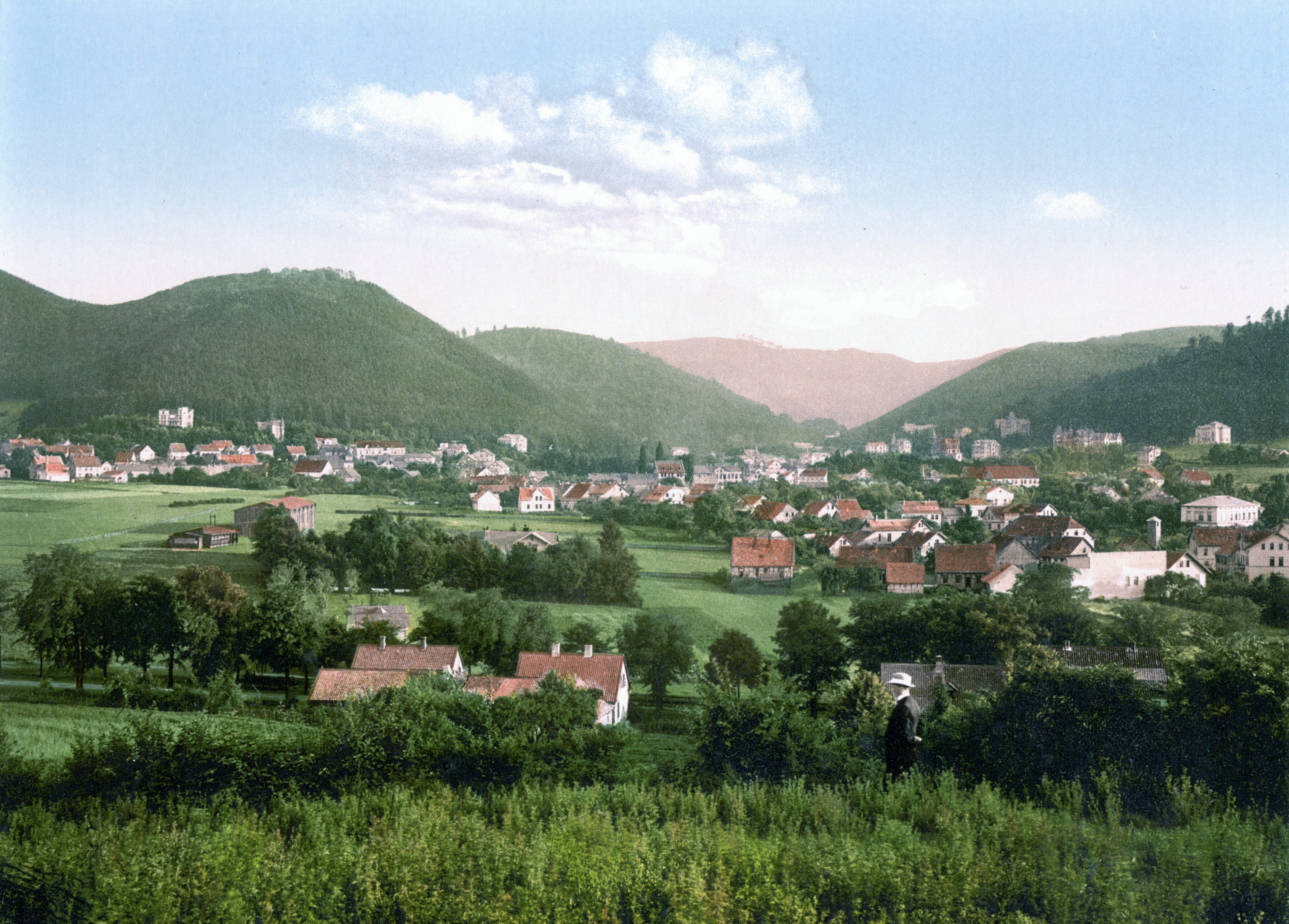
Bad Harzburg (; Eastphalian: ''Bad Harzborch'') is a spa town in central Germany, in the Goslar district of Lower Saxony. It lies on the northern edge of the Harz mountains and is a recognised saltwater spa and climatic health resort. Geography Bad Harzburg is situated at the northern foot of the Harz mountain range on the edge of the Harz National Park. To the east of the borough is the boundary between the states of Lower Saxony and Saxony-Anhalt, the former Inner German Border. The small '' Radau'' river, a tributary to the Oker, has its source in the Harz mountains and flows through the town. Nearby are the towns of Goslar to the west, Vienenburg to the north, Braunlage to the south and Ilsenburg and Osterwieck in the east. Bad Harzburg is rich in natural resources such as gabbro, chalk, gravel, and oolithic iron ore (former Hansa Pit), all of which are or were mined in today's city's area. Climatically Bad Harzburg is a transition zone to a pure alpine region with ... [...More Info...] [...Related Items...] OR: [Wikipedia] [Google] [Baidu] |
Burgberg Cable Car
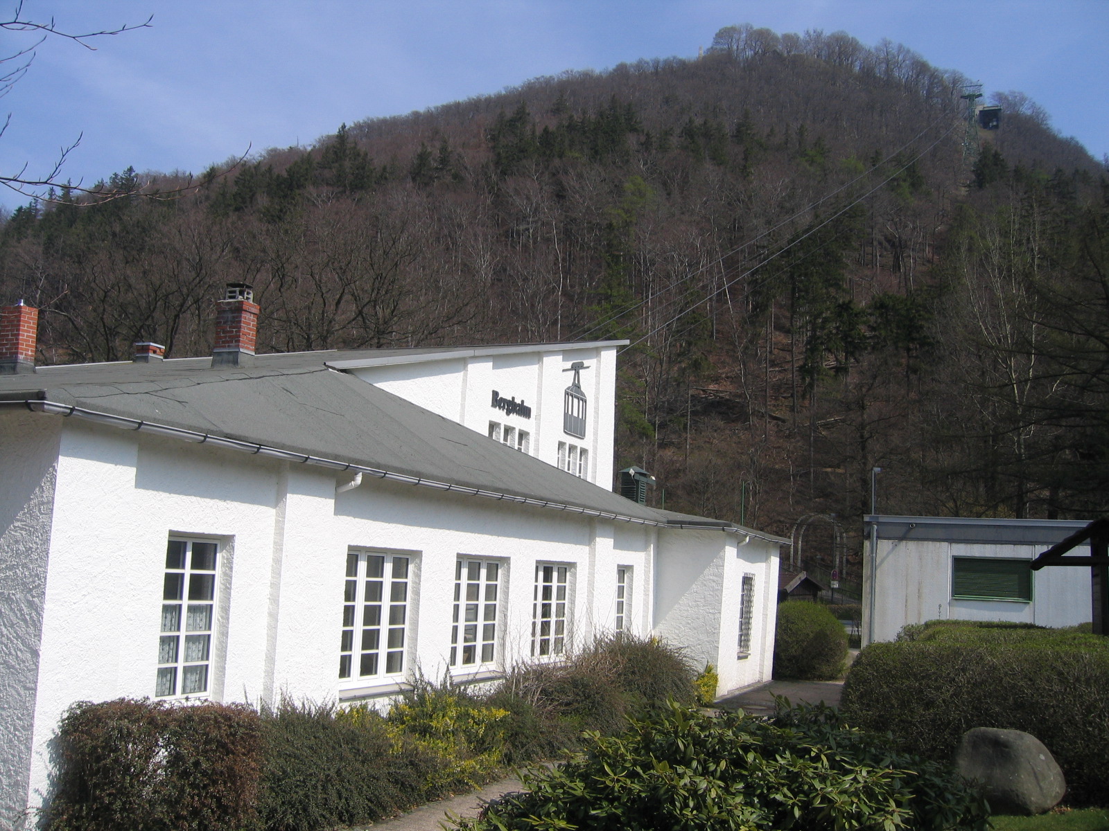
The Burgberg Cable Car (german: Burgbergseilbahn) is a cable car in Bad Harzburg, Germany. It was built in 1929 by the Bleichert Bleichert, short for Adolf Bleichert & Co., was a German engineering firm founded in 1874 by Adolf Bleichert. The company dominated the aerial wire ropeway industry during the first half of the 20th century, and its portfolio included cranes, el ... engineering corporation and has a length of 481 metres. Its hauling cable has a diameter of 18 mm, its carrying cable a diameter of 37 mm. It is driven by a engine at the summit station. It has two cabins carrying up to 18 passengers each. The cable car is named after the Burgberg mountain, site of the historic Harzburg Castle, built by Emperor Henry IV about 1068. The upper terminus was erected next to the ruins. Cable car and stations are preserved in their original 1920s condition. The large gondolas transport passengers in three minutes to the Großer Burgberg (483 m). From there, the ... [...More Info...] [...Related Items...] OR: [Wikipedia] [Google] [Baidu] |
Großer Burgberg
The Großer Burgberg is a ca. high hill on the northern rim of the Harz mountains range, right on the edge of Bad Harzburg in Lower Saxony. Geography It is situated east of the valley of the Radau River, where it leaves the Harz range and flows through the northern foothills towards its confluence with the Oker. The southern outskirts of Bad Harzburg reach up to the foot of the forested slopes. North of the Großer Burgberg summit is the Kleiner Burgberg spur at . Both peaks offer sweeping views over the town and the Northern Lowland. On the Burgberg plateau are foundations of medieval Harzburg Castle and the Canossa Column at , erected in 1877 in the honour of Chancellor Otto von Bismarck. Since 1929 the Burgberg Cable Car The Burgberg Cable Car (german: Burgbergseilbahn) is a cable car in Bad Harzburg, Germany. It was built in 1929 by the Bleichert engineering corporation and has a length of 481 metres. Its hauling cable has a diameter of 18 mm, its carryin ... runs ... [...More Info...] [...Related Items...] OR: [Wikipedia] [Google] [Baidu] |
Harz
The Harz () is a highland area in northern Germany. It has the highest elevations for that region, and its rugged terrain extends across parts of Lower Saxony, Saxony-Anhalt, and Thuringia. The name ''Harz'' derives from the Middle High German word ''Hardt'' or ''Hart'' (hill forest). The name ''Hercynia'' derives from a Celtic name and could refer to other mountain forests, but has also been applied to the geology of the Harz. The Brocken is the highest summit in the Harz with an elevation of above sea level. The Wurmberg () is the highest peak located entirely within the state of Lower Saxony. Geography Location and extent The Harz has a length of , stretching from the town of Seesen in the northwest to Eisleben in the east, and a width of . It occupies an area of , and is divided into the Upper Harz (''Oberharz'') in the northwest, which is up to 800 m high, apart from the 1,100 m high Brocken massif, and the Lower Harz (''Unterharz'') in the east which is up to aro ... [...More Info...] [...Related Items...] OR: [Wikipedia] [Google] [Baidu] |
Radau (river)
Radau is a river of Lower Saxony, Germany. It is right tributary of the Oker. It rises in the Harz range, leaves the mountains at Bad Harzburg, and discharges into the Oker near Vienenburg. Course The river rises at around in the Upper Harz region, in a bog known as ''Torfhausmoor'' or ''Radaubornmoor''. The raised bog stretches from Torfhaus, a hamlet belonging to the Clausthal-Zellerfeld municipality, to the Brocken massif in the east. The historic peat cutting area today is part of the Harz National Park and can be reached via the scenic trail Goethe Way. From its source, the mountain stream flows northwards through the Radau valley that it has carved out and feeds the high waterfall ''Radauwasserfall'' south of Bad Harzburg, immediately next to the Bundesstraße 4 federal highway. The artificial waterfall was constructed as a tourist attraction in 1859 on behalf of the Duchy of Brunswick State Railway company, which had operated the Brunswick–Bad Harzburg railway l ... [...More Info...] [...Related Items...] OR: [Wikipedia] [Google] [Baidu] |
Krodo
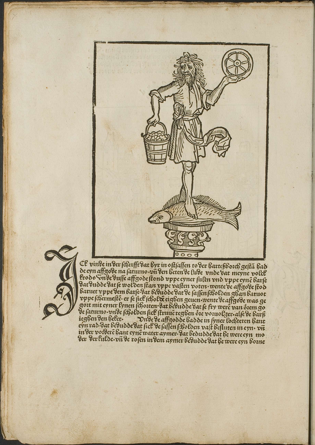
Krodo according to the 1492 ''Saxon Chronicle'' incunable, probably written by the Brunswick goldsmith Conrad Bothe (c. 1475 – c. 1501) and printed in the studio of Peter Schöffer at Mainz, was a Germanic god of the Saxons. He is supposed to have been similar to the Roman god Saturn. Modern historians characterize the figure of Krodo as a fake (Janzen 2017). Description The ''Saxon Chronicle'' (written in Middle Low German: ''Cronecken der Sassen'') contains a fanciful illustration of Krodo as a man clad in a linen garment with a wafting belt, who is standing on a large fish (a bass or perch) holding a bucket of roses in his right hand and an upright wheel in his left. The symbols possibly refer to the ancient four elements, though numerous further attempts at an interpretation have been given. According to Bothe, Julius Caesar during the conquests of ''Magna Germania'' ordered the erection of several fortresses crowned by statues of Roman deities; one of them was de ... [...More Info...] [...Related Items...] OR: [Wikipedia] [Google] [Baidu] |
Goslar (district)
Goslar () is a district in Lower Saxony, Germany. It is bounded by (from the south and clockwise) the districts of Göttingen, Northeim, Hildesheim and Wolfenbüttel, the city of Salzgitter, and by the states of Saxony-Anhalt (district of Harz) and Thuringia ( Nordhausen). History The history of the district is linked with the city of Goslar. The district of Goslar was established in the 19th century by the Prussian government. The city of Goslar did not belong to the district until 1972, when it was eventually incorporated into the district. Langelsheim merged 1 November 2021 with the three municipalities of the Samtgemeinde Lutter am Barenberge, which was abolished. Geography The region comprises the northwestern part of the Harz mountains. The Harz National Park is part of this district. The highest peak is the Wurmberg (971 m) near Braunlage, also being the highest elevation of Lower Saxony. Above the small town of Altenau there is the source of the Oker river, which run ... [...More Info...] [...Related Items...] OR: [Wikipedia] [Google] [Baidu] |
Saxon Rebellion
The Saxon Rebellion or Rebellion of the Saxons (german: Sachsenkrieg), also commonly called the Saxon Uprising (not to be confused with the Saxon Wars, also called the Saxon Uprising), refers to the struggle between the Salian dynasty ruling the Holy Roman Empire and the rebel Saxons during the reign of Henry IV. The conflict reached its climax in the period from summer 1073 until the end of 1075, in a rebellion that involved several clashes of arms. Origins Undercurrents of discord between the Salian royal family and the Saxons already existed under Henry's father, Emperor Henry III. This may have been primarily due to his Rhenish Franconian origin as well as his numerous stays in the Imperial Palace of Goslar, which were associated with a disproportionately high economic burden on the surrounding population. With the accession of Henry IV in 1065 this conflict intensified, as Henry made demands on numerous Imperial domains (''Reichsgüter'') in the centre of the Saxon heartla ... [...More Info...] [...Related Items...] OR: [Wikipedia] [Google] [Baidu] |
Henry IV, Holy Roman Emperor
Henry IV (german: Heinrich IV; 11 November 1050 – 7 August 1106) was Holy Roman Emperor from 1084 to 1105, King of Germany from 1054 to 1105, King of Italy and Burgundy from 1056 to 1105, and Duke of Bavaria from 1052 to 1054. He was the son of Henry III, Holy Roman Emperor—the second monarch of the Salian dynasty—and Agnes of Poitou. After his father's death on 5 October 1056, Henry was placed under his mother's guardianship. She made grants to German aristocrats to secure their support. Unlike her late husband, she could not control the election of the popes, thus the idea of the "liberty of the Church" strengthened during her rule. Taking advantage of her weakness, Archbishop Anno II of Cologne kidnapped Henry in April 1062. He administered Germany until Henry came of age in 1065. Henry endeavoured to recover the royal estates that had been lost during his minority. He employed low-ranking officials to carry out his new policies, causing discontent in Saxony and ... [...More Info...] [...Related Items...] OR: [Wikipedia] [Google] [Baidu] |
Brocken
The Brocken, also sometimes referred to as the Blocksberg, is the highest peak in the Harz mountain range and also the highest peak in Northern Germany; it is near Schierke in the German state of Saxony-Anhalt between the rivers Weser and Elbe. Although its elevation of is below alpine dimensions, its microclimate resembles that of mountains of about . The peak above the tree line tends to have a snow cover from September to May, and mists and fogs shroud it up to 300 days of the year. The mean annual temperature is only . It is the easternmost mountain in northern Germany; travelling east in a straight line, the next prominent elevation would be in the Ural Mountains in Russia. The Brocken has always played a role in legends and has been connected with witches and devils; Johann Wolfgang von Goethe took up the legends in his play ''Faust''. The Brocken spectre is a common phenomenon on this misty mountain, where a climber's shadow cast upon fog creates eerie optical ef ... [...More Info...] [...Related Items...] OR: [Wikipedia] [Google] [Baidu] |
Sachsenbrunnen
The Sachsenbrunnen is an enclosed spring at the ''Säperstelle'' near Bad Harzburg in the Harz Mountains of Germany. It is located on the Emperor Way (''Kaiserweg'') south of the spa town. From here drinking water was piped to castle of Harzburg over several hundred metres of clay tubes in the Middle Ages and Early Modern Period. The ''Säperstelle'' is checkpoint no. 121 in the Harzer Wandernadel The Harzer Wandernadel is a system of hiking awards in the Harz mountains in central Germany. The hiker (or mountain biker) can earn awards at different levels of challenge by walking to the various checkpoints in the network and stamping his or ... hiking network. Bad Harzburg Springs of Germany Landforms of Lower Saxony SSachsenbrunnen {{Goslar-geo-stub ... [...More Info...] [...Related Items...] OR: [Wikipedia] [Google] [Baidu] |
Otto IV, Holy Roman Emperor
Otto IV (1175 – 19 May 1218) was the Holy Roman Emperor from 1209 until his death in 1218. Otto spent most of his early life in England and France. He was a follower of his uncle Richard the Lionheart, who made him Count of Poitou in 1196. With Richard's support, he was elected King of Germany by one faction in a disputed election in 1198, sparking ten years of civil war. The death of his rival, Philip of Swabia, in 1208 left him sole king of Germany. In 1209, Otto marched to Italy to be crowned emperor by Pope Innocent III. In 1210, he sought to unite the Kingdom of Sicily with the Empire, breaking with Innocent, who excommunicated him. He allied with England against France and took part in the alliance's defeat at Bouvines in 1214. He was abandoned by most of his supporters in 1215 and lived the rest of his life in retirement on his estates near Brunswick. He was the only German king of the Welf dynasty. Career Early life Otto was the third son of Henry the Lion, ... [...More Info...] [...Related Items...] OR: [Wikipedia] [Google] [Baidu] |


