|
HMS Swan (1767)
HMS ''Swan'' was launched on 21 November 1767 at Plymouth as the lead ship of the 24 ships in the 14-gun ''Swan''-class of ship-sloops built in the 1760s and 1770s. She served during the American Revolutionary War and the French Revolutionary War. She bore the name HMS ''Explosion'' between 1779 and 1783; at the time she was classed as a fireship. She was laid up in 1801 and finally sold in 1814. ''Swan'' then became a whaler in the Whaling in the United Kingdom#The northern whale fishery, northern whale fishery, sailing out of Kingston-on-Hull. She also made one voyage to the Whaling in the United Kingdom#The southern whale fishery, southern whale fishery (1819–1821) and one merchant voyage to Brazil and Hamburg, before returning to the northern whale fishery. She was ship breaking, broken up circa. 1841. Royal Navy December, 1774 under command of Capt. James Ayscough serving in British North America. ''Swan'' took ''Europe'' and sent her to Cowes around 17 July 1793. Whal ... [...More Info...] [...Related Items...] OR: [Wikipedia] [Google] [Baidu] |
Plymouth Dockyard
His Majesty's Naval Base, Devonport (HMNB Devonport) is one of three operating bases in the United Kingdom for the Royal Navy (the others being HMNB Clyde and HMNB Portsmouth) and is the sole nuclear repair and refuelling facility for the Royal Navy. The largest naval base in Western Europe, HMNB Devonport is located in Devonport, in the west of the city of Plymouth, England. The base began as Royal Navy Dockyard in the late 17th century, but shipbuilding ceased at Devonport in the early 1970s, although ship maintenance work has continued. The now privatised maintenance facilities are operated by Babcock International Group, who took over the previous owner Devonport Management Limited (DML) in 2007. DML had been running the Dockyard since privatisation in 1987. From 1934 until the early 21st century the naval barracks on the site was named HMS ''Drake'' (it had previously been known as HMS ''Vivid'' after the base ship of the same name). The name HMS ''Drake'' and its c ... [...More Info...] [...Related Items...] OR: [Wikipedia] [Google] [Baidu] |
Tun (unit)
The tun ( ang, tunne, la, tunellus, ) is an English unit of ''liquid volume'' (not weight), used for measuring wine, oil or honey. Typically a large vat or vessel, most often holding 252 wine gallons, but occasionally other sizes (e.g. 256, 240 and 208 gallons) were also used. The modern tun is about 954 litres. The word ''tun'' is etymologically related to the word ''ton'' for the unit of mass, the mass of a tun of wine being approximately one long ton, which is . History Originally, the tun was defined as 256 wine gallons; this is the basis for the name of the quarter of 64 corn gallons. At some time before the 15th century, it was reduced to 252 gallons, so as to be evenly divisible by other small integers, including seven.252 = In one Early Modern English example from 1507, a tun is defined as 240 gallons. With the adoption of the Queen Anne wine gallon of 231 cubic inches in 1706 the tun approximated the volume of a cylinder with both dia ... [...More Info...] [...Related Items...] OR: [Wikipedia] [Google] [Baidu] |
1767 Ships
Events January–March * January 1 – The first annual volume of ''The Nautical Almanac and Astronomical Ephemeris'', produced by British Astronomer Royal Nevil Maskelyne at the Royal Observatory, Greenwich, gives navigators the means to find longitude at sea, using tables of lunar distance. * January 9 – William Tryon, governor of the Royal Colony of North Carolina, signs a contract with architect John Hawks to build Tryon Palace, a lavish Georgian style governor's mansion on the New Bern waterfront. * February 16 – On orders from head of state Pasquale Paoli of the newly independent Republic of Corsica, a contingent of about 200 Corsican soldiers begins an invasion of the small island of Capraia off of the coast of northern Italy and territory of the Republic of Genoa. By May 31, the island is conquered as its defenders surrender.George Renwick, ''Romantic Corsica: Wanderings in Napoleon's Isle'' (Charles Scribner's Sons, 1910) p230 * February 19 & ... [...More Info...] [...Related Items...] OR: [Wikipedia] [Google] [Baidu] |
Sloops Of The Royal Navy
A sloop is a sailboat with a single mast typically having only one headsail in front of the mast and one mainsail aft of (behind) the mast. Such an arrangement is called a fore-and-aft rig, and can be rigged as a Bermuda rig with triangular sails fore and aft, or as a gaff-rig with triangular foresail(s) and a gaff rigged mainsail. Sailboats can be classified according to type of rig, and so a sailboat may be a sloop, catboat, cutter, ketch, yawl, or schooner. A sloop usually has only one headsail, although an exception is the Friendship sloop, which is usually gaff-rigged with a bowsprit and multiple headsails. If the vessel has two or more headsails, the term cutter may be used, especially if the mast is stepped further towards the back of the boat. When going before the wind, a sloop may carry a square-rigged topsail which will be hung from a topsail yard and be supported from below by a crossjack. This sail often has a large hollow foot, and this foot is sometimes fil ... [...More Info...] [...Related Items...] OR: [Wikipedia] [Google] [Baidu] |
Disko Island
Disko Island ( kl, Qeqertarsuaq, da, Diskoøen) is a large island in Baffin Bay, off the west coast of Greenland. It has an area of ,Norwegian University of Science and Technology making it the second largest of Greenland after the main island and one of the 100 largest islands in the world. Etymology The name means ''The Large Island'' (from = island).Geography  The island has a length of about , ri ...
[...More Info...] [...Related Items...] OR: [Wikipedia] [Google] [Baidu] |
John Ward - The 'Swan' And 'Isabella' ERY HUMM 2007 1442
John is a common English name and surname: * John (given name) * John (surname) John may also refer to: New Testament Works * Gospel of John, a title often shortened to John * First Epistle of John, often shortened to 1 John * Second Epistle of John, often shortened to 2 John * Third Epistle of John, often shortened to 3 John People * John the Baptist (died c. AD 30), regarded as a prophet and the forerunner of Jesus Christ * John the Apostle (lived c. AD 30), one of the twelve apostles of Jesus * John the Evangelist, assigned author of the Fourth Gospel, once identified with the Apostle * John of Patmos, also known as John the Divine or John the Revelator, the author of the Book of Revelation, once identified with the Apostle * John the Presbyter, a figure either identified with or distinguished from the Apostle, the Evangelist and John of Patmos Other people with the given name Religious figures * John, father of Andrew the Apostle and Saint Peter * Pop ... [...More Info...] [...Related Items...] OR: [Wikipedia] [Google] [Baidu] |
Hamburg
(male), (female) en, Hamburger(s), Hamburgian(s) , timezone1 = Central (CET) , utc_offset1 = +1 , timezone1_DST = Central (CEST) , utc_offset1_DST = +2 , postal_code_type = Postal code(s) , postal_code = 20001–21149, 22001–22769 , area_code_type = Area code(s) , area_code = 040 , registration_plate = , blank_name_sec1 = GRP (nominal) , blank_info_sec1 = €123 billion (2019) , blank1_name_sec1 = GRP per capita , blank1_info_sec1 = €67,000 (2019) , blank1_name_sec2 = HDI (2018) , blank1_info_sec2 = 0.976 · 1st of 16 , iso_code = DE-HH , blank_name_sec2 = NUTS Region , blank_info_sec2 = DE6 , website = , footnotes ... [...More Info...] [...Related Items...] OR: [Wikipedia] [Google] [Baidu] |
Walvis Bay
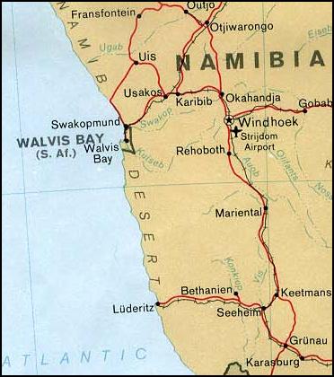
Walvis Bay ( en, lit. Whale Bay; af, Walvisbaai; ger, Walfischbucht or Walfischbai) is a city in Namibia and the name of the bay on which it lies. It is the second largest city in Namibia and the largest coastal city in the country. The city covers a total area of of land. The bay is a safe haven for sea vessels because of its natural deepwater harbour, protected by the Pelican Point sand spit, being the only natural harbour of any size along the country's coast. Being rich in plankton and marine life, these waters also drew large numbers of southern right whales, attracting whalers and fishing vessels. A succession of colonists developed the location and resources of this strategic harbour settlement. The harbour's value in relation to the sea route around the Cape of Good Hope had caught the attention of world powers since it was discovered by the outside world in 1485. This explains the complicated political status of Walvis Bay down the years. The town is situated ... [...More Info...] [...Related Items...] OR: [Wikipedia] [Google] [Baidu] |
Davis Strait
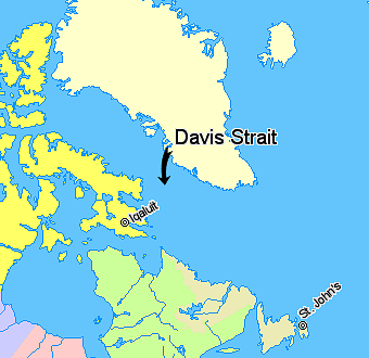
Davis Strait is a northern arm of the Atlantic Ocean that lies north of the Labrador Sea. It lies between mid-western Greenland and Baffin Island in Nunavut, Canada. To the north is Baffin Bay. The strait was named for the English explorer John Davis (1550–1605), who explored the area while seeking a Northwest Passage. By the 1650s it was used for whale hunting. Extent The International Hydrographic Organization defines the limits of the Davis Strait as follows: ''On the North.'' The Southern limit of Baffin Bay 70° North between Greenland and Baffin Island">Baffin Land]. ''On the East.'' The Southwest coast of Greenland. ''On the South.'' The parallel of 60th parallel north, 60° North between Greenland and Labrador. ''On the West.'' The Eastern limit of the Northwestern Passages South of 70° North he East coast of Baffin Island to East Bluff, its Southeastern extremityand of Hudson Strait line from East Bluff, the Southeast extreme of Baffin Island (), to Point ... [...More Info...] [...Related Items...] OR: [Wikipedia] [Google] [Baidu] |
Builder's Old Measurement
Builder's Old Measurement (BOM, bm, OM, and o.m.) is the method used in England from approximately 1650 to 1849 for calculating the cargo capacity of a ship. It is a volumetric measurement of cubic capacity. It estimated the tonnage of a ship based on length and maximum beam (nautical), beam. It is expressed in "tons burden" ( en-em , burthen , enm , byrthen ), and abbreviated "tons bm". The formula is: : \text = \frac where: * ''Length'' is the length, in foot (length), feet, from the stem (ship), stem to the sternpost; * ''Beam (nautical), Beam'' is the maximum beam, in feet. The Builder's Old Measurement formula remained in effect until the advent of steam propulsion. Steamships required a different method of estimating tonnage, because the ratio of length to beam was larger and a significant volume of internal space was used for boilers and machinery. In 1849, the Moorsom System was created in the United Kingdom. The Moorsom system calculates the cargo-carrying capaci ... [...More Info...] [...Related Items...] OR: [Wikipedia] [Google] [Baidu] |


