|
HMS Curacoa (1854)
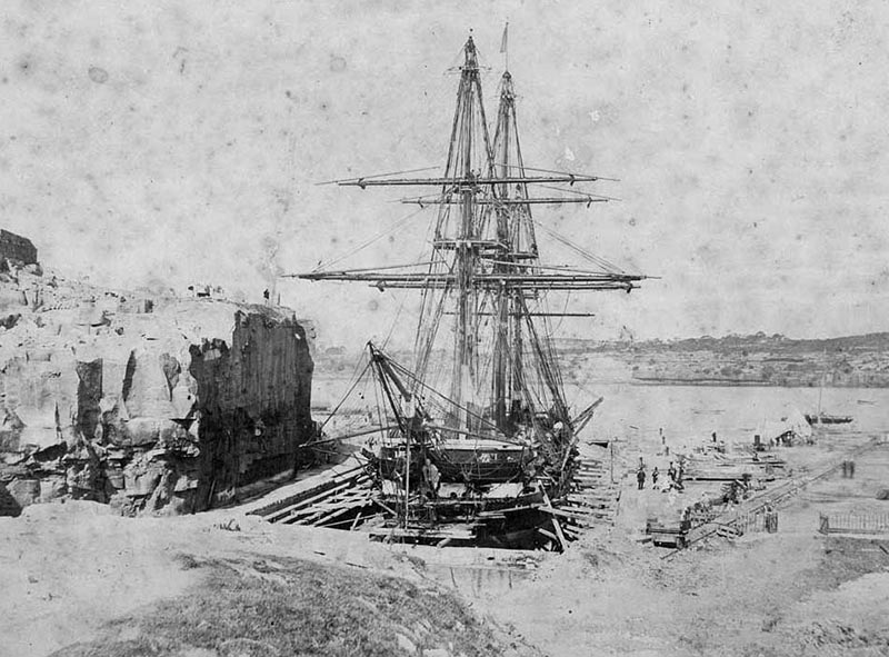
HMS ''Curacoa'' was a 31-gun ''Tribune''-class screw frigate launched on 13 April 1854 from Pembroke Dockyard. She served in the Mediterranean Station between 1854 until 1857 and was in the Black Sea during the Crimean War. She was part of the Channel Squadron between 1857 until 1859. On 24 October 1858, ''Curacoa'' ran aground on the Pelican Reef, off Smyrna, Ottoman Empire. All onboard were rescued. She was refloated on 26 October with assistance from and taken into Smyrna on 28 October. On 4 February 1859, ''Curacoa'' collided with the British merchant ship ''Fleta'' in the English Channel. She then was sent to North America and West Indies Station and served between 1859 until 1862. Afterward, she went to the Australia Station, where she remained until 1866. She was the flagship of the Australia Station from 20 April 1863 until May 1866, having had her armament reduced to 23 guns in 1863. Curacoa Island, off the Queensland coast, is named after HMS Curacoa (1854) Duri ... [...More Info...] [...Related Items...] OR: [Wikipedia] [Google] [Baidu] |
Naval Ensign Of The United Kingdom
The White Ensign, at one time called the St George's Ensign due to the simultaneous existence of a cross-less version of the flag, is an ensign worn on British Royal Navy ships and shore establishments. It consists of a red St George's Cross on a white field, identical to the flag of England except with the Union Flag in the upper canton. The White Ensign is also worn by yachts of members of the Royal Yacht Squadron and by ships of Trinity House escorting the reigning monarch. In addition to the United Kingdom, several other nations have variants of the White Ensign with their own national flags in the canton, with the St George's Cross sometimes being replaced by a naval badge omitting the cross altogether. Yachts of the Royal Irish Yacht Club wear a white ensign with an Irish tricolour in the first quadrant and defaced by the crowned harp from the Heraldic Badge of Ireland. The Flag of the British Antarctic Territory and the Commissioners' flag of the Northern Lighthouse Bo ... [...More Info...] [...Related Items...] OR: [Wikipedia] [Google] [Baidu] |
Flagship
A flagship is a vessel used by the commanding officer of a group of naval ships, characteristically a flag officer entitled by custom to fly a distinguishing flag. Used more loosely, it is the lead ship in a fleet of vessels, typically the first, largest, fastest, most heavily armed, or best known. Over the years, the term "flagship" has become a metaphor used in industries such as broadcasting, automobiles, education, technology, airlines, and retail to refer to their highest profile or most expensive products and locations. Naval use In common naval use, the term ''flagship'' is fundamentally a temporary designation; the flagship is wherever the admiral's flag is being flown. However, admirals have always needed additional facilities, including a meeting room large enough to hold all the captains of the fleet and a place for the admiral's staff to make plans and draw up orders. Historically, only larger ships could accommodate such requirements. The term was also used by ... [...More Info...] [...Related Items...] OR: [Wikipedia] [Google] [Baidu] |
Ships Built In Pembroke Dock
A ship is a large watercraft that travels the world's oceans and other sufficiently deep waterways, carrying cargo or passengers, or in support of specialized missions, such as defense, research, and fishing. Ships are generally distinguished from boats, based on size, shape, load capacity, and purpose. Ships have supported exploration, trade, warfare, migration, colonization, and science. After the 15th century, new crops that had come from and to the Americas via the European seafarers significantly contributed to world population growth. Ship transport is responsible for the largest portion of world commerce. The word ''ship'' has meant, depending on the era and the context, either just a large vessel or specifically a ship-rigged sailing ship with three or more masts, each of which is square-rigged. As of 2016, there were more than 49,000 merchant ships, totaling almost 1.8 billion dead weight tons. Of these 28% were oil tankers, 43% were bulk carriers, and 13% were con ... [...More Info...] [...Related Items...] OR: [Wikipedia] [Google] [Baidu] |
1854 Ships
Events January–March * January 4 – The McDonald Islands are discovered by Captain William McDonald aboard the ''Samarang''. * January 6 – The fictional detective Sherlock Holmes is perhaps born. * January 9 – The Teutonia Männerchor in Pittsburgh, U.S.A. is founded to promote German culture. * January 20 – The North Carolina General Assembly in the United States charters the Atlantic and North Carolina Railroad, to run from Goldsboro through New Bern, to the newly created seaport of Morehead City, near Beaufort. * January 21 – The iron clipper runs aground off the east coast of Ireland, on her maiden voyage out of Liverpool, bound for Australia, with the loss of at least 300 out of 650 on board. * February 11 – Major streets are lit by coal gas for the first time by the San Francisco Gas Company; 86 such lamps are turned on this evening in San Francisco, California. * February 13 – Mexican troops force William Walker and his ... [...More Info...] [...Related Items...] OR: [Wikipedia] [Google] [Baidu] |
European And American Voyages Of Scientific Exploration
The era of European and American voyages of scientific exploration followed the Age of Discovery and were inspired by a new confidence in science and reason that arose in the Age of Enlightenment. Maritime expeditions in the Age of Discovery were a means of expanding colonial empires, establishing new trade routes and extending diplomatic and trade relations to new territories, but with the Enlightenment scientific curiosity became a new motive for exploration to add to the commercial and political ambitions of the past. See also List of Arctic expeditions and List of Antarctic expeditions. Maritime exploration in the Age of Discovery From the early 15th century to the early 17th century the Age of Discovery had, through Spanish and Portuguese seafarers, opened up southern Africa, the Americas (New World), Asia and Oceania to European eyes: Bartholomew Dias had sailed around the Cape of southern Africa in search of a trade route to India; Christopher Columbus, on four journeys ... [...More Info...] [...Related Items...] OR: [Wikipedia] [Google] [Baidu] |
New Zealand
New Zealand ( mi, Aotearoa ) is an island country in the southwestern Pacific Ocean. It consists of two main landmasses—the North Island () and the South Island ()—and over 700 smaller islands. It is the sixth-largest island country by area, covering . New Zealand is about east of Australia across the Tasman Sea and south of the islands of New Caledonia, Fiji, and Tonga. The country's varied topography and sharp mountain peaks, including the Southern Alps, owe much to tectonic uplift and volcanic eruptions. New Zealand's capital city is Wellington, and its most populous city is Auckland. The islands of New Zealand were the last large habitable land to be settled by humans. Between about 1280 and 1350, Polynesians began to settle in the islands and then developed a distinctive Māori culture. In 1642, the Dutch explorer Abel Tasman became the first European to sight and record New Zealand. In 1840, representatives of the United Kingdom and Māori chiefs ... [...More Info...] [...Related Items...] OR: [Wikipedia] [Google] [Baidu] |
Auckland
Auckland (pronounced ) ( mi, Tāmaki Makaurau) is a large metropolitan city in the North Island of New Zealand. The List of New Zealand urban areas by population, most populous urban area in the country and the List of cities in Oceania by population, fifth largest city in Oceania, Auckland has an urban population of about It is located in the greater Auckland Region—the area governed by Auckland Council—which includes outlying rural areas and the islands of the Hauraki Gulf, and which has a total population of . While European New Zealanders, Europeans continue to make up the plurality of Auckland's population, the city became multicultural and Cosmopolitanism, cosmopolitan in the late-20th century, with Asian New Zealanders, Asians accounting for 31% of the city's population in 2018. Auckland has the fourth largest Foreign born, foreign-born population in the world, with 39% of its residents born overseas. With its large population of Pasifika New Zealanders, the city is ... [...More Info...] [...Related Items...] OR: [Wikipedia] [Google] [Baidu] |
Invasion Of Waikato
The Invasion of the Waikato became the largest and most important campaign of the 19th-century New Zealand Wars. Hostilities took place in the North Island of New Zealand between the military forces of the colonial government and a federation of Māori tribes known as the Kingitanga Movement. The Waikato is a territorial region with a northern boundary somewhat south of the present-day city of Auckland. The campaign lasted for nine months, from July 1863 to April 1864. The invasion was aimed at crushing Kingite power (which European settlers saw as a threat to colonial authority) and also at driving Waikato Māori from their territory in readiness for occupation and settlement by European colonists. The campaign was fought by a peak of about 14,000 Imperial and colonial troops and about 4,000 Māori warriors drawn from more than half the major North Island tribal groups. Plans for the invasion were drawn up at the close of the First Taranaki War in 1861 but the Colonial Off ... [...More Info...] [...Related Items...] OR: [Wikipedia] [Google] [Baidu] |
Queensland
) , nickname = Sunshine State , image_map = Queensland in Australia.svg , map_caption = Location of Queensland in Australia , subdivision_type = Country , subdivision_name = Australia , established_title = Before federation , established_date = Colony of Queensland , established_title2 = Separation from New South Wales , established_date2 = 6 June 1859 , established_title3 = Federation , established_date3 = 1 January 1901 , named_for = Queen Victoria , demonym = , capital = Brisbane , largest_city = capital , coordinates = , admin_center_type = Administration , admin_center = 77 local government areas , leader_title1 = Monarch , leader_name1 = Charles III , leader_title2 = Governor , leader_name2 = Jeannette Young , leader_title3 = Premier , leader_name3 = Annastacia Palaszczuk ( ALP) , legislature = Parliament of Queensland , judiciary = Supreme Court of Queensland , national_representation = Parliament of Australia , national_representation_type ... [...More Info...] [...Related Items...] OR: [Wikipedia] [Google] [Baidu] |
Curacoa Island
Curacoa Island (pron. KEWR-ə-sow) is one of the islands in the Palm Islands group off the coast of Queensland, Australia. The nearest island is Great Palm Island, after which the group is named. Curacoa Island is uninhabited. The Aboriginal name for this island is Noogoo Island. Along with nine of the other islands within the Palm Islands group, it falls under the local government area of the Aboriginal Shire of Palm Island. It was named after HMS ''Curacoa'', flagship of the Australia Station from 20 April 1863 until May 1866. The island was gazetted as an Aboriginal reserve on 20 September 1941, along with neighbouring small islands, with the intention of extending Palm Island Aboriginal Settlement Palm Island Aboriginal Settlement, later officially known as Director of Native Affairs Office, Palm Island and also known as Palm Island Aboriginal Reserve, Palm Island mission and Palm Island Dormitory, was an Aboriginal reserve and penal set ..., but it was never used ... [...More Info...] [...Related Items...] OR: [Wikipedia] [Google] [Baidu] |


_p225_AUCKLAND%2C_NEW_ZEALAND.jpg)
