|
Hunshelf
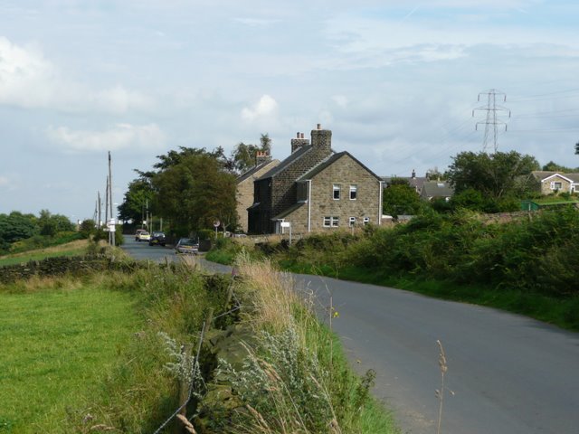
Hunshelf is a civil parish in the Metropolitan Borough of Barnsley. At the 2001 census it had a population of 324, reducing to 246 at the 2011 Census. Most of its population lives in the village of Green Moor. See also *Listed buildings in Hunshelf Hunshelf is a civil parish in the metropolitan borough of Barnsley, South Yorkshire, England. The ward contains 23 Listed building#England and Wales, listed buildings that are recorded in the National Heritage List for England. Of these, one ... References *The town-fields and commons of Hunshelf, Langsett & Waldershelf and how such were alienated from communal to private ownership, Joseph Kenworthy, 1917. Volume 13 of Early history of Stocksbridge and district: Handbook. *History in Hunshelf, chapter in Aspects of Barnsley, Brian Elliot, Wharncliffe Publishing. External links * Civil parishes in South Yorkshire Geography of the Metropolitan Borough of Barnsley {{SouthYorkshire-geo-stub ... [...More Info...] [...Related Items...] OR: [Wikipedia] [Google] [Baidu] |
Listed Buildings In Hunshelf
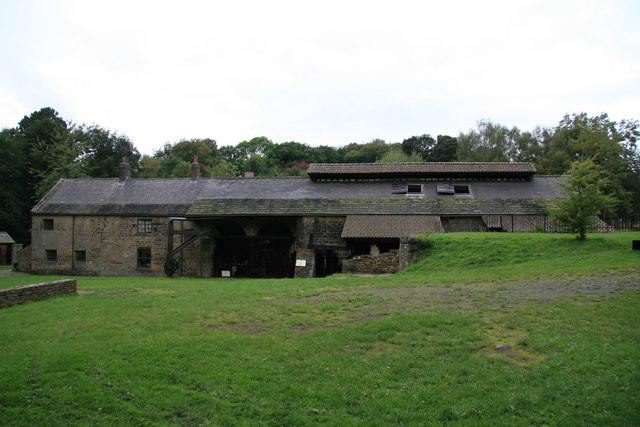
Hunshelf is a civil parish in the metropolitan borough of Barnsley, South Yorkshire, England. The ward contains 23 listed buildings that are recorded in the National Heritage List for England. Of these, one is listed at Grade I, the highest of the three grades, and the others are at Grade II, the lowest grade. Apart from the hamlet of Green Moor, the parish is entirely rural. There are remnants of its industrial past in Wortley Top Forge, which is "one of only three water-powered hammer forges surviving in the United Kingdom". This is listed together with associated buildings. Most of the other listed buildings in the parish are farmhouses, farm buildings, and associated structures. The rest of the listed buildings consist of a guide post, a deer paddock, three bridges, and a set of stocks Stocks are feet restraining devices that were used as a form of corporal punishment and public humiliation. The use of stocks is seen as early as Ancient Greece, where th ... [...More Info...] [...Related Items...] OR: [Wikipedia] [Google] [Baidu] |
Green Moor
Green Moor is a small hamlet in South Yorkshire, England, in the parish of Hunshelf and close to Penistone and Oxspring. Green Moor used to be a stone quarry in the last century but has since become a predominantly commuter and retirement village. Green Moor is also the site of activity centre used by the Sheffield and District Boys' Brigade Battalion. History Sandstone quarries in the area were once worked on a large scale. During the nineteenth century stone paving was transported by sea to London. There was a Greenmoor Wharf at Southwark (and a Greenmoor Road in Enfield, London), and some of the stone flags around the Houses of Parliament came from Green Moor. Later transport was by rail from Wortley Station, where there was a stone sawmill. Green Moor Delf Quarry stretched back from the former Rock Inn. Trunce or California Quarry is to the North West, below the village. The remains of a "Stoneway", a roadway of channelled stone slabs, link the quarry to Well Hill Roa ... [...More Info...] [...Related Items...] OR: [Wikipedia] [Google] [Baidu] |
Civil Parishes In South Yorkshire
A civil parishes in England, civil parish is a country subdivision, forming the lowest unit of local government in England. There are 94 civil parishes in the ceremonial county of South Yorkshire, most of the county being unparished area, unparished. At the 2001 census, there were 360,191 people living in the parishes, increasing to 369,220 in 2011, accounting for 27.5 per cent of the county's population. History Parishes arose from Church of England divisions, and were originally purely ecclesiastical divisions. Over time they acquired civil administration powers.Angus Winchester, 2000, ''Discovering Parish Boundaries''. Shire Publications. Princes Risborough, 96 pages The Highways Act 1555 made parishes responsible for the upkeep of roads. Every adult inhabitant of the parish was obliged to work four days a year on the roads, providing their own tools, carts and horses; the work was overseen by an unpaid local appointee, the ''Surveyor of Highways''. The poor were looked af ... [...More Info...] [...Related Items...] OR: [Wikipedia] [Google] [Baidu] |
Approaching Green Moor - Geograph
''Approaching'' is the fourth live album by contemporary classical New Classical architecture, New Classicism or the New Classical movement is a contemporary movement in architecture that continues the practice of Classical architecture. It is sometimes considered the modern continuation of Neoclassical architec ... chamber orchestra Symphony Number One. The album was released on November 3, 2017 and features the music of Nicholas Bentz, Martha Horst, and Hangrui Zhang. The majority of the disk is taken up by Nicholas Bentz’s work ''Approaching Eternity''. Track listing Personnel ;Symphony Number One ;Additional musicians References External links * * * {{Authority control 2017 live albums Symphony Number One albums ... [...More Info...] [...Related Items...] OR: [Wikipedia] [Google] [Baidu] |
Civil Parish
In England, a civil parish is a type of administrative parish used for local government. It is a territorial designation which is the lowest tier of local government below districts and counties, or their combined form, the unitary authority. Civil parishes can trace their origin to the ancient system of ecclesiastical parishes, which historically played a role in both secular and religious administration. Civil and religious parishes were formally differentiated in the 19th century and are now entirely separate. Civil parishes in their modern form came into being through the Local Government Act 1894, which established elected parish councils to take on the secular functions of the parish vestry. A civil parish can range in size from a sparsely populated rural area with fewer than a hundred inhabitants, to a large town with a population in the tens of thousands. This scope is similar to that of municipalities in Continental Europe, such as the communes of France. However, ... [...More Info...] [...Related Items...] OR: [Wikipedia] [Google] [Baidu] |
Barnsley (borough)
The Metropolitan Borough of Barnsley is a metropolitan borough in South Yorkshire, England; the main settlement is Barnsley and other notable towns include Penistone, Wombwell and Hoyland. The borough is bisected by the M1 motorway; it is rural to the west, and largely urban/industrial to the east it is estimated that around 16% of the Borough is classed as Urban overall with this area being home to a vast majority of its residents. Additionally 68% of Barnsley's 32,863 hectares is green belt and 9% is national park land, the majority of which is west of the M1. In 2007 it was estimated that Barnsley had 224,600 residents, measured at the 2011 census as 231,221, nine tenths of whom live east of the M1. The borough was formed under the Local Government Act 1972, by a merger of the county borough of Barnsley with Cudworth, Darfield, Darton, Dearne, Dodworth, Hoyland Nether, Penistone, Royston, Wombwell and Worsborough urban districts, along with Penistone Rural District, ... [...More Info...] [...Related Items...] OR: [Wikipedia] [Google] [Baidu] |


