|
Hull Gut
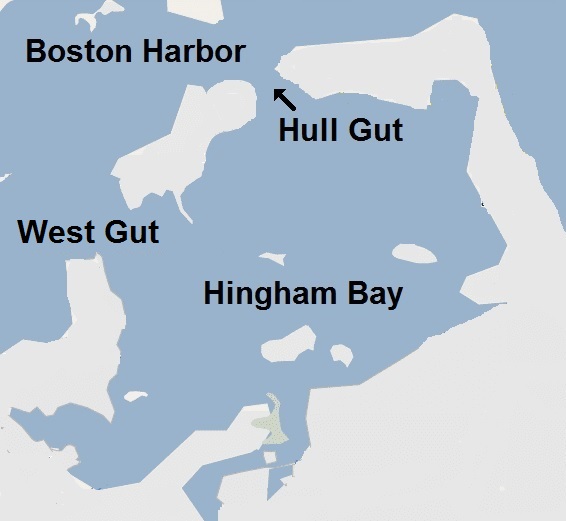
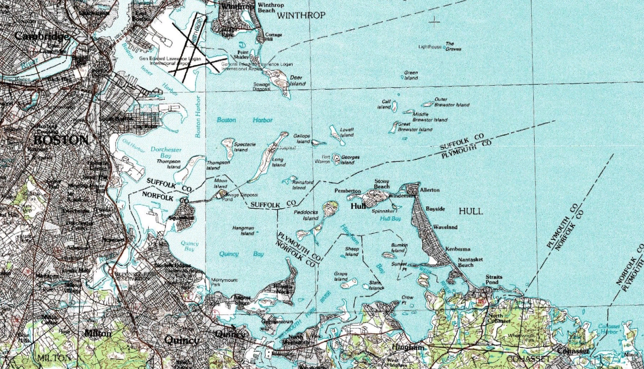
Hull Gut is a gut (a narrow, naturally dredged deep-water channel) about half a mile wide and thirty-five feet deep, in Boston Harbor running between Pemberton Point in Hull and the East Head of Peddocks Island. Along with its sister channel, West Gut, which runs between the West Head of Peddocks Island and Hough's Neck in Quincy, Hull Gut forms the southern entrance to the Inner Harbor connecting it to Hingham Bay. To the north the gut intersects with the deep-water shipping lane Nantasket Roads. Strong cross-currents and often heavy traffic make the gut a dangerous waterway. The channel is used by oil tankers and other freighters bound for industries around the Weymouth Fore River in Braintree, Weymouth, and Quincy and, historically, was used by the shipbuilding industry Shipbuilding is the construction of ships and other floating vessels. It normally takes place in a specialized facility known as a shipyard. Shipbuilders, also called shipwrights, follow a specializ ... [...More Info...] [...Related Items...] OR: [Wikipedia] [Google] [Baidu] |
Gut (coastal Geography)
A gut is a narrow coastal body of water, a channel or strait, usually one that is subject to strong tidal currents flowing back and forth. The term is also used in some places for a small creek. Coastal channels Many guts are straits but some are at a river mouths where tidal currents are strong. The comparatively large quantities of water that flow quite quickly through a gut can cause heavy erosion that results in a channel deeper than the rest of the surrounding seabed, and the currents may present a hazard to ships and boats at times. The term "gut" is primarily (though not exclusively) applied to channels of the coastal waters of the Atlantic coast of North America. A similar term of related but not identical meaning, " gat", is applied to some narrow waterways of the North Sea and Baltic Sea coasts of Europe. Some bodies of water named "Gut" are: *Digby Gut in Nova Scotia *Mira Gut, at the confluence of the Mira River with the Atlantic Ocean at the settlement of Mira Gut ... [...More Info...] [...Related Items...] OR: [Wikipedia] [Google] [Baidu] |
Peddocks Island
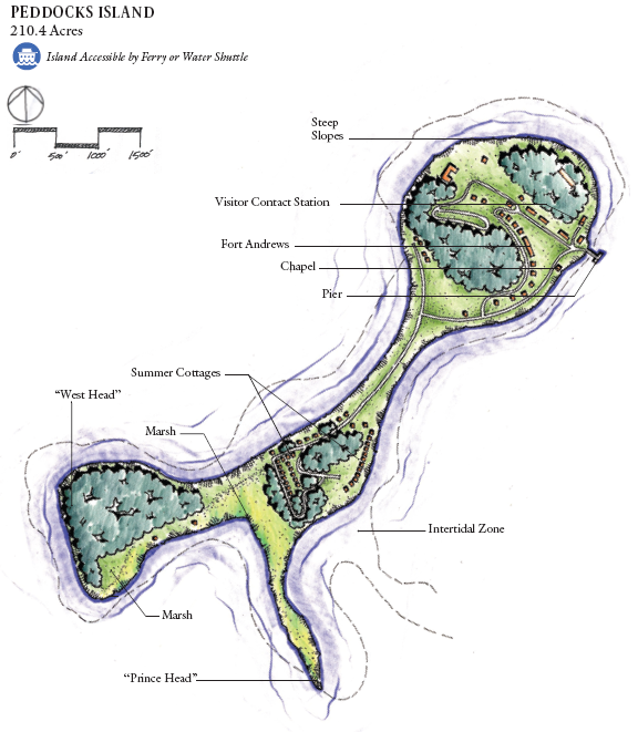
Peddocks Island is one of the largest islands in Boston Harbor. Since 1996 it has formed part of the Boston Harbor Islands National Recreation Area. Managed by the Department of Conservation and Recreation, the island is home to the now-defunct Fort Andrews, active in harbor defense from 1904 to the end of World War II, on its eastern end, and a group of privately owned cottages on its western end. Campsites are also on the eastern end. Ferry service between Peddocks Island and Georges Island (where Fort Warren stands) is provided on a seasonal basis. Topography Peddocks Island lies across Hull Gut from the Pemberton neighborhood of Hull to the north and across West Gut to Nut Island & Houghs Neck to the west. The island is located at 42° 17' 32.6" North latitude and 70° 56' 21.6" West longitude. The area of the island is , its total acreage at low tide is 288, and its highest elevation is 80 feet. Boasting the longest island shoreline in Boston Harbor, Peddocks Island com ... [...More Info...] [...Related Items...] OR: [Wikipedia] [Google] [Baidu] |
Boston Harbor
Boston Harbor is a natural harbor and estuary of Massachusetts Bay, and is located adjacent to the city of Boston, Massachusetts. It is home to the Port of Boston, a major shipping facility in the northeastern United States. History Since its discovery to Europeans by John Smith in 1614, Boston Harbor has been an important port in American history. Early on, it was recognized by Europeans as one of the finest natural harbors in the world due to its depth and natural defense from the Atlantic as a result of the many islands that dot the harbor. It was also favored due to its access to the Charles River, Neponset River and Mystic River which made travel from the harbor deeper into Massachusetts far easier. It was the site of the Boston Tea Party, as well as almost continuous building of wharves, piers, and new filled land into the harbor until the 19th century. By 1660, almost all imports came to the greater Boston area and the New England coast through the waters of Boston ... [...More Info...] [...Related Items...] OR: [Wikipedia] [Google] [Baidu] |
Pemberton Point
Pemberton Point (formerly known as Windmill Point) is a peninsula in Hull, Massachusetts. It is located at the tip of the Nantasket Peninsula, in Boston Harbor. History Historic manuscripts have called the location "Windmill Point" since the 1820s. The windmills for which the point were named were used by two brothers to pump seawater into vats to be used for harvesting salt. The salt would then be used to pack fish. On July 13, 1909, fourteen-year-old Rosie Pitenhof swam across the Hull Gut from Peddocks Island to Pemberton Point and back, believed to be the first to do so. Hull High School, the town's public high school, opened on the point in 1957. Wind turbines An Enertech 40 kW wind turbine was installed on Pemberton Point and started energy production in March 1985. The turbine was funded by the Massachusetts Department of Energy Resources, and was sited adjacent to the high school. It was damaged beyond repair by a storm in March 1997, and was removed after ... [...More Info...] [...Related Items...] OR: [Wikipedia] [Google] [Baidu] |
Hull, Massachusetts
Hull is a town in Plymouth County, Massachusetts, United States, located on a peninsula at the southern edge of Boston Harbor. Its population was 10,072 at the 2020 census. Hull is the smallest town by land area in Plymouth County and the fourth smallest in the state. However, its population density is nearly four times that of Massachusetts as a whole. Hull is home to the popular resort community of Nantasket Beach and has been the summer home to several luminaries throughout the years, including Calvin Coolidge and former Boston mayor John F. Fitzgerald (also known as "Honey Fitz"), the father of Rose Kennedy and father-in-law of Joseph Kennedy Sr. History The Massachuset tribe called the area ''Nantasket'', meaning "at the strait" or "low-tide place". It is a series of islands connected by sandbars forming Nantasket Peninsula, on which the Plymouth Colony established a trading post in 1621 for trade with the Wampanoags. The town was first settled in 1622 and officia ... [...More Info...] [...Related Items...] OR: [Wikipedia] [Google] [Baidu] |
Hough's Neck
Houghs Neck is a one-square-mile (2.6 km2) peninsula in Quincy, Massachusetts. It is surrounded by Quincy Bay, Hingham Bay and Rock Island Cove. It is lined by Perry Beach, which runs along Manet Avenue; Nut Island, which is just beyond Great Hill at the very end of the peninsula; and Edgewater Drive. Houghs Neck is commonly referred to by locals as "The Neck" or "God's Country," and its residents as "Neckahs" ("Neckers") or "Neck Birds". The Hough's Neck Pumping Station (or the "Pumpy" by the locals) is also part of the Boston Harbor Islands, along with Racoon Island, which can be walked to at low tide. Raccoon Island covers .3 sq. miles. In 1778, founding father John Adams left for a diplomatic mission to France from Houghs Neck instead of Boston, to evade capture by the British. History Houghs Neck is named for Atherton Hough, previously mayor of Boston, England, who was granted the land in 1636 as a farm and orchard. The neighborhood's elementary school is also named ... [...More Info...] [...Related Items...] OR: [Wikipedia] [Google] [Baidu] |
Quincy, Massachusetts
Quincy ( ) is a coastal U.S. city in Norfolk County, Massachusetts, United States. It is the largest city in the county and a part of Greater Boston, Metropolitan Boston as one of Boston's immediate southern suburbs. Its population in 2020 was 101,636, making it the seventh-largest city in the U.S. state, state. Known as the "City of Presidents", Quincy is the birthplace of two President of the United States, U.S. presidents—John Adams and his son John Quincy Adams—as well as John Hancock (a President of the Continental Congress and the first signer of the United States Declaration of Independence, Declaration of Independence) and the first and third Governor of Massachusetts. First settled in 1625, Quincy was briefly part of Dorchester, Boston, Dorchester before becoming the north precinct of Braintree, Massachusetts, Braintree in 1640. In 1792, Quincy was split off from Braintree; the new town was named after Colonel John Quincy, maternal grandfather of Abigail Adams and af ... [...More Info...] [...Related Items...] OR: [Wikipedia] [Google] [Baidu] |
Hingham Bay
Hingham Bay is the easternmost of the three small bays of outer Boston Harbor, part of Massachusetts Bay and forming the western shoreline of the town of Hull and the northern shoreline of Hingham in the United States state of Massachusetts. It lies east of Quincy Bay and is met at the southwest by the mouth of Weymouth Fore River, also forming part of the waterfront of Weymouth. The bay is home to several of the Boston Harbor Islands. Description The bay is roughly wide east to west and long south to north. It is nearly enclosed on all sides, surrounded by peninsulas, former islands joined to the mainland, and Peddocks Island. There are two passages to Nantasket Roads and the Atlantic Ocean, one a opening at Hull Gut between Peddocks Island and Windmill Point in the northwest and a passage at West Gut between the island and Hough's Neck at Nut Island, part of the city of Quincy. Along the western portion of Hingham Bay a wide, deep channel allows oceangoing ships access ... [...More Info...] [...Related Items...] OR: [Wikipedia] [Google] [Baidu] |
Weymouth Fore River
Weymouth Fore River is a small bay or estuary in eastern Massachusetts and is part of the Massachusetts Bay watershed. The headwater of Weymouth Fore River is formed by the confluence of the Monatiquot River and Smelt Brook in the Weymouth Landing area of Braintree. From Weymouth Landing, the tidal river marks the boundary between Braintree and Weymouth, flowing northeast for and then north for before widening considerably and turning west northwest for . At this point the river's western shore is now in Quincy at the south end of the former Fore River Shipyard. Here the river turns north northeast for as it passes through a heavily industrialized area around the former shipyard and is crossed by the Fore River Bridge, a lift bridge which carries Massachusetts Route 3A between Quincy and Weymouth. A quarter mile beyond the bridge Weymouth Fore River is joined by Town River at Germantown, gradually widening to nearly as it travels the final northeast before ending as it en ... [...More Info...] [...Related Items...] OR: [Wikipedia] [Google] [Baidu] |
Braintree, Massachusetts
Braintree (), officially the Town of Braintree, is a municipality in Norfolk County, Massachusetts, United States. Although officially known as a towBraintree is a city, with a mayor-council government, mayor-council form of government, and is considered a city under Massachusetts law. The population was 39,143 at the 2020 census. The city is part of the Greater Boston area with access to the MBTA Red Line, and is a member of the Metropolitan Area Planning Council's South Shore Coalition. The first mayor of Braintree was Joe Sullivan who served until January 2020. The current mayor of Braintree is Charles Kokoros. Braintree, Massachusetts, is named after Braintree, Essex, in England. The town was first chartered in 1640. Later, some sections of Braintree formed separate municipalities: Quincy (1792), Randolph (1793), and Holbrook (1872). History European settlers first arrived in 1625. Subsequent to their arrival, the town was colonized in 1635, and ultimately incorp ... [...More Info...] [...Related Items...] OR: [Wikipedia] [Google] [Baidu] |
Weymouth, Massachusetts
("To Work Is to Conquer") , image_map = Norfolk County Massachusetts incorporated and unincorporated areas Weymouth highlighted.svg , mapsize = 250px , map_caption = Location in Norfolk County in Massachusetts , pushpin_map = , pushpin_label_position = right , pushpin_label = , pushpin_map_caption = Location in Massachusetts , coordinates = , subdivision_type = List of sovereign states, Country , subdivision_name = , subdivision_type1 = U.S. state, State , subdivision_type2 = List of counties in Massachusetts, County , subdivision_name1 = , subdivision_name2 = Norfolk County, Massachusetts, Norfolk , established_title = Settled , established_date = 1622 , established_title2 = Incorporated , established_date2 = September 2, 1635 , government_type = Mayor–council government, Mayor-council , leader ... [...More Info...] [...Related Items...] OR: [Wikipedia] [Google] [Baidu] |
Fore River Shipyard
Fore River Shipyard was a shipyard owned by General Dynamics Corporation located on Weymouth Fore River in Braintree and Quincy, Massachusetts. It began operations in 1883 in Braintree, and moved to its final location on Quincy Point in 1901. In 1913, it was purchased by Bethlehem Steel, and later transferred to Bethlehem Shipbuilding Corporation. It was sold to General Dynamics in 1963, and closed in 1986. During its operation, yardworkers constructed hundreds of ships, for both military and civilian clients. Most of the ships at the yard were built for the United States Navy, with its first government contract for the destroyer . The yard also built early submarines for Electric Boat, including and . Fore River also constructed the battleship , and the cruisers and as well as the Navy's first carrier and its successor . Fore River produced multiple foreign ships for various navies around the world including five Type 1 submarines for the Imperial Japanese Navy, ten su ... [...More Info...] [...Related Items...] OR: [Wikipedia] [Google] [Baidu] |


