|
Horsethief Canyon (Alberta)
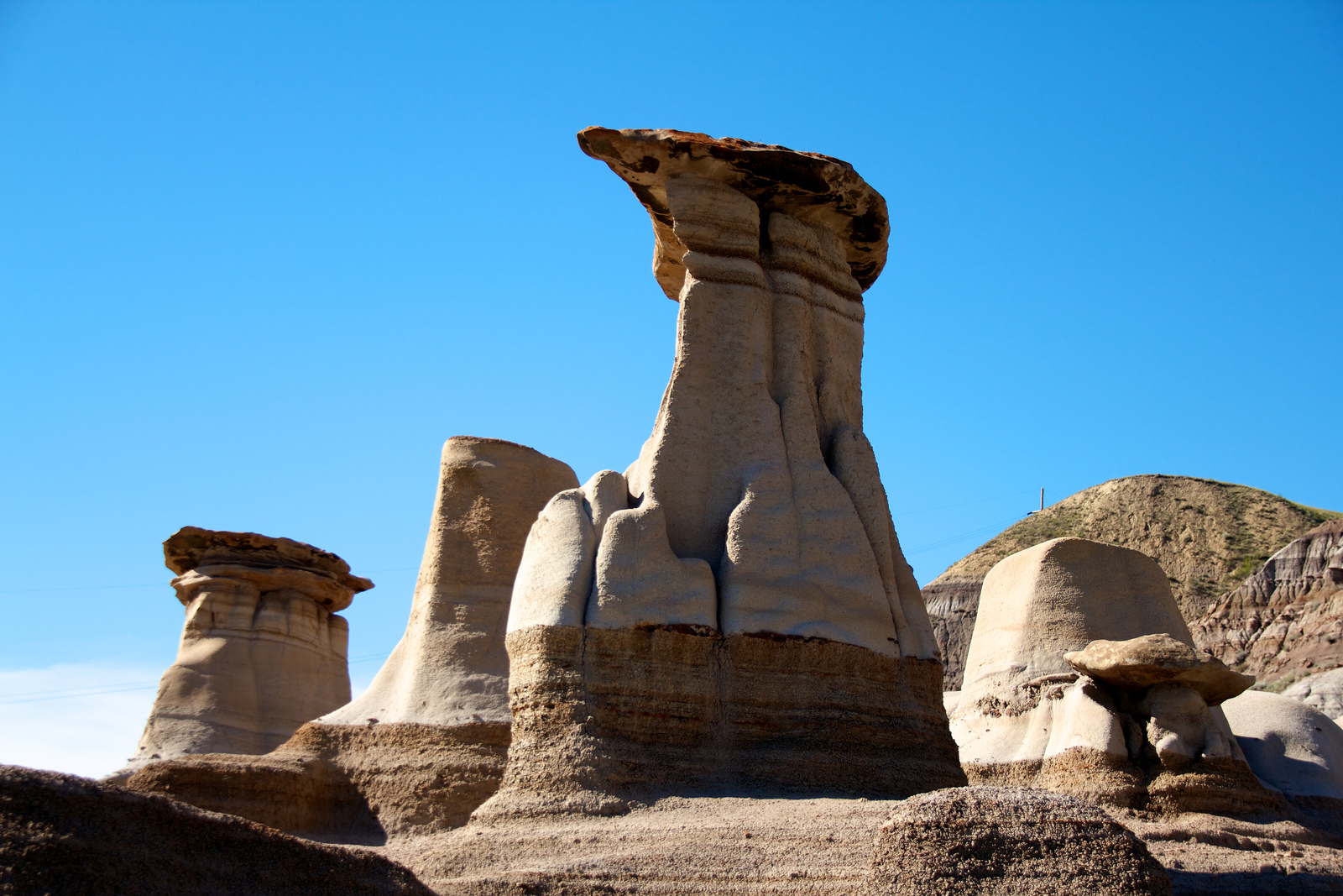
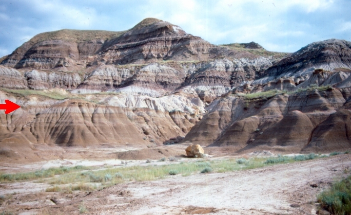
Horsethief Canyon is found northwest of the town of Drumheller, in Starland County in the province of Alberta, Canada. It is on the east bank of the Red Deer River, along Highway 838 (known locally as North Dinosaur Trail). Both Horsethief Canyon and Horseshoe Canyon are distinctive features of the surrounding badlands of central Alberta. Although the two canyons look similar, they are separated by several kilometres and were created by different tributaries of the Red Deer River. The name "Horsethief" was given to this area because of an illegal horse trade network used in the last century. Horses being smuggled illegally between the United States and Alberta were supposedly hidden in this canyon, but the true origin of the name is not clear. See also * Geography of Alberta Alberta is one of the thirteen provinces and territories of Canada. Located in Western Canada, the province has an area of and is bounded to the south by the United States state of Montana along 4 ... [...More Info...] [...Related Items...] OR: [Wikipedia] [Google] [Baidu] |
Horsethief Canyon
Horsethief Canyon, is a canyon comprising the upper part of the Summit Valley in San Bernardino County, California. Its head lies at at an elevation of 3,800 feet just east of the summit of Cajon Pass, and its mouth at an elevation of . California State Routes 138 and 173 pass through it. There is also a separate Horsethief Canyon in San Diego County, California, near Pine Valley, California and the Mexico–United States border. It is located in the Cleveland National Forest, in the Pine Creek Wilderness Pine Creek Wilderness is a wilderness area designated by Congress in 1984. It is located entirely in California, and managed by United States Forest Service as part of the Cleveland National Forest. The wilderness is a sloping area of , ranging f .... References {{Authority control Valleys of San Bernardino County, California ... [...More Info...] [...Related Items...] OR: [Wikipedia] [Google] [Baidu] |
Drumheller
Drumheller is a town on the Red Deer River in the badlands of Central Alberta, east-central Alberta, Canada. It is northeast of Calgary and south of Stettler, Alberta, Stettler. The Drumheller portion of the Red Deer River valley, often referred to as Dinosaur Valley, has an approximate width of and an approximate length of . Drumheller was named after Samuel Drumheller, who, after purchasing the homestead of Thomas Patrick Greentree, had it surveyed into the original Drumheller townsite and put lots on the market in 1911. Also in 1911, Samuel Drumheller started coal mining operations near the townsite. Drumheller got a railway station in 1912. It was then incorporated as a village on May 15, 1913, a town on March 2, 1916 and a city on April 3, 1930. Over a 15-year period, Drumheller's population increased from 312 in 1916 to 2,987 in 1931 shortly after becoming a city. Drumheller boomed until the end of the Second World War when coal lost most of its value. The City of ... [...More Info...] [...Related Items...] OR: [Wikipedia] [Google] [Baidu] |
Starland County
Starland County is a municipal district located in southern Alberta, Canada. History The municipality was incorporated in 1912, and established in the current boundaries in 1943, under the name ''Municipal District of Morrin No. 277''. The name was changed the same year to ''Municipal District of Starland No. 277''. Its name was changed again to Starland County in 1998. Geography Communities and localities The following urban municipalities are surrounded by Starland County. ;Cities *none ;Towns *none ;Villages * Delia * Morrin (location of municipal office) * Munson ; Summer villages *none The following hamlets are located within Starland County. ;Hamlets * Craigmyle *Michichi * Rowley * Rumsey (dissolved from village status in 1995) The following localities are located within Starland County. ;Localities *Dinosaur *Dowling Lake *Gartly *Rainbow *Stonelaw *Verdant Valley *Victor Demographics In the 2021 Census of Population conducted by Statistics Canada, ... [...More Info...] [...Related Items...] OR: [Wikipedia] [Google] [Baidu] |
Alberta
Alberta ( ) is one of the thirteen provinces and territories of Canada. It is part of Western Canada and is one of the three prairie provinces. Alberta is bordered by British Columbia to the west, Saskatchewan to the east, the Northwest Territories (NWT) to the north, and the U.S. state of Montana to the south. It is one of the only two landlocked provinces in Canada (Saskatchewan being the other). The eastern part of the province is occupied by the Great Plains, while the western part borders the Rocky Mountains. The province has a predominantly continental climate but experiences quick temperature changes due to air aridity. Seasonal temperature swings are less pronounced in western Alberta due to occasional Chinook winds. Alberta is the fourth largest province by area at , and the fourth most populous, being home to 4,262,635 people. Alberta's capital is Edmonton, while Calgary is its largest city. The two are Alberta's largest census metropolitan areas. More tha ... [...More Info...] [...Related Items...] OR: [Wikipedia] [Google] [Baidu] |
Red Deer River
The Red Deer River is a river in Alberta and a small portion of Saskatchewan, Canada. It is a major tributary of the South Saskatchewan River and is part of the larger Saskatchewan-Nelson system that empties into Hudson Bay. Red Deer River has a total length of and a drainage area of . Its mean discharge is . The river got its name from the translation of ''Was-ka-soo seepee'' which means "elk river" in the Cree language. "Red deer" was an alternative name for elk, referring to a closely related Eurasian species. Communities located along the Red Deer River include Sundre, Red Deer, Drumheller, and Empress, The city of Brooks, as well as Dinosaur Provincial Park, are also located in the Red Deer River Basin. A glacial flood about 18,000 years ago eroded out a portion of this basin and apparently all or most of the scenic badlands bearing the dinosaur and other Cretaceous fossils. History Joseph Tyrrell discovered a huge coal seam here in 1883, besides large dinosa ... [...More Info...] [...Related Items...] OR: [Wikipedia] [Google] [Baidu] |
Dinosaur Trail
The Dinosaur Trail is a circular tourist route in the province of Alberta, Canada, located in the Canadian badlands paralleling the Red Deer River on both sides, from Drumheller to the Bleriot Ferry. It is divided in two segments, with the South Dinosaur Trail following the south side of the river and uses portions of Highway 575 and Highway 837, while North Dinosaur Trail follows the north side of the river and is the entirety of Highway 838. The north and south segments of Dinosaur Trail are connected by the Highway 9 / Highway 56 concurrency within Drumheller. Route description The Dinosaur Trail begins at the 2 Street SW / South Railway Avenue intersection (Highway 9 / 56) in Drumheller and travels west along South Railway Avenue (Highway 575). On the western outskirts of the Drumheller townsite, it passes the amphitheatre which houses the Canadian Badlands Passion Play, and continues past the former hamlet of Nacmine, wh ... [...More Info...] [...Related Items...] OR: [Wikipedia] [Google] [Baidu] |
Horseshoe Canyon Formation
The Horseshoe Canyon Formation is a stratigraphic unit of the Western Canada Sedimentary Basin in southwestern Alberta. It takes its name from Horseshoe Canyon, an area of badlands near Drumheller. The Horseshoe Canyon Formation is part of the Edmonton Group and is up to thick. It is of Late Cretaceous age, Campanian to early Maastrichtian stage (Edmontonian Land-Mammal Age), and is composed of mudstone, sandstone, carbonaceous shales, and coal seams. A variety of depositional environments are represented in the succession, including floodplains, estuarine channels, and coal swamps, which have yielded a diversity of fossil material. Tidally-influenced estuarine point bar deposits are easily recognizable as Inclined Heterolithic Stratification (IHS). Brackish-water trace fossil assemblages occur within these bar deposits and demonstrate periodic incursion of marine waters into the estuaries. The Horseshoe Canyon Formation crops out extensively in the area around Drumheller, a ... [...More Info...] [...Related Items...] OR: [Wikipedia] [Google] [Baidu] |
Badlands
Badlands are a type of dry terrain where softer sedimentary rocks and clay-rich soils have been extensively eroded."Badlands" in ''Chambers's Encyclopædia''. London: George Newnes, 1961, Vol. 2, p. 47. They are characterized by steep slopes, minimal vegetation, lack of a substantial regolith, and high drainage density.A.J. Parsons and A.D. Abrahams, Editors (2009) ''Geomorphology of Desert Environments'' (2nd ed.) Springer Science & Business Media Ravines, gullies, buttes, hoodoos and other such geologic forms are common in badlands. Badlands are found on every continent except Antarctica, being most common where there are unconsolidated sediments. They are often difficult to navigate by foot, and are unsuitable for agriculture. Most are a result of natural processes, but destruction of vegetation by overgrazing or pollution can produce anthropogenic badlands. Badlands topography Badlands are characterized by a distinctive badlands topography. This is terrain in which w ... [...More Info...] [...Related Items...] OR: [Wikipedia] [Google] [Baidu] |
The Globe And Mail
''The Globe and Mail'' is a Canadian newspaper printed in five cities in western and central Canada. With a weekly readership of approximately 2 million in 2015, it is Canada's most widely read newspaper on weekdays and Saturdays, although it falls slightly behind the ''Toronto Star'' in overall weekly circulation because the ''Star'' publishes a Sunday edition, whereas the ''Globe'' does not. ''The Globe and Mail'' is regarded by some as Canada's " newspaper of record". ''The Globe and Mail''s predecessors, '' The Globe'' and ''The Mail and Empire'' were both established in the 19th century. The former was established in 1844, while the latter was established in 1895 through a merger of ''The Toronto Mail'' and the ''Toronto Empire''. In 1936, ''The Globe'' and ''The Mail and Empire'' merged to form ''The Globe and Mail''. The newspaper was acquired by FP Publications in 1965, who later sold the paper to the Thomson Corporation in 1980. In 2001, the paper merged with broadcast ... [...More Info...] [...Related Items...] OR: [Wikipedia] [Google] [Baidu] |
Geography Of Alberta
Alberta is one of the thirteen provinces and territories of Canada. Located in Western Canada, the province has an area of and is bounded to the south by the United States state of Montana along 49° north for ; to the east at 110° west by the province of Saskatchewan for ; and at 60° north the Northwest Territories for . The southern half of the province borders British Columbia along the Continental Divide of the Americas on the peaks of the Rocky Mountains, while the northern half borders British Columbia along the 120th meridian west. Along with Saskatchewan it is one of only two landlocked provinces or territories. Terrain Alberta's landscape is marked by the impact of the Wisconsin Glaciation, about 75,000 to 11,000 years ago, when the entire future province was covered in ice. As the ice sheet receded, the landscape was changed, and large amounts of glacial till were left behind. The southern portion consists chiefly of plains that are almost entirely treeless. As ... [...More Info...] [...Related Items...] OR: [Wikipedia] [Google] [Baidu] |


