|
Historic Trails And Roads In The United States
There are many historic trails and roads in the United States which were important to the settlement and development of the United States including those used by American Indians. The lists below include only those routes in use prior to the creation of the ''American Highway System'' in 1926. Many more local routes are discussed at entries for the relevant town. Settlement routes * Albany Post Road, in use by 1642, from Bowling Green (New York City) to Albany, called "Broadway" for long stretches * Bozeman Trail from Virginia City, Montana, to central Wyoming * California Road established 1849, from Fort Smith, Arkansas, to California * California Trail from Missouri to California. * Carolina Road from Roanoke, Virginia, on the Great Wagon Road through the Piedmont to Augusta, Georgia. * Cherokee Trail along the Arkansas River from Indian Territory to Wyoming. * Coushatta-Nacogdoches Trace (or Natchitoches) * El Camino Real (California) * El Camino Real de Tierra Adentro * ... [...More Info...] [...Related Items...] OR: [Wikipedia] [Google] [Baidu] |
Native Americans In The United States
Native Americans, also known as American Indians, First Americans, Indigenous Americans, and other terms, are the Indigenous peoples of the mainland United States ( Indigenous peoples of Hawaii, Alaska and territories of the United States are generally known by other terms). There are 574 federally recognized tribes living within the US, about half of which are associated with Indian reservations. As defined by the United States Census, "Native Americans" are Indigenous tribes that are originally from the contiguous United States, along with Alaska Natives. Indigenous peoples of the United States who are not listed as American Indian or Alaska Native include Native Hawaiians, Samoan Americans, and the Chamorro people. The US Census groups these peoples as " Native Hawaiian and other Pacific Islanders". European colonization of the Americas, which began in 1492, resulted in a precipitous decline in Native American population because of new diseases, wars, ethni ... [...More Info...] [...Related Items...] OR: [Wikipedia] [Google] [Baidu] |
Fort Wilkinson .
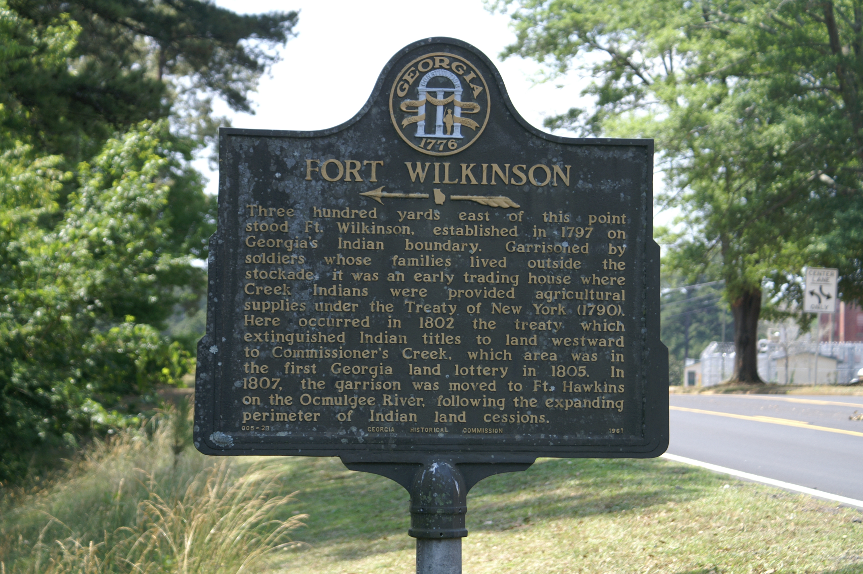
Fort Wilkinson was a U.S. fort near Milledgeville, Georgia established in 1797 near the Oconee River. It supplanted Fort Fidius. A historical marker commemorates the site. The fort carried out trading relations with Creek peoples through the United States factory. The marker is located on Fort Wilkinson Road. The 1802 Treaty of Fort Wilkinson deals with relations with the Creek. In 1807, the garrison was moved to Ft. Hawkins on the Ocmulgee River The Ocmulgee River () is a western tributary of the Altamaha River, approximately 255 mi (410 km) long, in the U.S. state of Georgia. It is the westernmost major tributary of the Altamaha. References Populated places in Georgia (U.S. state) {{BaldwinCountyGA-geo-stub ...[...More Info...] [...Related Items...] OR: [Wikipedia] [Google] [Baidu] |
Federal Road (Creek Lands)
The Federal Road through the territory of the Creek people was a project that started in 1805 when the Creek gave permission for the development of a "horse path" through their nation for more efficient mail delivery between Washington City (modern-day Washington, D.C.) and New Orleans, Louisiana. This section started at Fort Wilkinson near Milledgeville, Georgia, and ended at Fort Stoddert near Mobile, Alabama. By the time of the War of 1812, the Federal Road began in Augusta, Georgia, ran through Fort Hawkins (in Macon, Georgia), on to Fort Mitchell, Alabama (near modern Phenix City, Alabama), and was connected via the Three Notch Road to Pensacola in Spanish West Florida. The Federal Road was at first for mail delivery. It was widened into a war road during 1811, and used during the Creek War (1813–14). The result was removal of most of the Creek people to the West. Another Federal Road (Cherokee lands) went from Savannah, Georgia through northern Georgia to Knoxville, ... [...More Info...] [...Related Items...] OR: [Wikipedia] [Google] [Baidu] |
Knoxville, Tennessee
Knoxville is a city in and the county seat of Knox County, Tennessee, Knox County in the U.S. state of Tennessee. As of the 2020 United States census, Knoxville's population was 190,740, making it the largest city in the East Tennessee Grand Divisions of Tennessee, Grand Division and the state's third largest city after Nashville, Tennessee, Nashville and Memphis, Tennessee, Memphis.U.S. Census Bureau2010 Census Interactive Population Search. Retrieved: December 20, 2011. Knoxville is the principal city of the Knoxville Metropolitan Area, Knoxville Metropolitan Statistical Area, which had an estimated population of 869,046 in 2019. First settled in 1786, Knoxville was the first capital of Tennessee. The city struggled with geographic isolation throughout the early 19th century. The History of rail transportation in the United States#Early period (1826–1860), arrival of the railroad in 1855 led to an economic boom. The city was bitterly Tennessee in the American Civil War#Tenne ... [...More Info...] [...Related Items...] OR: [Wikipedia] [Google] [Baidu] |
Chattanooga, Tennessee
Chattanooga ( ) is a city in and the county seat of Hamilton County, Tennessee, United States. Located along the Tennessee River bordering Georgia, it also extends into Marion County on its western end. With a population of 181,099 in 2020, it is Tennessee's fourth-largest city and one of the two principal cities of East Tennessee, along with Knoxville. It anchors the Chattanooga metropolitan area, Tennessee's fourth-largest metropolitan statistical area, as well as a larger three-state area that includes Southeast Tennessee, Northwest Georgia, and Northeast Alabama. Chattanooga was a crucial city during the American Civil War, due to the multiple railroads that converge there. After the war, the railroads allowed for the city to grow into one of the Southeastern United States' largest heavy industrial hubs. Today, major industry that drives the economy includes automotive, advanced manufacturing, food and beverage production, healthcare, insurance, tourism, and back office ... [...More Info...] [...Related Items...] OR: [Wikipedia] [Google] [Baidu] |
Athens, Georgia
Athens, officially Athens–Clarke County, is a consolidated city-county and college town in the U.S. state of Georgia. Athens lies about northeast of downtown Atlanta, and is a satellite city of the capital. The University of Georgia, the state's flagship public university and an R1 research institution, is in Athens and contributed to its initial growth. In 1991, after a vote the preceding year, the original City of Athens abandoned its charter to form a unified government with Clarke County, referred to jointly as Athens–Clarke County. As of 2020, the U.S. Census Bureau's population of the consolidated city-county (all of Clarke County except Winterville and a portion of Bogart) was 127,315. Athens is the sixth-largest city in Georgia, and the principal city of the Athens metropolitan area, which had a 2020 population of 215,415, according to the U.S. Census Bureau. Metropolitan Athens is a component of the larger Atlanta–Athens–Clarke County–Sandy Springs Combin ... [...More Info...] [...Related Items...] OR: [Wikipedia] [Google] [Baidu] |
Federal Road (Cherokee Lands)
The Federal Road through Cherokee lands, originally called the Georgia Road, was a federal toll highway passing through the Cherokee Nation in the northern part of the U.S. state of Georgia. From 1805 to the 1840s, the road linked Savannah, Georgia with Knoxville, Tennessee. The road also opened Cherokee lands to settlement. Another Federal Road (Creek lands) passed through southern Alabama. Geography The Federal Road ran from the location of modern-day Ringgold to Athens, Georgia, passing southeast through the Cherokee Nation and the modern day Georgia counties of Walker, Catoosa, Whitfield, Murray, Gilmer, Pickens, Dawson, Forsyth, Hall, Jackson, and Clarke counties. History The Georgia Road was built from 1803 to 1805 through the newly formed Cherokee Nation on a land concession secured with the 1805 Treaty of Tellico. The Georgia Road opened in 1805. In 1819 the road was improved and called 'the Federal Road' but no federal funds were used in its creation. As whi ... [...More Info...] [...Related Items...] OR: [Wikipedia] [Google] [Baidu] |
Nichols, Connecticut
Nichols, a historic village in southeastern Trumbull in Fairfield County, Connecticut, is named after the family who maintained a large farm in its center for almost 300 years. The Nichols Farms Historic District, which encompasses part of the village, is listed on the National Register of Historic Places. Originally home to the Golden Hill Paugussett Indian Nation, the area was colonized by the English during the Great Migration of the 1630s as a part of the coastal settlement of Stratford. The construction of the Merritt Parkway through the village, and the subsequent closing of stores and factories, turned the village into a bedroom community in 1939. Aviation pioneer Igor Sikorsky lived in three separate homes in Nichols during his active years between 1928 and 1951, when he designed, built and flew fixed-wing aircraft and put the helicopter into mass production for the first time. Golden Hill Paugussett Indian Nation The Golden Hill Paugussett Indian Nation is a Conne ... [...More Info...] [...Related Items...] OR: [Wikipedia] [Google] [Baidu] |
Stratford, Connecticut
Stratford is a town in Fairfield County, Connecticut, United States. It is situated on Long Island Sound at the mouth of the Housatonic River. Stratford is in the Bridgeport–Stamford–Norwalk Metropolitan Statistical Area. It was settled by Puritans in 1639. The population was 52,355 as of the 2020 census. It is bordered on the west by Bridgeport, to the north by Trumbull and Shelton, and on the east by Milford (across the Housatonic River). Stratford has a historical legacy in aviation, the military, and theater. History Founding and Puritan era Stratford was founded in 1639 by Puritan leader Reverend Adam Blakeman, William Beardsley, and either 16 families (according to legend) or approximately 35 families (suggested by later research) who had recently arrived in Connecticut from England seeking religious freedom. In 1639 the General Court in Hartford made reference to the town as the "new plantation at Pequannock". In 1640 the community was known as Cupheag, a ... [...More Info...] [...Related Items...] OR: [Wikipedia] [Google] [Baidu] |
Boston Post Road
The Boston Post Road was a system of mail-delivery routes between New York City and Boston, Massachusetts that evolved into one of the first major highways in the United States. The three major alignments were the Lower Post Road (now U.S. Route 1 (US 1) along the shore via Providence, Rhode Island), the Upper Post Road (now US 5 and US 20 from New Haven, Connecticut by way of Springfield, Massachusetts), and the Middle Post Road (which diverged from the Upper Road in Hartford, Connecticut and ran northeastward to Boston via Pomfret, Connecticut). In some towns, the area near the Boston Post Road has been placed on the National Register of Historic Places, since it was often the first road in the area, and some buildings of historical significance were built along it. The Boston Post Road Historic District, including part of the road in Rye, New York, has been designated a National Historic Landmark. The Post Road is also famous for milestones that da ... [...More Info...] [...Related Items...] OR: [Wikipedia] [Google] [Baidu] |
Connecticut Route 108
Route 108 in the U.S. state of Connecticut, locally called Nichols Avenue and Huntington Turnpike, is a two-lane state highway that runs northerly from U.S. Route 1 in Connecticut, US 1, Boston Post Road in Stratford, Connecticut, Stratford, through Trumbull, Connecticut, Trumbull, to Route 110 (Connecticut), Route 110 in downtown Shelton, Connecticut, Shelton. Originally called the Farm Highway, it was laid out to the south side of Mischa Hill in Trumbull on December 7, 1696 and is considered to be the third oldest documented highway in Connecticut after the Mohegan Road (Route 32 (Connecticut), Route 32) in Norwich, Connecticut, Norwich (1670) and the Boston Post Road or US 1 (1673). The section of Nichols Avenue from the Stratford-Trumbull town line to Huntington Turnpike in Trumbull is known as the Trooper Ernest Morse Memorial Highway, named in honor of a Connecticut State Police, state trooper who was killed by gunfire on February 13, 1953, while trying to apprehend a suspect ... [...More Info...] [...Related Items...] OR: [Wikipedia] [Google] [Baidu] |


