|
Highland, Maryland
Highland is an unincorporated community and census-designated place in Howard County, Maryland, United States. As of the 2020 census it had a population of 1,133. It uses the 20777 zip code. Geography The community is located in southern Howard County at the junction of Highland Road, Maryland Route 216 and Maryland Route 108, and is still heavily influenced by its agrarian history; farms and horse fields are common in the area. The crossroads itself has a small-town feel, with a few shops that share in the rich history. Clarksville is to the north on MD 108, Laurel is to the southeast on MD 216, and Olney is to the west on MD 108. The center of Columbia is to the northeast. Demographics The crossroads As a rural crossroads, many of its community members took it upon themselves to maintain the historical sites and feel of the hamlet by founding the Greater Highland Crossroads Association (GHCA) in 2002. In 2014, the Crossroads were placed on the Preserve Howard top ten ... [...More Info...] [...Related Items...] OR: [Wikipedia] [Google] [Baidu] |
Census-designated Place
A census-designated place (CDP) is a concentration of population defined by the United States Census Bureau for statistical purposes only. CDPs have been used in each decennial census since 1980 as the counterparts of incorporated places, such as self-governing cities, towns, and villages, for the purposes of gathering and correlating statistical data. CDPs are populated areas that generally include one officially designated but currently unincorporated community, for which the CDP is named, plus surrounding inhabited countryside of varying dimensions and, occasionally, other, smaller unincorporated communities as well. CDPs include small rural communities, edge cities, colonias located along the Mexico–United States border, and unincorporated resort and retirement communities and their environs. The boundaries of any CDP may change from decade to decade, and the Census Bureau may de-establish a CDP after a period of study, then re-establish it some decades later. Most unin ... [...More Info...] [...Related Items...] OR: [Wikipedia] [Google] [Baidu] |
Laurel, Maryland
Laurel is a city in Maryland, United States, located midway between Washington and Baltimore on the banks of the Patuxent River. While the city limits are entirely in northern Prince George's County, outlying developments extend into Anne Arundel, Montgomery and Howard counties. Founded as a mill town in the early 19th century, Laurel expanded local industry and was later able to become an early commuter town for Washington and Baltimore workers following the arrival of the Baltimore and Ohio Railroad in 1835. Largely residential today, the city maintains a historic district centered on its Main Street, highlighting its industrial past. The Department of Defense is a prominent presence in the Laurel area today, with the Fort Meade Army base, the NSA and Johns Hopkins' Applied Physics Laboratory all located nearby. Laurel Park, a thoroughbred horse racetrack, is located just outside the city limits. History Natural history Many dinosaur fossils from the Cretaceous Era ar ... [...More Info...] [...Related Items...] OR: [Wikipedia] [Google] [Baidu] |
Highland, Maryland
Highland is an unincorporated community and census-designated place in Howard County, Maryland, United States. As of the 2020 census it had a population of 1,133. It uses the 20777 zip code. Geography The community is located in southern Howard County at the junction of Highland Road, Maryland Route 216 and Maryland Route 108, and is still heavily influenced by its agrarian history; farms and horse fields are common in the area. The crossroads itself has a small-town feel, with a few shops that share in the rich history. Clarksville is to the north on MD 108, Laurel is to the southeast on MD 216, and Olney is to the west on MD 108. The center of Columbia is to the northeast. Demographics The crossroads As a rural crossroads, many of its community members took it upon themselves to maintain the historical sites and feel of the hamlet by founding the Greater Highland Crossroads Association (GHCA) in 2002. In 2014, the Crossroads were placed on the Preserve Howard top ten ... [...More Info...] [...Related Items...] OR: [Wikipedia] [Google] [Baidu] |
American Civil War
The American Civil War (April 12, 1861 – May 26, 1865; also known by other names) was a civil war in the United States. It was fought between the Union ("the North") and the Confederacy ("the South"), the latter formed by states that had seceded. The central cause of the war was the dispute over whether slavery would be permitted to expand into the western territories, leading to more slave states, or be prevented from doing so, which was widely believed would place slavery on a course of ultimate extinction. Decades of political controversy over slavery were brought to a head by the victory in the 1860 U.S. presidential election of Abraham Lincoln, who opposed slavery's expansion into the west. An initial seven southern slave states responded to Lincoln's victory by seceding from the United States and, in 1861, forming the Confederacy. The Confederacy seized U.S. forts and other federal assets within their borders. Led by Confederate President Jefferson Davis, ... [...More Info...] [...Related Items...] OR: [Wikipedia] [Google] [Baidu] |
Boston Tea Party
The Boston Tea Party was an American political and mercantile protest by the Sons of Liberty in Boston, Massachusetts, on December 16, 1773. The target was the Tea Act of May 10, 1773, which allowed the British East India Company to sell tea from China in American colonies without paying taxes apart from those imposed by the Townshend Acts. The Sons of Liberty strongly opposed the taxes in the Townshend Act as a violation of their rights. Protesters, some disguised as Indigenous Americans, destroyed an entire shipment of tea sent by the East India Company. The demonstrators boarded the ships and threw the chests of tea into the Boston Harbor. The British government considered the protest an act of treason and responded harshly. The episode escalated into the American Revolution, becoming an iconic event of American history. Since then other political protests such as the Tea Party movement have referred to themselves as historical successors to the Boston protest of 1773. T ... [...More Info...] [...Related Items...] OR: [Wikipedia] [Google] [Baidu] |
Hickory Ridge (Highland, Maryland)
Hickory Ridge or White Hall is an historic property located in Highland in Howard County, Maryland, United States. It is registered in the Maryland Inventory of Historic Properties. The 500-acre property known as Hickory Ridge was surveyed by Henry Ridgely III (1690–1749) ("Col. Henry Ridgely"), a grandson of pioneering surveyor Henry Ridgely (1640–1710) who had been granted land by George II of Great Britain. On Henry Ridgely III's death in 1749, the tract was deeded to his son Greenberry Ridgely (1726–1783), who built a stone cottage the same year, which still stands. In 1760 or 1789, Ridgely began building the Georgian architecture primary residence. The building is a two-and-a-half-story structure made of Flemish brick bond. The farm had enslaved labor who worked in fields of tobacco and wheat, and were housed in stone "Quarters". Greenberry Ridgely's son Nicholas Greenberry Ridgely (1764–1829), a rich wine merchant in Baltimore, inherited the property in 1800 a ... [...More Info...] [...Related Items...] OR: [Wikipedia] [Google] [Baidu] |
Hickory Ridge, Columbia, Maryland
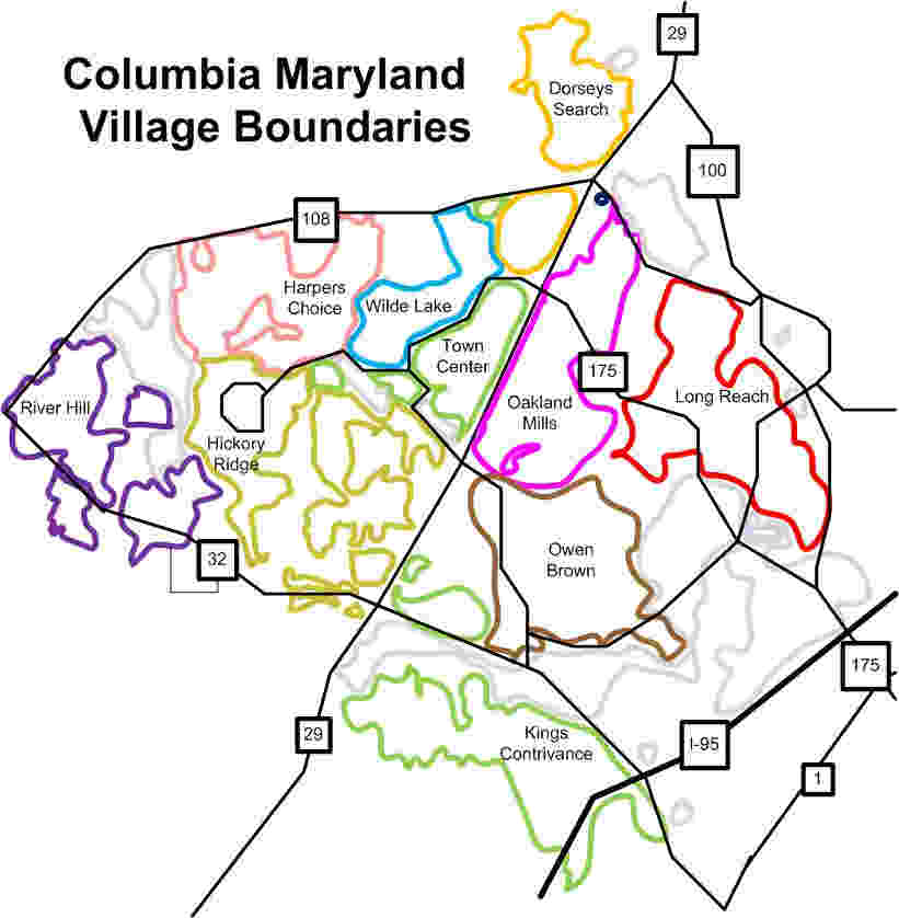
Hickory Ridge is one of the 10 villages in Columbia, Maryland, United States, located to the west of the Town Center with a 2014 population of 13,000 in 4,659 housing units. The village overlays the former postal community of Elioak. It was first occupied in 1974."History" hickoryridgecommunityassociation.org, accessed May 29, 2009 Neighborhoods in the village are Hawthorn, Clary's Forest, and Clemens Crossing. The name Hickory Ridge is derived from the 1749 estate " Hickory Ridge" in nearby , which later became the family home of ... [...More Info...] [...Related Items...] OR: [Wikipedia] [Google] [Baidu] |
The Rouse Company
The Rouse Company, founded by Hunter Moss and James W. Rouse in 1939, was a publicly held shopping mall and community developer from 1956 until 2004, when General Growth Properties (GGP) purchased the company. Beginnings - Moss-Rouse Company The Moss-Rouse Company was founded as a FHA mortgage company with a loan from Hunter Moss's sister. Rouse leveraged his knowledge as loan guarantee specialist at the Federal Housing Administration to establish a Baltimore-based mortgage company specializing in FHA backed loans. Moss-Rouse hired a World War Two Navy friend, Churchill G. Carey from Connecticut General, who in turn provided capital for future projects. Carey would hold positions ranging from president to CEO of the mortgage company subsidiary. In 1952-1953 the company built one of the first modern architecture office buildings on Saratoga Street in Baltimore, while also dropping its commercial lending business line. Jim Rouse hired his brother, Willard Rouse II, in 1952, and pa ... [...More Info...] [...Related Items...] OR: [Wikipedia] [Google] [Baidu] |
Howard County Department Of Planning And Zoning
The Howard County Department of Planning and Zoning (DPZ) manages planning and development in Howard County, Maryland, a Central Maryland jurisdiction equidistant between Baltimore, Maryland and Washington, D.C. Land use in Howard County has evolved over time. Roughly 60 percent of land in Howard County is dedicated, protected for rural uses, with the remaining 40 percent shifting over time from suburban to focused, mixed use nodes. Affluent Howard County offsets higher infrastructure costs of low-density development with high-valued homes that generate greater property and transfer taxes. The Department of Planning and Zoning provides staff and guidance to several citizen volunteer boards, including the Planning Board, the Agricultural Land Preservation Board the Historic District Commission, the Design Advisory Panel, and the Cemetery Preservation Advisory Board. The Director of the Department operates as executive secretary of the planning board with five members with five-year ... [...More Info...] [...Related Items...] OR: [Wikipedia] [Google] [Baidu] |
Columbia, Maryland
Columbia is a census-designated place in Howard County, Maryland. It is one of the principal communities of the Baltimore–Washington metropolitan area. It is a planned community consisting of 10 self-contained villages. Columbia began with the idea that a city could enhance its residents' quality of life. Creator and developer James W. Rouse saw the new community in terms of human values, rather than merely economics and engineering. Opened in 1967, Columbia was intended to not only eliminate the inconveniences of then-current subdivision design, but also eliminate racial, religious and class segregation. Columbia proper consists only of that territory governed by the Columbia Association, but larger areas are included under its name by the U.S. Postal Service and the Census Bureau. These include several other communities which predate Columbia, including Simpsonville, Atholton, and in the case of the census, part of Clarksville. The census-designated place had a popula ... [...More Info...] [...Related Items...] OR: [Wikipedia] [Google] [Baidu] |


