|
Hercules Dome
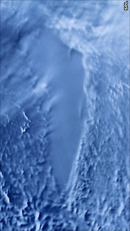
Hercules Dome () is a large ice dome between the Thiel Mountains and the Horlick Mountains in Antarctica. The feature was first mapped by the United States Geological Survey from U.S. Navy aerial photographs taken 1959–60. It was further delineated by the Scott Polar Research Institute – National Science Foundation – Technical University of Denmark airborne aerial radio echo sounding program, 1967–79, and named after the Lockheed LC-130 Hercules aircraft which was used on all echo sounding flights from 1969. The dome is notable for its unusually high number of subglacial lake A subglacial lake is a lake that is found under a glacier, typically beneath an ice cap or ice sheet. Subglacial lakes form at the boundary between ice and the underlying bedrock, where gravitational pressure decreases the pressure melting point ...s. References Ice caps of Antarctica Bodies of ice of Marie Byrd Land {{MarieByrdLand-geo-stub ... [...More Info...] [...Related Items...] OR: [Wikipedia] [Google] [Baidu] |
Ice Cap
In glaciology, an ice cap is a mass of ice that covers less than of land area (usually covering a highland area). Larger ice masses covering more than are termed ice sheets. Description Ice caps are not constrained by topographical features (i.e., they will lie over the top of mountains). By contrast, ice masses of similar size that ''are'' constrained by topographical features are known as ice fields. The ''dome'' of an ice cap is usually centred on the highest point of a massif. Ice flows away from this high point (the ice divide) towards the ice cap's periphery. Ice caps have significant effects on the geomorphology of the area that they occupy. Plastic moulding, gouging and other glacial erosional features become present upon the glacier's retreat. Many lakes, such as the Great Lakes in North America, as well as numerous valleys have been formed by glacial action over hundreds of thousands of years. On Earth, there are about of total ice mass. The average temperature ... [...More Info...] [...Related Items...] OR: [Wikipedia] [Google] [Baidu] |
Thiel Mountains
The Thiel Mountains are an isolated, mainly snow-capped mountain range of the Transantarctic Mountains System, located in the Ellsworth Land region of Antarctica. The mountain range is long, and is located roughly between the Horlick Mountains and the Pensacola Mountains, and extends from Moulton Escarpment on the west to Nolan Pillar on the east. Major components include Ford Massif (2,810 m), Bermel Escarpment and a group of eastern peaks near Nolan Pillar. The mountains were observed and first positioned by the USARP Horlick Mountains Traverse Party, 1958–59. The mountains were surveyed by the USGS Thiel Mountains parties of 1960-61 and 1961–62. The Thiel Mountains were named by US-ACAN after Dr. Edward C. Thiel, traverse seismologist at Ellsworth Station and the Pensacola Mountains in 1957. In December 1959, he made airlifted geophysical observations along the 88th meridian west, including work near these mountains. Thiel perished with four others on November 9 ... [...More Info...] [...Related Items...] OR: [Wikipedia] [Google] [Baidu] |
Horlick Mountains
The Horlick Mountains are a mountain range in the Transantarctic Mountains of Antarctica. Some sources indicate that the designation includes the Ohio Range, the Long Hills, and all of the Wisconsin Range, while others suggest that it includes only the eastern portion of the Queen Maud Mountains and the main body of the Wisconsin Range. At one point the designation also included the Thiel Mountains. The mountains were discovered in two observations by the Byrd Antarctic Expedition, 1933–35, one by Kennett L. Rawson from a position in about , at the end of his southeastern flight of November 22, 1934, and another by Quin Blackburn in December 1934, from positions looking up Leverett and Albanus Glaciers. Portions of the Wisconsin Range are recorded in aerial photography obtained by USN Operation Highjump, 1946–47. The entire mountain group was surveyed by USARP parties and was mapped from U.S. Navy aerial photographs, 1959–64. Named by Admiral Richard E. Byrd for Will ... [...More Info...] [...Related Items...] OR: [Wikipedia] [Google] [Baidu] |
United States Geological Survey
The United States Geological Survey (USGS), formerly simply known as the Geological Survey, is a scientific agency of the United States government. The scientists of the USGS study the landscape of the United States, its natural resources, and the natural hazards that threaten it. The organization's work spans the disciplines of biology, geography, geology, and hydrology. The USGS is a fact-finding research organization with no regulatory responsibility. The agency was founded on March 3, 1879. The USGS is a bureau of the United States Department of the Interior; it is that department's sole scientific agency. The USGS employs approximately 8,670 people and is headquartered in Reston, Virginia. The USGS also has major offices near Lakewood, Colorado, at the Denver Federal Center, and Menlo Park, California. The current motto of the USGS, in use since August 1997, is "science for a changing world". The agency's previous slogan, adopted on the occasion of its hundredt ... [...More Info...] [...Related Items...] OR: [Wikipedia] [Google] [Baidu] |
Scott Polar Research Institute
The Scott Polar Research Institute (SPRI) is a centre for research into the polar regions and glaciology worldwide. It is a sub-department of the Department of Geography in the University of Cambridge, located on Lensfield Road in the south of Cambridge. SPRI was founded by Frank Debenham in 1920 as the national memorial to Captain Robert Falcon Scott and his companions, who died on their return journey from the South Pole in 1912. It investigates issues relevant to the Arctic and Antarctic in the environmental sciences, social sciences and humanities. The institute is home the Polar Museum and has some 60 personnel, consisting of academic, library and support staff plus postgraduate students, associates and fellows attached to research programmes. The institute also hosts the Scientific Committee on Antarctic Research. Research SPRI has several research groups. Notable researchers that have been based at the institute include Julian Dowdeswell, British diplomat Bryan Robert ... [...More Info...] [...Related Items...] OR: [Wikipedia] [Google] [Baidu] |
National Science Foundation
The National Science Foundation (NSF) is an independent agency of the United States government that supports fundamental research and education in all the non-medical fields of science and engineering. Its medical counterpart is the National Institutes of Health. With an annual budget of about $8.3 billion (fiscal year 2020), the NSF funds approximately 25% of all federally supported basic research conducted by the United States' colleges and universities. In some fields, such as mathematics, computer science, economics, and the social sciences, the NSF is the major source of federal backing. The NSF's director and deputy director are appointed by the President of the United States and confirmed by the United States Senate, whereas the 24 president-appointed members of the National Science Board (NSB) do not require Senate confirmation. The director and deputy director are responsible for administration, planning, budgeting and day-to-day operations of the foundation, while t ... [...More Info...] [...Related Items...] OR: [Wikipedia] [Google] [Baidu] |
Technical University Of Denmark
The Technical University of Denmark ( da, Danmarks Tekniske Universitet), often simply referred to as DTU, is a polytechnic university and school of engineering. It was founded in 1829 at the initiative of Hans Christian Ørsted as Denmark's first polytechnic, and it is today ranked among Europe's leading engineering institutions. It is located in the town Kongens Lyngby, north of central Copenhagen, Denmark. Along with École Polytechnique in Paris, École Polytechnique Fédérale de Lausanne, Eindhoven University of Technology, Technical University of Munich and Technion – Israel Institute of Technology, DTU is a member of EuroTech Universities Alliance. History DTU was founded in 1829 as the "College of Advanced Technology" (Danish: Den Polytekniske Læreanstalt). The Physicist Hans Christian Ørsted, at that time a professor at the University of Copenhagen, was one of the driving forces behind this initiative. He was inspired by the École Polytechnique in Paris, Fran ... [...More Info...] [...Related Items...] OR: [Wikipedia] [Google] [Baidu] |
Lockheed LC-130 Hercules
The Lockheed LC-130 is a ski-equipped United States Air Force variant of the C-130 Hercules used in the Arctic and Antarctic. Ten are currently in service with the 109th Airlift Wing of the New York Air National Guard. Design and development The LC-130 started as a prototype model developed by modifying a ''C-130A'' with skis in 1956. After testing in 1957, 12 additional C-130A models were modified with skis and hydraulics under the designation of ''C-130D''. In 1959 the first four factory equipped, ski-based Hercules were produced under the Navy designation of UV-1L. These C-130s are USAF C-130B models. Later in the program the designation was changed from UV-1L to C-130BL. This designation was again later changed to LC-130F when aircraft nomenclature was standardized for all services by the U. S. Defense Department in 1962. These four aircraft were bought by the Navy Department to support the Navy's Antarctic expedition that was ongoing at the time. The Navy also bought one ... [...More Info...] [...Related Items...] OR: [Wikipedia] [Google] [Baidu] |
Subglacial Lake
A subglacial lake is a lake that is found under a glacier, typically beneath an ice cap or ice sheet. Subglacial lakes form at the boundary between ice and the underlying bedrock, where gravitational pressure decreases the pressure melting point of ice. Over time, the overlying ice gradually melts at a rate of a few millimeters per year. Meltwater flows from regions of high to low hydraulic pressure under the ice and pools, creating a body of liquid water that can be isolated from the external environment for millions of years. Since the first discoveries of subglacial lakes under the Antarctic Ice Sheet, more than 400 subglacial lakes have been discovered in Antarctica, beneath the Greenland Ice Sheet, and under Iceland's Vatnajökull ice cap. Subglacial lakes contain a substantial proportion of Earth's liquid freshwater, with the volume of Antarctic subglacial lakes alone estimated to be about 10,000 km3, or about 15% of all liquid freshwater on Earth. As ecosystems is ... [...More Info...] [...Related Items...] OR: [Wikipedia] [Google] [Baidu] |
Ice Caps Of Antarctica
Ice is water frozen into a solid state, typically forming at or below temperatures of 0 degrees Celsius or Depending on the presence of impurities such as particles of soil or bubbles of air, it can appear transparent or a more or less opaque bluish-white color. In the Solar System, ice is abundant and occurs naturally from as close to the Sun as Mercury to as far away as the Oort cloud objects. Beyond the Solar System, it occurs as interstellar ice. It is abundant on Earth's surfaceparticularly in the polar regions and above the snow lineand, as a common form of precipitation and deposition, plays a key role in Earth's water cycle and climate. It falls as snowflakes and hail or occurs as frost, icicles or ice spikes and aggregates from snow as glaciers and ice sheets. Ice exhibits at least eighteen phases ( packing geometries), depending on temperature and pressure. When water is cooled rapidly (quenching), up to three types of amorphous ice can form depending on it ... [...More Info...] [...Related Items...] OR: [Wikipedia] [Google] [Baidu] |


