|
Heathfield, North Yorkshire
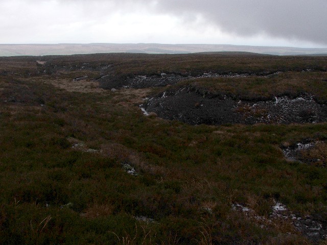
Heathfield is a hamlet in the civil parish of Stonebeck Down in upper Nidderdale, in North Yorkshire, England. It lies on a broad terrace on the west side of the dale, overlooking a steep slope down to the River Nidd. Heathfield was first recorded in Domesday Book as ''Higrefeld''. The name is derived from Old English, and means "open land frequented by jays". By the 17th century the name had become ''Hearfield'', and in the 18th century was recorded as Heathfield. In the Middle Ages the land was owned by Byland Abbey, which mined lead and established a grange there. Heathfield Moor rises west of the hamlet, and is managed for grouse shooting Driven grouse shooting is the hunting of the red grouse, a field sport of the United Kingdom. The grouse-shooting season extends from 12 August, often called the "Glorious Twelfth", to 10 December each year. Large numbers of grouse are driven to .... References External links {{authority control Villages in North Yorkshire N ... [...More Info...] [...Related Items...] OR: [Wikipedia] [Google] [Baidu] |
Stonebeck Down
Stonebeck Down is a civil parish in Harrogate district, North Yorkshire, England. The main settlements in the parish are the village of Ramsgill and the hamlets of Stean and Heathfield. The population of the parish in the 2011 census was 192. The parish occupies the west side of upper Nidderdale. It is bounded on the north by Stean Beck, from which the parish takes its name (''stean'' being a dialect form of "stone"), and which separates it from the parish of Stonebeck Up. To the west it is bounded by the ridge separating Nidderdale from Wharfedale, to the south by Ashfold Gill, separating the parish from Bewerley, and to the east by the River Nidd and Gouthwaite Reservoir, which separate the parish from Fountains Earth. The parish includes large areas of grouse moor, rising to the remote peak of Meugher. Historically Stonebeck Down was a township in the ancient parish of Kirkby Malzeard in the West Riding of Yorkshire. In the Middle Ages, it formed part of the lands of ... [...More Info...] [...Related Items...] OR: [Wikipedia] [Google] [Baidu] |
North Yorkshire (district)
North Yorkshire is a unitary authority area in the ceremonial county of North Yorkshire, Yorkshire and the Humber, England. It covers seven former districts: Craven, Hambleton, Harrogate, Scarborough, Richmondshire, Ryedale and Selby. The district has an area of , and, with the City of York and the boroughs of Middlesbrough, Redcar and Cleveland and Stockton-on-Tees (south of the River Tees), forms the ceremonial county of North Yorkshire. It is governed by North Yorkshire Council. History The district was created on 1 April 2023, following the merger of the above boroughs and districts as part of the 2019–2023 structural changes to local government in England. Geography The district has multiple hamlets and villages. Larger towns and settlements include Harrogate, Scarborough, Northallerton, Selby, Skipton, Richmond, Malton, Thirsk, Stokesley, Great Ayton, Norton-on-Derwent, Catterick Garrison, Pickering, Helmsley and Knaresborough while Ripon is the only city in t ... [...More Info...] [...Related Items...] OR: [Wikipedia] [Google] [Baidu] |
North Yorkshire
North Yorkshire is the largest ceremonial counties of England, ceremonial county (lieutenancy area) in England, covering an area of . Around 40% of the county is covered by National parks of the United Kingdom, national parks, including most of the Yorkshire Dales and the North York Moors. It is one of four counties in England to hold the name Yorkshire; the three other counties are the East Riding of Yorkshire, South Yorkshire and West Yorkshire. North Yorkshire may also refer to a non-metropolitan county, which covers most of the ceremonial county's area () and population (a mid-2016 estimate by the Office for National Statistics, ONS of 602,300), and is administered by North Yorkshire County Council. The non-metropolitan county does not include four areas of the ceremonial county: the City of York, Middlesbrough, Redcar and Cleveland and the southern part of the Borough of Stockton-on-Tees, which are all administered by Unitary authorities of England, unitary authorities. ... [...More Info...] [...Related Items...] OR: [Wikipedia] [Google] [Baidu] |
Skipton And Ripon (UK Parliament Constituency)
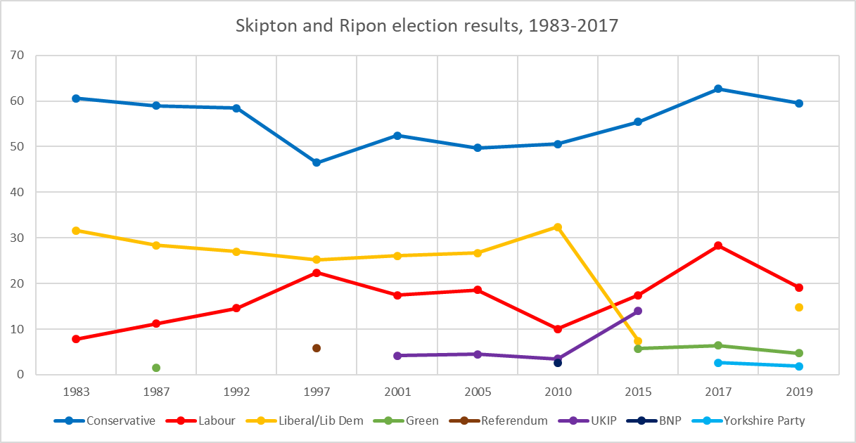
Skipton and Ripon is a constituency in North Yorkshire represented in the House of Commons of the UK Parliament since 2010 by Julian Smith, a Conservative. Constituency profile The constituency covers a mainly rural area of the Yorkshire Dales. The largest settlements are the town of Skipton and the city of Ripon. Smaller towns in the constituency are Bentham, Settle, Pateley Bridge and Masham. It is one of the safest seats in England, formed on an area with a long history of Conservative representation and with a large majority of its electorate having in the last election voted Conservative. It was also the constituency in 1992 that when declared, saw the Conservatives gain the 4th straight majority since 1979 and John Major re-elected as Prime Minister. At 1.6%, Skipton and Ripon had significantly lower than national average unemployment (3.8%) in November 2012. Boundaries 1983–1997: The District of Craven, and the Borough of Harrogate wards of Almscliffe, Bishop ... [...More Info...] [...Related Items...] OR: [Wikipedia] [Google] [Baidu] |
Nidderdale
Nidderdale, historically also known as Netherdale, is one of the Yorkshire Dales (although outside the Yorkshire Dales National Park) in North Yorkshire, England. It is the upper valley of the River Nidd, which flows south underground and then along the dale, forming several reservoirs including the Gouthwaite Reservoir, before turning east and eventually joining the River Ouse. The only town in the dale is Pateley Bridge. Other settlements include Wath, Ramsgill, Lofthouse, and Middlesmoor above Pateley Bridge, and Bewerley, Glasshouses, Summerbridge, Dacre, Darley, Birstwith, Hampsthwaite and Kettlesing below Pateley. Area of Outstanding Natural Beauty Nidderdale was designated an Area of Outstanding Natural Beauty in 1994. The AONB covers a much wider area than Nidderdale. In addition to Nidderdale itself (above Hampsthwaite), the AONB includes part of lower Wharfedale, the Washburn valley and part of lower Wensleydale, including Jervaulx Abbey and the side v ... [...More Info...] [...Related Items...] OR: [Wikipedia] [Google] [Baidu] |
River Nidd
The River Nidd is a tributary of the River Ouse in the English county of North Yorkshire. In its first few miles it is dammed three times to create Angram Reservoir, Scar House Reservoir and Gouthwaite Reservoir, which attract a total of around 150,000 visitors a year. The Nidd can overflow the reservoirs, flooding the caves in the valley. In such cases the river overflows into the normally dry river bed past Lofthouse through to Gouthwaite Reservoir. The Yorkshire Dales Rivers TrusYDRThas a remit to conserve the ecological condition of the River Nidd from its headwaters to the Humber estuary. The upper river valley, Nidderdale, was designated as an Area of Outstanding Natural Beauty in 1994. Course The Nidd rises in Nidderdale at Nidd Head Spring on the slopes of Great Whernside in the Yorkshire Dales. It flows east into Angram and Scar House reservoirs before turning south just downstream of Newhouses. In dry conditions the river disappears underground into the sinkhole kn ... [...More Info...] [...Related Items...] OR: [Wikipedia] [Google] [Baidu] |
Domesday Book
Domesday Book () – the Middle English spelling of "Doomsday Book" – is a manuscript record of the "Great Survey" of much of England and parts of Wales completed in 1086 by order of King William I, known as William the Conqueror. The manuscript was originally known by the Latin name ''Liber de Wintonia'', meaning "Book of Winchester", where it was originally kept in the royal treasury. The '' Anglo-Saxon Chronicle'' states that in 1085 the king sent his agents to survey every shire in England, to list his holdings and dues owed to him. Written in Medieval Latin, it was highly abbreviated and included some vernacular native terms without Latin equivalents. The survey's main purpose was to record the annual value of every piece of landed property to its lord, and the resources in land, manpower, and livestock from which the value derived. The name "Domesday Book" came into use in the 12th century. Richard FitzNeal wrote in the ''Dialogus de Scaccario'' ( 1179) that the book ... [...More Info...] [...Related Items...] OR: [Wikipedia] [Google] [Baidu] |
Old English Language
Old English (, ), or Anglo-Saxon, is the earliest recorded form of the English language, spoken in England and southern and eastern Scotland in the early Middle Ages. It was brought to Great Britain by Anglo-Saxon settlers in the mid-5th century, and the first Old English literary works date from the mid-7th century. After the Norman conquest of 1066, English was replaced, for a time, by Anglo-Norman (a relative of French) as the language of the upper classes. This is regarded as marking the end of the Old English era, since during this period the English language was heavily influenced by Anglo-Norman, developing into a phase known now as Middle English in England and Early Scots in Scotland. Old English developed from a set of Anglo-Frisian or Ingvaeonic dialects originally spoken by Germanic tribes traditionally known as the Angles, Saxons and Jutes. As the Germanic settlers became dominant in England, their language replaced the languages of Roman Britain: Common Br ... [...More Info...] [...Related Items...] OR: [Wikipedia] [Google] [Baidu] |
Byland Abbey
Byland Abbey is a ruined abbey and a small village in the Ryedale district of North Yorkshire, England, in the North York Moors National Park. History It was founded as a Savigniac abbey in January 1135 and was absorbed by the Cistercian order in 1147. It was not an easy start for the community which had had to move five times before settling at New Byland, near Coxwold in 1177. Its early history was marked by disputes with no fewer than four other religious establishments: Furness Abbey, Calder Abbey, Rievaulx Abbey and Newburgh Priory. However, once it had overcome these setbacks, it was described, in the late 14th century, as "one of the three shining lights of the north". Its financial success was not as great as such abbeys as Rievaulx, but it was famed for its sheep rearing and wool exports. Its church was said to be among the finest 12th-century churches in Europe. In October 1322, King Edward II was at Byland Abbey when the Battle of Old Byland took place. The maraudin ... [...More Info...] [...Related Items...] OR: [Wikipedia] [Google] [Baidu] |
Monastic Grange
Monastic granges were outlying landholdings held by monasteries independent of the manorial system. The first granges were owned by the Cistercians and other orders followed. Wealthy monastic houses had many granges, most of which were largely agricultural providing food for the monastic community. A grange might be established adjacent to the monastery but others were established wherever it held lands, some at a considerable distance. Some granges were worked by lay-brothers belonging to the order, others by paid labourers. Granges could be of six known types: agrarian, sheep or cattle farms, horse studs, fisheries and industrial complexes. Industrial granges were significant in the development of medieval industries, particularly iron working. Description Granges were landed estates used for food production, centred on a farm and out-buildings and possibly a mill or a tithe barn. The word grange comes through French from Latin meaning a granary. The granges might be locate ... [...More Info...] [...Related Items...] OR: [Wikipedia] [Google] [Baidu] |
Grouse Shooting
Driven grouse shooting is the hunting of the red grouse, a field sport of the United Kingdom. The grouse-shooting season extends from 12 August, often called the "Glorious Twelfth", to 10 December each year. Large numbers of grouse are driven to fly over people with shotguns. Driven grouse shooting first appeared around 1850 and became popular in the later Victorian era as a fashionable sport for the wealthy. The expanding rail network allowed relatively easy access into the remote upland areas of Britain for the first time and driven grouse shooting developed in tandem with this by providing shooting in a convenient and reliable form. Large numbers of birds are driven over a fixed position providing a regular supply of fast moving targets without the need to seek out the birds. The development of the breech-loading shotgun was also an essential ingredient in the development of the practice as it allowed more rapid reloading in the field matching the availability of target birds. ... [...More Info...] [...Related Items...] OR: [Wikipedia] [Google] [Baidu] |
Villages In North Yorkshire
A village is a clustered human settlement or community, larger than a hamlet but smaller than a town (although the word is often used to describe both hamlets and smaller towns), with a population typically ranging from a few hundred to a few thousand. Though villages are often located in rural areas, the term urban village is also applied to certain urban neighborhoods. Villages are normally permanent, with fixed dwellings; however, transient villages can occur. Further, the dwellings of a village are fairly close to one another, not scattered broadly over the landscape, as a dispersed settlement. In the past, villages were a usual form of community for societies that practice subsistence agriculture, and also for some non-agricultural societies. In Great Britain, a hamlet earned the right to be called a village when it built a church. [...More Info...] [...Related Items...] OR: [Wikipedia] [Google] [Baidu] |


