|
Hawd
The Haud (also Hawd) (, ), formerly known as the Hawd Reserve Area is a plateau situated in the Horn of Africa consisting of thorn-bush and grasslands. The region includes the southern part of Somaliland as well as the northern and eastern parts of the Somali Region of Ethiopia. Haud is a historic region as well as an important grazing area and has multiple times been referenced in countless notorious poems. The region is also notorious for its red soil, caused by the soil's iron richness. The Haud covers an estimated area of about 119,000 square km (or 46,000 square miles), more than nine-tenths the size of England, or roughly the size of North Korea. Overview The Haud is of indeterminate extent; some authorities consider it denotes the part of Ethiopia east of the city of Harar. I.M. Lewis provides a much more detailed description, indicating that it reaches south from the foothills of the Golis and Ogo Mountains. "The northern and eastern tips lie within the Somali Republic, wh ... [...More Info...] [...Related Items...] OR: [Wikipedia] [Google] [Baidu] |
Somaliland
Somaliland,; ar, صوماليلاند ', ' officially the Republic of Somaliland,, ar, جمهورية صوماليلاند, link=no ''Jumhūrīyat Ṣūmālīlānd'' is a ''de facto'' sovereign state in the Horn of Africa, still considered internationally to be part of Somalia. Somaliland lies in the Horn of Africa, on the southern coast of the Gulf of Aden. It is bordered by Djibouti to the northwest, Ethiopia to the south and west, and Somalia to the east.Encyclopædia Britannica, ''The New Encyclopædia Britannica'', (Encyclopædia Britannica: 2002), p.835 Its claimed territory has an area of , with approximately 5.7 million residents as of 2021. The capital and largest city is Hargeisa. The government of Somaliland regards itself as the successor state to British Somaliland, which, as the briefly independent State of Somaliland, united in 1960 with the Trust Territory of Somaliland (the former Italian Somaliland) to form the Somali Republic.''The New Encyclopædia Br ... [...More Info...] [...Related Items...] OR: [Wikipedia] [Google] [Baidu] |
Marodi Jeh
Marodi Jeh ( so, Maroodi Jeex, ar, مرودي جيح) is an administrative region ('' gobol'') in western Somaliland. It is the most populous region of the country. It is bordered by Awdal to the west, Sahil to the north, Togdheer to the east and Ethiopia to the south. Marodi Jeh was created by splitting the previously existing region (gobolka) Woqooyi Galbeed in two, the other part being Sahil. In 2007 the region of Woqooyi Galbeed was renamed to Maroodi Jeex (Chapter 1, Article 2 3 ]). Woqooyi Galbeed was thus much larger than Marodi Jeh. Etymology The Marodi Jeh region (meaning split elephant in Somali language, Somali) corresponds with the historical name of the Tog Maroodi Jeex, a seasonal river that flows through the region during the rainy season: Hargeisa is situated on the Tug Marodijeh, the banks of which are well wooded, and as it can boast of an excellent climate all the year round, and is about half-way on the main route from Bulhar to Jig-jigga on the Ab ... [...More Info...] [...Related Items...] OR: [Wikipedia] [Google] [Baidu] |
Danot (woreda)
Danot () is one of the woredas in the Somali Region of Ethiopia, named after its major town, Danot. Part of the Werder Zone, Danot is bordered on the south by Werder, on the west by the Korahe Zone, on the northwest by the Degehabur Zone, on the north by Somaliland, on the east by Boh, and on the southeast by Galadi. Overview Danot was important locally for its wells, which were used by the nomadic pastoralists with the advent of the dry season. However, the construction of private ''birkas'' (underground concrete water tanks) in adjacent woredas, a development which started in the 1950s and later on dramatically increased after the 1970s, offered a solution to the absence of permanent water, and reduced somewhat the importance of these wells. While this encouraged ''birka'' owners to further diversify traditional animal husbandry beyond camels and small ruminants into water-dependent cattle, this also increased livestock population in an overpopulated region, putting additiona ... [...More Info...] [...Related Items...] OR: [Wikipedia] [Google] [Baidu] |
Abdillahi Deria
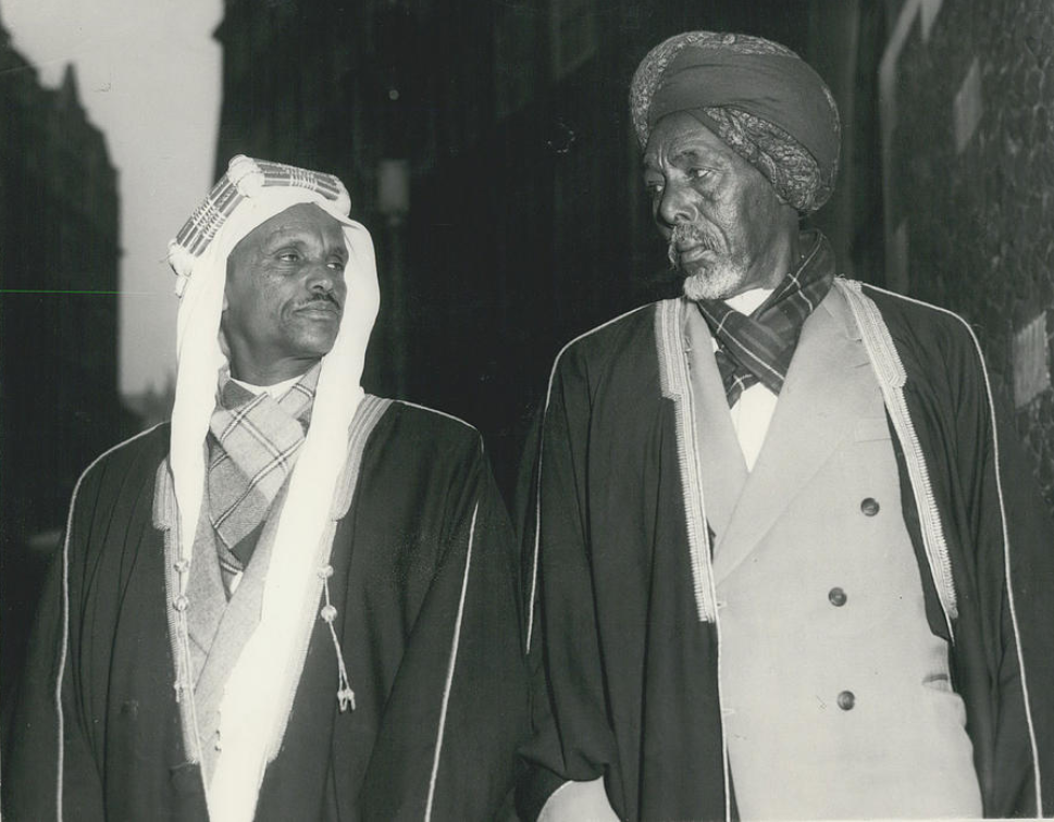
Sultan Abdillahi Deria ( so, Cabdillaahi Diiriye, ar, عبدالله بن ديريه) was the fifth Grand Sultan of the Isaaq Sultanate and a notable Somali anti-colonial figure. Biography Abdillahi was the son of Sultan Deria Hassan whom he succeeded. A member of the Eidagale sub-division of the Garhajis subclan, his reign covered the later years of British Somaliland and most of the subsequent Somali Republic. Somali National League Sultan Abdillahi was a vehement anti-colonialist and was a prominent member of the ''Somali National League'' the dominant party in the protectorate. He directly encouraged agitation and petitions by local British Somaliland communities to file with authorities. He would soon become the Secretary General of the party and one of its critical tasks was resolving the Haud dispute. Haud Delegation In response to the cessation of Haud Reserve and the Ogaden regions to Ethiopia in the year 1948, Abdillahi led a delegation of politicians and Sultans t ... [...More Info...] [...Related Items...] OR: [Wikipedia] [Google] [Baidu] |
Isaaq Sultanate
The Isaaq Sultanate ( so, Saldanadda Isaaq, Wadaad: , ar, السلطنة الإسحاقية) was a Somali kingdom that ruled parts of the Horn of Africa during the 18th and 19th centuries. It spanned the territories of the Isaaq clan in modern-day Somaliland and Ethiopia. The sultanate was governed by the Rer Guled branch of the Eidagale clan and is the pre-colonial predecessor to the modern Republic of Somaliland. History Origins According to oral tradition, prior to the Guled Dynasty the Isaaq clan-family were ruled by a dynasty of the Tolje'lo branch starting from, descendants of Ahmed nicknamed Tol Je'lo, the eldest son of Sheikh Ishaaq's Harari wife. There were eight Tolje'lo rulers in total, starting with Boqor Harun () who ruled the Isaaq Sultanate for centuries starting from the 13th century. The last Tolje'lo ruler Garad Dhuh Barar ( so, Dhuux Baraar) was overthrown by a coalition of Isaaq clans. The once strong Tolje'lo clan were scattered and took refuge amongst t ... [...More Info...] [...Related Items...] OR: [Wikipedia] [Google] [Baidu] |
Menelik II
, spoken = ; ''djānhoi'', lit. ''"O steemedroyal"'' , alternative = ; ''getochu'', lit. ''"Our master"'' (pl.) Menelik II ( gez, ዳግማዊ ምኒልክ ; horse name Abba Dagnew (Amharic: አባ ዳኘው ''abba daññäw''); 17 August 1844 – 12 December 1913), baptised as Sahle Maryam (ሣህለ ማርያም ''sahlä maryam'') was King of Shewa from 1866 to 1889 and Emperor of Ethiopia from 1889 to his death in 1913. At the height of his internal power and external prestige, the process of territorial expansion and creation of the modern empire-state was completed by 1898.Zewde, Bahru. A history of Ethiopia: 1855–1991. 2nd ed. Eastern African studies. 2001 The Ethiopian Empire was transformed under Emperor Menelik: the major signposts of modernisation were put in place, with the assistance of key ministerial advisors. Externally, Menelik led Ethiopian troops against Italian invaders in the First Italo-Ethiopian War; following a decisive victory at the Battle ... [...More Info...] [...Related Items...] OR: [Wikipedia] [Google] [Baidu] |
Anglo-Ethiopian Treaty Of 1897
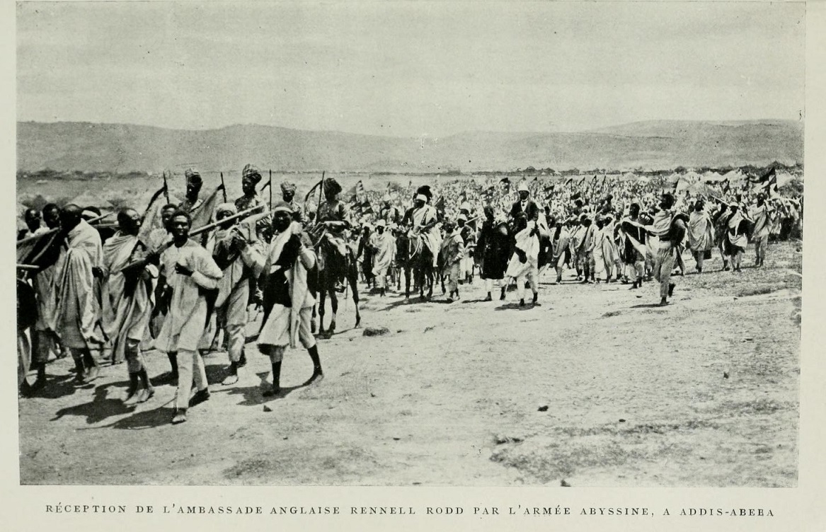
The Anglo-Ethiopian Treaty of 1897 (sometimes called the Rodd Treaty) was an agreement negotiated between diplomat Sir Rennell Rodd of the United Kingdom of Great Britain and Ireland and Emperor Menelik II of Ethiopia primarily involving border issues between Ethiopia and British Somaliland. It was signed on 14 May 1897 in order to "strengthen and render more effective and profitable the friendship between the two kingdoms", according to its preamble. The treaty consisted of several articles, including: * Article I: allowed subjects from Ethiopia and British Somaliland to have full liberties in regards to commerce with each other. * Article II: defined the geographical boundaries between Ethiopia and British Somaliland. * Article III: specified keeping open the caravan route between Harar and the colonial port of Zeila. * Article IV: Ethiopia granted Great Britain favoured rights in respect to import duties and taxes. * Article V: allowed Ethiopian import of military equipment thr ... [...More Info...] [...Related Items...] OR: [Wikipedia] [Google] [Baidu] |
Somali Ostrich
The Somali ostrich (''Struthio molybdophanes''), also known as the blue-necked ostrich, is a large flightless bird native to the Horn of Africa. It is one of two living species of ostriches, the other being the common ostrich. It was also previously considered a subspecies of the common ostrich, but was identified as a distinct species in 2014. Taxonomy and systematics ''Struthio molybdophanes'' was first described in the '' Norddeutsche allgemeine Zeitung'' Sunday Supplement of 16 September 1883 by Anton Reichenow, who noted the ostrich's distribution as extending over the plains of Somali- and western Galla-Land on the east coast of Africa from 10 degrees north to the Equator. Molecular evidence indicates that the East African Rift has served as a geographic barrier to isolate the taxon from the nominate subspecies, the North African ostrich ''S. c. camelus'', while ecological and behavioural differences have kept it genetically distinct from the neighbouring Masai ostr ... [...More Info...] [...Related Items...] OR: [Wikipedia] [Google] [Baidu] |
Somali Language
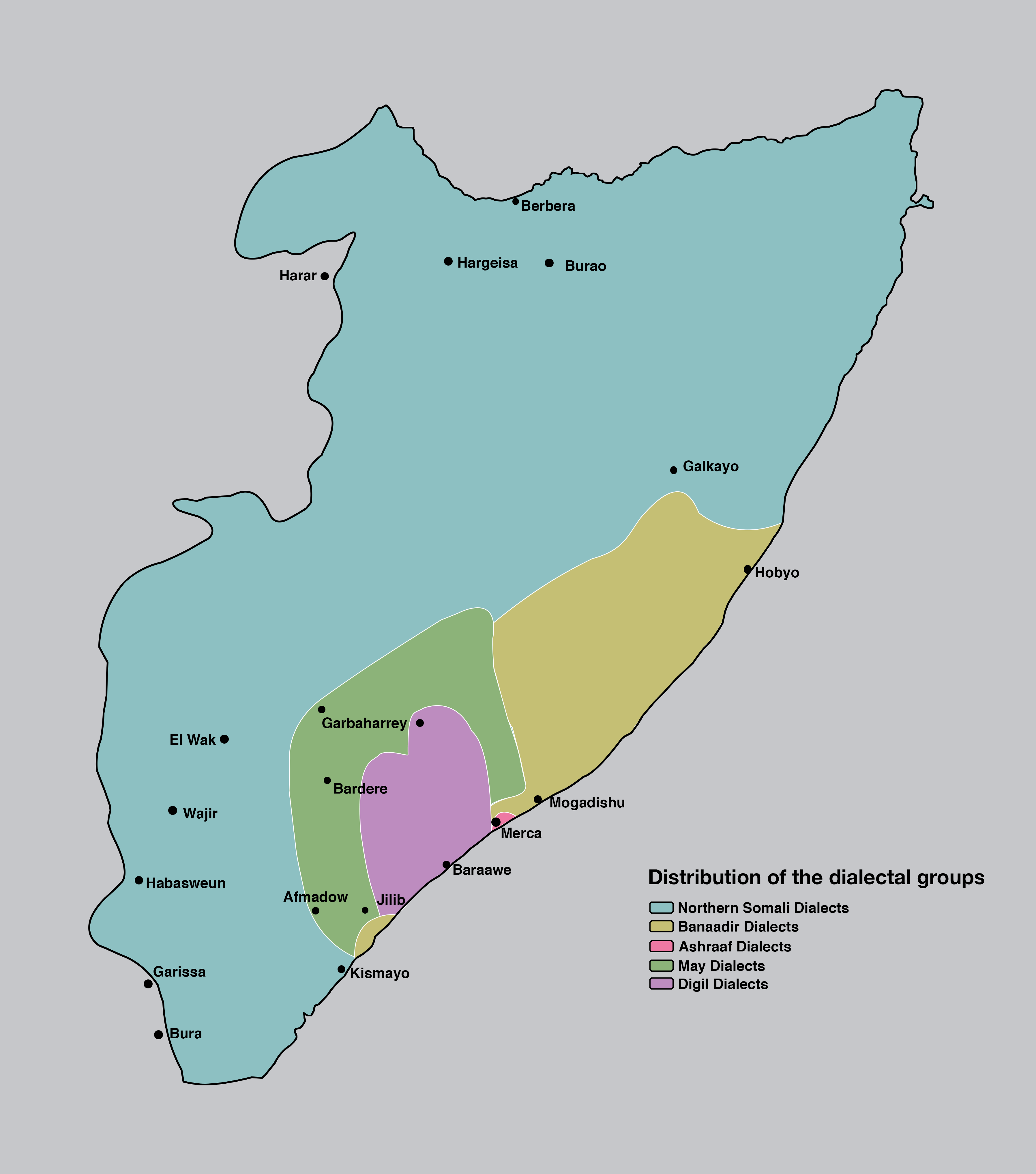
Somali (Latin script: ; Wadaad writing, Wadaad: ; Osmanya: 𐒖𐒍 𐒈𐒝𐒑𐒛𐒐𐒘 ) is an Afroasiatic languages, Afroasiatic language belonging to the Cushitic languages, Cushitic branch. It is spoken as a mother tongue by Somalis in Greater Somalia and the Somali diaspora. Somali is an official language in Somalia and Ethiopia, and a national language in Djibouti as well as in northeastern Kenya. The Somali language is written officially with the Somali Latin alphabet, Latin alphabet although the Arabic alphabet and several Somali scripts like Osmanya script, Osmanya, Kaddare script, Kaddare and the Gadabuursi Somali Script, Borama script are informally used.Lewis, I.M. (1958)The Gadabuursi Somali Script ''Bulletin of the School of Oriental and African Studies'', University of London, Vol. 21, pp. 134–156. Classification Somali is classified within the Cushitic branch of the Afroasiatic family, specifically, Lowland East Cushitic languages, Lowland East Cushitic in ... [...More Info...] [...Related Items...] OR: [Wikipedia] [Google] [Baidu] |
Anhydrite
Anhydrite, or anhydrous calcium sulfate, is a mineral with the chemical formula CaSO4. It is in the orthorhombic crystal system, with three directions of perfect cleavage parallel to the three planes of symmetry. It is not isomorphous with the orthorhombic barium ( baryte) and strontium ( celestine) sulfates, as might be expected from the chemical formulas. Distinctly developed crystals are somewhat rare, the mineral usually presenting the form of cleavage masses. The Mohs hardness is 3.5, and the specific gravity is 2.9. The color is white, sometimes greyish, bluish, or purple. On the best developed of the three cleavages, the lustre is pearly; on other surfaces it is glassy. When exposed to water, anhydrite readily transforms to the more commonly occurring gypsum, (CaSO4·2H2O) by the absorption of water. This transformation is reversible, with gypsum or calcium sulfate hemihydrate forming anhydrite by heating to around under normal atmospheric conditions. Anhydrite is comm ... [...More Info...] [...Related Items...] OR: [Wikipedia] [Google] [Baidu] |
Limestone
Limestone ( calcium carbonate ) is a type of carbonate sedimentary rock which is the main source of the material lime. It is composed mostly of the minerals calcite and aragonite, which are different crystal forms of . Limestone forms when these minerals precipitate out of water containing dissolved calcium. This can take place through both biological and nonbiological processes, though biological processes, such as the accumulation of corals and shells in the sea, have likely been more important for the last 540 million years. Limestone often contains fossils which provide scientists with information on ancient environments and on the evolution of life. About 20% to 25% of sedimentary rock is carbonate rock, and most of this is limestone. The remaining carbonate rock is mostly dolomite, a closely related rock, which contains a high percentage of the mineral dolomite, . ''Magnesian limestone'' is an obsolete and poorly-defined term used variously for dolomite, for limes ... [...More Info...] [...Related Items...] OR: [Wikipedia] [Google] [Baidu] |


