|
Hatiya, Bangladesh
Hatiya () is an upazila (sub-district) of Noakhali District in Bangladesh's Chittagong Division. It encompasses of a small archipelago in southeastern Noakhali, most notably Hatiya Island, Nijhum Dwip, Domar Char, Kolatoli Char, Bhasan Char and Swarna Dweep. History thumbnail, left, 250px, Hatiya Island in 1778 in a map by James Rennell The Hatiya thana was established with Hatiya Island as its largest and principal island. In 1983, Hatiya Thana was upgraded to an upazila (sub-district) as part of the President of Bangladesh Hussain Muhammad Ershad's decentralisation programme. Power House Hatia-Nijhum Island is being illuminated with electricity at a cost of Tk 400 crore. After 50 years, 30,000 customers are being connected to electricity services in the form of 15 MW power plants. It is learned that the cost of this project will be 364 crore 36 lakh 15 thousand taka. Geography Hatiya Upazila is located at . It has 47,970 household units and a total area of 2,100 sq ... [...More Info...] [...Related Items...] OR: [Wikipedia] [Google] [Baidu] |
Upazila
An ''upazila'' ( pronounced: ), formerly called ''thana'', is an administrative division in Bangladesh, functioning as a sub-unit of a district. It can be seen as an analogous to a county or a borough of Western countries. Rural upazilas are further administratively divided into union council areas (union parishads). Bangladesh has 495 upazilas. The upazilas are the second lowest tier of regional administration in Bangladesh. The administrative structure consists of divisions (8), districts (64), upazilas (495) and union parishads (UPs). This system of devolution was introduced by the former military ruler and president of Bangladesh, Lt-Gen Hossain Muhammad Ershad, in an attempt to strengthen local government. Below UPs, villages (''gram'') and ''para'' exist, but these have no administrative power and elected members. The Local Government Ordinance of 1982 was amended a year later, redesignating and upgrading the existing ''thanas'' as ''upazilas''. History Upa ... [...More Info...] [...Related Items...] OR: [Wikipedia] [Google] [Baidu] |
Hinduism In Bangladesh
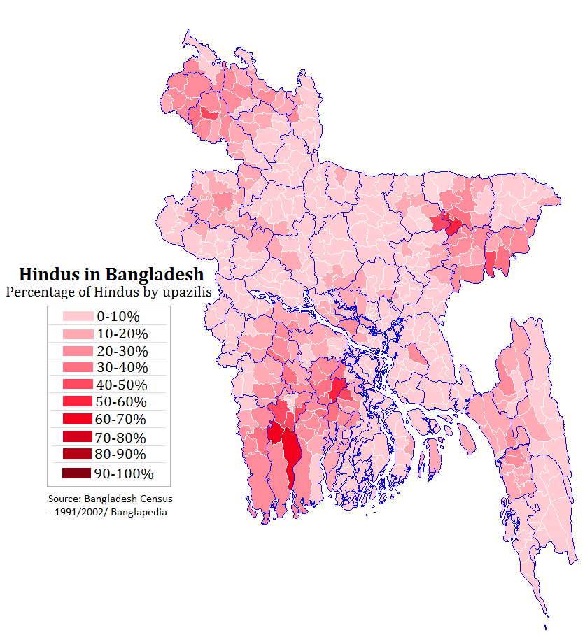
Hinduism is the second largest religion in Bangladesh, as according to the 2022 Census of Bangladesh, approximately 13.1 million people responded as Hindus, constituting 7.95% of the nation. Bangladesh is the third-largest Hindu populated country in the world, after India and Nepal. Hinduism is the Religion in Bangladesh, second-largest religion in 61 of 64 districts in Bangladesh, but there are no Hindu majority districts in Bangladesh. Demographics According to the 2001 Bangladesh census, there were around 11.82 million Hindus in Bangladesh constituting 9.6% of the population, which at the time was 123.15 million. The 2011 Bangladesh census, Bangladesh 2011 census states, that approximately 12.73 million people responded that they were Hindus, constituting 8.54% of the total 149.77 million. While 2022 Census of Bangladesh, put the number of Hindus in Bangladesh at 13.1 million out of total 165.1 million population, thus constituting 7.95% of the population. According to ... [...More Info...] [...Related Items...] OR: [Wikipedia] [Google] [Baidu] |
Islam In Bangladesh
Islam is the largest and the state religion of the People's Republic of Bangladesh. According to the 2022 census, Bangladesh had a population of about 150 million Muslims, or 91.04% of its total population of million. Muslims of Bangladesh are predominant native Bengali Muslims. The majority of Bangladeshis are ''Sunni'', and follow the '' Hanafi'' school of ''Fiqh''. Bangladesh is a ''de facto'' secular country. The Bengal region was a supreme power of the medieval Islamic East. In the late 7th century, Muslims from Arabia established commercial as well as religious connection within the Bengal region before the conquest, mainly through the coastal regions as traders and primarily via the ports of Chittagong. In the early 13th century, Muhammad bin Bakhtiyar Khalji conquered Western and part of Northern Bengal and established the first Muslim kingdom in Bengal. During the 13th century, Sufi missionaries, mystics and saints began to preach Islam in villages. The Islamic ... [...More Info...] [...Related Items...] OR: [Wikipedia] [Google] [Baidu] |
Manpura Upazila
Manpura () is an upazila of Bhola District in the Division of Barisal, Bangladesh. Geography thumbnail, left, 250px, Manpura Island (marked as Moncoorah I.) in 1778 map by James Rennell Manpura is located at . It has 8,959 households and a total area of 373.19 km2. It is bounded by Tazumuddin upazila on the north, Bay of Bengal on the south, Hatiya upazila on the east, Lalmohan and Char Fasson upazilas on the west. Demographics As of the 2011 Census of Bangladesh, Manpura has a population of 76,582 living in 17,080 households. 22,066 (28.81%) were under 10 years of age. Manpura has an average literacy rate of 32.10% (7+ years) and a sex ratio of 977 females per 1000 males. 1,023 (1.34%) of the population lives in urban areas. According to the 2001 Bangladesh census, Manpura had a population of 67,304. Males constituted 51.63% of the population, and females 48.37%. The population aged 18 or over was 20,940. Manpura had an average literacy rate of 21.3% (7+ years ... [...More Info...] [...Related Items...] OR: [Wikipedia] [Google] [Baidu] |
Bay Of Bengal
The Bay of Bengal is the northeastern part of the Indian Ocean. Geographically it is positioned between the Indian subcontinent and the Mainland Southeast Asia, Indochinese peninsula, located below the Bengal region. Many South Asian and Southeast Asian Countries of the Bay of Bengal, countries are dependent on the Bay of Bengal. Geopolitically, the bay is bounded on the west and northwest by India, on the north by Bangladesh, and on the east by Myanmar and the Andaman and Nicobar Islands of India. Its southern limit is a line between Sangaman Kanda, Sri Lanka, and the northwesternmost point of Sumatra, Indonesia. Cox's Bazar Beach, Cox's Bazar, the longest sea beach in the world and Sundarbans, the largest mangrove forest and the natural habitat of the Bengal tiger, are located along the bay. The Bay of Bengal occupies an area of . A number of large rivers flow into the Bay of Bengal: the Ganges–Hooghly River, Hooghly, the Padma River, Padma, the Brahmaputra River, Brahmaputr ... [...More Info...] [...Related Items...] OR: [Wikipedia] [Google] [Baidu] |
Ramgati Upazila
Ramgati () is an upazila (sub-district) of Lakshmipur District in Bangladesh, part of the Chattogram Division. The Government of Bangladesh plans to build an airport in this upazila. History Ramgati is home to historic infrastructure such as the Bedar Bakhsh Mosque in Borokheri. The origin of Ramgati is said to have been from a man named Ramkrishna who had a large mercantile centre in the area known as a ''gôdi'' in the Bengali language. From this, the area came to be known as ''Ramer gadi'' (meaning Ram's godi) and was later corrupted into Ramgati. Initially, a thana was established in the Borokheri Union in 1862. In 1933, the Baluchar Islamia Senior Alim Madrasa was founded. Five years later, the Char Alexander Alia Madrasa opened. In 1957, the Government of Pakistan's Irrigation Department constructed the earthen 13.68km ''Meghna Cross-Dam I'' across a major branch of the Meghna River which flowed between Ramgati and the Noakhali mainland. As a result, river flow was diverted w ... [...More Info...] [...Related Items...] OR: [Wikipedia] [Google] [Baidu] |
Subarnachar Upazila
Subarnachar () is an upazila (sub-district) of Noakhali District, located in Bangladesh's Chittagong Division. The Bhulua River and Sandwip Channel flows through it. A number of Subarnachar residents have migrated to Oman where they form a small diaspora community. History The islands in the upazila formed in 1959 and many poor migrants started settling there. This was followed by a land dispute in 1986 with foreign land grabbing forces. The clashes killed hundreds of people and destroyed thousands of homes. The settlers of Subarnachar sacrificed many precious lives to survive on that day. The history of this upazila has been written through the relentless struggle of the working people who have made this salty char habitable through their creative activities. Subarnachar has suffered from flooding in many occasions such as on 12 November 1970 as well as in 1985, 1991 and 1998. Subarnachar was given upazila status on 2 April 2005, taking 7 unions from Noakhali Sadar Upazila. Demogr ... [...More Info...] [...Related Items...] OR: [Wikipedia] [Google] [Baidu] |
Hussain Muhammad Ershad
Hussain Muhammad Ershad (1 February 1930 – 14 July 2019) was a Bangladeshi military officer, dictator and politician who served as President of Bangladesh, the president of Bangladesh from 1982 to 1990. He seized power as a result of a 1982 Bangladesh coup d'état, bloodless coup against President Abdus Sattar (president), Abdus Sattar on 24 March 1982 (by imposing martial law and suspending the Constitution of Bangladesh, Constitution). He declared himself President in 1983, and subsequently won the controversial 1986 Bangladeshi presidential election. Despite claims to have legitimately won the 1986 election, many consider his regime as a military regime. Ershad founded the Jatiya Party (Ershad), Jatiya Party in 1986 and became a Member of Parliament for JP in the constituency of Rangpur-3 in 1991, with successful re-elections in all subsequent general elections. He was the longest serving male head of government in Bangladeshi history. During his tenure, Ershad pursued dev ... [...More Info...] [...Related Items...] OR: [Wikipedia] [Google] [Baidu] |
President Of Bangladesh
President of Bangladesh (POB), officially the President of the People's Republic of Bangladesh, is the head of state of Bangladesh and commander-in-chief of the Bangladesh Armed Forces. The role of the president has changed three times since Bangladesh achieved its Independence of Bangladesh, independence in Bangladesh Liberation War, 1971. Presidents had been given executive power. In 1991, with the restoration of a democratically elected government, Bangladesh adopted a parliamentary democracy based on a Westminster system. The President is now a largely ceremonial post, elected by the Parliament."Background Note: Bangladesh" US Department of State, May 2007 In 1996, Parliament passed new laws enhancing the president's executive authority, as laid down in the constitution, after the Parli ... [...More Info...] [...Related Items...] OR: [Wikipedia] [Google] [Baidu] |
Thana
Thana means " station" or "place" in South Asian countries. The word ''thana'' originates from the Sanskrit word ''sthana'' or "sthanak", meaning "place" or "stand", which was anglicized as ''thana'' by the British. * Thanas of Bangladesh, former subdistricts in the administrative geography of Bangladesh; later renamed ''upazila'' * in (British) Indian history, a ''thana'' was a group of princely states deemed too small to perform all functions separately *Thane is a city named after the word ''sthana'' (station), and is located in the Konkan division, a province of India * Thana Bhawan (), also known simply as Thana, is a town in Uttar Pradesh, India See also * * {{wikt-inline, thana * Tana (other) * Thaana Thaana, Tãna, Taana or Tāna ( ) is the present writing system of the Maldivian language spoken in the Maldives. Thaana has characteristics of both an abugida (diacritics, vowel-killer strokes) and a true alphabet (all vowels are w ..., also k ... [...More Info...] [...Related Items...] OR: [Wikipedia] [Google] [Baidu] |
The Delta Of Ganges By J
''The'' is a grammatical article in English, denoting nouns that are already or about to be mentioned, under discussion, implied or otherwise presumed familiar to listeners, readers, or speakers. It is the definite article in English. ''The'' is the most frequently used word in the English language; studies and analyses of texts have found it to account for seven percent of all printed English-language words. It is derived from gendered articles in Old English which combined in Middle English and now has a single form used with nouns of any gender. The word can be used with both singular and plural nouns, and with a noun that starts with any letter. This is different from many other languages, which have different forms of the definite article for different genders or numbers. Pronunciation In most dialects, "the" is pronounced as (with the voiced dental fricative followed by a schwa) when followed by a consonant sound, and as (homophone of the archaic pronoun ''thee' ... [...More Info...] [...Related Items...] OR: [Wikipedia] [Google] [Baidu] |


