|
Harsimus Stem Embankment
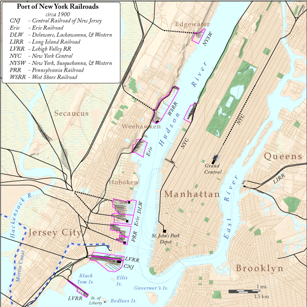
The Harsimus Stem Embankment, also called Sixth Street Embankment, is a half-mile-long historic railroad embankment, now abandoned and largely overgrown with foliage, in the heart of the historic downtown of Jersey City, New Jersey in the United States. The embankment runs along the south side of Sixth Street west from Marin Boulevard to Brunswick Street. It is the border between the Harsimus and Hamilton Park neighborhoods. The overhead tracks of the beam bridge west of Brunswick Street were dismantled but the stone abutments remain. This elevated stone structure once carried seven tracks of the Pennsylvania Railroad's Passaic and Harsimus Line to its freight yards and carfloat operations on the Hudson River at Harsimus Cove, and to its warehouse and distribution facility (now Harborside Financial Center). The line was part of the railroad's holdings on the waterfront, which included the Exchange Place passenger terminal and the Greenville Yard. The Embankment is li ... [...More Info...] [...Related Items...] OR: [Wikipedia] [Google] [Baidu] |
Exchange Place (PRR Station)
The Pennsylvania Railroad Station was the intermodal passenger terminal for the Pennsylvania Railroad's (PRR) vast holdings on the Hudson River and Upper New York Bay in Jersey City, New Jersey. By the 1920s the station was called Exchange Place. The rail terminal and its ferry slips were the main New York City station for the railroad until the opening in 1910 of New York Pennsylvania Station, made possible by the construction of the North River Tunnels. It was one of the busiest stations in the world for much of the 19th century. The terminal was on Paulus Hook, which in 1812 became the landing of the first steam ferry service in the world, and to which rail service began in 1834. Train service to the station ended in November 1961 and demolition of the complex was completed in 1963. Part of the former terminal complex is now the PATH system's Exchange Place Station while the Harborside Financial Center was built upon part of the old site. The station was one of five passe ... [...More Info...] [...Related Items...] OR: [Wikipedia] [Google] [Baidu] |
Lowline (park)
The Lowline, formerly known as the Delancey Underground, is a stalled construction project that would have become the world's first underground park in the New York City borough of Manhattan. It is located under the eastbound roadway of Delancey Street on the Lower East Side, in the former Williamsburg Bridge Trolley Terminal adjacent to the Essex Street station () and to the Essex Crossing complex. Construction of the Lowline began in 2019, but was put on hold in 2020 due to lack of funds. The name "Lowline" is a reference to the High Line, an elevated park converted from an abandoned railway. Site description Co-founders James Ramsey and Dan Barasch have suggested natural light would be directed below ground using a system that has been described in the proposed plan as " remote skylights", providing an area in which trees and grass could be grown beneath city streets. Light collectors would be placed at ground level or on surrounding rooftops, with suggested locations, i ... [...More Info...] [...Related Items...] OR: [Wikipedia] [Google] [Baidu] |
Jersey City Branch
The Pennsylvania Railroad Station was the intermodal passenger terminal for the Pennsylvania Railroad's (PRR) vast holdings on the Hudson River and Upper New York Bay in Jersey City, New Jersey. By the 1920s the station was called Exchange Place. The rail terminal and its ferry slips were the main New York City station for the railroad until the opening in 1910 of New York Pennsylvania Station, made possible by the construction of the North River Tunnels. It was one of the busiest stations in the world for much of the 19th century. The terminal was on Paulus Hook, which in 1812 became the landing of the first steam ferry service in the world, and to which rail service began in 1834. Train service to the station ended in November 1961 and demolition of the complex was completed in 1963. Part of the former terminal complex is now the PATH system's Exchange Place Station while the Harborside Financial Center was built upon part of the old site. The station was one of five pas ... [...More Info...] [...Related Items...] OR: [Wikipedia] [Google] [Baidu] |
High Line
The High Line is a elevated park, elevated linear park, greenway (landscape), greenway and rail trail created on a former New York Central Railroad spur on the West Side (Manhattan), west side of Manhattan in New York City. The High Line's design is a collaboration between James Corner, James Corner Field Operations, Diller Scofidio + Renfro, and Piet Oudolf. The abandoned spur has been redesigned as a "living system" drawing from multiple disciplines which include landscape architecture, urban design, and ecology. The High Line was inspired by the long Promenade plantée (tree-lined walkway), a similar project in Paris completed in 1993. The park is built on a disused, southern elevated railway, viaduct section of the New York Central Railroad's West Side Line. Originating in the Meatpacking District, Manhattan, Meatpacking District, the park runs from Gansevoort Street – three blocks below 14th Street (Manhattan), 14th Street – through Chelsea, Manhattan, Chelsea to ... [...More Info...] [...Related Items...] OR: [Wikipedia] [Google] [Baidu] |
Greenway, London
The Greenway is a long footpath and cycleway in London, mostly in the London Borough of Newham, on the embankment containing the Joseph Bazalgette Northern Outfall Sewer. Route The western end of the Greenway is Victoria Park, London (London Borough of Tower Hamlets). The route runs alongside Wick Lane, under the East Cross Route to Fish Island. It then crosses the River Lea into Newham, continuing to Stratford and West Ham. The eastern end is at Royal Docks Road in Beckton. The Capital Ring Walk (section 14) follows the Greenway for most of its distance, and forms part 4 of the 2012 Jubilee Greenway The western half of the Greenway embankment is roughly at house eaves height giving a view over the surrounding flat area (see gallery pictures). Between Stratford High Street and Beckton the route is flat. There is a renewed tarmac surface along its full length, with grass kept short on either side and bushes/trees on the embankment sides. The tarmac area is the width of a ... [...More Info...] [...Related Items...] OR: [Wikipedia] [Google] [Baidu] |
Bloomingdale Trail
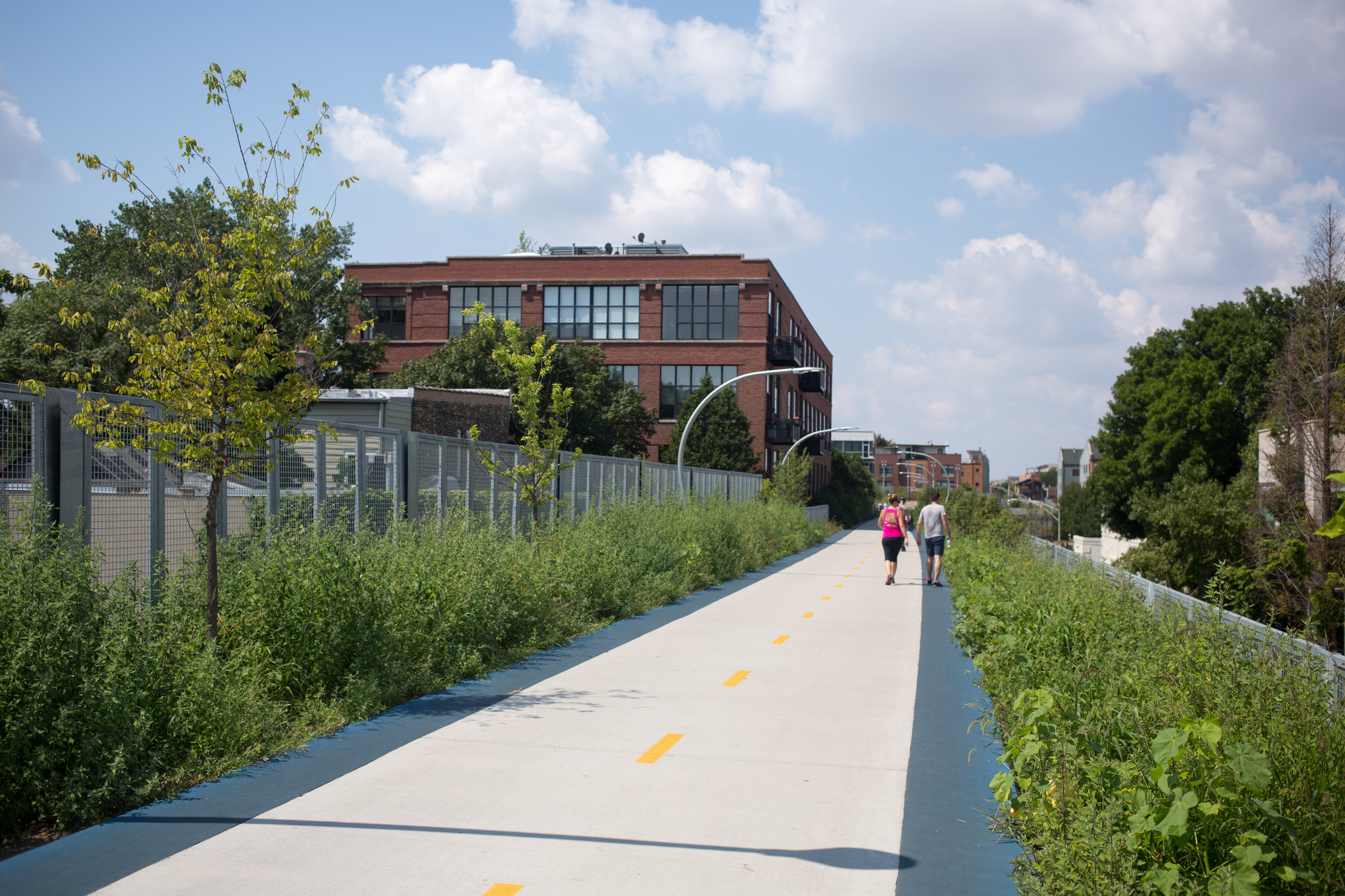
The Bloomingdale Trail is a elevated rail trail linear park running east–west on the northwest side of Chicago. It is the longest greenway project of a former elevated rail line in the Western Hemisphere, and the second longest in the world, after the Promenade plantee linear park in Paris. In 2015, the City of Chicago converted the former Bloomingdale railway line to an elevated greenway, which forms the backbone of the 606 trail network. The Bloomingdale Trail elevated park is in the Logan Square, Humboldt Park, and West Town neighborhoods. History The Bloomingdale Line was constructed in 1873 by the Chicago & Pacific Railroad Company as part of the Elgin subdivision from Halsted Street in Chicago to the suburb of Elgin, Illinois. It was soon absorbed by the Chicago, Milwaukee, St. Paul and Pacific Railway (also known as the Milwaukee Road), first via a 999-year lease in 1880 and later with a fee simple deed conveyance to the same in 1900. As a result of mergers a ... [...More Info...] [...Related Items...] OR: [Wikipedia] [Google] [Baidu] |
Bergen Hill
Bergen Hill refers to the lower Hudson Palisades in New Jersey, where they emerge on Bergen Neck, which in turn is the peninsula between the Hackensack and Hudson Rivers, and their bays. In Hudson County, it reaches a height of 260 feet. Rail Defining features of Bergen Hill include the 19th century and early 20th century railroad rights-of-way. Cuts and tunnels created to provide access to the terminals and ferries on the North River (Hudson River) and Upper New York Bay, and eventually under the river. From south to north they are: * The Central Railroad of New Jersey lines traveled on the CRRNJ Newark Bay Bridge across Newark Bay and through Bayonne and Greenville to its Communipaw Terminal. Portions are used by the Hudson Bergen Light Rail. * The Jersey City, Newark and Western Railway (later the Lehigh Valley Terminal Railway) freight line on the bridge over Newark Bay and across Pamrapo is now used by CSX Transportation as the National Docks Secondary to Port Jersey a ... [...More Info...] [...Related Items...] OR: [Wikipedia] [Google] [Baidu] |
Bergen Arches
Bergen Arches is an abandoned railroad right of way through Bergen Hill (the lower New Jersey Palisades) in Jersey City, New Jersey. History Bergen Arches is the common name for the Erie Cut, the Erie Railroad's mile-long, four-track cut which linked the railroad's main line to its Hudson River waterfront Pavonia Terminal, where travelers to Manhattan could transfer to the Pavonia Ferry or the Hudson and Manhattan Railroad. From 1906 to 1910, using 250,000 pounds of dynamite, workers blasted through of blue trap rock; of earth were excavated. There were construction cost overruns (and settlements paid to local homeowners for damage and injuries from flying rock), with a total cost around $5,000,000.00, that led to financial trouble for the Erie and the cancellation of plans to build a new terminal along the Jersey City waterfront. The term "Bergen Arches" originally referred to the massive bridges over the cut, but the two terms have become synonymous. The last trains to the ... [...More Info...] [...Related Items...] OR: [Wikipedia] [Google] [Baidu] |
Conrail
Conrail , formally the Consolidated Rail Corporation, was the primary Class I railroad in the Northeastern United States between 1976 and 1999. The trade name Conrail is a portmanteau based on the company's legal name. It continues to do business as an asset management and network services provider in three Shared Assets Areas that were excluded from the division of its operations during its acquisition by CSX Corporation and the Norfolk Southern Railway. The federal government created Conrail to take over the potentially-profitable lines of multiple bankrupt carriers, including the Penn Central Transportation Company and Erie Lackawanna Railway. After railroad regulations were lifted by the 4R Act and the Staggers Act, Conrail began to turn a profit in the 1980s and was privatized in 1987. The two remaining Class I railroads in the East, CSX Transportation and the Norfolk Southern Railway (NS), agreed in 1997 to acquire the system and split it into two roughly-equal parts (a ... [...More Info...] [...Related Items...] OR: [Wikipedia] [Google] [Baidu] |
Hudson County, New Jersey
Hudson County is the most densely populated county in the U.S. state of New Jersey. It lies west of the lower Hudson River, which was named for Henry Hudson, the sea captain who explored the area in 1609. Part of New Jersey's Gateway Region in the New York metropolitan area, the county's county seat and largest city is Jersey City,New Jersey County Map New Jersey Department of State. Accessed July 10, 2017. whose population as of the was 292,449. As of the |
New Jersey Department Of Environmental Protection
The New Jersey Department of Environmental Protection (NJDEP) is a government agency in the U.S. state of New Jersey that is responsible for managing the state's natural resources and addressing issues related to pollution. NJDEP now has a staff of approximately 2,850. The department was created on April 22, 1970, America's first official Earth Day, making it the third state in the country to combine its environmental activities into a single, unified agency, with about 1,400 employees in five divisions, charged with responsibility for environmental protection and conservation efforts. Governor William T. Cahill appointed Richard J. Sullivan as the first commissioner. In December 2017, Catherine McCabe was nominated by New Jersey governor-elect Phil Murphy to serve as Commissioner of the New Jersey Department of Environmental Protection. Shawn M. LaTourette succeeded her in January 2021. Other former Commissioners have included Lisa P. Jackson and Bradley M. Campbell. Divisions ... [...More Info...] [...Related Items...] OR: [Wikipedia] [Google] [Baidu] |


