|
Happy Valley, Blount County, Tennessee
Happy Valley is an unincorporated community in Blount County, Tennessee, United States, near the Great Smoky Mountains National Park. Although it is not a census-designated place, the ZIP Code Tabulation Area for the ZIP Code (37878) that serves Happy Valley had a population of 529 as of the 2000 U.S. Census. Geography Happy Valley is situated in a narrow valley of the same name on the northwestern fringe of the Great Smoky Mountains. Chilhowee Mountain— an elongate ridge stretching for roughly between the Little Tennessee River and the Little Pigeon River watersheds— spans Happy Valley to the north. The valley is walled off to the south by several low ridges— namely Pine Mountain to the southwest and Hatcher Mountain to the southeast— which run roughly parallel to Chilhowee Mountain. Cades Cove is located opposite Hatcher and Pine Mountain to the south. Happy Valley Ridge provides the valley's eastern barrier, splitting it off from Lake in the S ... [...More Info...] [...Related Items...] OR: [Wikipedia] [Google] [Baidu] |
Unincorporated Area
An unincorporated area is a region that is not governed by a local municipal corporation. Widespread unincorporated communities and areas are a distinguishing feature of the United States and Canada. Most other countries of the world either have no unincorporated areas at all or these are very rare: typically remote, outlying, sparsely populated or List of uninhabited regions, uninhabited areas. By country Argentina In Argentina, the provinces of Chubut Province, Chubut, Córdoba Province (Argentina), Córdoba, Entre Ríos Province, Entre Ríos, Formosa Province, Formosa, Neuquén Province, Neuquén, Río Negro Province, Río Negro, San Luis Province, San Luis, Santa Cruz Province, Argentina, Santa Cruz, Santiago del Estero Province, Santiago del Estero, Tierra del Fuego Province, Argentina, Tierra del Fuego, and Tucumán Province, Tucumán have areas that are outside any municipality or commune. Australia Unlike many other countries, Australia has only local government in Aus ... [...More Info...] [...Related Items...] OR: [Wikipedia] [Google] [Baidu] |
Chilhowee Mountain
Chilhowee Mountain is the name of two non-contiguous low ridges in the U.S. state of Tennessee. The northern section is at the outer edge of the Great Smoky Mountains, stretching between the Little Tennessee River and Chilhowee Dam to the west, and the Little Pigeon River watershed to the east. The southern section is within the outer edge of the Unicoi Mountains in Polk County. While not entirely within the Great Smoky Mountains National Park, the northernmost mountain's crest is traversed by the westernmost section of the Foothills Parkway. Background While the northern ridge is long, it rarely reaches a width of more than or . Little River cuts a large gap in the middle of the mountain (near Walland), dividing it into eastern and western sections. The highest point on the western section is at a knob known as Look Rock. The highest point on the eastern section, known as The Three Sisters, rises to , and is visible from nearby Maryville, Tennessee. The southern ridge is a ... [...More Info...] [...Related Items...] OR: [Wikipedia] [Google] [Baidu] |
Little River (Tennessee)
Little River is a river in Tennessee which drains a area containing some of the most spectacular scenery in the southeastern United States. The first of the river are all located within the borders of the Great Smoky Mountains National Park. The remaining flow out of the mountains through Blount County, Tennessee, Blount County to join the Tennessee River at Fort Loudon Lake in Knox County, Tennessee, Knox County. History, Course & Geology Source to Elkmont Little River rises in Sevier County, Tennessee, Sevier County inside the national park on the north slope of Clingmans Dome, the highest point in Tennessee. Clingmans Dome is located directly on the Tennessee-North Carolina state line, which parallels the Appalachian Trail along the crest of the Smokies. Approximately one mile below its source, Little River absorbs several smaller streams at an area known as "Three Forks", where the river gains considerable strength. From here, the river is paralleled by the well-main ... [...More Info...] [...Related Items...] OR: [Wikipedia] [Google] [Baidu] |
Chiaha
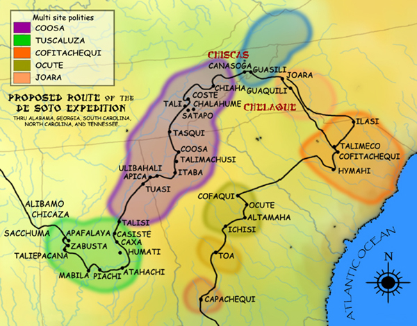
Chiaha was a Native American chiefdom located in the lower French Broad River valley in modern East Tennessee, in the southeastern United States. They lived in raised structures within boundaries of several stable villages. These overlooked the fields of maize, beans, squash, and tobacco, among other plants which they cultivated. Chiaha was the northern extreme of the paramount Coosa chiefdom's sphere of influence in the 16th century when the Spanish expeditions of Hernando de Soto and Juan Pardo passed through the area. The Chiaha chiefdom included parts of modern Jefferson and Sevier counties, and may have extended westward into Knox, Blount and Monroe counties. The Spanish explorers' accounts of Chiaha provide a rare first-hand glimpse of life in a Dallas phase Mississippian-era village. The Dallas culture, named after Dallas Island near Chattanooga, where its distinct characteristics were first observed, dominated much of East Tennessee between approximately 1300 and ... [...More Info...] [...Related Items...] OR: [Wikipedia] [Google] [Baidu] |
Coosa Chiefdom
The Coosa chiefdom was a powerful Native American paramount chiefdom in what are now Gordon and Murray counties in Georgia, in the United States."Late Prehistoric/Early Historic Chiefdoms (ca. A.D. 1300-1850)" ''''. Retrieved July 22, 2010. It was inhabited from about 1400 until about 1600, and dominated several smaller chiefdoms. The total population of Coosa's area of influence, reaching into present-day Tennessee and Alabama, has been estimated at 50,000. |
Juan Pardo (explorer)
Juan Pardo was a Spanish explorer who was active in the later half of the sixteenth century. He led a Spanish expedition from the Atlantic coast through what is now North and South Carolina and into eastern Tennessee on the orders of Pedro Menéndez de Avilés, in an attempt to find an inland route to a silver-producing town in Mexico. Menéndez had built Fort San Felipe (1566), and established Santa Elena, on present-day Parris Island; these were the first Spanish settlements in what is now South Carolina. While leading his expedition deeper into the interior, Pardo founded Fort San Juan at Joara, the first European settlement (1567–1568) in the interior of North Carolina, and five additional forts in what are the modern US states of North Carolina, Tennessee, and South Carolina. These five forts were Fort San Pedro near Chiaha, Fort San Pablo on the French Broad River, Fort Santiago near modern Salisbury, North Carolina, Fort Santo Tomás near Cofitachequi, and Fuerta de N ... [...More Info...] [...Related Items...] OR: [Wikipedia] [Google] [Baidu] |
Foothills Parkway
The Foothills Parkway is a national parkway which traverses the foothills of the northern Great Smoky Mountains in East Tennessee, located in the southeastern United States. The 72.1-mile (114 km) parkway will connect U.S. Route 129 (U.S. 129) along the Little Tennessee River in the west with Interstate 40 (I-40) along the Pigeon River in the east. Portions pass through parts of Blount, Sevier, and Cocke counties. Large sections cross a series of high ridges running roughly parallel to the Tennessee boundary of the Great Smoky Mountains National Park, and offer unobstructed views of the Great Smokies to the south and the Tennessee Valley to the north. The oldest unfinished highway project in Tennessee,C. Brenden Martin,Foothills Parkway" ''Tennessee Encyclopedia of History and Culture Online'', 2002. Retrieved: 17 November 2007. the Foothills Parkway project has been continuously stalled by funding difficulties since Congress authorized its construction in 1944. ... [...More Info...] [...Related Items...] OR: [Wikipedia] [Google] [Baidu] |
Abrams Creek (Tennessee)
Abrams Creek is a creek in Blount County, Tennessee. Its headwaters are in Cades Cove, and it is a tributary of the Little Tennessee River. It is named after the Chilhowee Cherokee chief Old Abraham ("Abram"). Visitors swim and fish in the creek. The creek was deliberately poisoned in 1957 to kill fish in potential competition with rainbow trout; many fish species were extirpated from the river and have never recovered. Variant names According to the Geographic Names Information System, it has also been known historically as: *Abrahams Creek *Abram Creek *Abram's Creek *Anthony Creek *Cove Creek *Green Creek Course Abrams Creek begins at the confluence of Anthony Creek and Left Prong Anthony Creek west of Cold Water Knob, in Blount County, Tennessee and then flows generally west to join the Little Tennessee River in Chilhowee Lake approximately five miles north of Calderwood. Watershed Abrams Creek drains of area, receives about 62.7 in/year of precipitation, has a wetne ... [...More Info...] [...Related Items...] OR: [Wikipedia] [Google] [Baidu] |
Gregory Bald
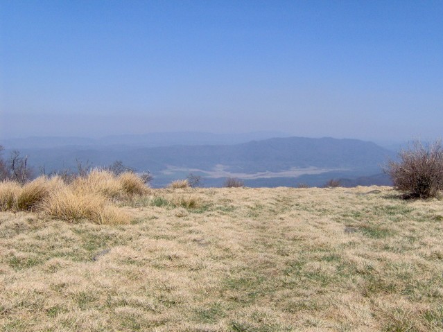
Gregory Bald is a mountain in the Great Smoky Mountains. It has an elevation of 4,949 feet (1,508 meters) above sea level. The mountain's majestic summit makes it a popular hiking destination. Another feature that attracts many visitors are the flame azaleas that bloom over the bald every summer. The azaleas reach peak bloom around mid-to-late June. Gregory Bald is located along the Tennessee-North Carolina border, between Blount County and Swain County. It rises appx. 3,000 feet above its northern base in Cades Cove, and appx. 3,300 feet above its southern base at Fontana Lake. The mountain is located entirely within the Great Smoky Mountains National Park. Gregory Bald is a type of mountain known as a grassy bald. Unlike most summits in the Appalachians, which are heavily forested or culminate in jagged peaks, grassy balds are covered by a thick layer of wild grass. Trees and other foliage are sparse. How and why a summit develops into a grassy bald is unknown. While t ... [...More Info...] [...Related Items...] OR: [Wikipedia] [Google] [Baidu] |
Lake In The Sky (Tennessee)
Lake in the Sky is an artificial lake in Blount County, Tennessee, formed by damming Flat Creek. It lies in the center of Top of the World, an unincorporated community. Location Lake in the Sky is a small mountain lake located on the slopes of Chilhowee Mountain. Foothills Parkway passes just to the northwest, and the boundary of the Great Smoky Mountains National Park lies just to the southeast. The lake lies in an area called The Flats, on a spur of Chilhowee Mountain. The surrounding country is rugged. Lake in the Sky is at an elevation of above sea level. The nearest major town is Townsend, Tennessee. Lake The lake is part of the watershed of the Little River. It is near the head of Flat Creek, a tributary of Hesse Creek. The Flat Creek dam is at the north end of the lake. The dam was built in 1966, forming the lake. Flat Creek is non-navigable. Lake of the Sky is not operated for flood control purposes, but it is one of several dams in Blount County that may provide some p ... [...More Info...] [...Related Items...] OR: [Wikipedia] [Google] [Baidu] |


