|
HMNZS Resolution
HMNZS ''Resolution'' (A14) was a hydrographic ship of the Royal New Zealand Navy (RNZN). Originally the United States Naval Ship USNS ''Tenacious'' (T-AGOS-17), the Stalwart class tactical auxiliary general ocean surveillance ships, ''Stalwart''-class ocean surveillance ship was used by the United States to locate and track Soviet submarines from 1989 to 1997, when she was transferred to the RNZN for use as a hydrographic survey ship. She served until 27 April 2012. She was subsequently sold to EGS Group, a private surveying company, and renamed RV ''Geo Resolution''. Construction The ship's construction contract was awarded 20 February 1987 to VT Halter Marine, Inc. of Moss Point, Mississippi, under then name ''Intrepid''. Her keel was laid down 26 February 1988, she was launched 17 February 1989 and commissioned as USNS ''Tenacious'' on 29 September 1989. The renaming was prompted by protests from veterans of the ''Essex''-class aircraft carrier , who felt that the surveillanc ... [...More Info...] [...Related Items...] OR: [Wikipedia] [Google] [Baidu] |
Ocean Surveillance Ship
A spy ship or reconnaissance vessel is a dedicated ship intended to gather intelligence, usually by means of sophisticated electronic eavesdropping. In a wider sense, any ship intended to gather information could be considered a spy ship. Spy ships are usually controlled by a nation's government, due to the high costs and advanced equipment required. They tend to be parts of the nation's navy, though they may also be operated by secret services. Naval trawlers masquerade as civilian ships such as fishing trawlers, which could be reasonably expected to remain in a certain area for a long time. Ships which are used to infiltrate spies or special forces are sometimes also called "spy ships". History An early version of what would become known as a spy ship is the United States civilian cargo ship , which made frequent voyages to Japan, China and the Philippines with cargo and passengers during the 1920s and 1930s. Starting in 1933 as a station ship she was assigned to monitor ... [...More Info...] [...Related Items...] OR: [Wikipedia] [Google] [Baidu] |
Survey Ships Of The Royal New Zealand Navy
Commissioned survey and research vessels of the Royal New Zealand Navy from its formation on 1 October 1941 to the present: See also * Current Royal New Zealand Navy ships * List of ships of the Royal New Zealand Navy * History of research ships The research ship had origins in the early voyages of exploration. By the time of James Cook's HM Bark Endeavour, ''Endeavour'', the essentials of what today we would call a research ship are clearly apparent. In 1766, the Royal Society hired Cook ... References * Walters, Sydney David (1956) ''The Royal New Zealand Navy: Official History of World War II'', Department of Internal Affairs, WellingtoOnline* McDougall, R J (1989) ''New Zealand Naval Vessels.'' Page 115–123.Government Printing Office. Official web site External links Hydrography in New ZealandHydrographic surveying Military history of New Zealand Royal New Zealand Navy {{Navy-stub ... [...More Info...] [...Related Items...] OR: [Wikipedia] [Google] [Baidu] |
Lyttelton, New Zealand
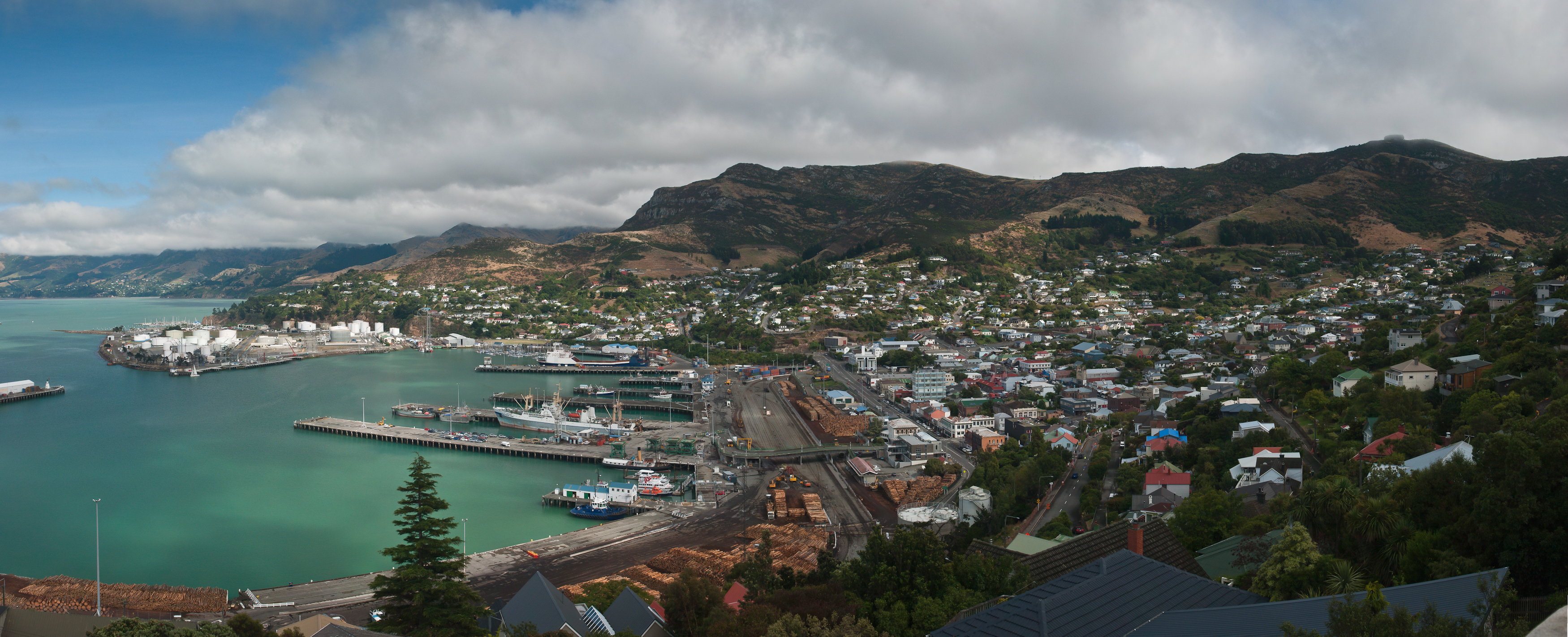
Lyttelton ( or ''Riritana'') is a port town on the north shore of Lyttelton Harbour / Whakaraupō, at the northwestern end of Banks Peninsula and close to Christchurch, on the eastern coast of the South Island of New Zealand. As a landing point for Christchurch-bound seafarers, Lyttelton has historically been regarded as the "Gateway to Canterbury" for colonial settlers. The port is a regular destination for cruise ships. It is the South Island's principal goods-transport terminal, handling 34% of exports and 61% of imports by value. In 2009 Lyttelton was awarded Category I Historic Area status by the Historic Places Trust (NZHPT) defined as "an area of special or outstanding historical or cultural heritage significance or value", not long before much of the historic fabric was destroyed in the 2011 Christchurch earthquake. Location Lyttelton is the largest settlement on Lyttelton Harbour / Whakaraupō, an inlet on the northwestern side of Banks Peninsula extending 18 km ... [...More Info...] [...Related Items...] OR: [Wikipedia] [Google] [Baidu] |
2011 Canterbury Earthquake
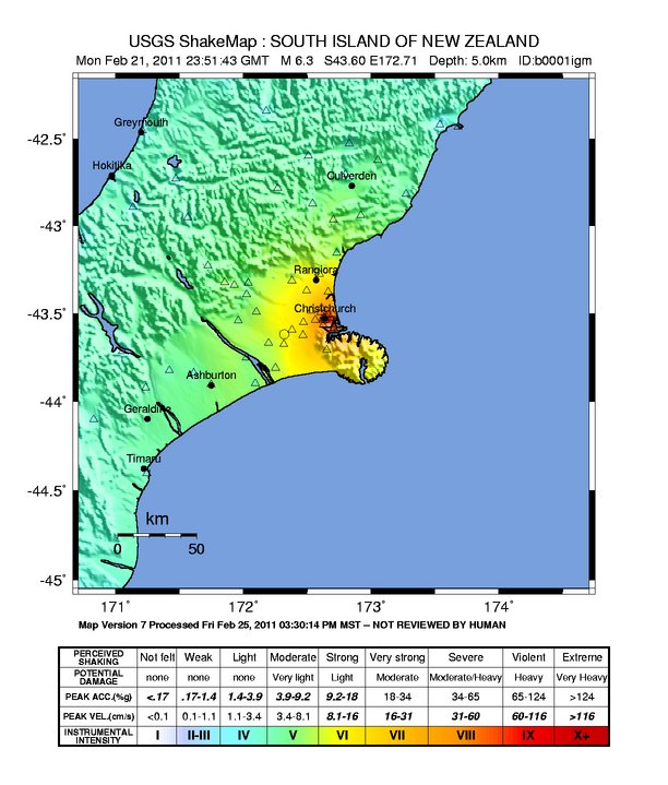
A major earthquake occurred in Christchurch on Tuesday 22 February 2011 at 12:51 p.m. local time (23:51 UTC, 21 February). The () earthquake struck the Canterbury Region in the South Island, centred south-east of the central business district. It caused widespread damage across Christchurch, killing 185 people in New Zealand's fifth-deadliest disaster. Scientists classified it as an intraplate earthquake and a potential aftershock of the September 2010 Canterbury earthquake. Christchurch's central city and eastern suburbs were badly affected, with damage to buildings and infrastructure already weakened by the 2010 Canterbury earthquake and its aftershocks. Significant liquefaction affected the eastern suburbs, producing around 400,000 tonnes of silt. The earthquake was felt across the South Island and parts of the lower and central North Island. While the initial quake only lasted for approximately 10 seconds, the damage was severe because of the location ... [...More Info...] [...Related Items...] OR: [Wikipedia] [Google] [Baidu] |
Spirit Of New Zealand
The tall ship ''Spirit of New Zealand'' is a steel-hulled, three-masted barquentine from Auckland, New Zealand. It was purpose-built by the Spirit of Adventure Trust in 1986 for youth development. It is 42.5 m in total length and carries a maximum of 40 trainees and 14 crew on overnight voyages. The ship's home port is Auckland, and it spends most of its time sailing around the Hauraki Gulf. During the summer season, it often sails to the Marlborough Sounds and Nelson, at the top of the South Island. The spirit of the project was derived from the sail training operations of the schooners "Sir Winston Churchill" and "Malcolm Miller" which were built for the organisation formerly known as the Sail Training Association (STA) The ship is used for a year-round programme of youth development, consisting primarily of 10-day individual voyages for 16- to 18-year-olds and 5-day ''Spirit Trophy'' voyages for teams of 10 Year 10 students. Once a year, an ''Inspiration'' voyage for ... [...More Info...] [...Related Items...] OR: [Wikipedia] [Google] [Baidu] |
Survey Motor Boat
A survey motor boat (abbreviated SMB), is a vessel equipped for commercial and/or military hydrographic survey Hydrographic survey is the science of measurement and description of features which affect maritime navigation, marine construction, dredging, offshore wind farms, offshore oil exploration and drilling and related activities. Surveys may als ... operations. ReferencesAustralian Hydrographic Service - frequently asked questions Motorboats {{ship-type-stub ... [...More Info...] [...Related Items...] OR: [Wikipedia] [Google] [Baidu] |
Land Information New Zealand
Land Information New Zealand (LINZ; ) is the public service department of New Zealand charged with geographical information and surveying functions as well as handling land titles, and managing Crown land and property. The minister responsible is the Minister for Land Information, and was formerly the Minister of Survey and Land Information. LINZ was established in 1996 following the restructure of the Department of Survey and Land Information (DOSLI), which was itself one of the successor organisations to the Department of Lands and Survey. The New Zealand Geographic Board secretariat is part of LINZ and provides the Board with administrative and research assistance and advice. The Minister for Land Information is Chris Penk. Gaye Searancke was appointed Chief Executive of Land Information New Zealand in August 2019. She succeeded Andrew Crisp, who had been in the post since 2016. Nature and scope of functions LINZ's purpose is to: *Maintain and build confidence in prop ... [...More Info...] [...Related Items...] OR: [Wikipedia] [Google] [Baidu] |
Hydrographic Survey
Hydrographic survey is the science of measurement and description of features which affect maritime navigation, marine construction, dredging, offshore wind farms, offshore oil exploration and drilling and related activities. Surveys may also be conducted to determine the route of subsea cables such as telecommunications cables, cables associated with wind farms, and HVDC power cables. Strong emphasis is placed on soundings, shorelines, tides, currents, seabed and submerged obstructions that relate to the previously mentioned activities. The term ''hydrography'' is used synonymously to describe ''maritime cartography'', which in the final stages of the hydrographic process uses the raw data collected through hydrographic survey into information usable by the end user. Hydrography is collected under rules which vary depending on the acceptance authority. Traditionally conducted by ships with a sounding line or echo sounding, surveys are increasingly conducted with the aid o ... [...More Info...] [...Related Items...] OR: [Wikipedia] [Google] [Baidu] |
Third Voyage Of James Cook
James Cook's third and final voyage (12 July 1776 – 4 October 1780) was a British attempt to discover the Northwest Passage between the Atlantic ocean and the Pacific coast of North America. The attempt failed and Death of James Cook, Cook was killed at Hawaii in a violent dispute with the local inhabitants. The ostensible purpose of the voyage was to return Omai, a young man from Raiatea, to his homeland, but the British Admiralty used this as a cover for their plan to send Cook on a voyage to find the Northwest Passage, should it exist. HMS Resolution (1771), HMS ''Resolution'', to be commanded by Cook, and HMS Discovery (1774), HMS ''Discovery'', commanded by Charles Clerke, were prepared for the voyage which started from Plymouth in 1776. After Omai was returned to his homeland, the ships sailed into the central Pacific where they encountered the hitherto unknown (to Europeans) Hawaiian Archipelago, before reaching the Pacific coast of North America. After exploring a ... [...More Info...] [...Related Items...] OR: [Wikipedia] [Google] [Baidu] |
Second Voyage Of James Cook
The second voyage of James Cook, from 1772 to 1775, commissioned by the British government with advice from the Royal Society, was designed to circumnavigate the globe as far south as possible to finally determine whether there was any great southern landmass, or '' Terra Australis''. On his first voyage, Cook had demonstrated by circumnavigating New Zealand that it was not attached to a larger landmass to the south, and he charted almost the entire eastern coastline of mainland Australia, yet ''Terra Australis'' was believed to lie further south. Alexander Dalrymple and others of the Royal Society still believed that this massive southern continent should exist. After a delay brought about by the botanist Joseph Banks' unreasonable demands, the ships '' Resolution'' and ''Adventure'' were fitted for the voyage and set sail for the Antarctic in July 1772. On 17 January 1773, ''Resolution'' was the first ship to venture south of the Antarctic Circle, which she did twice more ... [...More Info...] [...Related Items...] OR: [Wikipedia] [Google] [Baidu] |
James Cook
Captain (Royal Navy), Captain James Cook (7 November 1728 – 14 February 1779) was a British Royal Navy officer, explorer, and cartographer famous for his three voyages of exploration to the Pacific and Southern Oceans, conducted between 1768 and 1779. He completed the first recorded circumnavigation of the main islands of New Zealand and was the first known European to visit the eastern coastline of Australia and the Hawaiian Islands. Cook joined the British merchant navy as a teenager before enlisting in the Royal Navy in 1755. He served during the Seven Years' War, and subsequently surveyed and mapped much of the entrance to the St. Lawrence River during the Battle of the Plains of Abraham, siege of Quebec. In the 1760s, he mapped the coastline of Newfoundland (island), Newfoundland and made important astronomical observations which brought him to the attention of the Admiralty (United Kingdom), Admiralty and the Royal Society. This acclaim came at a crucial moment in Brit ... [...More Info...] [...Related Items...] OR: [Wikipedia] [Google] [Baidu] |


