|
Güglingen
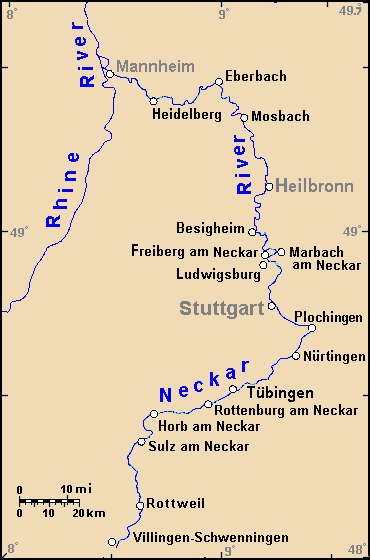
Güglingen () is a town in the district of Heilbronn in Baden-Württemberg in southern Germany. It is situated 18 km southwest of Heilbronn. Geography Güglingen is situated in a valley called Zabergäu in the southwest district of Heilbronn. Neighbouring municipalities Neighbouring towns and municipalities (clockwise): Pfaffenhofen, Eppingen, Brackenheim, Cleebronn (all of the district of Heilbronn) and Sachsenheim (Ludwigsburg (district)). Town structure The town Güglingen consists of Güglingen itself (4254 inhabitants), with its subdivisions Eibensbach (1035) and Frauenzimmern (922). Total: 6211 (June 30, 2005). History In the Stone Age the communal land of Güglingen was settled in the time of the Romans and Celts. In 2002, two Mithras sanctuaries have been discovered and dug up. By the previous finds it is guessed that the Roman settlement had a surface of 10 hectare. The village Güglingen was probably founded in the 4th or 5th century and was mentioned document ... [...More Info...] [...Related Items...] OR: [Wikipedia] [Google] [Baidu] |
Layher
Layher Holding GmbH & Co. KG is a globally leading German manufacturer of scaffolding, protective and event systems and ladders. The company operates two production facilities in Germany. The headquarters in Güglingen-Eibensbach produces steel scaffolding components, while the second plant in neighbouring Güglingen makes aluminium and wooden components. History The timber merchant Wilhelm Layher established the company in 1945 to make agricultural implements and ladders out of wood. As the German economy recovered, he identified the need for construction scaffolding, and by 1948 was already specializing in the production of ladder scaffolding. His daughter, Ruth Langer, and his two sons, Eberhard and Ulrich Layher, also worked in the company and successfully continued the business after the death of the founder in 1962. Under their management, Layher evolved into the biggest manufacturer of system scaffolding: with Layher SpeedyScaf, SpeedyScaf in 1965 and Layher Allround Scaff ... [...More Info...] [...Related Items...] OR: [Wikipedia] [Google] [Baidu] |
Cleebronn
Cleebronn () is a municipality in the district of Heilbronn in Baden-Württemberg in southern Germany. Geography Cleebronn is in the Zabergäu in the south of the district of Heilbronn, directly in the north of the Stromberg mountain with an elevation of . The landscape is characterised by wine-growing. The symbol of the municipality and the whole Zabergäu is the Michaelsberg, which has an elevation of . Neighbouring municipalities Neighbouring towns of Cleebronn are (clockwise from the west): Güglingen, Brackenheim (both in the district of Heilbronn), Bönnigheim and Sachsenheim (both in the district of Ludwigsburg). Cleebronn has combined with Brackenheim to form a joint association. Municipal structure Cleebronn includes the villages of Treffentrill and Katharinenplaisir. History The first documented mention of Cleebronn was in 1279 as ''Kleberen''. In the 13th century there were some possessions of the Principality of Mainz around the Michaelsberg being rented to ... [...More Info...] [...Related Items...] OR: [Wikipedia] [Google] [Baidu] |
Brackenheim
Brackenheim () is a town in the ''Landkreis'' Heilbronn in Baden-Württemberg in southern Germany. It is southwest of Heilbronn. With of vineyards, it is the biggest grape-growing municipality of Württemberg. Geography Geographical position Brackenheim is situated on the river Zaber in the Zabergäu in southwestern district of Heilbronn, in the north of Baden-Württemberg, Germany. The landscape is characterized by extensive vineyards. Neighbouring municipalities Neighbouring towns and municipalities (clockwise): ''Cleebronn'', ''Güglingen'', ''Eppingen'', ''Schwaigern'', '' Nordheim'', ''Lauffen (Neckar)'' (all district of Heilbronn), ''Kirchheim (Neckar)'' and ''Bönnigheim'' (both Ludwigsburg (district)). Town structure Apart from Brackenheim itself, it consists of the following: *Botenheim *Dürrenzimmern *Hausen an der Zaber *Haberschlacht *Meimsheim *Neipperg *Stockheim. History The communal land of Brackenheim has been settled for 5,000-6,000 years. Botenheim a ... [...More Info...] [...Related Items...] OR: [Wikipedia] [Google] [Baidu] |
Dorking
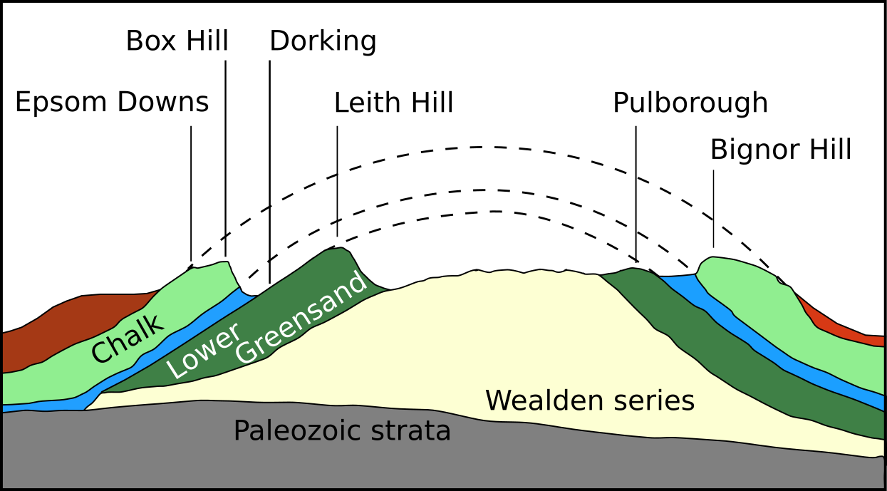
Dorking () is a market town in Surrey in South East England, about south of London. It is in Mole Valley District and the council headquarters are to the east of the centre. The High Street runs roughly east–west, parallel to the Pipp Brook and along the northern face of an outcrop of Lower Greensand. The town is surrounded on three sides by the Surrey Hills Area of Outstanding Natural Beauty and is close to Box Hill and Leith Hill. The earliest archaeological evidence of human activity is from the Mesolithic and Neolithic periods, and there are several Bronze Age bowl barrows in the local area. The town may have been the site of a staging post on Stane Street during Roman times, however the name 'Dorking' suggests an Anglo-Saxon origin for the modern settlement. A market is thought to have been held at least weekly since early medieval times and was highly regarded for the poultry traded there. The Dorking breed of domestic chicken is named after the town. The loca ... [...More Info...] [...Related Items...] OR: [Wikipedia] [Google] [Baidu] |
Zaberfeld
Zaberfeld () is a town in the district of Heilbronn in Baden-Württemberg in Germany. Geography Zaberfeld lies in the Zabergäu, in the southwestern corner of the Heilbronn district, at the head of the Zaber river. Neighboring communities Zaberfeld's neighbouring towns and communities are (clockwise, beginning in the north): Eppingen, Pfaffenhofen (both in the Heilbronn district), Sachsenheim (Ludwigsburg district), Sternenfels (Enzkreis), Kürnbach and Sulzfeld (both in the Karlsruhe district). Base communities The district of Zaberfeld is formed from Zaberfeld, Leonbronn, Michelbach and Ochsenburg. History Zaberfeld was probably founded in 1000 AD. In 1321, it was ruled by the Herren von Magenheim of Baden. In 1355, Zaberfeld came under the rule of Württemberg and in 1749 became part of Württemberg. From 1390 to 1749 it was ruled by the Herren von Sternenfels as part of Württemberg under a feudal governing system. From 1807 to 1810 it was part of the Oberamt Gügli ... [...More Info...] [...Related Items...] OR: [Wikipedia] [Google] [Baidu] |
Heilbronn (district)
Landkreis Heilbronn () is a ''Landkreis'' (district) in the north of Baden-Württemberg, Germany. Neighboring districts are (from north clockwise) Neckar-Odenwald, Hohenlohe, Schwäbisch Hall, Rems-Murr, Ludwigsburg, Enz, Karlsruhe and Rhein-Neckar. In the centre of it is the free-city of Heilbronn, which is its own separate administrative area. History The predecessor to the district is the ''Oberamt Heilbronn'', which was created in 1803 when the previously Free Imperial City of Heilbronn was incorporated into the Electorate of Württemberg. In 1926, about half of the Oberamt (old district) of Weinsberg was added. In 1938, it was recognized as a district, and in addition to the previous Oberamt, parts of the dissolved Oberämter Neckarsulm, Brackenheim, Marbach and Besigheim were added. The city of Heilbronn was not included into the district. In 1973, the ''Landkreise'' (districts) were reorganized, and part of the dissolved districts of Sinsheim, Mosbach, Buchen and Schwäbisch ... [...More Info...] [...Related Items...] OR: [Wikipedia] [Google] [Baidu] |
Heilbronn
Heilbronn () is a List of cities and towns in Germany, city in northern Baden-Württemberg, Germany, surrounded by Heilbronn (district), Heilbronn District. With over 126,000 residents, it is the sixth-largest city in the state. From the late Middle Ages, it developed into an important trading centre. At the beginning of the 19th century, Heilbronn became one of the centres of early industrialisation in Württemberg. Heilbronn's old town was completely destroyed during the air raid of 4 December 1944 and rebuilt in the 1950s. Today Heilbronn is the economic centre of the Heilbronn-Franconia, Heilbronn-Franken region. Heilbronn is known for its wine industry and is nicknamed ''Käthchenstadt'', after Heinrich von Kleist's ''Das Käthchen von Heilbronn''. Geography Heilbronn is located in the northern corner of the Neckar Sedimentary basin, basin at the bottom of the Wartberg (Heilbronn), Wartberg (308 m). It occupies both banks of the Neckar, and the highest spot inside city limit ... [...More Info...] [...Related Items...] OR: [Wikipedia] [Google] [Baidu] |
Eppingen
Eppingen () is a town in the district of Heilbronn in Baden-Württemberg in southern Germany. The town has the second-largest population in the district. Eppingen lies in the Kraichgau, a hilly region in southwestern Germany, close to the confluence of the Elsenz and Hilsbach Rivers. History Eppingen was first mentioned in 985 when Otto III gave the settlement to the diocese of Worms. The ending "-ingen" was common for towns colonised by the Alamanni clan in the 3rd and 4th centuries. Eppingen was owned by Salier in the 11th century, and by the Staufer in the 12th century. In 1188, it became a fortified village and, in 1192, a town, elevated by Heinrich VI. The town was distrained several times in the 14th century, but never lost the status of a town. After the win of the Electorate of the Palatinate over margraviate Baden in 1435, it finally became a part of the Electorate of the Palatinate but was once more distrained to the knights of Gemmingen, from 1469 to approximatel ... [...More Info...] [...Related Items...] OR: [Wikipedia] [Google] [Baidu] |
Hohenstaufen
The Hohenstaufen dynasty (, , ), also known as the Staufer, was a noble family of unclear origin that rose to rule the Duchy of Swabia from 1079, and to royal rule in the Holy Roman Empire during the Middle Ages from 1138 until 1254. The dynasty's most prominent rulers – Frederick I (1155), Henry VI (1191) and Frederick II (1220) – ascended the imperial throne and also reigned over Italy and Burgundy. The non-contemporary name of 'Hohenstaufen' is derived from the family's Hohenstaufen Castle on the Hohenstaufen mountain at the northern fringes of the Swabian Jura, near the town of Göppingen. Under Hohenstaufen rule, the Holy Roman Empire reached its greatest territorial extent from 1155 to 1268. Name The name Hohenstaufen was first used in the 14th century to distinguish the 'high' (''hohen'') conical hill named Staufen in the Swabian Jura (in the district of Göppingen) from the village of the same name in the valley below. The new name was only applied to the hill ... [...More Info...] [...Related Items...] OR: [Wikipedia] [Google] [Baidu] |
Timber Framing
Timber framing (german: Holzfachwerk) and "post-and-beam" construction are traditional methods of building with heavy timbers, creating structures using squared-off and carefully fitted and joined timbers with joints secured by large wooden pegs. If the structural frame of load-bearing timber is left exposed on the exterior of the building it may be referred to as half-timbered, and in many cases the infill between timbers will be used for decorative effect. The country most known for this kind of architecture is Germany, where timber-framed houses are spread all over the country. The method comes from working directly from logs and trees rather than pre-cut dimensional lumber. Hewing this with broadaxes, adzes, and draw knives and using hand-powered braces and augers (brace and bit) and other woodworking tools, artisans or framers could gradually assemble a building. Since this building method has been used for thousands of years in many parts of the world, many styles ... [...More Info...] [...Related Items...] OR: [Wikipedia] [Google] [Baidu] |
France
France (), officially the French Republic ( ), is a country primarily located in Western Europe. It also comprises of Overseas France, overseas regions and territories in the Americas and the Atlantic Ocean, Atlantic, Pacific Ocean, Pacific and Indian Oceans. Its Metropolitan France, metropolitan area extends from the Rhine to the Atlantic Ocean and from the Mediterranean Sea to the English Channel and the North Sea; overseas territories include French Guiana in South America, Saint Pierre and Miquelon in the North Atlantic, the French West Indies, and many islands in Oceania and the Indian Ocean. Due to its several coastal territories, France has the largest exclusive economic zone in the world. France borders Belgium, Luxembourg, Germany, Switzerland, Monaco, Italy, Andorra, and Spain in continental Europe, as well as the Kingdom of the Netherlands, Netherlands, Suriname, and Brazil in the Americas via its overseas territories in French Guiana and Saint Martin (island), ... [...More Info...] [...Related Items...] OR: [Wikipedia] [Google] [Baidu] |
Auneau
Auneau () is a former commune in the Eure-et-Loir department in northern France. On 1 January 2016, it was merged into the new commune of Auneau-Bleury-Saint-Symphorien. 20 November 2015 Population See also *Communes of the Eure-et-Loir department
The following is a list of the 365 communes of the Eure-et-Loir department of France.
The communes cooperate in the following intercommunalities (as of 2020):
[...More Info...] [...Related Items...] OR: [Wikipedia] [Google] [Baidu] |

