|
Great East Road
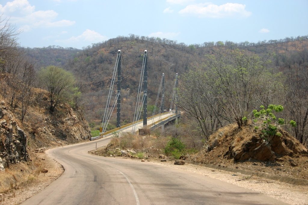
The Great East Road is a major road in Zambia and the main route linking its Eastern Province with the rest of the country. It is also the major link between Zambia and Malawi and between Zambia and northern Mozambique.Terracarta: ''Zambia, 2nd edition'', International Travel Maps, Vancouver, Canada, 2000. However, the route does not carry as much traffic as many of the other regional arterial roads and between the main cities it serves, Lusaka and Chipata, it passes through rural and wilderness areas. In Lusaka the road forms the main arterial road for the eastern suburbs. The entire route from Lusaka to Chipata and the Malawi Border Post is designated the T4 Road on Zambia's road network. History Chipata, the capital of the Eastern Province was an early outpost of the British colonial administration as Fort Jameson when Zambia was Northern Rhodesia. Like most of the Eastern Province, it had much easier access to Malawi, then the British protectorate of Nyasaland, and to the Moz ... [...More Info...] [...Related Items...] OR: [Wikipedia] [Google] [Baidu] |
Great North Road, Zambia
The Great North Road is a major route in Zambia, running north from Lusaka through Kabwe, Kapiri Mposhi (the road continues by way of a right turn just north of Kapiri Mposhi), Serenje, Mpika (where it makes a left turn), Kasama, Mbala and Mpulungu. 82km North of Mpika is a signposted right turn onto a well maintained gravel road leading to Shiwa Ng'andu (12km) and Kapishya Hot Springs (32km). The road from Zambia's border with Zimbabwe at Chirundu to Lusaka is now regarded as being part of the Great North Road; but this is only since the opening of the Chirundu Bridge in 1939 - before that, the Great North Road ran from Livingstone to Lusaka, as part of the original Cape to Cairo Red Line by Cecil John Rhodes. The portion from Mbala to Mpulungu could be regarded as a spur linking to the Lake Tanganyika steamer service which was popular with travellers up to the 1950s. When the Mpika-Tanzania highway (the Tanzam Highway) via Tunduma was upgraded in the 1960s and provided a ... [...More Info...] [...Related Items...] OR: [Wikipedia] [Google] [Baidu] |
Zambia
Zambia (), officially the Republic of Zambia, is a landlocked country at the crossroads of Central Africa, Central, Southern Africa, Southern and East Africa, although it is typically referred to as being in Southern Africa at its most central point. Its neighbours are the Democratic Republic of the Congo to the north, Tanzania to the northeast, Malawi to the east, Mozambique to the southeast, Zimbabwe and Botswana to the south, Namibia to the southwest, and Angola to the west. The capital city of Zambia is Lusaka, located in the south-central part of Zambia. The nation's population of around 19.5 million is concentrated mainly around Lusaka in the south and the Copperbelt Province to the north, the core economic hubs of the country. Originally inhabited by Khoisan peoples, the region was affected by the Bantu expansion of the thirteenth century. Following the arrival of European exploration of Africa, European explorers in the eighteenth century, the British colonised the r ... [...More Info...] [...Related Items...] OR: [Wikipedia] [Google] [Baidu] |
Blantyre, Malawi
Blantyre () is Malawi's centre of finance and commerce, and its second largest city, with an enumerated 800,264 inhabitants . It is sometimes referred to as the commercial and industrial capital of Malawi as opposed to the political capital, Lilongwe. It is the capital of the country's Southern Region, Malawi, Southern Region as well as the Blantyre District. History Blantyre was founded in 1876 through the missionary work of the Church of Scotland. It was named after Blantyre, South Lanarkshire, Scotland, birthplace of the explorer David Livingstone. The site was chosen by Henry Henderson, who was joined there on 23 October 1876 by Dr T. T. Macklin and others. Dr Macklin took over the leadership of the mission and began the work of building; but it was not until 1878 that the first ordained minister, Rev. Duff MacDonald, joined the mission. The original missionaries, for various reasons, faced local opposition and three of them were recalled. From 1881–1898 the mission w ... [...More Info...] [...Related Items...] OR: [Wikipedia] [Google] [Baidu] |
Bulawayo
Bulawayo (, ; Ndebele: ''Bulawayo'') is the second largest city in Zimbabwe, and the largest city in the country's Matabeleland region. The city's population is disputed; the 2022 census listed it at 665,940, while the Bulawayo City Council claimed it to be about 1.2 million. Bulawayo covers an area of about in the western part of the country, along the Matsheumhlope River. Along with the capital Harare, Bulawayo is one of two cities in Zimbabwe that is also a province. Bulawayo was founded by a group led by Gundwane Ndiweni around 1840 as the kraal of Mzilikazi, the Ndebele king and was known as Gibixhegu. His son, Lobengula, succeeded him in the 1860s, and changed the name to kobulawayo and ruled from Bulawayo until 1893, when the settlement was captured by British South Africa Company soldiers during the First Matabele War. That year, the first white settlers arrived and rebuilt the town. The town was besieged by Ndebele warriors during the Second Matabele War. Bulawayo ... [...More Info...] [...Related Items...] OR: [Wikipedia] [Google] [Baidu] |
Fort Jameson
The city of Chipata is the administrative centre of the Eastern Province of Zambia and Chipata District. It was declared the 5th city of the country, after Lusaka, Ndola, Kitwe and Livingstone, by President Edgar Lungu on 24 February 2017. The city has undergone rapid economic and infrastructure growth in the years, leading up to city status. Location Chipata is located approximately , east of Lusaka, the capital city of Zambia. This is about west of Lilongwe, the capital city of Malawi. The geographical coordinates of Chipata are 13°38'43.0"S, 32°38'47.0"E (Latitude:13°38'43.0"S; Longitude:32°38'47.0"E). The average elevation of Chipata is , above sea level. Overview Having a modern market, a central hospital, shopping malls, a university, some colleges and a number of schools, Chipata is the business and administrative hub of the region. The town boasts a four star hotel, a golf course, an airport, and a "welcome arch". Developed areas includes Kalongwezi, Moth, and Litt ... [...More Info...] [...Related Items...] OR: [Wikipedia] [Google] [Baidu] |
Livingstone, Zambia
Livingstone is a city in Zambia. Until 1935, it served as the capital city of Zambia (then Northern Rhodesia). Lying 10 km (6.2 mi) to the north of the Zambezi River, it is a tourism attraction center for the Victoria Falls, Zambia, Victoria Falls and a border town with road and rail connections to Zimbabwe on the other side of the Victoria Falls. A historic British Empire, British colonial city, its present population was enumerated at 134,349 inhabitants at the 2010 census. It is named after David Livingstone, the Scotland, Scottish explorer and missionary who was the first European to Exploration, explore the area. Pre-colonial History Mukuni, to the south-east of present-day Livingstone, was the largest village in the area before Livingstone was founded. Its Leya language, Baleya inhabitants, originally from the Rozwi culture in Zimbabwe, were conquered by Chief Mukunda, Mukuni who came from the DR Congo, Congo in the 16th century. Another group of Baleya under Chief ... [...More Info...] [...Related Items...] OR: [Wikipedia] [Google] [Baidu] |
Beira, Mozambique
Beira is the capital and largest city of Sofala Province, where the Pungwe River meets the Indian Ocean, in the central region of Mozambique. It is the fourth-largest city by population in Mozambique, after Maputo, Matola and Nampula. Beira had a population of 397,368 in 1997, which grew to 530,604 in 2019. A coastal city, it holds the regionally significant Port of Beira, which acts as a gateway for both the central interior portion of the country as well as the land-locked nations of Zimbabwe, Zambia and Malawi. Originally called Chiveve after a local river, it was renamed Beira to honour the Portuguese Crown prince Dom Luís Filipe (titled Prince of Beira, itself referring to the traditional Portuguese province of Beira), who had visited Mozambique in the early 1900s. It was first developed by the Portuguese Mozambique Company in the 19th century, supplanting Sofala as the country's main port. It was then directly developed by the Portuguese colonial government from 1947 until ... [...More Info...] [...Related Items...] OR: [Wikipedia] [Google] [Baidu] |
Quelimane
Quelimane () is a seaport in Mozambique. It is the administrative capital of the Zambezia Province and the province's largest city, and stands from the mouth of the Rio dos Bons Sinais (or "River of the Good Signs"). The river was named when Vasco da Gama, on his way to India, reached it and saw "good signs" that he was on the right path. The town was the end point of David Livingstone's west-to-east crossing of south-central Africa in 1856. Portuguese is the official language of Mozambique, and many residents of the areas surrounding Quelimane speak Portuguese. The most common local language is Chuabo. Quelimane, along with much of Zambezia Province, is extremely prone to floods during Mozambique's rainy season. The most recent bout of severe flooding took place in January 2007. History Pre-colonial era The town originated as a Swahili trade centre, and then grew as a slave market. Quelimane was founded by Muslim traders (see Kilwa Sultanate) and was one of the oldest town ... [...More Info...] [...Related Items...] OR: [Wikipedia] [Google] [Baidu] |
Nyasaland
Nyasaland () was a British protectorate located in Africa that was established in 1907 when the former British Central Africa Protectorate changed its name. Between 1953 and 1963, Nyasaland was part of the Federation of Rhodesia and Nyasaland. After the Federation was dissolved, Nyasaland became independent from Britain on 6 July 1964 and was renamed Malawi. Nyasaland's history was marked by the massive loss of African communal lands in the early colonial period. In January 1915, the Reverend John Chilembwe staged an attempt at rebellion in protest at discrimination against Africans. Colonial authorities reassessed some of their policies. From the 1930s, a growing class of educated African elite, many educated in the United Kingdom, became increasingly politically active and vocal about gaining independence. They established associations and, after 1944, the Nyasaland African Congress (NAC). When Nyasaland was forced in 1953 into a Federation with Southern and Northern Rho ... [...More Info...] [...Related Items...] OR: [Wikipedia] [Google] [Baidu] |
Protectorate
A protectorate, in the context of international relations, is a State (polity), state that is under protection by another state for defence against aggression and other violations of law. It is a dependent territory that enjoys autonomy over most of its internal affairs, while still recognizing the suzerainty of a more powerful sovereign state without being a possession. In exchange, the protectorate usually accepts specified obligations depending on the terms of their arrangement. Usually protectorates are established de jure by a treaty. Under certain conditions—as with History of Egypt under the British#Veiled Protectorate (1882–1913), Egypt under British rule (1882–1914)—a state can also be labelled as a de facto protectorate or a veiled protectorate. A protectorate is different from a colony as it has local rulers, is not directly possessed, and rarely experiences colonization by the suzerain state. A state that is under the protection of another state while retain ... [...More Info...] [...Related Items...] OR: [Wikipedia] [Google] [Baidu] |
Northern Rhodesia
Northern Rhodesia was a British protectorate in southern Africa, south central Africa, now the independent country of Zambia. It was formed in 1911 by Amalgamation (politics), amalgamating the two earlier protectorates of Barotziland-North-Western Rhodesia and North-Eastern Rhodesia.''Commonwealth and Colonial Law'' by Kenneth Roberts-Wray, London, Stevens, 1966. P. 753 It was initially administered, as were the two earlier protectorates, by the British South Africa Company (BSAC), a chartered company, on behalf of the British Government. From 1924, it was administered by the British Government as a protectorate, under similar conditions to other British-administered protectorates, and the special provisions required when it was administered by BSAC were terminated.Northern Rhodesia Order in Council, 1924, S.R.O. 1924 No. 324, S.RO. & S.I. Rev VIII, 154 Although under the BSAC charter it had features of a charter colony, the BSAC's treaties with local rulers, and British legisla ... [...More Info...] [...Related Items...] OR: [Wikipedia] [Google] [Baidu] |
Colonialism
Colonialism is a practice or policy of control by one people or power over other people or areas, often by establishing colonies and generally with the aim of economic dominance. In the process of colonisation, colonisers may impose their religion, language, economics, and other cultural practices. The foreign administrators rule the territory in pursuit of their interests, seeking to benefit from the colonised region's people and resources. It is associated with but distinct from imperialism. Though colonialism has existed since ancient times, the concept is most strongly associated with the European colonial period starting with the 15th century when some European states established colonising empires. At first, European colonising countries followed policies of mercantilism, aiming to strengthen the home-country economy, so agreements usually restricted the colony to trading only with the metropole (mother country). By the mid-19th century, the British Empire gave up me ... [...More Info...] [...Related Items...] OR: [Wikipedia] [Google] [Baidu] |


