|
Gouina Falls
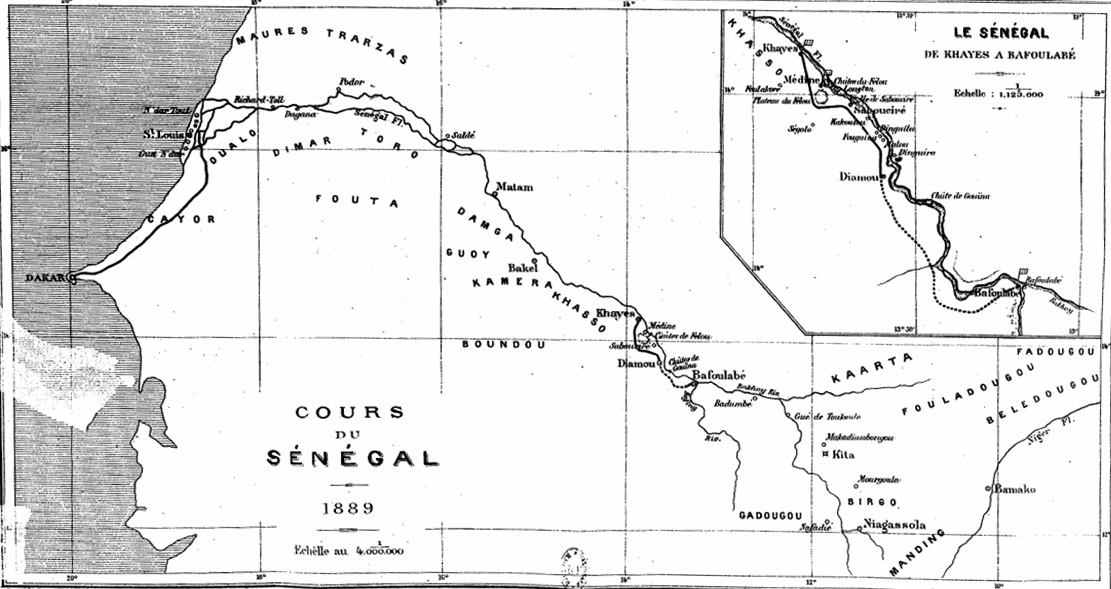
The Gouina Falls or ''Chutes de Gouina'' are on the Sénégal River in Mali between the towns of Bafoulabé (upstream) and Diamou (downstream) in the Kayes Region, where the river runs north from the Talari Gorges. They have been called the "Niagara falls of Mali". The river is about 500 m wide at this point, and drops 16 m over the falls. The volume of water is 12-13 m3 per second in the dry season, and up to 2430 m3 per second in the rainy season. The government of Mali and Senegal River Basin Development Authority has investigated the possibility of developing the electric power potential of the Senegal River. Downstream on the Félou Falls, a new Félou Hydroelectric Plant was completed in 2014. On Gouina Falls, construction of the 140 MW Gouina Hydroelectric Plant The Gouina Hydroelectric Plant is a run-of-the-river-type hydroelectric installation currently being constructed on Gouina Falls along the Senegal River in Mali. It is located about south ... [...More Info...] [...Related Items...] OR: [Wikipedia] [Google] [Baidu] |
Sénégal River
,french: Fleuve Sénégal) , name_etymology = , image = Senegal River Saint Louis.jpg , image_size = , image_caption = Fishermen on the bank of the Senegal River estuary at the outskirts of Saint-Louis, Senegal , map = Senegalrivermap.png , map_size = , map_caption = Map of the Senegal River drainage basin. , pushpin_map = , pushpin_map_size = , pushpin_map_caption= , subdivision_type1 = Country , subdivision_name1 = Senegal, Mauritania, Mali , subdivision_type2 = , subdivision_name2 = , subdivision_type3 = , subdivision_name3 = , subdivision_type4 = , subdivision_name4 = , subdivision_type5 = , subdivision_name5 = , length = , width_min = , width_avg = , width_max = , depth_min = , depth_avg = , depth_max = , discharge1_location= , discharge1_min = , discharge1_avg = , di ... [...More Info...] [...Related Items...] OR: [Wikipedia] [Google] [Baidu] |
Mali
Mali (; ), officially the Republic of Mali,, , ff, 𞤈𞤫𞤲𞥆𞤣𞤢𞥄𞤲𞤣𞤭 𞤃𞤢𞥄𞤤𞤭, Renndaandi Maali, italics=no, ar, جمهورية مالي, Jumhūriyyāt Mālī is a landlocked country in West Africa. Mali is the eighth-largest country in Africa, with an area of over . The population of Mali is million. 67% of its population was estimated to be under the age of 25 in 2017. Its capital and largest city is Bamako. The sovereign state of Mali consists of eight regions and its borders on the north reach deep into the middle of the Sahara Desert. The country's southern part is in the Sudanian savanna, where the majority of inhabitants live, and both the Niger and Senegal rivers pass through. The country's economy centres on agriculture and mining. One of Mali's most prominent natural resources is gold, and the country is the third largest producer of gold on the African continent. It also exports salt. Present-day Mali was once part of t ... [...More Info...] [...Related Items...] OR: [Wikipedia] [Google] [Baidu] |
Bafoulabé
Bafoulabé is a town and rural commune in south-western Mali. It is located in the Region of Kayes at the confluence of the Bafing and Bakoy rivers which join to become the Sénégal River. Bafoulabé is the capital of the Cercle of Bafoulabé, which in 1887 was the first Cercle to be created in Mali. Local administration Until the 1996 law creating communes, Bafoulabé Commune was an arrondissement. While now deprecated, the commune retains the same boundaries, extending far beyond the town of Bafoulabé, its seat (''chef-lieu''). Bafoulabé is also the seat of the larger Bafoulabé Cercle. Apart from the town, there are 28 villages, official rural subdivisions within the Commune. It is a ''Rural Commune'', meaning it is subdivided in villages, in contrast to the smaller ''Urban Commune'', divided into urban Quarters. Commune affairs are directed by an elected Commune Council (''conseil communal'') of 23 members and a Commune executive (''bureau communal'') of the elected M ... [...More Info...] [...Related Items...] OR: [Wikipedia] [Google] [Baidu] |
Diamou
Diamou is a town and commune in the Cercle of Kayes in the Kayes Region of south-western Mali. It is located 45 km from the city of Kayes on the left bank of the Sénégal River. The commune contains 25 villages,. and in the 2009 census had a population of 13,793. See also * Railway stations in Mali Railway stations in Mali include: Maps UN MapUNUNHCR Map Cities and Towns served by rail Existing * Dakar, Senegal - port * Tambacounda, Senegal (24m) * Goudiry (57m) * Kidira, Senegal (35m) - Mali border. * Kayes, Mali (20m) * Bafoul ... Note that there is another town in Mali with the same name. References External links *. Communes of Kayes Region {{Kayes-geo-stub ... [...More Info...] [...Related Items...] OR: [Wikipedia] [Google] [Baidu] |
Kayes Region
Kayes Region ( Bambara: ߞߊߦߌ ߘߌߣߋߖߊ tr. Kayi Dineja) is one of eight first level national subdivisions in Mali called Regions. It is the first administrative area of Mali and covers an area of . Its capital is the town of Kayes. The province was historically part of the Ghana Empire and the Mali Empire. Geography The region of Kayes is bordered to the north by Mauritania, to the west by Senegal, to the south by Guinea and to the east by the region of Koulikoro. In 2009 the region has a population of 1,996,812 inhabitants. Ethnic groups of the area include Soninkés, Khassonkés, Malinkés, Dialonkés, and Fulas (french: Peuls; ff, Fulɓe). Several rivers cross the region: the Baoulé, the Bafing, and the Bakoy which join at the town of Bafoulabé to form the Sénégal River. The Falls of Félou (15 km from Kayes), the Falls of Gouina (60 km to the south-east of Kayes on the Sénégal River), Talari Gorges, Lake Magui and Lake Doro are loca ... [...More Info...] [...Related Items...] OR: [Wikipedia] [Google] [Baidu] |
Talari Gorges
The Talari Gorges or ''Gorges de Talary'' are a series of gorges on the Sénégal River in Mali, between the towns of Bafoulabé (upstream) and Galougo (downstream) in the Kayes Region, at an altitude of about 75 meters or 249 feet above sea level. They are celebrated for their grandiose beauty. Downstream, to the north of the gorges are the spectacular Gouina Falls. The gorges are made from red sandstone, which is approximately 600 million years old. They are about wide and can be up to deep. References Talari Gorges The Talari Gorges or ''Gorges de Talary'' are a series of gorges on the Sénégal River in Mali Mali (; ), officially the Republic of Mali,, , ff, 𞤈𞤫𞤲𞥆𞤣𞤢𞥄𞤲𞤣𞤭 𞤃𞤢𞥄𞤤𞤭, Renndaandi Maali, italics=n ... Rivers of Mali {{Mali-river-stub ... [...More Info...] [...Related Items...] OR: [Wikipedia] [Google] [Baidu] |
Senegal River Basin Development Authority
Senegal,; Wolof: ''Senegaal''; Pulaar: 𞤅𞤫𞤲𞤫𞤺𞤢𞥄𞤤𞤭 (Senegaali); Arabic: السنغال ''As-Sinighal'') officially the Republic of Senegal,; Wolof: ''Réewum Senegaal''; Pulaar : 𞤈𞤫𞤲𞤣𞤢𞥄𞤲𞤣𞤭 𞤅𞤫𞤲𞤫𞤺𞤢𞥄𞤤𞤭 (Renndaandi Senegaali); Arabic: جمهورية السنغال ''Jumhuriat As-Sinighal'') is a country in West Africa, on the Atlantic Ocean coastline. Senegal is bordered by Mauritania to the north, Mali to the east, Guinea to the southeast and Guinea-Bissau to the southwest. Senegal nearly surrounds the Gambia, a country occupying a narrow sliver of land along the banks of the Gambia River, which separates Senegal's southern region of Casamance from the rest of the country. Senegal also shares a maritime border with Cape Verde. Senegal's economic and political capital is Dakar. Senegal is notably the westernmost country in the mainland of the Old World, or Afro-Eurasia. It owes its name to the Seneg ... [...More Info...] [...Related Items...] OR: [Wikipedia] [Google] [Baidu] |
Félou Falls
The Félou Falls (french: Chutes du Félou) are located on the Sénégal River upstream of Kayes in western Mali. The river tumbles down an irregular series of rocky steps. The waterfalls mark the furthest point from the mouth of the river that can be reached by boat. In 2009 work started on the construction of the Félou Hydroelectric Plant, a run-of-the-river hydroelectric plant at the falls replacing a small 600 kW plant dating from the 1920s. Historical significance The falls were historically important as they were the furthest point up the Sénégal River from Saint Louis that could be reached by boat. Because of the seasonal variation in the water level, navigation up to the falls was only possible for a few months after the rainy season. French forces made use of the river in their conquest of the Sudan in the 19th century. In 1855 Louis Faidherbe, the French governor of Sénégal, constructed a fort at the village of Médine, 3 km downstream of the falls, t ... [...More Info...] [...Related Items...] OR: [Wikipedia] [Google] [Baidu] |
Félou Hydroelectric Plant
The Félou Hydroelectric Plant is a hydroelectric installation at the Félou Falls on the Sénégal River in Mali. It has three water turbines capable of generating 62.3 MW. The current power station replaced an older one built in the 1920s. Construction of the new power station began in October 2009 and was financed by the World Bank. It is the third Senegal River Basin Development Authority project on the river and was completed in 2014. The existing weir was refurbished with the previous height maintained. In 1927, the previous hydroelectric power station was commissioned. It was refurbished in 1992 and had an installed capacity of 600 kW. At maximum output the three 21 MW turbines pass a total of of water. Between August and November the water flowing in the river generally exceeds this value allowing the plant to operate at full capacity and the excess water to pass over the weir. During the dry season (December to July) the electricity generated is reduced to ab ... [...More Info...] [...Related Items...] OR: [Wikipedia] [Google] [Baidu] |
Gouina Hydroelectric Plant
The Gouina Hydroelectric Plant is a run-of-the-river-type hydroelectric installation currently being constructed on Gouina Falls along the Senegal River in Mali. It is located about southeast of Diamou in the Kayes Region. It is the fourth project of the Senegal River Basin Development Authority and its ground-breaking ceremony on 17 December 2013 was attended by the heads of state of each member country. Mauritanian President Mohamed Ould Abdel Aziz laid the foundation stone. Preliminary construction had been suspended due to the 2012 Malian coup d'état and subsequent Northern Mali conflict. The plant is expected to be complete in 2020 and will provide power to Mauritania, Mali and Senegal. The plant will cost US$329 million and the of transmission lines will cost US$65 million. The project is receiving 85 percent of its funding from the Exim Bank of China along with US$1 million from the EU-Africa Infrastructure Trust Fund and US$1.4 million from the International Development ... [...More Info...] [...Related Items...] OR: [Wikipedia] [Google] [Baidu] |
Senegal River
,french: Fleuve Sénégal) , name_etymology = , image = Senegal River Saint Louis.jpg , image_size = , image_caption = Fishermen on the bank of the Senegal River estuary at the outskirts of Saint-Louis, Senegal , map = Senegalrivermap.png , map_size = , map_caption = Map of the Senegal River drainage basin. , pushpin_map = , pushpin_map_size = , pushpin_map_caption= , subdivision_type1 = Country , subdivision_name1 = Senegal, Mauritania, Mali , subdivision_type2 = , subdivision_name2 = , subdivision_type3 = , subdivision_name3 = , subdivision_type4 = , subdivision_name4 = , subdivision_type5 = , subdivision_name5 = , length = , width_min = , width_avg = , width_max = , depth_min = , depth_avg = , depth_max = , discharge1_location= , discharge1_min = , discharge1_avg = , di ... [...More Info...] [...Related Items...] OR: [Wikipedia] [Google] [Baidu] |


