|
Gnyozdovo
Gnyozdovo (russian: Гнёздово) is a village in Smolensky District, Smolensk Oblast, Russia, located on the right bank of the Dnieper River twelve kilometers downstream from Smolensk, in the proximity of Katyn. The village is noted for its extensive remains of a Slavic-Varangian settlement which flourished in the 10th century as a major trade station on the trade route from the Varangians to the Greeks, see Gnezdovo Gnezdovo or Gnyozdovo (russian: Гнёздово) is an archeological site located near the village of Gnyozdovo in Smolensky District, Smolensk Oblast, Russia. The site contains extensive remains of a Slavic-Varangian settlement that flourished i ... for details. External links Gnyozdovo, google maps Rural localities in Smolensk Oblast {{SmolenskOblast-geo-stub ... [...More Info...] [...Related Items...] OR: [Wikipedia] [Google] [Baidu] |
Gnezdovo
Gnezdovo or Gnyozdovo (russian: Гнёздово) is an archeological site located near the village of Gnyozdovo in Smolensky District, Smolensk Oblast, Russia. The site contains extensive remains of a Slavic-Varangian settlement that flourished in the 10th century as a major trade station on the trade route from the Varangians to the Greeks. Site The archaeological site comprises a "citadel" (''gorodishche'') (russian: Городище), formerly situated at the confluence of the Rivers Dnieper and Svinets, and a ring of ancient rural settlements (''selitba'') which occupy an area of 17.5 hectares, of which roughly had been excavated by the end of the 20th century. This makes the site one of the largest survivals of the Viking Age in Europe: only Hedeby covered a larger territory (24 hectares), with the sites of Birka (13 hectares), Dublin (12 hectares), Ribe (10 hectares), and Gdańsk (1 hectare) trailing behind. There are about 3,000 burial mounds ar ... [...More Info...] [...Related Items...] OR: [Wikipedia] [Google] [Baidu] |
Varangian
The Varangians (; non, Væringjar; gkm, Βάραγγοι, ''Várangoi'';Varangian " Online Etymology Dictionary : варяже, varyazhe or варязи, varyazi) were , conquerors, traders and settlers, mostly from . Between the 9th and 11th centuries, Varangians ruled the state of |
Types Of Settlements In Russia
The classification system of inhabited localities in Russia and some other post-Soviet states has certain peculiarities compared with those in other countries. Classes During the Soviet time, each of the republics of the Soviet Union, including the Russian SFSR, had its own legislative documents dealing with classification of inhabited localities. After the dissolution of the Soviet Union, the task of developing and maintaining such classification in Russia was delegated to the federal subjects.Articles 71 and 72 of the Constitution of Russia do not name issues of the administrative and territorial structure among the tasks handled on the federal level or jointly with the governments of the federal subjects. As such, all federal subjects pass their own laws establishing the system of the administrative-territorial divisions on their territories. While currently there are certain peculiarities to classifications used in many federal subjects, they are all still largely base ... [...More Info...] [...Related Items...] OR: [Wikipedia] [Google] [Baidu] |
Smolensky District, Smolensk Oblast
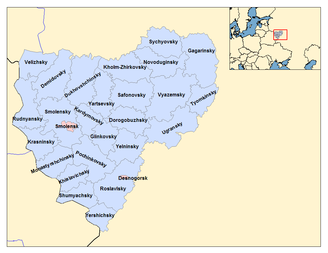
Smolensky District (russian: Смоле́нский райо́н) is an administrativeResolution #261 and municipalLaw #135-z district (raion), one of the twenty-five in Smolensk Oblast, Russia. It is located in the west of the oblast and borders with Demidovsky District in the north, Dukhovshchinsky District in the northeast, Kardymovsky District in the east, Pochinkovsky District in the south, Monastyrshchinsky District in the southwest, Krasninsky District in the west, and with Rudnyansky District in the northwest. The area of the district is . Its administrative center is the city of Smolensk (which is not administratively a part of the district). Population: 44,964 ( 2010 Census); Geography The district is split between the drainage basins of the Dnieper and the Daugava. The rivers in the northern part of the district flow into the Kasplya River, a left tributary of the Daugava. The Kasplya has its source in the district. The Dnieper crosses the district from east to west ... [...More Info...] [...Related Items...] OR: [Wikipedia] [Google] [Baidu] |
Smolensk Oblast
Smolensk Oblast (russian: Смоле́нская о́бласть, ''Smolenskaya oblast''; informal name — ''Smolenschina'' (russian: Смоле́нщина)) is a federal subject of Russia (an oblast). Its administrative centre is the city of Smolensk. As of the 2010 Census, its population was 985,537. Geography The oblast was founded on 27 September 1937.Исполнительный комитет Смоленского областного совета народных депутатов. Государственный архив Смоленской области. "Административно-территориальное устройство Смоленской области. Справочник", изд. "Московский рабочий", Москва 1981. Стр. 8 It borders Pskov Oblast in the north, Tver Oblast in the northeast, Moscow Oblast in the east, Kaluga Oblast in south, Bryansk Oblast in the southwest, and Mogilev and Vitebsk Oblast ... [...More Info...] [...Related Items...] OR: [Wikipedia] [Google] [Baidu] |
Russia
Russia (, , ), or the Russian Federation, is a List of transcontinental countries, transcontinental country spanning Eastern Europe and North Asia, Northern Asia. It is the List of countries and dependencies by area, largest country in the world, with its internationally recognised territory covering , and encompassing one-eighth of Earth's inhabitable landmass. Russia extends across Time in Russia, eleven time zones and shares Borders of Russia, land boundaries with fourteen countries, more than List of countries and territories by land borders, any other country but China. It is the List of countries and dependencies by population, world's ninth-most populous country and List of European countries by population, Europe's most populous country, with a population of 146 million people. The country's capital and List of cities and towns in Russia by population, largest city is Moscow, the List of European cities by population within city limits, largest city entirely within E ... [...More Info...] [...Related Items...] OR: [Wikipedia] [Google] [Baidu] |
Dnieper River
} The Dnieper () or Dnipro (); , ; . is one of the major transboundary rivers of Europe, rising in the Valdai Hills near Smolensk, Russia, before flowing through Belarus and Ukraine to the Black Sea. It is the longest river of Ukraine and Belarus and the fourth-longest river in Europe, after the Volga, Danube, and Ural rivers. It is approximately long, with a drainage basin of . In antiquity, the river was part of the Amber Road trade routes. During the Ruin in the later 17th century, the area was contested between the Polish–Lithuanian Commonwealth and Russia, dividing Ukraine into areas described by its right and left banks. During the Soviet period, the river became noted for its major hydroelectric dams and large reservoirs. The 1986 Chernobyl disaster occurred on the Pripyat, immediately above that tributary's confluence with the Dnieper. The Dnieper is an important navigable waterway for the economy of Ukraine and is connected by the Dnieper–Bug Canal to other ... [...More Info...] [...Related Items...] OR: [Wikipedia] [Google] [Baidu] |
Smolensk
Smolensk ( rus, Смоленск, p=smɐˈlʲensk, a=smolensk_ru.ogg) is a city and the administrative center of Smolensk Oblast, Russia, located on the Dnieper River, west-southwest of Moscow. First mentioned in 863, it is one of the oldest cities in Russia. Population: The city has been destroyed several times throughout its long history because it was on the invasion routes of various empires. Smolensk is known for its electronics, textiles, food processing, and diamond faceting industries. Etymology The name of the city is derived from the name of the Smolnya River. Smolnya river flows through Karelian and Murmansk areas of north-western Russia. The origin of the river's name is less clear. One possibility is the old Slavic word () for black soil, which might have colored the waters of the Smolnya. An alternative origin could be the Russian word (), which means resin, tar, or pitch. Pine trees grow in the area, and the city was once a center of resin processing and t ... [...More Info...] [...Related Items...] OR: [Wikipedia] [Google] [Baidu] |
Katyn (rural Locality)
Katyn (russian: Кáтынь; pl, Katyń ) is a rural locality (a '' selo'') in Smolensky District of Smolensk Oblast, Russia, located approximately to the west of Smolensk, the administrative center of the oblast. The village had a population of 1,737 in 2007. Geography It is situated to the west of the city of Smolensk (about 18 km from its center) and circa 60 km from the Russian borders with Belarus. It has a station on the Berlin-Warsaw-Minsk-Moscow international railway line. Climate Katyn has a warm-summer humid continental climate (''Dfb'' in the Köppen climate classification). History Before World War I, Gnezdovo with the Katyn Forest belonged to the Koźliński family. In the 19th century, Piotr Koźliński married Leokadia Lefftreu, the daughter of the director of the English railway construction company in Russia. Under the marriage articles Gniezdovo and Katyn became co-owned by the British. Katyn massacre The Katyn Forest, in the vicinity of the vi ... [...More Info...] [...Related Items...] OR: [Wikipedia] [Google] [Baidu] |
Trade Route From The Varangians To The Greeks
The trade route from the Varangians to the Greeks was a medieval trade route that connected Scandinavia, Kievan Rus' and the Eastern Roman Empire. The route allowed merchants along its length to establish a direct prosperous trade with the Empire, and prompted some of them to settle in the territories of present-day Belarus, Russia and Ukraine. The majority of the route comprised a long-distance waterway, including the Baltic Sea, several rivers flowing into the Baltic Sea, and rivers of the Dnieper river system, with portages on the drainage divides. An alternative route was along the Dniestr river with stops on the Western shore of Black Sea. These more specific sub-routes are sometimes referred to as the Dnieper trade route and Dniestr trade route, respectively. The route began in Scandinavian trading centers such as Birka, Hedeby, and Gotland, the eastern route crossed the Baltic Sea, entered the Gulf of Finland, and followed the Neva River into Lake Ladoga. Then it follo ... [...More Info...] [...Related Items...] OR: [Wikipedia] [Google] [Baidu] |


