|
Gimmelwald
Gimmelwald is a small traffic free village in the Bernese Oberland in the Canton of Bern, Switzerland, and is located between Stechelberg and Mürren, at an elevation of 1363 meters (4472 feet). The village is at the foot of the UNESCO World Heritage site the Jungfrau-Aletsch Protected Area. Gimmelwald is an allemanic linear village and a walser settlement first mentioned in a bill of sale in 1346. Because of its very typical and exceptional townscape, Gimmelwald is part of the inventory of Swiss heritage. Gimmelwald is one of the few traffic-free villages in Switzerland where access by car is not possible due to a missing road connection. The Schilthorn cable car stops in Gimmelwald, where it is possible to board another cable car which runs between Gimmelwald and Mürren. Farming and tourism are the main source of income today. Farmers raise hay on tiny plots of land to feed small herds of cows. In winter, farmers often work as well for the Schilthorn cable car by performing job ... [...More Info...] [...Related Items...] OR: [Wikipedia] [Google] [Baidu] |
Lauterbrunnen
, neighboring_municipalities= Aeschi bei Spiez, Blatten (Lötschen) (VS), Fieschertal (VS), Grindelwald, Gündlischwand, Kandersteg, Lütschental, Reichenbach im Kandertal, Saxeten, Wilderswil , twintowns = } Lauterbrunnen is a village and Municipalities of Switzerland, municipality in the Interlaken-Oberhasli (administrative district), Interlaken-Oberhasli administrative district in the Cantons of Switzerland, canton of Canton of Bern, Bern in Switzerland. The municipality comprises the other villages of Wengen, Mürren, Gimmelwald, Stechelberg and Isenfluh, as well as several other hamlets. The population of the village of Lauterbrunnen is less than that of Wengen, but larger than that of the others. The municipality comprises the Lauterbrunnen Valley (german: Lauterbrunnental), located at the foot of the Bernese Alps. It is notably overlooked by the Eiger, Mönch and Jungfrau and many other high peaks. The valley, drained by the White Lütschine, comprehends the Soustal, t ... [...More Info...] [...Related Items...] OR: [Wikipedia] [Google] [Baidu] |
Mürren
Mürren is a traditional Walser mountain village in the Bernese Highlands of Switzerland, at an elevation of above sea level and it cannot be reached by public road. It is also one of the popular tourist spots in Switzerland, and summer and winter are the seasons when Mürren becomes busy with tourists. The village features a view of the three towering mountains Eiger, Mönch, and Jungfrau. Mürren has a year-round population of 450, but has 2,000 hotel beds. Mürren has its own school and two churches, one Reformed and one Roman Catholic. Transport Mürren station is the terminus of the Bergbahn Lauterbrunnen-Mürren, which consists of a cable car and a connecting narrow gauge railway, it connects Mürren to Lauterbrunnen. A series of four cable cars, known as the ''Luftseilbahn Stechelberg-Mürren-Schilthorn (LSMS)'', provides transportation from Mürren downhill to Gimmelwald and Stechelberg, and uphill to the summit of the Schilthorn and the revolving restaurant Pi ... [...More Info...] [...Related Items...] OR: [Wikipedia] [Google] [Baidu] |
Isenfluh
Isenfluh is a hamlet in Switzerland, north of the road from Wilderswil to Lauterbrunnen. It is first mentioned in 1319 as ''Ysenfluo'' and in 1401 people from the Lötschental started to settle in the small hamlet. The hamlet belonged to the monastery in Interlaken since the 14th century was administered by the bailiff of Interlaken from 1528 to 1798. In 1973, Isenfluh, together with Wengen, Muerren, Gimmelwald, Stechelberg and Lauterbrunnen, became part of the municipality of Lauterbrunnen. The infrastructure of Isenfluh is installed, but a lot of the support comes from self-help groups. Since the village school was closed for financial reasons by the government of the Canton of Bern, the children of Isenfluh attend school in Lauterbrunnen. The main road (and bus route), Churchischlief, to Isenfluh traverses a spiral tunnel. This opened in 1992 and replaced a previous mountain road destroyed by a 1987 landslide. Isenfluh is a base for hiking and sleigh-rides and ice-climbi ... [...More Info...] [...Related Items...] OR: [Wikipedia] [Google] [Baidu] |
Schilthorn
The Schilthorn () is a summit in Europe, in the Bernese Alps of Switzerland. It overlooks the valley of Lauterbrunnen in the Bernese Oberland, and is the highest mountain in the range lying north of the Sefinenfurgge Pass. The Schilthorn lies above the village of Mürren, from where a cable car leads to its summit. Administratively, the summit is within the municipality of Lauterbrunnen, although the western slopes are within the municipality of Reichenbach im Kandertal. Both municipalities are in the canton of Bern. The summit has a panoramic view which spans from the Titlis, Jungfrau, Mönch, Eiger, over the Bernese Alps and the Jura mountains up to the Vosges Mountains and the Black Forest. Mont Blanc is also just visible. Access To get to the Schilthorn from the valley floor, a series of cable cars must be taken. The cable cars begin in Stechelberg leaving to Gimmelwald and then onto Mürren. From Mürren another cable car is taken to Birg, which is the final change ... [...More Info...] [...Related Items...] OR: [Wikipedia] [Google] [Baidu] |
Inventory Of Swiss Heritage Sites
The Federal Inventory of Heritage Sites (ISOS) is part of a 1981 Ordinance of the Swiss Federal Council implementing the Federal Law on the Protection of Nature and Cultural Heritage. Sites of national importance Types The types are based on the Ordinance and consolidated/translated as follows: *city: german: Stadt, Stadt/Flecken, it, città, french: ville *town: german: Kleinstadt, Kleinstadt (Flecken), it, borgo, borgo/cittadina, french: petite ville *urbanized village: german: verstädtertes Dorf, it, villaggio urbanizzato, french: village urbanisé, rm, vischnanca urbanisada *village: german: Dorf, it, villaggio, french: village, rm, vischnanca *hamlet: german: Weiler, it, frazione, frazione (casale), french: hameau, rm, aclaun *special case: german: Spezialfall, it, caso particolare, french: cas particulier, cas spécial, rm, cas spezial References * External links ISOS* {{DEFAULTSORT:Heritage Sites Heritage registers in Switzerland Switzerland geograph ... [...More Info...] [...Related Items...] OR: [Wikipedia] [Google] [Baidu] |
Wengen, Switzerland
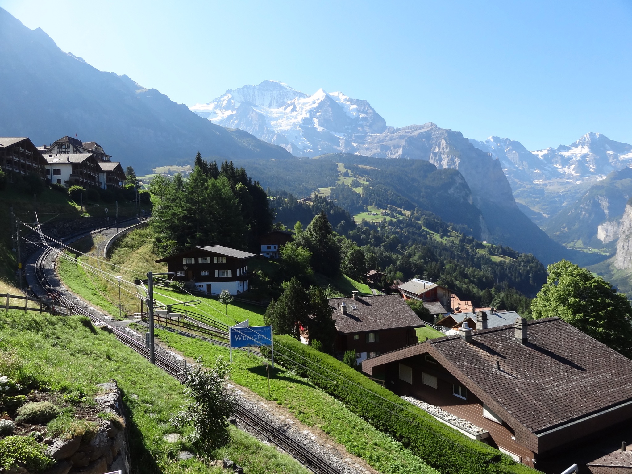
Wengen () is a mountain village in the Bernese Oberland of central Switzerland. Located in the canton of Bern at an elevation of above sea level, it is part of the Jungfrauregion and has approximately 1,300 year-round residents, which swells to 5,000 during summer and to 10,000 in the winter. Wengen hosts the classic Lauberhorn ski races of the FIS Alpine Ski World Cup in January. History Wengen was first mentioned in official documents in 1268, and the origin of the name is unknown. Primarily an alpine farming community, the village began to be visited by tourists in the early 19th century. Mary and Percy Bysshe Shelley's ''History of a Six Weeks' Tour'' and Byron's ''Manfred'', in which the scenery of the area is described, were published in 1817. This literature became the advent of the modern tourism industry for the village. Felix Mendelssohn, to whom there is a memorial above the village, also visited in the early nineteenth century. Guesthouses and hotels began to be b ... [...More Info...] [...Related Items...] OR: [Wikipedia] [Google] [Baidu] |
Wengen
Wengen () is a mountain village in the Bernese Oberland of central Switzerland. Located in the canton of Bern at an elevation of above sea level, it is part of the Jungfrauregion and has approximately 1,300 year-round residents, which swells to 5,000 during summer and to 10,000 in the winter. Wengen hosts the classic Lauberhorn ski races of the FIS Alpine Ski World Cup in January. History Wengen was first mentioned in official documents in 1268, and the origin of the name is unknown. Primarily an alpine farming community, the village began to be visited by tourists in the early 19th century. Mary and Percy Bysshe Shelley's ''History of a Six Weeks' Tour'' and Byron's '' Manfred'', in which the scenery of the area is described, were published in 1817. This literature became the advent of the modern tourism industry for the village. Felix Mendelssohn, to whom there is a memorial above the village, also visited in the early nineteenth century. Guesthouses and hotels began to b ... [...More Info...] [...Related Items...] OR: [Wikipedia] [Google] [Baidu] |
Cooperative
A cooperative (also known as co-operative, co-op, or coop) is "an autonomous association of persons united voluntarily to meet their common economic, social and cultural needs and aspirations through a jointly owned and democratically-controlled enterprise".Statement on the Cooperative Identity. ''.'' Cooperatives are democratically controlled by their members, with each member having one vote in electing the board of directors. Cooperatives may include: * businesses owned and managed by the people who consume th ... [...More Info...] [...Related Items...] OR: [Wikipedia] [Google] [Baidu] |
Villages In The Canton Of Bern
A village is a clustered human settlement or community, larger than a hamlet but smaller than a town (although the word is often used to describe both hamlets and smaller towns), with a population typically ranging from a few hundred to a few thousand. Though villages are often located in rural areas, the term urban village is also applied to certain urban neighborhoods. Villages are normally permanent, with fixed dwellings; however, transient villages can occur. Further, the dwellings of a village are fairly close to one another, not scattered broadly over the landscape, as a dispersed settlement. In the past, villages were a usual form of community for societies that practice subsistence agriculture, and also for some non-agricultural societies. In Great Britain, a hamlet earned the right to be called a village when it built a church. [...More Info...] [...Related Items...] OR: [Wikipedia] [Google] [Baidu] |
Gspaltenhorn
The Gspaltenhorn is a mountain of the Bernese Alps, located between the valleys of Kiental and Lauterbrunnen in the canton of Bern german: Berner(in)french: Bernois(e) it, bernese , neighboring_municipalities = Bremgarten bei Bern, Frauenkappelen, Ittigen, Kirchlindach, Köniz, Mühleberg, Muri bei Bern, Neuenegg, Ostermundigen, Wohlen bei Bern, Zollikofen , website .... With an elevation of 3,436 metres above sea level, the Gspaltenhorn is the highest summit of the range lying north-east of the Gamchilück pass (2,837 m). References External links Gspaltenhorn on Hikr Bernese Alps Mountains of the Alps [...More Info...] [...Related Items...] OR: [Wikipedia] [Google] [Baidu] |
Jungfrau
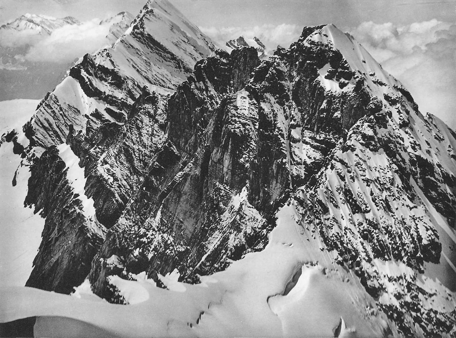
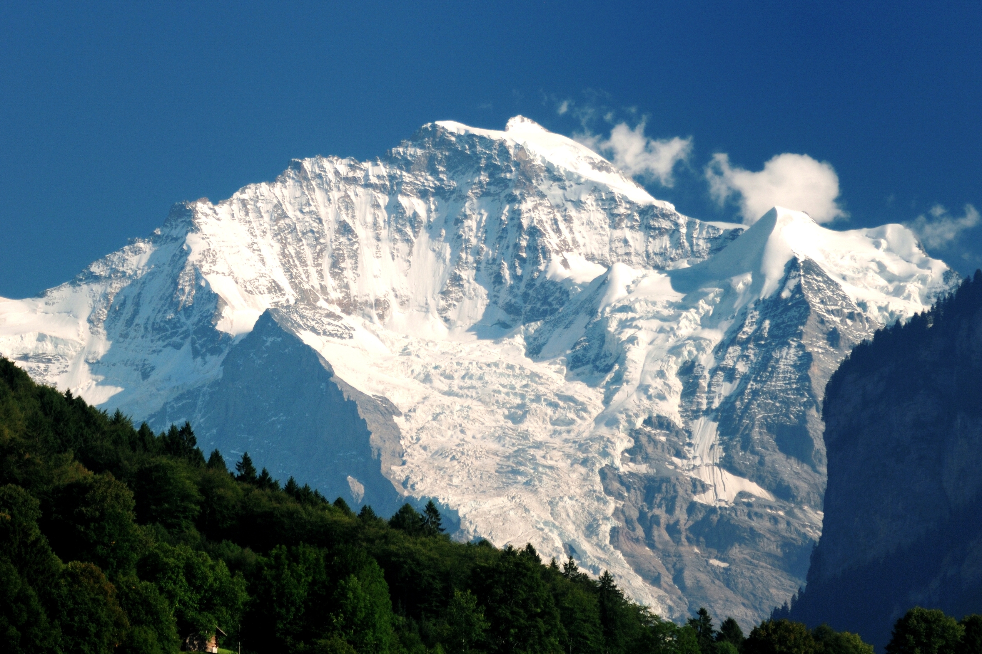
The Jungfrau ( "maiden, virgin"), at is one of the main summits of the Bernese Alps, located between the northern canton of Bern and the southern canton of Valais, halfway between Interlaken and Fiesch. Together with the Eiger and Mönch, the Jungfrau forms a massive wall of mountains overlooking the Bernese Oberland and the Swiss Plateau, one of the most distinctive sights of the Swiss Alps. The summit was first reached on August 3, 1811, by the Meyer brothers of Aarau and two chamois hunters from Valais. The ascent followed a long expedition over the glaciers and high passes of the Bernese Alps. It was not until 1865 that a more direct route on the northern side was opened. The construction of the Jungfrau Railway in the early 20th century, which connects Kleine Scheidegg to the Jungfraujoch, the saddle between the Mönch and the Jungfrau, made the area one of the most-visited places in the Alps. Along with the Aletsch Glacier to the south, the Jungfrau is part of the Jungf ... [...More Info...] [...Related Items...] OR: [Wikipedia] [Google] [Baidu] |
Via Ferrata
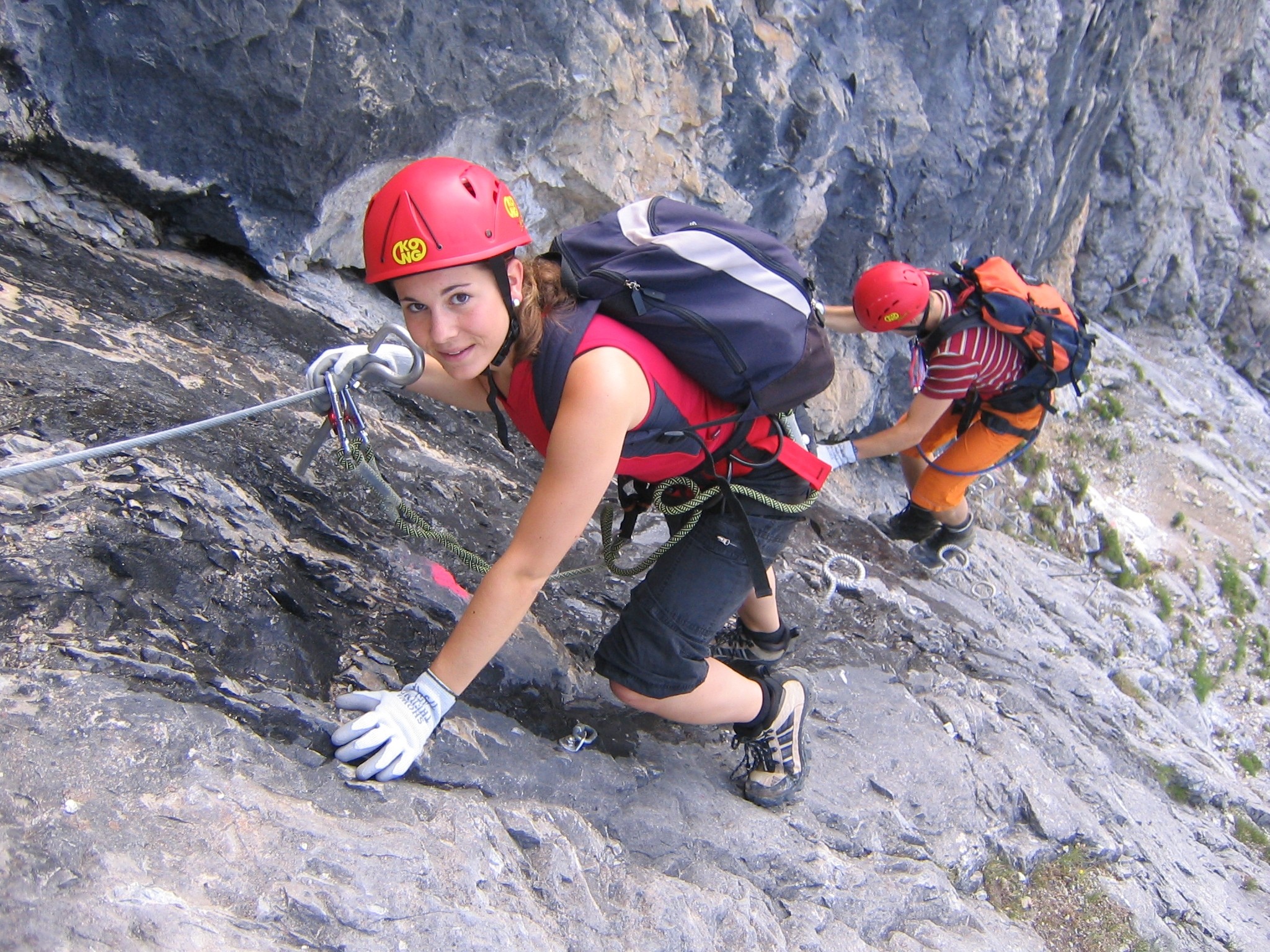
A via ferrata (Italian for "iron path", plural ''vie ferrate'' or in English ''via ferratas'') is a protected climbing route found in the Alps and certain other locations. The term "via ferrata" is used in most countries and languages except notably in German-speaking regions, which use ''Klettersteig''—"climbing path" (plural ''Klettersteige''). Infrastructure A via ferrata is a climbing route that employs steel cables, rungs or ladders, fixed to the rock to which the climbers affix a harness with two leashes, which allows the climbers to secure themselves to the metal fixture and limit any fall. The cable and other fixtures, such as iron rungs (stemples), pegs, carved steps, and ladders and bridges, provide both footings and handholds, as well. This allows climbing on otherwise dangerous routes without the risks of unprotected scrambling and climbing or the need for technical climbing equipment. They expand the opportunities for accessing difficult peaks as an alternative ... [...More Info...] [...Related Items...] OR: [Wikipedia] [Google] [Baidu] |


