|
Geography Of Jersey
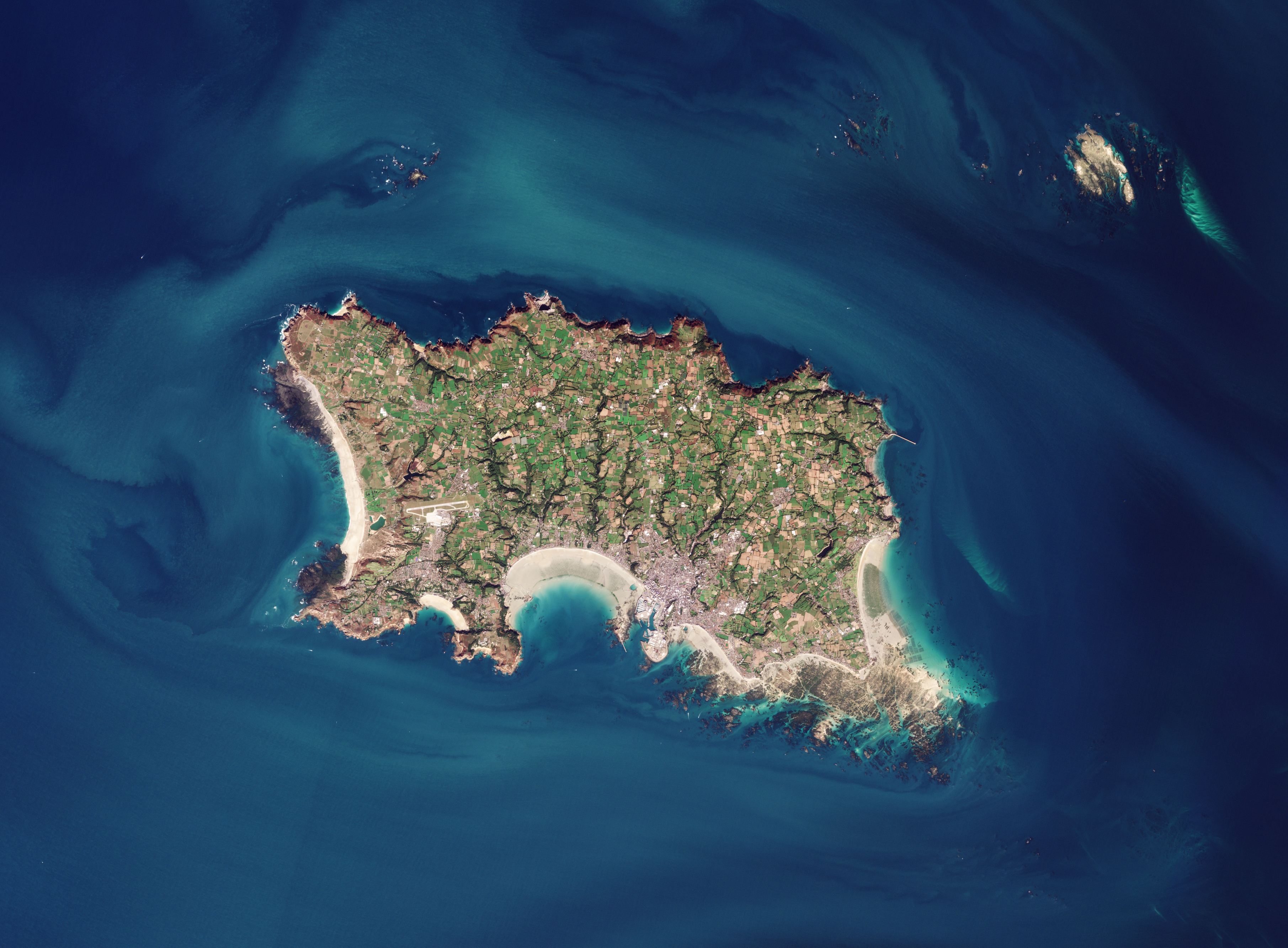
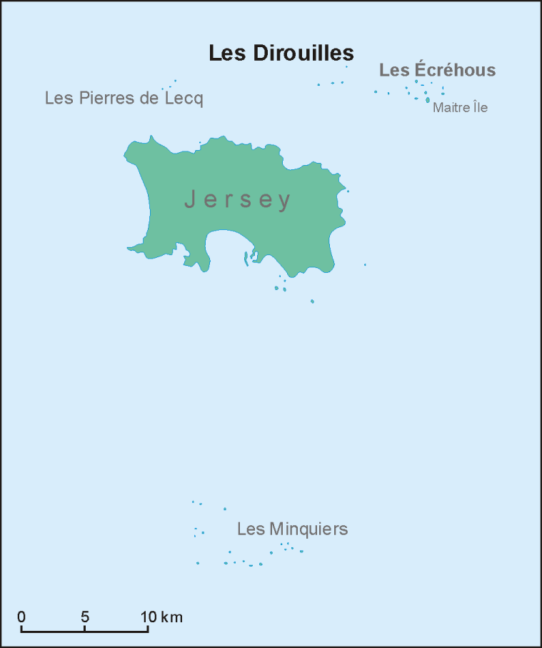
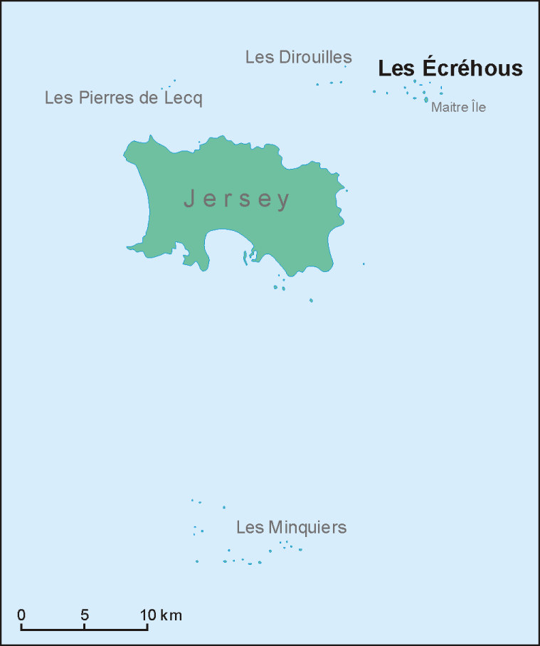
Jersey (Jèrriais: ''Jèrri'') is the largest of the Channel Islands, an island archipelago in the St. Malo bight in the western English Channel. It has a total area of 120 square kilometres (45 sq mi) and is part of the British Isles archipelago. It lies 22 km (12 nmi; 14 mi) from the Cotenin Peninsula in Normandy, France and about 161 km (87 nmi; 100 mi) from the south coast of Great Britain. Jersey lies within longitude -2° W and latitude 49° N. It has a coastline of 70 kilometres and no land connections to any other territories. Jersey claims a territorial sea of and an exclusive fishing zone of and shares maritime borders with the Bailiwick of Guernsey to the north and France to the south and east. Jersey is the main island of the Bailiwick of Jersey, which also consists of islet groups known as Les Écréhous, Les Minquiers, Les Dirouilles and Les Pierres de Lecq. It is a highly densely populated territory, being the 13th most densely populated ... [...More Info...] [...Related Items...] OR: [Wikipedia] [Google] [Baidu] |
English Channel
The English Channel, "The Sleeve"; nrf, la Maunche, "The Sleeve" (Cotentinais) or ( Jèrriais), (Guernésiais), "The Channel"; br, Mor Breizh, "Sea of Brittany"; cy, Môr Udd, "Lord's Sea"; kw, Mor Bretannek, "British Sea"; nl, Het Kanaal, "The Channel"; german: Ärmelkanal, "Sleeve Channel" ( French: ''la Manche;'' also called the British Channel or simply the Channel) is an arm of the Atlantic Ocean that separates Southern England from northern France. It links to the southern part of the North Sea by the Strait of Dover at its northeastern end. It is the busiest shipping area in the world. It is about long and varies in width from at its widest to at its narrowest in the Strait of Dover."English Channel". ''The Columbia Encyclopedia'', 2004. It is the smallest of the shallow seas around the continental shelf of Europe, covering an area of some . The Channel was a key factor in Britain becoming a naval superpower and has been utilised by Britain as a natural def ... [...More Info...] [...Related Items...] OR: [Wikipedia] [Google] [Baidu] |
Storm Ciara
Storm Ciara was a powerful and long-lived extratropical cyclone that was the first of a pair of European windstorms to affect the United Kingdom and Ireland at peak intensity less than a week apart in early February 2020, followed by Storm Dennis a week later. Ciara caused widespread wind and flooding damage across Europe, and at least 13 fatalities. The system emerged into the North Atlantic and underwent explosive cyclogenesis; the first severe weather warnings were issued for the United Kingdom and Ireland on 4 February well in advance of the storm's arrival. It was officially named ''Ciara'' by the Met Office the following day, becoming the twelfth named storm of the 2019–20 European windstorm season. Ciara subsequently made landfall in northern Scotland on 9 February and Norway the next day. Precursor low Named Winter Storm ''Kade'' by the weather channel brought heavy snowfall to the northern United States and eastern Canada, especially Newfoundland, New England and Ne ... [...More Info...] [...Related Items...] OR: [Wikipedia] [Google] [Baidu] |
Sand Dune
A dune is a landform composed of wind- or water-driven sand. It typically takes the form of a mound, ridge, or hill. An area with dunes is called a dune system or a dune complex. A large dune complex is called a dune field, while broad, flat regions covered with wind-swept sand or dunes with little or no vegetation are called ''ergs'' or ''sand seas''. Dunes occur in different shapes and sizes, but most kinds of dunes are longer on the stoss (upflow) side, where the sand is pushed up the dune, and have a shorter ''slip face'' in the lee side. The valley or trough between dunes is called a ''dune slack''. Dunes are most common in desert environments, where the lack of moisture hinders the growth of vegetation that would otherwise interfere with the development of dunes. However, sand deposits are not restricted to deserts, and dunes are also found along sea shores, along streams in semiarid climates, in areas of glacial outwash, and in other areas where poorly cemented san ... [...More Info...] [...Related Items...] OR: [Wikipedia] [Google] [Baidu] |
Headland
A headland, also known as a head, is a coastal landform, a point of land usually high and often with a sheer drop, that extends into a body of water. It is a type of promontory. A headland of considerable size often is called a cape.Whittow, John (1984). ''Dictionary of Physical Geography''. London: Penguin, 1984, pp. 80, 246. . Headlands are characterised by high, breaking waves, rocky shores, intense erosion, and steep sea cliff. Headlands and bays are often found on the same coastline. A bay is flanked by land on three sides, whereas a headland is flanked by water on three sides. Headlands and bays form on discordant coastlines, where bands of rock of alternating resistance run perpendicular to the coast. Bays form when weak (less resistant) rocks (such as sands and clays) are eroded, leaving bands of stronger (more resistant) rocks (such as chalk, limestone, and granite) forming a headland, or peninsula. Through the deposition of sediment within the bay and the erosion of the ... [...More Info...] [...Related Items...] OR: [Wikipedia] [Google] [Baidu] |
Saint Clement, Jersey
St Clement (Jèrriais: ''Saint Cliément'') is one of the twelve parishes of Jersey in the Channel Islands. Its parish hall is around south-east of St Helier. The parish has a population of 9,221 and is the second most densely populated. Located on the south-east coast of the island, stretching from Le Dicq in the west to near La Rocque in the east, it is the smallest parish, with a surface area of just 2,440 vergées (4 km2). The parish is largely suburbanised, with a large spread of post-war low-density housing development. There is no easily definable centre to the parish. The parish hall, schools and church are located in different areas. The parish is also home to a number of sports facilities, such as FB Fields and St Clement's Golf Club. Topynomy In pre-Norman times, the area now known as St Clement was known as ''Petravilla'' or ''Pierreville''. This is named for Peter, a monk who gave his lands in St Clement to the Mont Saint-Michel abbey. The modern parish der ... [...More Info...] [...Related Items...] OR: [Wikipedia] [Google] [Baidu] |
Les Platons
Les Platons is the highest point of Jersey, a British Crown dependency, with an elevation of 136 metres (446 ft). It is located in the Vingtaine de la Ville-à-l'Évêque in the parish of Trinity. There are radio transmitters, and a radar station located at Les Platons. In October 1955, Les Platons was used as a site for a television transmitter to bring BBC Television (later renamed BBC One) transmissions to the Channel Islands. It transmitted BBC Television on the VHF 405 line service on channel 4 from Monday 3 October 1955. From 1955 the site was also used to bring the BBC national radio stations to the Channel Islands. Before 1955 the Channel Islands had no transmitters, and received radio transmissions of the BBC national radio stations from mainland England. The BBC started FM transmissions on 16 October 1961 from Les Platons, of the Home, Light and Third Programmes (had started in the UK in the mid-to-late 1950s). Later this became 91.1 as Radio 2 (with occ ... [...More Info...] [...Related Items...] OR: [Wikipedia] [Google] [Baidu] |
Les Dirouilles
Les Dirouilles ( nrf, label=Jèrriais, Les Dithouïl'yes) are a range of rocks to the North-East of Jersey Jersey ( , ; nrf, Jèrri, label=Jèrriais ), officially the Bailiwick of Jersey (french: Bailliage de Jersey, links=no; Jèrriais: ), is an island country and self-governing Crown Dependencies, Crown Dependency near the coast of north-west F .... Historically and administratively, they belong to the parish of Saint Martin. They have a large range of names, taken individually, and are also known as just ''Les Pièrres'' (the rocks).R RamsarLesEcrehousManagementPlan (size 1Mb) DM 02022012.pdf References External linksLes Dithouïl'yes with lists of names Dirouilles Dirouilles Wetlands of the Channel Islands {{Jersey-geo-stub ... [...More Info...] [...Related Items...] OR: [Wikipedia] [Google] [Baidu] |
Pierres De Lecq
Les Pierres de Lecq (Jèrriais: ''Les Pièrres dé Lé'') or the Paternosters are a group of uninhabitable rocks or a reef in the Bailiwick of Jersey between Jersey and Sark, north of Grève de Lecq in Saint Mary, and west of the Cotentin Peninsula in Normandy. Only three or four of the rocks remain visible at high tide: L'Êtaîthe (the eastern one), La Grôsse (the big one) and La Vouêtaîthe (the western one). The area has one of the greatest tidal ranges in the world, sometimes being as much as . The name ''Paternosters'' is connected with a legend relating to the colonisation of Sark in the 16th century. According to this legend a boatload of women and children was wrecked on the reef and their cries can still be heard from time to time in the wind. Superstitious sailors would say the Lord's Prayer when passing the rocks, hence the name ''Paternosters''. The rocks are considered to form a biogeographical boundary between a cold and a warmer part of the ocean. Together w ... [...More Info...] [...Related Items...] OR: [Wikipedia] [Google] [Baidu] |
Minquiers
The Minquiers (''Les Minquiers''; in Jèrriais: ''Les Mîntchièrs'' ; known as "the Minkies" in local English) are a group of islands and rocks, about south of Jersey. They form part of the Bailiwick of Jersey. They are administratively part of the Parish of Grouville, and of its Vingtaine La Rocque. The rock shelf around the Minquiers has a larger surface area than Jersey itself, but at high tide only a few of the main heads remain above water. The largest of these is Maîtresse, which is about long and wide and has about ten stone cottages in various states of repair. These are the most southerly buildings in the British Isles; but they have no permanent inhabitants; though fishermen, vraic (seaweed used for fertilizer) collectors, yachtsmen, kayakers, and even radio amateurs make summer landfall. Name The etymology of the name is disputed, and could either come from the Breton language ''minihi'' meaning a sanctuary, or from ''minkier'' meaning a seller of fish. Geography ... [...More Info...] [...Related Items...] OR: [Wikipedia] [Google] [Baidu] |
Écréhous
The Écréhous (or in Jèrriais: ''Êcrého'') are a group of islands and rocks situated six miles (9.6 km) north-east of Jersey, and eight miles (12.8 km) from France. They form part of the Bailiwick of Jersey and are administratively part of the Parish of Saint Martin, Jersey, St. Martin. Etymology The name 'Ecrehous' is old Norse language, Norse in origin. "Esker" as in Skerry meaning a stony bank and '-hou, Hou', the toponym found also in Jethou, Lihou, Brecqhou, Burhou and other islets, derives from ''holm'', meaning ''island''. The first part of the name appears to be traced back to the Norse word ''sker'', meaning ''reef''. The Ecrehos are actually, geologically, part of the same island group as Les Dirouilles (west) and Les Pierres de Lecq ('the Paternosters') (further west). Islets The most significant islets in the group are: *Maîtr'Île *La Marmotchiéthe ('La Marmotière' in French language, gallicized form) *Lé Bliantch'Île (''La Blanche Île'' in gallic ... [...More Info...] [...Related Items...] OR: [Wikipedia] [Google] [Baidu] |
List Of Islands Of The Bailiwick Of Jersey
The Bailiwick of Jersey (Jèrriais: ''Bailliage dé Jèrri'') is a British Crown dependency off the French coast of Normandy. As well as the island of Jersey itself, the Bailiwick includes the nearly uninhabited islands and islets of: * Les Minquiers ** Maîtresse Île / Maîtr' Île ** Les Maisons ** Le Niêsant ** Les Faucheurs ** La Haute Grune * Les Écréhous ** Maîtr'Île ** La Marmotchiéthe ** Lé Bliantch'Île ** Les D'mies ** La Grand' Naithe ** L'Êtchièrviéthe ** Lé Fou ** La Froutchie * Les Dirouilles * Les Pierres de Lecq ** ''L'Êtchièrviéthe'' ** ''La Rocque du Nord'' ** '' L'Êtaîse'' or ''L'Êtaîthe'' ** ''Lé Bel'' ** ''Lé Longis '' ** ''La P'tite Mathe'' ** '' La Grôsse '' (Great Rock) ** ''La Grand' Mathe'' ** ''La Greune dé Lé'', or ''La Bonnette '' ** ''La Greune du Seur-Vouêt'' ** ''L'Orange'' ** ''La Vouêtaîse'', ''La Vouêtaîthe'', or ''La Vouêt'rêsse'' ** ''La Cappe '' ** ''La Douoche'' ** '' Lé Byi '' ** ''La Rocque Mollet ... [...More Info...] [...Related Items...] OR: [Wikipedia] [Google] [Baidu] |


