|
Geography Of Estonia
Between 57.3 and 59.5 latitude and 21.5 and 28.1 longitude, Estonia lies on the eastern coast of the Baltic Sea on the level northwestern part of the rising East European Platform. Estonia's continental mainland is bordered to the north by the Gulf of Finland (part of the Baltic Sea) across from Finland, to the east by Lake Peipus and Russia, and to the south by Latvia. Besides the part of the European continent, Estonian territory also includes the larger islands of Saaremaa and Hiiumaa, and over 2,200 other islands and islets in the Baltic Sea, off the western and northern shores of the country's mainland. Average elevation in Estonia reaches . The climate is maritime, wet, with moderate winters and cool summers. Oil shale and limestone deposits, along with forests which cover 47% of the land, play key economic roles in this generally resource-poor country. Estonia boasts over 1,500 lakes, numerous bogs, and 3,794 kilometers of coastline marked by numerous bays, straits, and ... [...More Info...] [...Related Items...] OR: [Wikipedia] [Google] [Baidu] |
Europe
Europe is a large peninsula conventionally considered a continent in its own right because of its great physical size and the weight of its history and traditions. Europe is also considered a Continent#Subcontinents, subcontinent of Eurasia and it is located entirely in the Northern Hemisphere and mostly in the Eastern Hemisphere. Comprising the westernmost peninsulas of Eurasia, it shares the continental landmass of Afro-Eurasia with both Africa and Asia. It is bordered by the Arctic Ocean to the north, the Atlantic Ocean to the west, the Mediterranean Sea to the south and Asia to the east. Europe is commonly considered to be Boundaries between the continents of Earth#Asia and Europe, separated from Asia by the drainage divide, watershed of the Ural Mountains, the Ural (river), Ural River, the Caspian Sea, the Greater Caucasus, the Black Sea and the waterways of the Turkish Straits. "Europe" (pp. 68–69); "Asia" (pp. 90–91): "A commonly accepted division between Asia and E ... [...More Info...] [...Related Items...] OR: [Wikipedia] [Google] [Baidu] |
Hiiumaa
Hiiumaa (, ) is the second largest island in Estonia and is part of the West Estonian archipelago, in the Baltic Sea. It has an area of 989 km2 and is 22 km from the Estonian mainland. Its largest town is Kärdla. It is located within Hiiu County. Names Hiiumaa is the main island of Hiiu County, called or in Estonian. The Swedish and German name of the island is or ('Day' island) and in Danish. In modern Finnish, it is called , literally 'Hiisi's Land'. In Russian it is known as (). In Old Gutnish, it was ('day isthmus'), from which the local North Germanic name is derived. History Prehistory Hiiumaa emerged from the Baltic Sea 8500 years ago due to isostatic uplift after the retreat of the ice cap. Mesolithic settlements are found on the island's Kõpu Peninsula from about 5500 BC. These settlements seem to be related mostly to seal hunting and extend into the earliest Neolithic. As Hiiumaa is constantly uplifting the local sea level was 20 m higher ... [...More Info...] [...Related Items...] OR: [Wikipedia] [Google] [Baidu] |
Võrtsjärv
Lake Võrtsjärv (; german: Wirzsee) is a lake in southern Estonia with an area of 270 km² (104 mi²). It is the second largest lake in Estonia (behind Lake Peipus), and the largest lake situated entirely within Estonia. The shallow lake is 33.7 m (111 ft) above sea level. The river Emajõgi flows from Lake Võrtsjärv to Lake Peipus. History The lake basin existed before the Last Ice Age, but was then transformed by moving ice sheets which partly eroded the lake wall and partly filled the depression with deposits. In its present form the lake has existed since the Middle Holocene. It was first mentioned in the Livonian Chronicle of Henry, where it is called ''Worcegerwe''. Geography The relatively low shores of the lake are swampy in the south and sandy in the north. On the eastern shore, there is a coastal abrasion near the village of Tamme; these cliffs have yielded a number of fossils of Devonian fish, which have been compared to similar fossils fou ... [...More Info...] [...Related Items...] OR: [Wikipedia] [Google] [Baidu] |
Central Intelligence Agency
The Central Intelligence Agency (CIA ), known informally as the Agency and historically as the Company, is a civilian foreign intelligence service of the federal government of the United States, officially tasked with gathering, processing, and analyzing national security information from around the world, primarily through the use of human intelligence (HUMINT) and performing covert actions. As a principal member of the United States Intelligence Community (IC), the CIA reports to the Director of National Intelligence and is primarily focused on providing intelligence for the President and Cabinet of the United States. President Harry S. Truman had created the Central Intelligence Group under the direction of a Director of Central Intelligence by presidential directive on January 22, 1946, and this group was transformed into the Central Intelligence Agency by implementation of the National Security Act of 1947. Unlike the Federal Bureau of Investigation (FBI), which is a ... [...More Info...] [...Related Items...] OR: [Wikipedia] [Google] [Baidu] |
The World Factbook
''The World Factbook'', also known as the ''CIA World Factbook'', is a reference resource produced by the Central Intelligence Agency (CIA) with almanac-style information about the countries of the world. The official print version is available from the Government Publishing Office. The ''Factbook'' is available in the form of a website that is partially updated every week. It is also available for download for use off-line. It provides a two- to three-page summary of the demographics, geography, communications, government, economy, and military of each of 267 international entities including U.S.-recognized countries, dependencies, and other areas in the world. ''The World Factbook'' is prepared by the CIA for the use of U.S. government officials, and its style, format, coverage, and content are primarily designed to meet their requirements. However, it is frequently used as a resource for academic research papers and news articles. As a work of the U.S. government, it is i ... [...More Info...] [...Related Items...] OR: [Wikipedia] [Google] [Baidu] |
Library Of Congress
The Library of Congress (LOC) is the research library that officially serves the United States Congress and is the ''de facto'' national library of the United States. It is the oldest federal cultural institution in the country. The library is housed in three buildings on Capitol Hill in Washington, D.C.; it also maintains a conservation center in Culpeper, Virginia. The library's functions are overseen by the Librarian of Congress, and its buildings are maintained by the Architect of the Capitol. The Library of Congress is one of the largest libraries in the world. Its "collections are universal, not limited by subject, format, or national boundary, and include research materials from all parts of the world and in more than 470 languages." Congress moved to Washington, D.C., in 1800 after holding sessions for eleven years in the temporary national capitals in New York City and Philadelphia. In both cities, members of the U.S. Congress had access to the sizable collection ... [...More Info...] [...Related Items...] OR: [Wikipedia] [Google] [Baidu] |
Federal Research Division
The Federal Research Division (FRD) is the research and analysis unit of the United States Library of Congress. The Federal Research Division provides directed research and analysis on domestic and international subjects to agencies of the United States government, the District of Columbia, and authorized federal contractors. As expert users of the vast English and foreign-language collections of the Library of Congress, the Division's area and subject specialists employ the resources of the world's largest library and other information sources worldwide to produce impartial and comprehensive studies on a cost-recovery basis. The Federal Research Program is run by the Federal Research Division (FRD), the fee-for-service research and analysis unit within the Library of Congress. The Federal Research Program of the Library of Congress was authorized by the United States Congress in accordance with the Library of Congress Fiscal Operations Improvement Act of 2000 (2 U.S.C. 182c). FR ... [...More Info...] [...Related Items...] OR: [Wikipedia] [Google] [Baidu] |
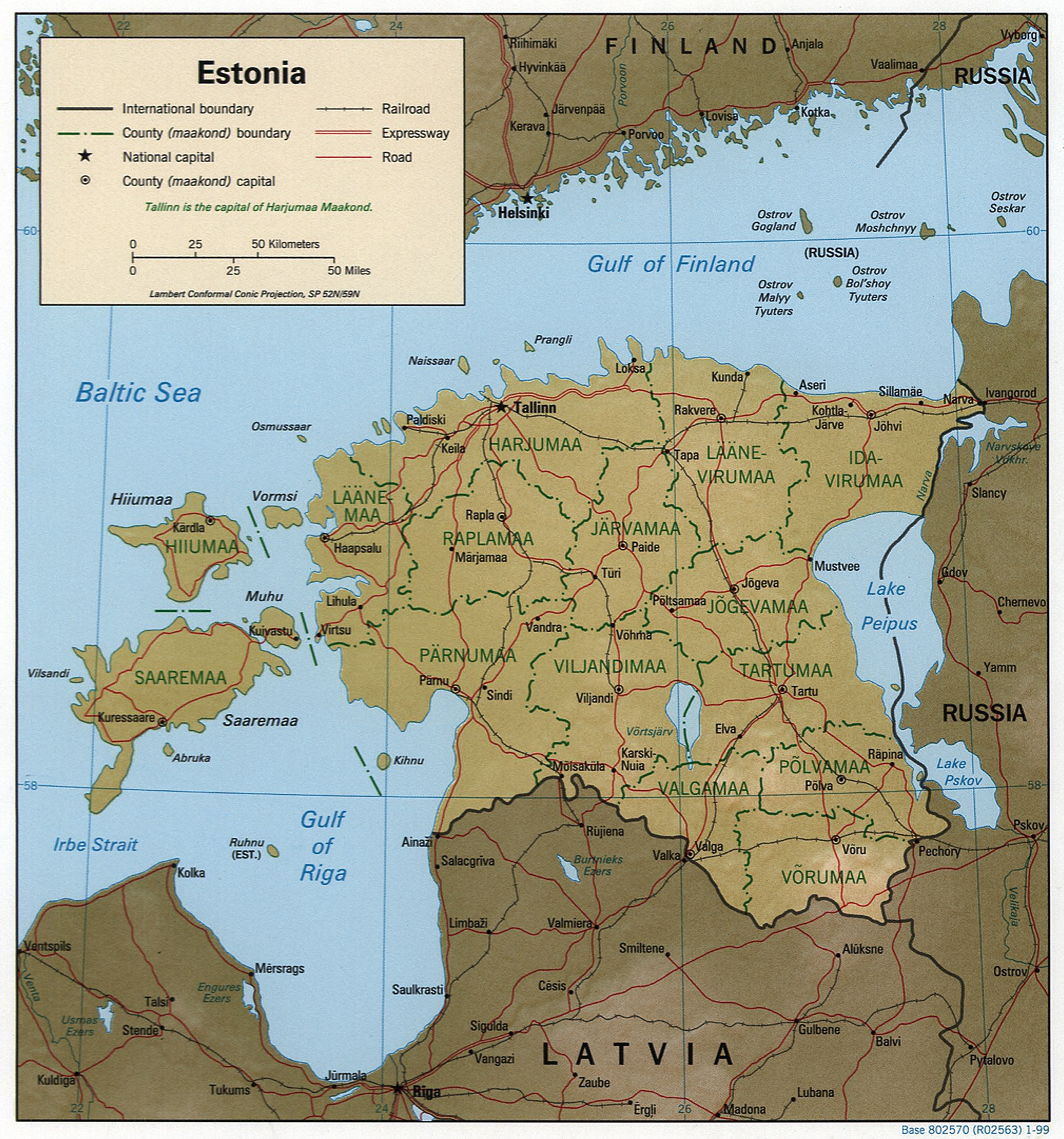
Estonia 1999 CIA Map
Estonia, formally the Republic of Estonia, is a country by the Baltic Sea in Northern Europe, Northern Europe. It is bordered to the north by the Gulf of Finland across from Finland, to the west by the Baltic Sea, sea across from Sweden, to the south by Latvia, and to the east by Lake Peipus and Russia. The territory of Estonia consists of the mainland, the larger islands of Saaremaa and Hiiumaa, and over 2,200 other islands and islets on the eastern coast of the Baltic Sea, covering a total area of . The capital city Tallinn and Tartu are the two List of cities and towns in Estonia, largest urban urban area, areas of the country. The Estonian language is the indigenous language, autochthonous and the official language of Estonia; it is the first language of the majority of its Estonians, population, as well as the world's second most spoken Finnic languages, Finnic Uralic languages, language. The land of what is now modern Estonia has been inhabited by ''Early modern human, ... [...More Info...] [...Related Items...] OR: [Wikipedia] [Google] [Baidu] |
Coastline
The coast, also known as the coastline or seashore, is defined as the area where land meets the ocean, or as a line that forms the boundary between the land and the coastline. The Earth has around of coastline. Coasts are important zones in natural Ecosystem, ecosystems, often home to a wide range of biodiversity. On land, they harbor important ecosystems such as freshwater or estuarine Wetland, wetlands, which are important for bird populations and other terrestrial animals. In wave-protected areas they harbor Salt marsh, saltmarshes, Mangrove, mangroves or Seagrass meadow, seagrasses, all of which can provide nursery habitat for finfish, shellfish, and other aquatic species. Rocky shores are usually found along exposed coasts and provide habitat for a wide range of Sessility (motility), sessile animals (e.g. Mussel, mussels, starfish, Barnacle, barnacles) and various kinds of Seaweed, seaweeds. Along Tropics, tropical coasts with clear, nutrient-poor water, Coral reef, coral ... [...More Info...] [...Related Items...] OR: [Wikipedia] [Google] [Baidu] |
Lake
A lake is an area filled with water, localized in a basin, surrounded by land, and distinct from any river or other outlet that serves to feed or drain the lake. Lakes lie on land and are not part of the ocean, although, like the much larger oceans, they do form part of the Earth's water cycle. Lakes are distinct from lagoons, which are generally coastal parts of the ocean. Lakes are typically larger and deeper than ponds, which also lie on land, though there are no official or scientific definitions. Lakes can be contrasted with rivers or streams, which usually flow in a channel on land. Most lakes are fed and drained by rivers and streams. Natural lakes are generally found in mountainous areas, rift zones, and areas with ongoing glaciation. Other lakes are found in endorheic basins or along the courses of mature rivers, where a river channel has widened into a basin. Some parts of the world have many lakes formed by the chaotic drainage patterns left over from the la ... [...More Info...] [...Related Items...] OR: [Wikipedia] [Google] [Baidu] |
Forest
A forest is an area of land dominated by trees. Hundreds of definitions of forest are used throughout the world, incorporating factors such as tree density, tree height, land use, legal standing, and ecological function. The United Nations' Food and Agriculture Organization (FAO) defines a forest as, "Land spanning more than 0.5 hectares with trees higher than 5 meters and a canopy cover of more than 10 percent, or trees able to reach these thresholds ''in situ''. It does not include land that is predominantly under agricultural or urban use." Using this definition, '' Global Forest Resources Assessment 2020'' (FRA 2020) found that forests covered , or approximately 31 percent of the world's land area in 2020. Forests are the predominant terrestrial ecosystem of Earth, and are found around the globe. More than half of the world's forests are found in only five countries (Brazil, Canada, China, Russia, and the United States). The largest share of forests (45 percent) are in th ... [...More Info...] [...Related Items...] OR: [Wikipedia] [Google] [Baidu] |
Limestone
Limestone ( calcium carbonate ) is a type of carbonate sedimentary rock which is the main source of the material lime. It is composed mostly of the minerals calcite and aragonite, which are different crystal forms of . Limestone forms when these minerals precipitate out of water containing dissolved calcium. This can take place through both biological and nonbiological processes, though biological processes, such as the accumulation of corals and shells in the sea, have likely been more important for the last 540 million years. Limestone often contains fossils which provide scientists with information on ancient environments and on the evolution of life. About 20% to 25% of sedimentary rock is carbonate rock, and most of this is limestone. The remaining carbonate rock is mostly dolomite, a closely related rock, which contains a high percentage of the mineral dolomite, . ''Magnesian limestone'' is an obsolete and poorly-defined term used variously for dolomite, for limes ... [...More Info...] [...Related Items...] OR: [Wikipedia] [Google] [Baidu] |


