|
Geneva Spur
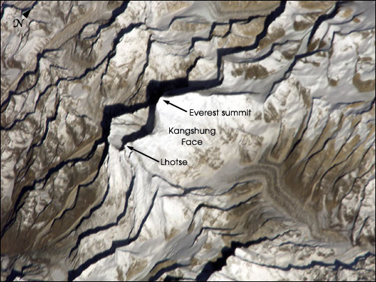
The Geneva Spur, named Eperon des Genevois and has also been called the Saddle Rib "Chapter Two ..Saddle Rib" is a geological feature on Mount Everestit is a large rock buttress near the summits of Everest and Lhotse. The Geneva spur is above Camp III and the Yellow Band, but before Camp IV and South Col. It is a spur near the south col. A related formation is the saddle between the peaks of Mount Everest and Lhotse. The altitude of the spur is between . The Geneva Spur name comes from the 1952 Swiss Mount Everest Expedition. The spur provides a route to the South Col, and is usually traversed by climbers heading for Lhotse or Everest summits. From the top of Geneva Spur, South Col can be seen, and when looking at it Mount Everest is on the left and Lhotse to the right. Lhotse climbers typically head southeast from Geneva Spur, and on to a couloir to ascend that summit. History On the 1956 Swiss Everest–Lhotse Expedition, the spur was the location of the last high camp befo ... [...More Info...] [...Related Items...] OR: [Wikipedia] [Google] [Baidu] |
Mount Everest
Mount Everest (; Tibetan: ''Chomolungma'' ; ) is Earth's highest mountain above sea level, located in the Mahalangur Himal sub-range of the Himalayas. The China–Nepal border runs across its summit point. Its elevation (snow height) of was most recently established in 2020 by the Chinese and Nepali authorities. Mount Everest attracts many climbers, including highly experienced mountaineers. There are two main climbing routes, one approaching the summit from the southeast in Nepal (known as the "standard route") and the other from the north in Tibet. While not posing substantial technical climbing challenges on the standard route, Everest presents dangers such as altitude sickness, weather, and wind, as well as hazards from avalanches and the Khumbu Icefall. , over 300 people have died on Everest, many of whose bodies remain on the mountain. The first recorded efforts to reach Everest's summit were made by British mountaineers. As Nepal did not allow foreigners ... [...More Info...] [...Related Items...] OR: [Wikipedia] [Google] [Baidu] |
Lhotse
Lhotse ( ne, ल्होत्से ; , ''lho tse'', ) is the fourth highest mountain in the world at , after Mount Everest, K2, and Kangchenjunga. The main summit is on the border between Tibet Autonomous Region of China and the Khumbu region of Nepal. With Everest to the north and Nuptse to the west, Lhotse forms the apex of the massive horseshoe-shaped arc of the Everest massif. Despite the tremendous vertical relief of its South and Northeast Faces, it is the least prominent of the eight-thousanders due to the great height of the South Col between it and Everest. Lhotse’s Western Face, recessed behind the head of the Khumbu Glacier in the Western Cwm, plays an integral part in the standard routes of ascent for both peaks; the name Lhotse, which means "South Peak" in Tibetan, further emphasizes the close relationship between the two. The main ridge of the mountain features four distinct summits: Lhotse Main at above sea level, Lhotse Middle (also known as Lhotse Ce ... [...More Info...] [...Related Items...] OR: [Wikipedia] [Google] [Baidu] |
South Col
The South Col is a sharp-edged col between Mount Everest and Lhotse, the highest and fourth-highest mountains in the world, respectively. The South Col is typically swept by high winds, leaving it free of significant snow accumulation. Since 1950 (when Tibet was closed), most Everest expeditions have left from Nepal and gone via the southeast ridge and the South Col (instead of via the North Col). When climbers attempt to climb Everest from the southeast ridge in Nepal, their final camp (usually Camp IV) is situated on the South Col. The South Col was first reached on 12 May 1952 by Aubert, Lambert, and Flory of Edouard Wyss-Dunant's Swiss Mount Everest Expedition that failed to reach the summit. The following year, when Mount Everest was first climbed, Wilfrid Noyce and the Sherpa Annullu were the first climbers on the expedition to reach the col. According to John Hunt, the expedition leader: Once on the South Col, climbers have entered the death zone; altitude sickness ... [...More Info...] [...Related Items...] OR: [Wikipedia] [Google] [Baidu] |
Spur (topography)
A spur is a lateral ridge or tongue of land descending from a hill, mountain or main crest of a ridge. It can also be defined as another hill or mountain range which projects in a lateral direction from a main hill or mountain range. Examples of spurs include: *Abbott Spur, which separates the lower ends of Rutgers Glacier and Allison Glacier on the west side of the Royal Society Range in Victoria Land, Antarctica *Boott Spur, a subpeak of Mount Washington *Kaweah Peaks Ridge, a spur of the Great Western Divide, a sub-range of California's Sierra Nevada *Kelley Spur, east of Spear Spur on the south side of Dufek Massif in the Pensacola Mountains, Antarctica *Geneva Spur on Mount Everest *Sperrin Mountains in Northern Ireland [...More Info...] [...Related Items...] OR: [Wikipedia] [Google] [Baidu] |
Saddle (landform)
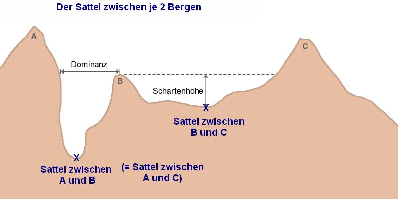
The saddle between two hills or mountains is the region surrounding the saddle point, the lowest point on the line tracing the drainage divide (the col) connecting the peaks. When, and if, the saddle is navigable, even if only on foot, the saddle of a (optimal) pass between the two massifs, is the area generally found around the lowest route on which one could pass between the two summits, which includes that point which is a mathematically when graphed a relative high along one axis, and a relative low in the perpendicular axis, simultaneously; that point being by definition the col of the saddle. Topography A saddle is the lowest area between two highlands (prominences or peaks) which has two wings which span the divide (the line between the two prominences) by crossing the divide at an angle, and, so is concurrently the local highpoint of the land surface which falls off in the lower direction. That is, the drainage divide is a ridge along the high point of the saddle, as ... [...More Info...] [...Related Items...] OR: [Wikipedia] [Google] [Baidu] |
1952 Swiss Mount Everest Expedition
Led by Edouard Wyss-Dunant, the 1952 Swiss Mount Everest expedition saw Raymond Lambert and Sherpa Tenzing Norgay reach a height of about on the southeast ridge, setting a new climbing altitude record, opening up a new route to Mount Everest and paving the way for further successes by other expeditions. Origins Tibet was closed to foreigners but Nepal had just opened up it's borders. In 1951 Eric Shipton's British-New Zealand reconnaissance climbed the Khumbu Icefall and reached the elusive Western Cwm, proving that Everest could be climbed from Nepal. Unfortunately for the British, who had enjoyed exclusive access to the mountain for 31 years from Tibet to the north, the Nepalese government gave the 1952 permit to the Swiss. Organization Edouard Wyss-Dunant was appointed as the leader of this expedition. The other Swiss members were Rene Aubert, Leon Flory, André Roch and Raymond Lambert (despite Lambert's having suffered amputation of frostbitten toes). All the of Swiss exp ... [...More Info...] [...Related Items...] OR: [Wikipedia] [Google] [Baidu] |
Couloir
A ''couloir'' (, "passage" or "corridor") is a narrow gully with a steep gradient in a mountainous terrain.Whittow, John (1984). ''Dictionary of Physical Geography''. London: Penguin, p. 121. . Geology A couloir may be a seam, scar, or fissure, or vertical crevasse in an otherwise solid mountain mass. Though often hemmed in by sheer cliff walls, couloirs may also be less well-defined, and often simply a line of broken talus or scree ascending the mountainside and bordered by trees or other natural features. Couloirs are especially significant in winter months when they may be filled in with snow or ice, and become much more noticeable than in warmer months when most of the snow and ice may recede. These physical features make the use of couloirs popular for both mountaineering and extreme skiing Extreme skiing is performed on long, steep (typically from 45 to 60+ degrees, or grades of 100 to 170 percent) slopes in mountainous terrain. The French coined the term 'Le Ski Ext ... [...More Info...] [...Related Items...] OR: [Wikipedia] [Google] [Baidu] |
Ernst Reiss
Ernst Reiss (24 February 1920, Davos – 3 August 2010, Basel) was a Swiss mountaineer, who together with Fritz Luchsinger was the first to climb the fourth highest mountain on earth in 1956. On 18 May 1956, Reiss and Luchsinger successfully climbed the Lhotse, the fourth highest mountain on earth. Lhotse is connected to Mount Everest via the South Col on the border of Tibet and Nepal. Reiss was a member of the 1956 Swiss Everest–Lhotse expedition. At the end of April and start of May, the expedition erected some high camps. From the last high camp at the "Geneva Spur" on 18 May, Luchsinger and Reiss climbed the summit of Lhotse mountain. Their colleagues Ernst Schmied and Jürg Marmet were successful on 23 May and one day later Dölf Reist and Hansruedi von Gunten made the second and third climb on Mount Everest. Reiss died in Basel, Switzerland, on 3 August 2010, aged 90. [...More Info...] [...Related Items...] OR: [Wikipedia] [Google] [Baidu] |


