|
Gythio
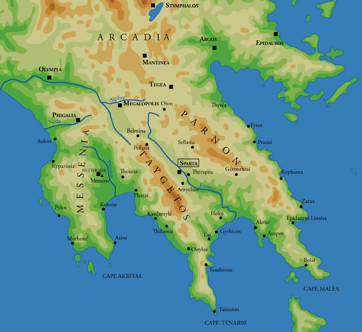
Gytheio ( el, Γύθειο, ) or Gythio, also the ancient Gythium or Gytheion ( grc, Γύθειον), is a town on the eastern shore of the Mani Peninsula, and a former municipality in Laconia, Peloponnese, Greece. Since the 2011 local government reform it is part of the municipality East Mani, of which it is a municipal unit. The municipal unit has an area of 197.313 km2. It was the seaport of Sparta, some north. Gytheio is the site of ancient Cranae, a tiny island where according to legend Paris of Troy and Helen from Sparta spent their first night together before departing for Troy, thus igniting the Trojan War. Gytheio used to be an important port until it was destroyed in 4th century AD, possibly by an earthquake. Even thereafter its strategic location gave Gytheio a significant role in Maniot history. Today it is the largest and most important town in Mani. It is also the seat of the municipality of East Mani. Historical population Geography Gytheio ... [...More Info...] [...Related Items...] OR: [Wikipedia] [Google] [Baidu] |
Cranae
Cranae or Kranai ( el, Κρανάη ) (also Marathonisi) is an island off the coast of Gytheio (ancient Gythium) connected to the land by a causeway built in 1898. Etymology Some believe that the etymology for the name Cranae (Kranai) comes from the legendary king of Athens Kranaos, the successor of King Kekropas (Cecrops) as Athens was also known as "Kranaa". However the word Kranaos according to Homer it has the following meanings: 'Rocky', 'ragged', 'hard'. Therefore, some believe that the word Kranai literally means 'rocky', 'rock'. The name "Marathonisi" translates to 'fennel-island', as the herb fennel was naturally growing on this island. History According to legend, when Paris of Troy abducted Helen from Sparta they spent their first night in Cranae. When Gythium became the major port of ancient Sparta, Cranae became a resting spot for traders. After the rest of Greece enslaved to the Ottoman Turks only Mani remained free. The beys of Mani fortified Cranae with a Ma ... [...More Info...] [...Related Items...] OR: [Wikipedia] [Google] [Baidu] |
Maniots
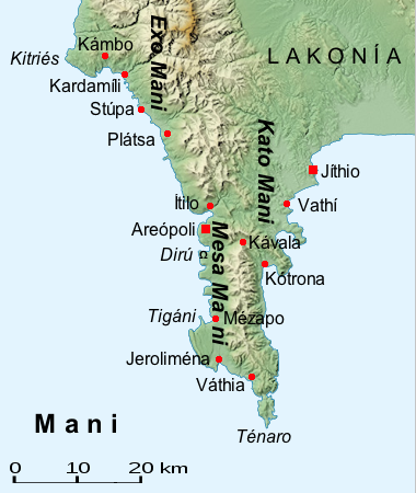
The Maniots or Maniates ( el, Μανιάτες) are the inhabitants of Mani Peninsula, located in western Laconia and eastern Messenia, in the southern Peloponnese, Greece. They were also formerly known as Mainotes and the peninsula as ''Maina''. The Maniots claim to be the descendants of the ancient Spartans and they have often been described as such. The terrain is mountainous and inaccessible (until recently many Mani villages could be accessed only by sea), and the regional name "Mani" is thought to have meant originally "dry" or "barren". The name "Maniot" is a derivative meaning "of Mani". In the early modern period, Maniots had a reputation as fierce and proudly independent warriors, who practiced piracy and fierce blood feuds. For the most part, the Maniots lived in fortified villages (and "house-towers") where they defended their lands against the armies of William II Villehardouin and later against those of the Ottoman Empire. Names The surnames of the Maniots ... [...More Info...] [...Related Items...] OR: [Wikipedia] [Google] [Baidu] |
E4 European Long Distance Path
The E4 European long distance path or E4 path is one of the European long-distance paths. Starting at Tarifa Andalusia, located at the southernmost end of the Iberian Peninsula, across the Strait of Gibraltar facing Morocco, it continues through Spain, France, Switzerland, Germany, Austria, Hungary, Romania, Bulgaria and Greece to end in Cyprus. It also visits the Greek island of Crete. It is more than long, but the route through Romania and part of Bulgaria is not yet completely defined. An alternative route through Serbia, instead of Romania, has been defined. Spain (2267 km) * Andalucia, Murcia and Valencia: From Tarifa, the southernmost point of continental Europe, the E4 follows the GR 7 through Ronda, Alhama de Granada, Moratalla, Alcoi, Elda, Morella. * Catalonia: GR 7 to Bellprat, then GR 172 to Montserrat and finally GR 4 into the Pyrenees. The E4 crosses the border to France east of Andorra. Last city in Spain is Puigcerda. France * Occitania: First city ... [...More Info...] [...Related Items...] OR: [Wikipedia] [Google] [Baidu] |
Mani Peninsula
The Mani Peninsula ( el, Μάνη, Mánē), also long known by its medieval name Maina or Maïna (Μαΐνη), is a geographical and cultural region in Southern Greece that is home to the Maniots (Mανιάτες, ''Maniátes'' in Greek), who claim descent from the ancient Spartans. The capital city of Mani is Areopoli. Mani is the central peninsula of the three which extend southwards from the Peloponnese in southern Greece. To the east is the Laconian Gulf, to the west the Messenian Gulf. The Mani peninsula forms a continuation of the Taygetos mountain range, the western spine of the Peloponnese. Etymology The name "Mani" may come from the albanian word mani meaning mullbery Geography The terrain is mountainous and inaccessible. Until recent years many Mani villages could be reached only by sea. Today a narrow and winding road extends along the west coast from Kalamata to Areopoli, then south to Akrotainaro (the pointed cape, which is the southernmost point of cont ... [...More Info...] [...Related Items...] OR: [Wikipedia] [Google] [Baidu] |
Monastery Of Panayia Yiatrissa
The Monastery of Panagia, Panayia wiktionary:ιατρός#Ancient Greek, Yiatrissa is an Eastern Orthodox Church, Orthodox Christian monastery located in the southern Peloponnese of Greece. The monastery was erected on the site of the ruins of an ancient temple of Athena. The conversion of the temple from pagan to Christian took place possibly as early as 382 AD. The site grew to include many structures spread over a wide area, but sometime later it was largely if not wholly abandoned. Tradition holds that it was reestablished as a Christian monastery in 1683 and that numerous miraculous healings have occurred there. Over the ages, the condition of the monastery has ebbed and flowed with Maniots#Ancient Mani, the tide of wars, occupations, famines, and faltering or flourishing economies. Today, the monastery complex includes a moderately sized, ornately decorated, Byzantine architecture, Byzantine-style church, and a second small but quaint chapel. Residential quarters for over ... [...More Info...] [...Related Items...] OR: [Wikipedia] [Google] [Baidu] |
Mavrovouni, Laconia
Mavrovouni ( Greek: Μαυροβούνι, "the black mountain") is a village (population approximately 500) in the Mani Peninsula, Greece, south of Gytheio town. Geography Mavrovouni is a village about 2 km south of the town of Gytheio, in Laconia, Greece. It is located on a steep hill of dark rock between the hill of Kumaros above Gytheio and the alluvial plain of the Vardhounia river lies a belt of low sandy hills. The district is rich in wines, olives and oranges. The village's economy is based on olive oil production, fishing and tourism. History The hill of Mavrovouni was settled in the early Bronze Age, were Early Helladic ceramics were found here. Waterhouse & Hope-Simpson, pp. 114–118. (with map & plans of the graves) One sherd with a cable pattern is from a pithos of a micaceous fabric found at Mavrovouni. During the Mycenaean period ( LHIII), seven chamber graves were carved into the rock on the slopes below the summit. South of it are remains of a tholos, ... [...More Info...] [...Related Items...] OR: [Wikipedia] [Google] [Baidu] |
Greek National Road 39
Greek National Road 39 ( el, Εθνική Οδός 39, EO39) is a national highway of Greece. It connects Tripoli with Gytheio via Sparti. It is connected with the Greek National Road 7 (Corinth - Kalamata) in Tripoli, with the Moreas Motorway (Corinth - Kalamata) south of Tripoli, with the Greek National Road 82 ( Pylos - Kalamata - Sparti) in Sparti, and with the Greek National Road 86 ( Krokees - Monemvasia Monemvasia ( el, Μονεμβασιά, Μονεμβασία, or ) is a town and municipality in Laconia, Greece. The town is located on a small island off the east coast of the Peloponnese, surrounded by the Myrtoan Sea. The island is connected ...) in Krokees. Until 2016, the EO39 coincided with the European route E961 for most of its length, now it is mainly designated on the A71. Since April 18, 2016, most of the traffic between Sparti and Tripoli is carried by the A71 (Megalopoli - Lefktro - Sparti). References 39 Roads in Peloponnese (region) {{gree ... [...More Info...] [...Related Items...] OR: [Wikipedia] [Google] [Baidu] |
Sparti
Sparta ( el, Σπάρτη ) is a city and municipality in Laconia, Greece. It lies at the site of ancient Sparta. The municipality was merged with six nearby municipalities in 2011, for a total population (as of 2011) of 35,259, of whom 17,408 lived in the city. History Beginning in the 13th century, the political and cultural center of Laconia shifted to Mystras, some 4 km to the west. The settlement at ancient Sparta, named Lacedaemonia, continued to exist, although greatly depopulated, until modern times as a town of a few thousand people who lived among the ruins, in the shadow of Mystras. The Palaiologos family (the last Byzantine Greek imperial dynasty) also lived in Mystras. The Despotate of the Morea was captured by the Ottomans under Mehmed II in 1460. In 1834, after the Greek War of Independence, King Otto of Greece decreed the town should be expanded into a city. Modern day Sparta, the capital of the prefecture of Lakonia, lies on the eastern foothills of Mo ... [...More Info...] [...Related Items...] OR: [Wikipedia] [Google] [Baidu] |


_2.jpg)