|
Guyhirn
Guyhirn (sometimes spelled Guyhirne) is a village near the town of Wisbech in Cambridgeshire, England. It is on the northern bank of the River Nene, at the junction of the A141 with the A47. The population is included in the civil parish of Wisbech St Mary. It is notable chiefly for the Chapel of Ease, a rare example of church architecture of the Interregnum (1649–1660), and as a key crossing point of the River Nene. History According to ''A Dictionary of British Place Names'', Guyhirn, which was 'La Gyerne' in 1275, derives from the Old French 'guie', which means "a guide" (referencing the control of tidal flow or a "salt-water ditch"), with the Old English 'hyrne', which means an "angle or corner of land". According to folklore, recorded in the early nineteenth century, Guyhirn was the site of "a severe engagement between a Saxon King and the abbot of Ely... the legend informs us that 5000 men were brought into the field... it arose from disputes respecting the boun ... [...More Info...] [...Related Items...] OR: [Wikipedia] [Google] [Baidu] |
Guyhirn Chapel Of Ease
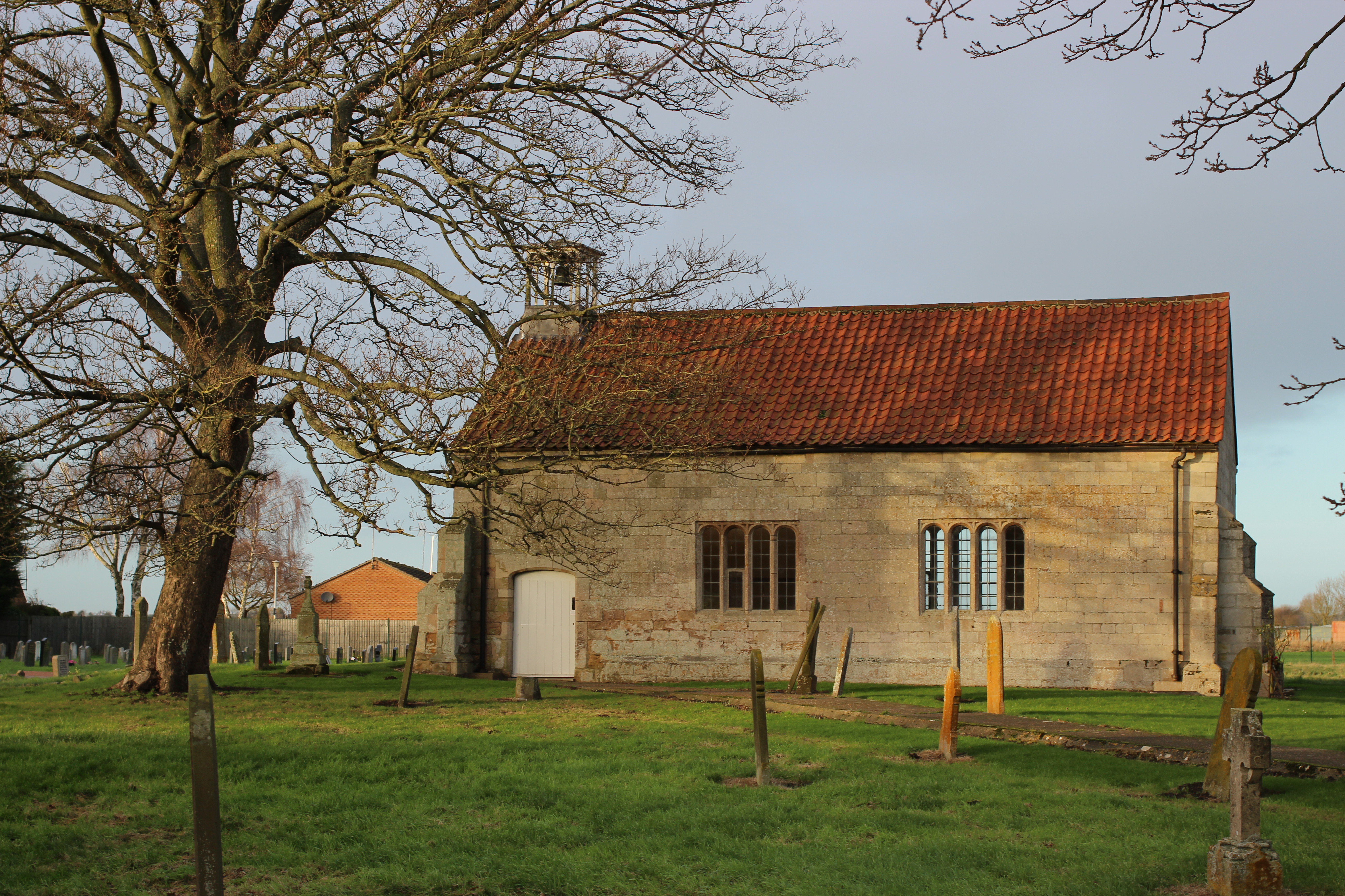
Guyhirn Chapel of Ease, also known as Guyhirn Old Church, is a small rectangular chapel in Guyhirn, Cambridgeshire noted for being built during the Puritan Commonwealth of England. It has survived relatively unchanged since this time, and is a Grade II* listed building under the care of the Churches Conservation Trust. History Money to build the chapel was left in 1651, and the building was thus designed for Puritan worship during the Cromwellian Commonwealth of England. It was built on a site which may have been the location of a medieval chantry (there is evidence of some older stone in the structure). By the 17th century, the land was owned by Thomas Parke of Wisbech, who had Puritan sympathies. After his death in 1630, his land was purchased by Peterhouse, Cambridge, and it is on part of this land that the chapel was built. A stone above the door records the date 1660, by which time the Restoration had returned Anglicanism as the official religious observance. The chapel w ... [...More Info...] [...Related Items...] OR: [Wikipedia] [Google] [Baidu] |
A47 Road
The A47 is a major road in England linking Birmingham to Lowestoft, Suffolk. Most of the section between Birmingham and Nuneaton is now classified as the B4114. From Peterborough eastwards, it is a trunk road (sections west of the A1 road have been downgraded as alternative roads have been built). Details *It is the only A road in Zone 4 to enter Norfolk and Suffolk. No roads from Zones 2, 3, 5, 6, 7, 8 or 9 enter the counties, which lie exclusively in Zone 1. *Between the Clickers Way roundabout in Earl Shilton and the B582 junction near Leicester, the A47 runs through a forest. *Between Birmingham and Nuneaton is the B4114 road. *The A47 road is partly a holiday road, through West Midlands, Warwickshire, Leicestershire, Rutland, Cambridgeshire, Norfolk, and Suffolk, since it ends in Lowestoft, a tourist destination with a beach. On the way it passes the city of Norwich and the Norfolk Broads, both popular tourist destinations in their own right. Its other main function is ... [...More Info...] [...Related Items...] OR: [Wikipedia] [Google] [Baidu] |
Guyhirne Railway Station
Guyhirne railway station was a station at Ring's End, near Guyhirn, Cambridgeshire on the Great Northern and Great Eastern Joint Railway between Spalding and March. It was opened originally by the GNR in 1867. An auction took place in 1867 of items linked to the construction of the railway. It was closed to passengers by the British Transport Commission The British Transport Commission (BTC) was created by Clement Attlee's post-war Labour government as a part of its nationalisation programme, to oversee railways, canals and road freight transport in Great Britain (Northern Ireland had the se ..., due to low usage, in 1953. Goods traffic continued at the station until 1964, whilst the line passing through it remained open until November 1982. Brooksbank, Ben; ''Geograph ... [...More Info...] [...Related Items...] OR: [Wikipedia] [Google] [Baidu] |
Ring's End
Ring's End is a hamlet near Guyhirn in the Isle of Ely in Cambridgeshire, England. The population is included in the civil parish of Elm in the district of Fenland. History Land surrounding Elm including Coldham suffered serious flooding, with loss of human life, stock and crops ruined. As a result Elm and district became "greatly impoverished and likely to be overthrown". Attempts to improve the situation took place and the "Little Bill" of 1607 involving 6,000 acres known as "The Ring of Waldersea and Coldham" involving a system of drainage ditches forming a rough circle led to an improvement in the area. This "ring" is commemorated in the name Ring's End, a hamlet near Guyhirn. Ring's End School was built in 1860 as a school and mission hall. The class rooms were on the upper floor. It was enlarged in 1894-5 and again in 1905. The school was closed in 1949. In 1889 the 'lock-up'was rented out by Wisbech council. As a consequence of a bridge being built across the river Nen ... [...More Info...] [...Related Items...] OR: [Wikipedia] [Google] [Baidu] |
River Nene
The River Nene ( or : see below) is a river in the east of England that rises from three sources in Northamptonshire.OS Explorer Map sheet 223, Northampton & Market Harborough, Brixworth & Pitsford Water. The river is about long, about of which forms the border between Cambridgeshire and Norfolk. It is the tenth-longest river in the United Kingdom, and is navigable for , from Northampton to The Wash. Etymology and pronunciation Spelling of the river's name has altered over time; it was called the "Nenn" or "Nyn" in an 1810 engraving by draughtsmen George Cole and John Roper, while the Ordnance Survey of 1885 used what has since become standard spelling, "Nene". The origin and meaning of the River Nene's name is unknown. The earliest known examples, which date back to the 10th century AD, have been linked to Indo-European root words for snow, rain, or washing, but a direct connection is purely speculative. According to the British toponymist and medieval scholar Victor Watt ... [...More Info...] [...Related Items...] OR: [Wikipedia] [Google] [Baidu] |
A141 Road
List of A roads in zone 1 in Great Britain beginning north of the River Thames The River Thames ( ), known alternatively in parts as the River Isis, is a river that flows through southern England including London. At , it is the longest river entirely in England and the second-longest in the United Kingdom, after the ..., east of the A1 (roads beginning with 1). Single- and double-digit roads Triple-digit roads Four-digit roads 1000s 1100s 1200s and higher References {{DEFAULTSORT:A Roads in Zone 1 of the Great Britain Numbering Scheme 1 1 1 ... [...More Info...] [...Related Items...] OR: [Wikipedia] [Google] [Baidu] |
Wisbech St Mary
Wisbech St Mary is a village in the Fenland District of Cambridgeshire, England. It is west of the town of Wisbech. It lies between two roads, the B1169 and the A47. The population of the civil parish (including Guyhirn and Thorney Toll) at the 2011 Census was 3,556. History In the later Middle Ages various subordinate manors were located in the parish including Hiptofts, Jacketts, Tuddenham Hall and Bevis Hall. About 1400 Edward and John Hiptoft had a licence for an oratory in their house on or near the site of Hiptoft Farm, about a mile east of Murrow and a mile west of St Mary's village. In 1476 Isabel, wife of Sir William Norreys and widow of John Nevile, Marquess of Montagu, held 100 shillings rents of assize in Wisbech, known as 'Hiptofts rent'. The manor of Hiptofts was settled in 1525–6 by Christopher Coote and Elizabeth his wife on John Huddleston and others, together with the fishery and 40 shillings rent in Wisbech and Leverington. By 1620 it was held by Humphrey ... [...More Info...] [...Related Items...] OR: [Wikipedia] [Google] [Baidu] |
Great Northern And Great Eastern Joint Railway
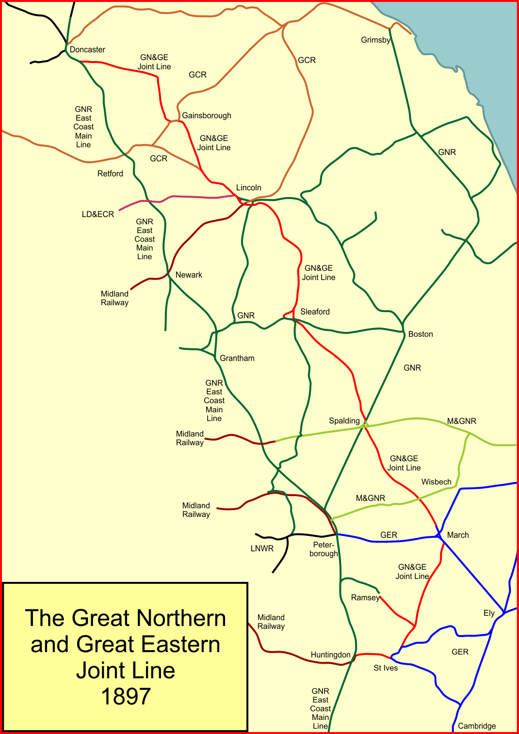
The Great Northern and Great Eastern Joint Railway, colloquially referred to as "the Joint Line"''Joint Line Joy'', in the Railway Magazine, June 2015 was a railway line connecting Doncaster and Lincoln with March and Huntingdon in the eastern counties of England. It was owned jointly by the Great Northern Railway (GNR) and the Great Eastern Railway (GER). It was formed by transferring certain route sections from the parent companies, and by the construction of a new route between Spalding and Lincoln, and a number of short spurs and connections. It was controlled by a Joint Committee, and the owning companies operated their own trains with their own rolling stock. The Joint Line amounted to nearly of route. The motivation for its formation was chiefly the desire of the GER to get direct access to the coalfields of South Yorkshire and elsewhere, and the wish of the GNR to discourage more ambitious incursion by the GER into its own territory, as well as the provision of relief ... [...More Info...] [...Related Items...] OR: [Wikipedia] [Google] [Baidu] |
Wisbech
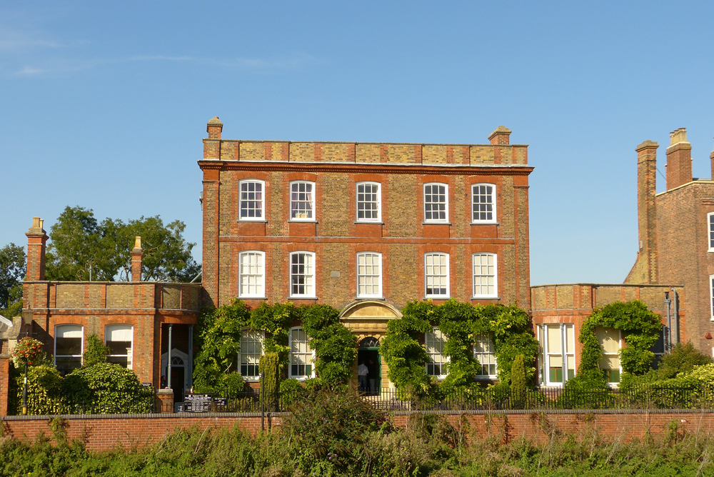
Wisbech ( ) is a market town, inland port and civil parish in the Fenland district in Cambridgeshire, England. In 2011 it had a population of 31,573. The town lies in the far north-east of Cambridgeshire, bordering Norfolk and only 5 miles (8 km) south of Lincolnshire. The tidal River Nene running through the town is spanned by two road bridges. Wisbech is in the Isle of Ely (a former administrative county) and has been described as 'the Capital of The Fens". Wisbech is noteworthy for its fine examples of Georgian architecture, particularly the parade of houses along the North Brink, which includes the National Trust property of Peckover House and the circus surrounding Wisbech Castle. History Etymology The place name 'Wisbech' is first attested in the '' Anglo-Saxon Chronicle'' for the year 656, where it appears as ''Wisbeach''. It is recorded in the 1086 Domesday Book as ''Wisbeach''. The name Wisbech is popularly believed to mean "on the back of the (River ... [...More Info...] [...Related Items...] OR: [Wikipedia] [Google] [Baidu] |
Tiddy Mun
Tiddy Mun was a legendary bog spirit in England, who was believed to have the ability to control the waters and mists of The Fens of South Lincolnshire, The Carrs of North Lincolnshire and fens of the Isle of Ely. Legend The belief in Tiddy Mun was first documented in June 1891 in an article by M. C. Balfour in the Folklore Society journal ''Folk-Lore''. In the article she recalls a story, collected in the Ancholme Valley, told to her by an older person who spoke of a curse of pestilence that had been cast upon his village by the Tiddy Mun, who was angered at the draining of the Fens by the Dutch, led by Cornelius Vermuyden, in the seventeenth century. According to the story the Tiddy Mun was eventually placated after the villagers gathered at twilight at the time of the new moon, poured buckets of water into the dyke and apologised for the damage caused. He was not exclusively malevolent; if the Fens flooded and the waters reached the villages, people would go out at night and c ... [...More Info...] [...Related Items...] OR: [Wikipedia] [Google] [Baidu] |
John Morton (bishop)
John Morton ( – 15 September 1500) was an English cleric, civil lawyer and administrator during the period of the Wars of the Roses. He entered royal service under Henry VI and was a trusted councillor under Edward IV and Henry VII. Edward IV made him Bishop of Ely and under Henry VII he became Lord Chancellor, Archbishop of Canterbury and a cardinal. Early life Morton was born in around 1420 either in Milborne St Andrew or Bere Regis in Dorset. He came from the minor gentry of the time: his father was Richard Morton of Milborne St Andrew and his uncle, William Morton of Cerne, represented Shaftesbury in Parliament in 1437. Morton was educated at the University of Oxford, becoming a Bachelor of Civil Law in 1448, a Bachelor of Civil and Canon Law in 1451 and a Doctor of Civil Law in 1452. He practised as a proctor in the chancellor’s court at Oxford from 1448 and in 1451 he was acting as a commissary or deputy and official of the chancellor of the university. In 1452 ... [...More Info...] [...Related Items...] OR: [Wikipedia] [Google] [Baidu] |
Isle Of Ely County Council
Isle of Ely County Council was the county council of Isle of Ely in the east of England. It came into its powers on 1 April 1889 and was abolished on 1 April 1965. The county council was based at County Hall, March. It was amalgamated with Cambridgeshire County Council to form the new Cambridgeshire and Isle of Ely County Council in 1965. The Isle of Ely County Council was granted a coat of arms A coat of arms is a heraldic visual design on an escutcheon (i.e., shield), surcoat, or tabard (the latter two being outer garments). The coat of arms on an escutcheon forms the central element of the full heraldic achievement, which in its ... on 1 May 1931. Previous to the grant the council had been using the arms of Diocese of Ely: ''Gules, three ducal coronets, two and one or''. In the 1931 grant, silver and blue waves were added to the episcopal arms, to suggest that the county was an "isle". The crest above the shield was a human hand grasping a trident around which an eel ... [...More Info...] [...Related Items...] OR: [Wikipedia] [Google] [Baidu] |


