|
Guiltcross Rural District
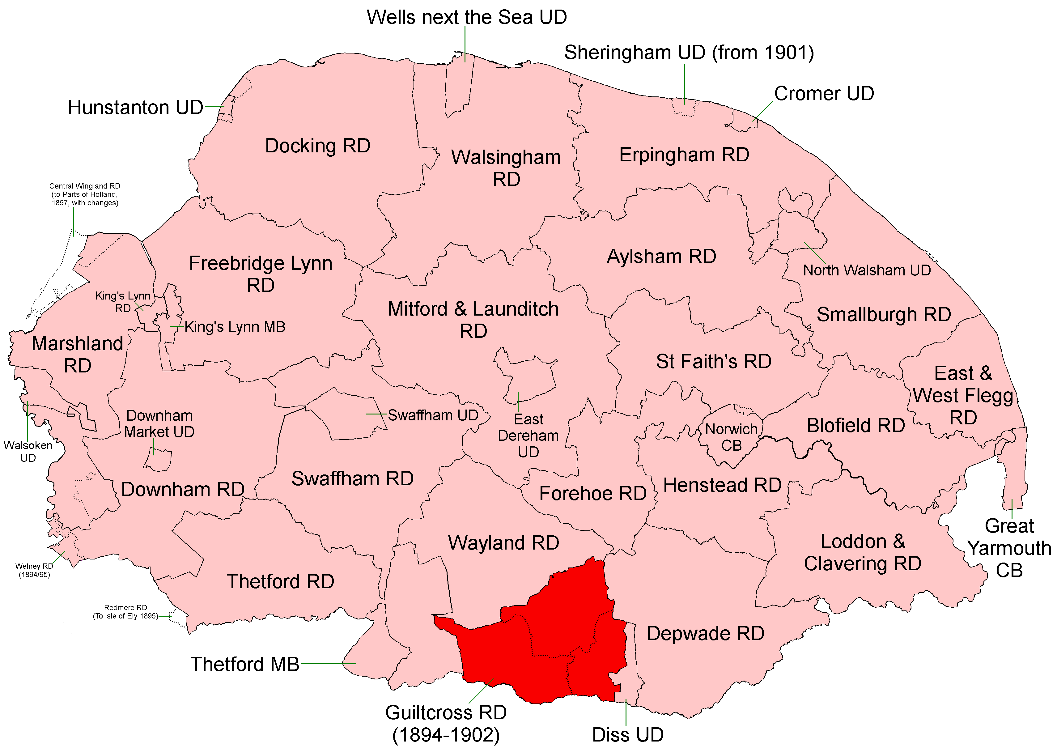
Guiltcross Rural District was a rural district in Norfolk, England from 1894 to 1902. It was formed under the Local Government Act 1894 based on the Guiltcross rural sanitary district. It lay in the southern part of the county between Thetford and Diss and took its name from the ancient Guiltcross hundred. In 1902, Guiltcross RD was abolished and its territory divided between Thetford, Wayland and Depwade Depwade Rural District was a rural district in Norfolk, England from 1894 to 1974. It was formed under the Local Government Act 1894 based on the Depwade rural sanitary district, taking its name from the ancient Depwade hundred. It lay to the e ... RDs. Parishes & Statistics Population figures from 1901 census via Vision of Britain. References {{coord, 52.43, 0.99, type:adm3rd_dim:25000_region:GB-NFK, display=title Districts of England created by the Local Government Act 1894 Historical districts of Norfolk Rural districts of England ... [...More Info...] [...Related Items...] OR: [Wikipedia] [Google] [Baidu] |
Fersfield
Fersfield is a village and former civil parish, now in the parish of Bressingham, in the South Norfolk district, in the county of Norfolk, England. It was the home parish of Francis Blomefield, whose ''History of Norfolk'' documents the history of much of South Norfolk. In 1931 the parish had a population of 194. On 1 April 1935 the parish was abolished and merged with Bressingham. Location Fersfield is bounded on the east and south by the village of Bressingham; to the west are South Lopham and North Lopham and to the north Kenninghall. Historically, the parish marked the boundary of the hundred of Diss. Name Fersfield has been variously recorded as Fersevella, Fervessella, Ferefeud, Fairfeud, Fairvill, and Fersfell, all of which seemed to Blomefield to signify a Fair Fee, or Village. However, modern research suggests the more obvious etymology of 'a furze-covered field. The village was recorded in the Domesday Book of 1086 under Fersfield. Church The church is dedi ... [...More Info...] [...Related Items...] OR: [Wikipedia] [Google] [Baidu] |
Wilby, Norfolk
Wilby is a village and former civil parish, south west of Norwich, now in the parish of Quidenham, in the Breckland district, in the county of Norfolk, England. In 1931 the parish had a population of 94. Wilby has a church called All Saints. History The name "Wilby" means 'Willow-tree farm/settlement' or 'willow-tree circle'. There are earthworks of Wilby deserted medieval village and there is evidence of Saxon occupation. Wilby was recorded in the Domesday Book Domesday Book () – the Middle English spelling of "Doomsday Book" – is a manuscript record of the "Great Survey" of much of England and parts of Wales completed in 1086 by order of King William I, known as William the Conqueror. The manus ... as ''Wilebey''/''Wilgeby''/''Willebeih''. On 1 April 1935 the parish was abolished and merged with Quidenham. References Villages in Norfolk Former civil parishes in Norfolk Quidenham {{Norfolk-geo-stub ... [...More Info...] [...Related Items...] OR: [Wikipedia] [Google] [Baidu] |
Harling, Norfolk
Harling is a civil parish in the English county of Norfolk. It covers an area of and had a population of 2,201 in 932 households at the 2001 census, . Office for National Statistics & Norfolk County Council (2001). Retrieved 20 June 2009 reducing to a population of 2,142 in 941 households at the 2011 census. For the purposes of local government, it falls within the of Breckland. The principal set ... [...More Info...] [...Related Items...] OR: [Wikipedia] [Google] [Baidu] |
South Lopham
South Lopham is a village and civil parish in the English county of Norfolk. It covers an area of and had a population of 371 in 157 households at the 2001 census. For the purposes of local government, it falls within the district of Breckland. History In the 1950s evidence for occupation of the area dating back to Neolithic and Bronze age times was found in the locality in the form of a Neolithic polished flint axe head and a quartzite stone axe hammer (Neolithic or Bronze age). The settlement is first recorded in the Domesday Book of 1086 as Lopham, held by Roger Bigod, later becoming known as Lopham Parva to mirror the existing village of Lopham Magna (now North Lopham), and then finally becoming known by its present name of ''South Lopham''. The name Lopham originates from the Old English for 'Loppa's homestead'. The manor house in the vicinity of the two Lophams was held by the Bigod lords until 1302 when the land was surrendered to the crown. In 1310 King Edward I ... [...More Info...] [...Related Items...] OR: [Wikipedia] [Google] [Baidu] |
Shelfanger
Shelfanger is a village situated about 3 miles from the town of Diss in Norfolk, England. There is a church and a village hall in the village. It covers an area of and had a population of 362 in 150 households at the 2001 census, the population increasing to 378 at the 2011 census. In years gone by there was a school, a post office, a pub, three shops, a blacksmiths and a garage run by a family of brothers called Bowman. These have all now been closed down. Josh Kirby Ronald William "Josh" Kirby (27 November 1928 – 23 October 2001) was a British commercial artist. Over a career spanning 60 years, he was the artist for the covers of many science fiction books including Terry Pratchett's Discworld novels. ... (died 2001), an artist lived there. History The villages name means 'Shelf wood'. This village has been previously recorded as ''Scelvangra'', ''Schelfangyll'', ''Shelfangles'', ''Shelfhangre'' and ''Shelfhanger'', though the significance of its name is large ... [...More Info...] [...Related Items...] OR: [Wikipedia] [Google] [Baidu] |
Roydon, South Norfolk
Roydon is a small village, parish and electoral ward in the county of Norfolk, England, about a mile west of Diss. It covers an area of and had a population of 2,358 in 981 households at the 2001 census, the population of both parish and ward increasing to 2,457 at the 2011 Census. It is mentioned in 1035 as ''Rygedune'', and as ''Regadona'' and ''Regheduna'' in the Domesday Book, and later in 1242 as ''Reydon''. In 1603 there were 124 communicants, and in 1736 there were 60 families, totalling 240 souls. In 1736 it was assessed for tax at 630 and a half pounds. Roydon's current village hall was built in 1988 on the site of a previous building. The exterior wall hosts a relief carving relocated from Aldrich Brothers brush factory, in Factory Lane, which was demolished in 1972 It also has a small village primary school, Roydon Primary that teaches 200 pupils from 4 to 11, Reception to Year 6 (Kindergarten to 5th Grade). Its church, St Remigius, is one of 124 existing rou ... [...More Info...] [...Related Items...] OR: [Wikipedia] [Google] [Baidu] |
Riddlesworth
Riddlesworth is a civil parish in the English county of Norfolk. It covers an area of and had a population of 147 in 48 households at the 2001 census. For the purposes of local government, it falls within the district of Breckland. St Peter's Church Situated just beyond Riddlesworth Hall and school, St Peter's has an early 14th-century west tower and the plain octagonal font is 15th century.There is a fine monument to Sir Drue Drury (died 1617) of a kneeling knight with angels holding back curtains. The floor slabs at the end of the east end of the nave tell the sad tale of two ladies who were killed in their beds at the hall when a chimney stack fell on them in the 'furious hurricane' of 1703. Riddlesworth Hall It is home to the Riddlesworth Hall, a listed Grade II former country house, built in 1792 and subsequently reconverted into a private preparatory school, where Diana, Princess of Wales was a pupil. Set in large grounds, the school was acquired by the Confuci ... [...More Info...] [...Related Items...] OR: [Wikipedia] [Google] [Baidu] |
Quidenham
Quidenham is a small rural village and civil parish in the English county of Norfolk. It covers an area of and had a population of 576 in 183 households at the 2001 census,Census population and household counts for unparished urban areas and all parishes Office for National Statistics & Norfolk County Council (2001). Retrieved 20 June 2009. falling to a population of 560 living in 189 households at the 2011 Census. For the purposes of local government, it falls within the of [...More Info...] [...Related Items...] OR: [Wikipedia] [Google] [Baidu] |
Old Buckenham
Old Buckenham is a village and civil parish in the English county of Norfolk, approximately south-west of Norwich. It covers an area of and had a population of 1,294 in 658 households at the 2001 census falling to a population of 1,270 living in 529 households at the census 2011. For the purposes of local government, it falls within the district of Breckland. History Toponymy Old Buckenham was listed as ''Bucham'', ''Buccham'' or ''Bucheham'' in the 1068 Domesday Book. The name comes from the Old English for "homestead of a man called Bucca". Nineteenth century During the nineteenth century there was a small Sandemanian community in the village which the natural philosopher Michael Faraday visited many times in the 1850s and 1860s. Governance Since 2015, Old Buckenham is in The Buckenhams & Banham ward of Breckland district, which returns one councillor to the district council. Since 2010, the parish is part of the Parliamentary constituency of Mid Norfolk. Historicall ... [...More Info...] [...Related Items...] OR: [Wikipedia] [Google] [Baidu] |
North Lopham
North Lopham is a village and civil parish in the English county of Norfolk. It covers an area of and had a population of 623 in 255 households at the 2011 census. For the purposes of local government, it falls within the district of Breckland. The church of St. Nicholas is situated within North Lopham, along Church Lane. St. Nicholas's church was described in 1870 as: "The church was built by W. Bigod; has a Norman porch; exhibits, on the exterior and round the buttresses, many Latin inscriptions." History North Lopham was first mentioned in the ''Little Doomsday Book'' of 1086 and was referred to as 'Lopham Alia'. This Latin name can be translated into 'Another Lopham'. The name Lopham originates from the Old English for 'Loppa's homestead'. The earliest known building within the parish was a Roman villa located in the East of the village. This was discovered through Roman materials, such as pottery, and coins being found as a result of ploughing and metal detecting. Dur ... [...More Info...] [...Related Items...] OR: [Wikipedia] [Google] [Baidu] |
New Buckenham
New Buckenham is a village and civil parish in the English county of Norfolk. The parish covers an area of and had a population of 468 in 197 households at the 2001 census, falling marginally to a population of 460 in 209 households at the 2011 census. The small parish includes only the village, New Buckenham Common and some outlying houses and farmland. It is in the local government district of Breckland. A nucleated village, New Buckenham has a medieval grid plan encompassing a green that originally served as the market place. At the green there is a historic market house, a grade II-star listed building which features a whipping post, and commonly called the Market Cross. The village entirely comprises a conservation area together with the adjacent Buckenham Castle, which lies in the neighbouring parish of Old Buckenham. Geography The B1113 road passes through the village, diagonally over the green, and then across the Common. This road runs to the city of Norwich, dist ... [...More Info...] [...Related Items...] OR: [Wikipedia] [Google] [Baidu] |


