|
Great Lake, Tasmania
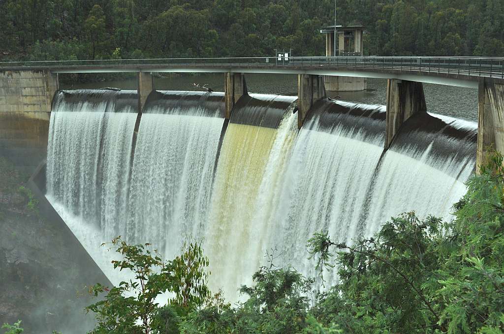
The Great Lake, officially yingina / Great Lake, is a natural lake and man-made reservoir that is located in the central northern region of Tasmania, Australia. Location and features Fed by the Pine Rivulet and Breton Rivulet, the original natural freshwater lake, much smaller in size than its current surface area, was expanded as a result of the 1922 construction of Miena Dam #2 at its southern outflow into the Shannon River. This dam is considered to be of high heritage value by Engineers Australia. Miena Dam #2 created the once-famous ''Shannon Rise'', in the 500-metre section of the Shannon River between the dam and Shannon Lagoon. The hatching of thousands of caddis moths in early summer, attracted large numbers of trout and fishermen. In 1967, a sloping-core rock-fill dam was built just downstream of Miena Dam #2 to increase the maximum-capacity level, destroying the ''Shannon Rise''. It was raised a further in 1982, causing Miena Dam #2 to be periodically submerg ... [...More Info...] [...Related Items...] OR: [Wikipedia] [Google] [Baidu] |
Central Highlands (Tasmania)
The Central Highlands is a region in Tasmania, Australia where geographical and administrative boundaries closely coincide. It is also known as ''The Lake Country of Tasmania''. Geographical region The mountains of Central Tasmania are mainly found in four different conservation reserves: * Cradle Mountain-Lake St Clair National Park - in the western part * Walls of Jerusalem National Park - in the central part * Central Plateau Conservation Area in the eastern part Administrative region The Central Highlands Council incorporates most of the highland region. Former Hydro communities Early power developments by Hydro Tasmania in the Central Highlands included the communities of workers who were employed in construction. Significant numbers of the communities were migrants to Australia The Tarraleah Power Station, Tarraleah community was one established in 1934 which was a significant early community for the Upper Derwent Power Development. The part of Tarraleah known as ... [...More Info...] [...Related Items...] OR: [Wikipedia] [Google] [Baidu] |
Australian National Committee On Large Dams
The Australian National Committee on Large Dams (abbreviated as ANCOLD) is an Australian-based non-government, non-profit and voluntary association of organisations and individual professionals with a common technical interest in large dam A dam is a barrier that stops or restricts the flow of surface water or underground streams. Reservoirs created by dams not only suppress floods but also provide water for activities such as irrigation, human consumption, industrial use, aqua ...s and their environs. ANCOLD is not an advocate for dams but an apolitical industry body that focuses on disseminating knowledge, developing capability and providing guidance on all aspects of dam engineering, management and associated issues. ANCOLD is a member of the International Commission on Large Dams (or ICOLD). Role and functions ANCOLD maintains a register of large dams in Australia, of which approximately 490 dams were listed on the register in 1999. By international convention, "large ... [...More Info...] [...Related Items...] OR: [Wikipedia] [Google] [Baidu] |
List Of Reservoirs And Dams In Australia
Dams and reservoirs in Australia is a link page for any dam or reservoir (water), reservoir in Australia. Australian Capital Territory There are three key water storage facilities located in the Australian Capital Territory. The fourth source of water for Canberra, Googong Dam, is in NSW. In addition, there are four smaller man-made reservoirs used for recreation and as traps for sediment and fertilizers . New South Wales There are dams, weirs, catchments, and barrages in New South Wales. Of these, 135 facilities are considered major dams according to the Australian National Committee on Large Dams. Dams and reservoirs The largest reservoir in New South Wales is the Lake Eucumbene in the Snowy Mountains, formed by the Eucumbene Dam. Weirs and barrages Cancelled and decommissioned Northern Territory There are 805 named water storage facilities located in the Northern Territory. Of these, four facilities are considered major dams according to the Australian Nation ... [...More Info...] [...Related Items...] OR: [Wikipedia] [Google] [Baidu] |
List Of Lakes In Australia
Natural freshwater lakes in Australia are rare due to the general absence of Glacier, glacial and Plate tectonics, tectonic activity in Australia. Types Most lakes in Australia fall within one of five categories. Excluding lakes and lagoons created by List of reservoirs and dams in Australia, man-made dams for water storage and other purposes, one can identify the following: * coastal lakes and lagoons including perched lakes; * natural freshwater inland lakes, often ephemeral and some part of wetland or swamp areas; * the Main Range (Snowy Mountains), Main Range containing mainland Australia's five glacial lakes. In Tasmania, due to glaciation, there are a large number of natural freshwater lakes on the central plateau, many of which have been enlarged or modified by hydro-electric developments; * predominantly dry, salt lake (geography), salt lakes in the flat desert regions of the country lacking organised drainage; and * lakes created in volcanic remnants. List of lakes ... [...More Info...] [...Related Items...] OR: [Wikipedia] [Google] [Baidu] |
Lake Highway
The Lake Highway, or A5, is a main highway and A-road in Tasmania. Although still known as the Lake Highway the official title of the road was changed in 2001 to Highland Lakes Road. The Lake Highway branches off the Midland Highway at Melton Mowbray in southern Tasmania and continues for 152 kilometres, with Bothwell being the main town of any size en route, terminating in Deloraine. Until recently it was the only major A-road in Australia that was partially unsealed; works to seal the road were completed in April 2019. The highway is one of the least used in Tasmania, except during the summer months when the road is used by Great Lake commuters. The portion of the highway on and near the Great Lake in Tasmania's Central plateau, averages a height of about 1000 metres. During the winter months it is sometimes snowed under. Two major roads that branch from the Lake Highway are the Marlborough Highway (which connects to the A10 Lyell Highway), and Poatina Road (B51), which ... [...More Info...] [...Related Items...] OR: [Wikipedia] [Google] [Baidu] |
Shack
A shack (or, in some areas, shanty) is a type of small shelter or dwelling, often primitive or rudimentary in design and construction. Unlike huts, shacks are constructed by hand using available materials; however, whereas huts are usually rural and made of natural materials (mud, rocks, sticks, etc.) shacks are generally composed of scavenged man-made materials like abandoned construction debris, repurposed consumer waste and other useful discarded objects that can be quickly acquired at little or no cost and fashioned into a small dwelling. Background In areas of high population density and high poverty, shacks are often the most prevalent form of housing; it is possible that up to a billion people worldwide live in shacks. Fire is a significant hazard in tight-knit shack settlements. Settlements composed mostly or entirely of shacks are known as slums or shanty towns. In Australian English, ''shack'' can also refer to a small holiday house with limited conveniences, ... [...More Info...] [...Related Items...] OR: [Wikipedia] [Google] [Baidu] |
Hydro Tasmania
Hydro Tasmania, formerly the Hydro-Electric Commission (HEC), is a Tasmanian Government business enterprise which is the main electricity generator in Tasmania, Australia. Originally oriented towards hydro-electricity, owing to Tasmania's dramatic topography and relatively high rainfall in the central and western parts of the state, today Hydro Tasmania operates 30 hydro-electric and one gas power station, and is a joint owner in three wind farms. History Establishment In 1914, the Government of Tasmania set up the Hydro-Electric Department (renamed the Hydro-Electric Commission in 1929) to complete the first hydro-electric power station, the Waddamana Hydro-Electric Power Station. Prior to that two private hydro-electric stations had been opened the Launceston City Council's Duck Reach Power Station, opened 1895 on the South Esk River (it was one of the first hydro-electric power stations in the southern hemisphere. Reefton Power Station in New Zealand is the first m ... [...More Info...] [...Related Items...] OR: [Wikipedia] [Google] [Baidu] |
Poatina Power Station
The Poatina Power Station is a conventional hydroelectric power station located in the Central Highlands, Tasmania, Australia. The power station is situated on the Great Lake and South Esk and is owned and operated by Hydro Tasmania. Technical details Located in the Great Lake and South Esk catchment area, Poatina makes use of a descent from the Great Western Tiers to the Norfolk Plains in Tasmania's northern Midlands. Water from Great Lake is diverted via a tunnel to the edge of the Great Western Tiers where it plummets down a viable penstock line, which enters the ground again near the power station. The Poatina Power Station is located underground in a massive artificial cavern hence the name Poatina, Palawa for "cavern" or "cave". The headrace tunnel and penstocks were bored through mudstone with the aid of a Robbins Mole. Water leaves the power station via a roughly long tailrace tunnel and discharges into the Macquarie River via Brumbies Rivulet. Poatina was comm ... [...More Info...] [...Related Items...] OR: [Wikipedia] [Google] [Baidu] |
Tourism
Tourism is travel for pleasure, and the Commerce, commercial activity of providing and supporting such travel. World Tourism Organization, UN Tourism defines tourism more generally, in terms which go "beyond the common perception of tourism as being limited to holiday activity only", as people "travelling to and staying in places outside their usual environment for not more than one consecutive year for leisure and not less than 24 hours, business and other purposes". Tourism can be Domestic tourism, domestic (within the traveller's own country) or International tourism, international. International tourism has both incoming and outgoing implications on a country's balance of payments. Between the second half of 2008 and the end of 2009, tourism numbers declined due to a severe Economy, economic slowdown (see Great Recession) and the outbreak of the 2009 2009 flu pandemic, H1N1 influenza virus. These numbers, however, recovered until the COVID-19 pandemic put an abrupt end to th ... [...More Info...] [...Related Items...] OR: [Wikipedia] [Google] [Baidu] |
Fishing
Fishing is the activity of trying to catch fish. Fish are often caught as wildlife from the natural environment (Freshwater ecosystem, freshwater or Marine ecosystem, marine), but may also be caught from Fish stocking, stocked Body of water, bodies of water such as Fish pond, ponds, canals, park wetlands and reservoirs. Fishing techniques include trawling, Longline fishing, longlining, jigging, Fishing techniques#Hand-gathering, hand-gathering, Spearfishing, spearing, Fishing net, netting, angling, Bowfishing, shooting and Fish trap, trapping, as well as Destructive fishing practices, more destructive and often Illegal, unreported and unregulated fishing, illegal techniques such as Electrofishing, electrocution, Blast fishing, blasting and Cyanide fishing, poisoning. The term fishing broadly includes catching aquatic animals other than fish, such as crustaceans (shrimp/lobsters/crabs), shellfish, cephalopods (octopus/squid) and echinoderms (starfish/sea urchins). The term is n ... [...More Info...] [...Related Items...] OR: [Wikipedia] [Google] [Baidu] |
Australian Height Datum
The Australian Height Datum was introduced in 1971 as the official vertical datum for Australia, and thereby serves as the Benchmark (surveying), benchmark to which all height measurements are referred. The Australian Height Datum is an amalgamation of decades of spirit levelling work conducted by numerous state and territory authorities across the country, and was corrected to align with the Mean sea-level, mean sea level observations of thirty tide gauges positioned around the entire coastline. While it remains the published vertical datum for all surveying and engineering operations performed throughout Australia, newer technologies have uncovered numerous deficiencies, offsets and distortions within the Australian Height Datum, leading to discussions about defining a new Australian vertical datum. Background The National Mapping Council (pre-1945) Prior to the creation of the Australian Height Datum, Levelling, levelling surveys were carried out by professional surveyor ... [...More Info...] [...Related Items...] OR: [Wikipedia] [Google] [Baidu] |


