|
Glenn Springs, Texas
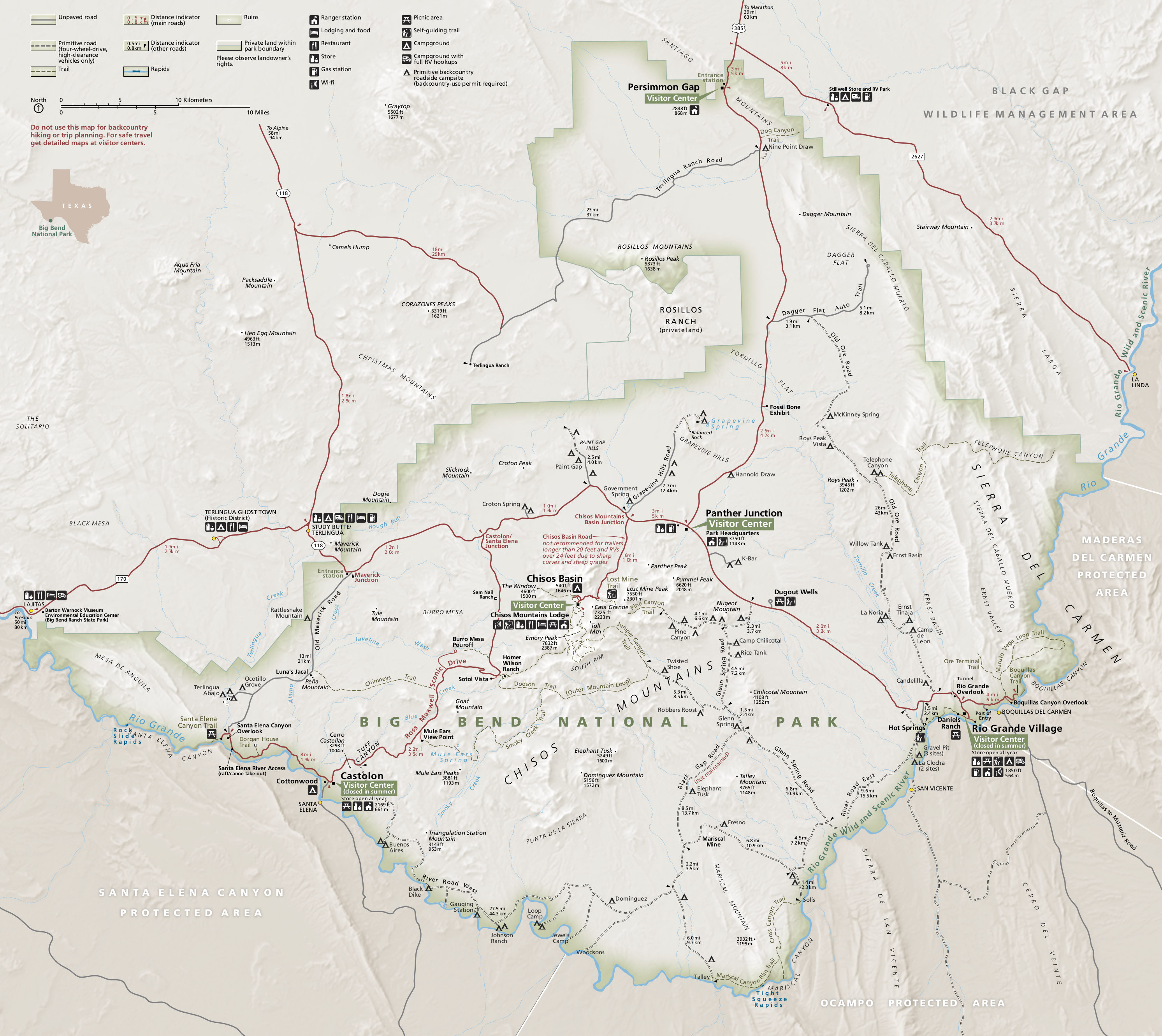
Glenn Springs is an uninhabited place in the state of Texas, United States, which is of historical importance. The Glenn Springs area was a natural spring providing water for Apache and Kiowa routing the Grand Indian Crossing passage at Boquillas. The Comanche tribes beseech the fresh water crossing on the Comanche Trail during their equine incursions from and to the Mexican Plateau, Sierra Madre Oriental, and the Trans-Mexican Volcanic Belt regions of Mexico. The rural settlement is located 11 miles (16 kilometers) south-southeast of the Panther Junction visitor center in what is now the Big Bend National Park, and is accessible only by high-clearance vehicle. The National Park Service maintains a back-country campground at Glenn Springs. Military occupation Glenn Springs was a military encampment, which was attacked by the troops of the Mexican General Pancho Villa on 5 May 1916, killing one civilian, three U.S. Army soldiers, and wounding several other troops. The Glenn Spring ... [...More Info...] [...Related Items...] OR: [Wikipedia] [Google] [Baidu] |
United States
The United States of America (U.S.A. or USA), commonly known as the United States (U.S. or US) or America, is a country primarily located in North America. It consists of 50 states, a federal district, five major unincorporated territories, nine Minor Outlying Islands, and 326 Indian reservations. The United States is also in free association with three Pacific Island sovereign states: the Federated States of Micronesia, the Marshall Islands, and the Republic of Palau. It is the world's third-largest country by both land and total area. It shares land borders with Canada to its north and with Mexico to its south and has maritime borders with the Bahamas, Cuba, Russia, and other nations. With a population of over 333 million, it is the most populous country in the Americas and the third most populous in the world. The national capital of the United States is Washington, D.C. and its most populous city and principal financial center is New York City. Paleo-Americ ... [...More Info...] [...Related Items...] OR: [Wikipedia] [Google] [Baidu] |
Sierra Madre Oriental
The Sierra Madre Oriental () is a mountain range in northeastern Mexico. The Sierra Madre Oriental is part of the American Cordillera, a chain of mountain ranges (cordillera) that consists of an almost continuous sequence of mountain ranges that form the western "backbone" of North America, Central America, South America, and Antarctica. Setting Spanning the Sierra Madre Oriental runs from the Rio Grande on the border between Coahuila and Texas south through Nuevo León, southwest Tamaulipas, San Luis Potosí, Querétaro, and Hidalgo to northern Puebla, where it joins with the east-west running Eje Volcánico Transversal of central Mexico. The northernmost are the Sierra del Burro and the Sierra del Carmen which reach the border with the United States at the Rio Grande. North of the Rio Grande, the range continues northwestward into Texas and beyond as the Davis and Guadalupe Ranges. Mexico's Gulf Coastal Plain lies to the east of the range, between the mountains and the Gul ... [...More Info...] [...Related Items...] OR: [Wikipedia] [Google] [Baidu] |
Trans-Pecos
The Trans-Pecos, as originally defined in 1887 by the Texas geologist Robert T. Hill, is the portion of Texas that lies west of the Pecos River. The term is considered synonymous with Far West Texas, a subdivision of West Texas. The Trans-Pecos is part of the Chihuahuan Desert, the largest desert in North America. It is the most mountainous and arid portion of the state, and most of its vast area (outside the city of El Paso) is sparsely populated. Among the nine counties in the region are the five largest counties by area in Texas and eight of the eleven largest in the state. The area is known for the natural environment of the Big Bend and the gorge of the Rio Grande, part of which has been designated a National Wild and Scenic Rivers System. With the notable exceptions of Big Bend Ranch State Park, Big Bend National Park and the Guadalupe Mountains National Park, the vast majority of the Trans-Pecos region consists of privately owned ranchland. However, most of the region ... [...More Info...] [...Related Items...] OR: [Wikipedia] [Google] [Baidu] |
Chisos Mountains
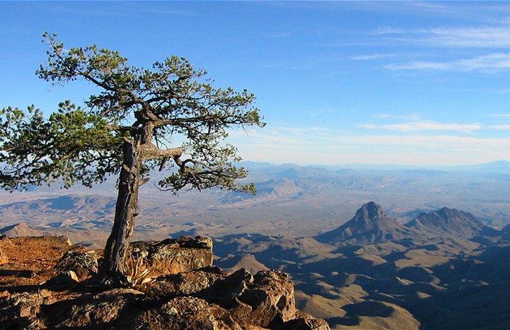
The Chisos Mountains, also known as the Chisos, are a mountain range located in the Big Bend area of the Trans-Pecos region of Texas, United States. The mountain system covers 40 square miles (104 square km) and is contained entirely within the boundaries of Big Bend National Park, making it the only mountain range in the United States fully contained within a national park. The Chisos Mountains are the southernmost mountain range in the mainland United States. The Chisos Mountains were created by volcanic activity during the Eocene Epoch 35-44 million years ago. The highest point in the Chisos Mountain range is Emory Peak at above sea level. Location The Chisos Mountains are located in Big Bend National Park. The range of mountains extends twenty miles from Punta de la Sierra in the southwest to Panther Junction in the northeast. An extensive trail system and permit-required backcountry campsites are maintained by Big Bend National Park for its visitors. The Northeast Rim ... [...More Info...] [...Related Items...] OR: [Wikipedia] [Google] [Baidu] |
Big Bend (Texas)
__NOTOC__ The Big Bend is part of the Trans-Pecos region in southwestern Texas, United States along the border with Mexico, north of the prominent bend in the Rio Grande for which the region is named. Here the Rio Grande passes between the Chisos Mountains in Texas and the Sierra Madre Oriental in Mexico as it changes from running east-southeast to north-northeast. The region covers three counties: Presidio County to the west, Brewster County to the east, and Jeff Davis County to the north. The region is rugged, sparsely populated Chihuahua Desert, including the Chisos Mountains, Chinati Mountains, and the Davis Mountains. The region has well over of public lands, including Big Bend National Park (801,163 acres) and Big Bend Ranch State Park (300,000 acres), Black Gap Wildlife Management Area (103,000 acres),Texas Parks and WildlifeBlack Gap Wildlife Management Area(accessed Oct 30, 2022) Chinati Mountains State Natural Area (39,000 acres)Texas Parks and Wildlife,hinati M ... [...More Info...] [...Related Items...] OR: [Wikipedia] [Google] [Baidu] |
Euphorbia Antisyphilitica
''Euphorbia antisyphilitica'' is a species of flowering plant in the spurge family Euphorbiaceae. It is native to the Trans-Pecos of Texas and southern New Mexico in the United States as well as Chihuahua, Coahuila, Hidalgo, and Querétaro in Mexico. Common names include candelilla and wax plant, but the latter is more often applied to members of the unrelated genus '' Hoya''. It is shrubby and has densely clustered, erect, essentially leafless stems that are covered in wax to prevent transpiration. Uses The white sap of ''E. antisyphilitica'' was historically used in Mexico to treat sexually-transmitted diseases. Commercial harvesting of candelilla wax began at the start of the twentieth century, with demand greatly increasing during World War I and II. This industry largely disappeared following the end of World War II due to diminished candelilla populations and the availability of cheaper petroleum-based waxes. Later on however, new uses were found for the wax mainly in the ... [...More Info...] [...Related Items...] OR: [Wikipedia] [Google] [Baidu] |
Spanish Texas
Spanish Texas was one of the interior provinces of the colonial Viceroyalty of New Spain from 1690 until 1821. The term "interior provinces" first appeared in 1712, as an expression meaning "far away" provinces. It was only in 1776 that a legal jurisdiction called "Interior Provinces" was created. Spain claimed ownership of the territory in 1519, which comprised part of the present-day U.S. state of Texas, including the land north of the Medina and Nueces Rivers, but did not attempt to colonize the area until after locating evidence of the failed French colony of Fort Saint Louis in 1689. In 1690 Alonso de León escorted several Catholic missionaries to east Texas, where they established the first mission in Texas. When native tribes resisted the Spanish invasion of their homeland, the missionaries returned to Mexico, abandoning Texas for the next two decades. The Spanish returned to southeastern Texas in 1716, establishing several missions and a presidio to maintain a ... [...More Info...] [...Related Items...] OR: [Wikipedia] [Google] [Baidu] |
Columbus, New Mexico
Columbus is a village in Luna County, New Mexico, United States, about north of the Mexico–United States border, Mexican border. It is considered a place of historical interest, as the scene of Battle of Columbus (1916), a 1916 attack by Mexico, Mexican revolutionary leader Pancho Villa, Francisco "Pancho" Villa that caused America to send 10,000 troops there in the Mexican Expedition (originally referred to as the "punitive Mexican Expedition"). Columbus's population was 1,664 at the 2010 United States Census, 2010 census. History Early history (1891–1910s) Columbus was established in 1891 just across the Mexican border from Palomas, Chihuahua, and named after 15th-century explorer Christopher Columbus. In 1902, the village was moved north when the El Paso and Southwestern Railroad built its Columbus station. This station is now converted into a museum run by the Columbus Historical Society. About 1905, it was a very small town with a population of about 100, two of those ea ... [...More Info...] [...Related Items...] OR: [Wikipedia] [Google] [Baidu] |
Raid On Glenn Springs
The raid on Glenn Springs occurred on the night of May 5–6, 1916, when Mexican Villistas and Carrancistas attacked the towns of Boquillas and Glenn Springs, Texas. In Glenn Springs, the raiders burned several buildings and fought a three-hour battle with a small force of American soldiers who were stationed there. At the same time, a second party of rebels robbed a general store and a silver mine in Boquillas. Four Americans were killed and the rebels took two hostages to Coahuila. In response to the attack, the United States Army launched a short punitive expedition into Mexico, fought with the rebels, and rescued the captives. Background Following the Mexican federal victory at the Battle of Celaya in April 1915, Mexican rebel Pancho Villa led the remnants of his once large army back to northern Mexico. By 1916, Villa and his men were in desperate need of food and provisions to continue their revolution, so they devised a plan to raid the American border town of Columbus, ... [...More Info...] [...Related Items...] OR: [Wikipedia] [Google] [Baidu] |
Pancho Villa
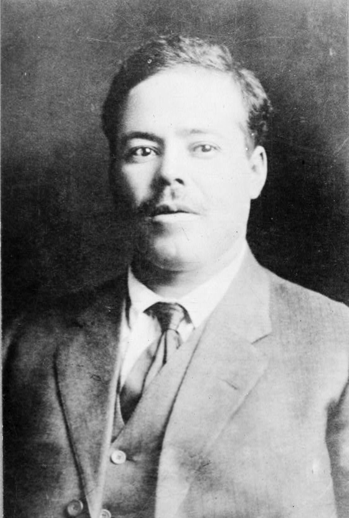
Francisco "Pancho" Villa (,"Villa" ''Collins English Dictionary''. ; ; born José Doroteo Arango Arámbula, 5 June 1878 – 20 July 1923) was a general in the Mexican Revolution. He was a key figure in the revolutionary movement that forced out President Porfirio Díaz and brought Francisco I. Madero to power in 1911. When Madero was ousted by a coup led by General Victoriano Huerta in February 1913, he led anti-Huerta forces in the Constitutionalist Army 1913–14. The commander of the coalition was civilian governor of Coahuila Venustiano Carranza. After the defeat and exile of Huerta in July 1914, Villa broke with Carranza. Villa dominated the Convention of Aguascalientes, meeting of revolutionary generals that excluded Carranza and helped create a coalition government. Emiliano Zapata and Villa ... [...More Info...] [...Related Items...] OR: [Wikipedia] [Google] [Baidu] |
Big Bend National Park
Big Bend National Park is an American national park located in West Texas, bordering Mexico. The park has national significance as the largest protected area of Chihuahuan Desert topography and ecology in the United States, and was named after a large bend in the Rio Grande/Río Bravo. The park protects more than 1,200 species of plants, more than 450 species of birds, 56 species of reptiles, and 75 species of mammals. Additional park activities include scenic drives, programs led by Big Bend park rangers, and stargazing. The area has a rich cultural history, from archeological sites dating back nearly 10,000 years to more recent pioneers, ranchers, and miners. The Chisos Mountains are located in the park, and are the only mountain range in the United States to be fully contained within the boundary of a national park. Geological features in the park include sea fossils and dinosaur bones, as well as volcanic dikes. The park encompasses an area of , entirely within Brewst ... [...More Info...] [...Related Items...] OR: [Wikipedia] [Google] [Baidu] |
Panther Junction, Texas
Panther Junction is an unincorporated community located in Brewster County, Texas, United States. The community is located inside Big Bend National Park. The ZIP Code serving the community is 79834, which is addressed to Big Bend National Park. Geography Panther Junction is located at latitude 29.329 degrees north and longitude 103.205 degrees west (29.329, -103.205); or approximately twenty miles east of Study Butte. The elevation for the community is above sea level. Climate Education Panther Junction is served by the San Vicente Independent School District, which located its school facility there circa 1951. The district covers most of Big Bend National Park and Southeastern Brewster County. High schoolers zoned to San Vicente ISD attend school in Terlingua Common School District's Big Bend High School. Previously Alpine High School of the Alpine Independent School District The Alpine Independent School District is a school district based in Alpine, Texas, United S ... [...More Info...] [...Related Items...] OR: [Wikipedia] [Google] [Baidu] |


