|
Glen Doll
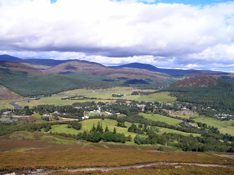
Glen Doll, also sometimes spelt Glendoll, lies within the Cairngorms National Park, Scotland, at the top of Glen Clova, in an area of steep hills, corries and Munros. It includes the Corrie Fee National Nature Reserve, which has many endangered plants.Glen Doll at angusglens.co.uk, accessed 17 January 2009 The nearest town is .Glen Doll at forestry.gov.uk, accessed 17 January 2009 The glen is in the south eastern |
Scottish Rights Of Way And Access Society
The Scottish Rights of Way and Access Society was formed in 1845 as the 'Association for the Protection of Public Rights of Roadway in and around Edinburgh'. By 1885 it had become the 'Scottish Rights of Way and Recreation Society' and traded as the 'Scottish Rights of Way Society between 1993 and 1999. The Society which also promotes itself through the shortened title ‘ScotWays’, is a charity and, since 1946, a company limited by guarantee based in Edinburgh Edinburgh ( ; gd, Dùn Èideann ) is the capital city of Scotland and one of its 32 Council areas of Scotland, council areas. Historically part of the county of Midlothian (interchangeably Edinburghshire before 1921), it is located in Lothian .... Its aims relate to the preservation and improvement of access to the Scottish countryside. The Society first published a book ''Scottish Hill Tracks'' in 1947. Now in its fifth edition, it details routes for walkers, cyclists and horse-riders.https://www.scotways.com/scot ... [...More Info...] [...Related Items...] OR: [Wikipedia] [Google] [Baidu] |
Forestry Commission
The Forestry Commission is a non-ministerial government department responsible for the management of publicly owned forests and the regulation of both public and private forestry in England. The Forestry Commission was previously also responsible for Forestry in Wales and Scotland. However, on 1 April 2013, Forestry Commission Wales merged with other agencies to become Natural Resources Wales, whilst two new bodies (Forestry and Land Scotland and Scottish Forestry) were established in Scotland on 1 April 2019. The Forestry Commission was established in 1919 to expand Britain's forests and woodland, which had been severely depleted during the First World War. The Commission bought large amounts of agricultural land on behalf of the state, eventually becoming the largest manager of land in Britain. Today, the Forestry Commission is divided into three divisions: Forestry England, Forestry Commission and Forest Research. Over time the purpose of the Commission broadened to includ ... [...More Info...] [...Related Items...] OR: [Wikipedia] [Google] [Baidu] |
Mayar (mountain)
Mayar is a mountain in the Grampians, in Angus, Scotland. It is usually climbed together with its near neighbour, Driesh Driesh (Gaelic: ''Dris'') is a mountain located in the Grampians of Scotland. Apart from Mount Keen (939 m/3,080 ft), it is the most easterly of the Munro peaks. Located several miles north of the town of Kirriemuir in Angus, the closeness .... At an elevation of 928 m, it is the 564th highest peak in the British Isles and the 253rd tallest in Scotland. References Munros Mountains and hills of the Eastern Highlands Mountains and hills of Angus, Scotland {{Europe-mountain-stub ... [...More Info...] [...Related Items...] OR: [Wikipedia] [Google] [Baidu] |
Driesh
Driesh (Gaelic: ''Dris'') is a mountain located in the Grampians of Scotland. Apart from Mount Keen (939 m/3,080 ft), it is the most easterly of the Munro peaks. Located several miles north of the town of Kirriemuir in Angus, the closeness of Driesh to the city of Dundee makes it a popular Munro with locals; in many ways making it the Dundonian equivalent to Ben Lomond near Glasgow Glasgow ( ; sco, Glesca or ; gd, Glaschu ) is the most populous city in Scotland and the fourth-most populous city in the United Kingdom, as well as being the 27th largest city by population in Europe. In 2020, it had an estimated popul .... References {{Scottish Munros section 7 Munros Mountains and hills of the Eastern Highlands Mountains and hills of Angus, Scotland ... [...More Info...] [...Related Items...] OR: [Wikipedia] [Google] [Baidu] |
Glen Prosen
The Five Glens of Angus are the five Highland glens located in the western portion of the Angus region of Scotland. The five glens from westernmost to easternmost are: *Glen Isla *Glen Prosen *Glen Clova *Glen Lethnot * Glen Esk Glen Clova is remarkable for its glaciated landscape, with the deep trough-heads of Glen Doll and Corrie Fee, an array of classic corries (glacial cirques) along its NE rim - notably Corrie Bonhard, Corrie of Clova, Corrie Brandy and Corrie Wharrel, and a cluster of diverse "rock slope failures" (rock slides, avalanches, and deformations) including The Rives on Cairn Broadlands, and several in the corries Glen Clova's 1940s postwoman, Jean Cameron, changed the uniform for women, having asked to wear trousers for her rounds, they were named 'Camerons' after her. In 2015 red kites at the Gannochy estate in Glenesk were found to have been stealing swimmers' clothing to line their nest. See also * Kilry Glen Kilry Glen, in Angus, Scotland, is the glen ... [...More Info...] [...Related Items...] OR: [Wikipedia] [Google] [Baidu] |
House Of Lords
The House of Lords, also known as the House of Peers, is the Bicameralism, upper house of the Parliament of the United Kingdom. Membership is by Life peer, appointment, Hereditary peer, heredity or Lords Spiritual, official function. Like the House of Commons of the United Kingdom, House of Commons, it meets in the Palace of Westminster in London, England. The House of Lords scrutinises Bill (law), bills that have been approved by the House of Commons. It regularly reviews and amends bills from the Commons. While it is unable to prevent bills passing into law, except in certain limited circumstances, it can delay bills and force the Commons to reconsider their decisions. In this capacity, the House of Lords acts as a check on the more powerful House of Commons that is independent of the electoral process. While members of the Lords may also take on roles as government ministers, high-ranking officials such as cabinet ministers are usually drawn from the Commons. The House of Lo ... [...More Info...] [...Related Items...] OR: [Wikipedia] [Google] [Baidu] |
Australia
Australia, officially the Commonwealth of Australia, is a Sovereign state, sovereign country comprising the mainland of the Australia (continent), Australian continent, the island of Tasmania, and numerous List of islands of Australia, smaller islands. With an area of , Australia is the largest country by area in Oceania and the world's List of countries and dependencies by area, sixth-largest country. Australia is the oldest, flattest, and driest inhabited continent, with the least fertile soils. It is a Megadiverse countries, megadiverse country, and its size gives it a wide variety of landscapes and climates, with Deserts of Australia, deserts in the centre, tropical Forests of Australia, rainforests in the north-east, and List of mountains in Australia, mountain ranges in the south-east. The ancestors of Aboriginal Australians began arriving from south east Asia approximately Early human migrations#Nearby Oceania, 65,000 years ago, during the Last Glacial Period, last i ... [...More Info...] [...Related Items...] OR: [Wikipedia] [Google] [Baidu] |
Cairngorms National Park
Cairngorms National Park ( gd, Pàirc Nàiseanta a' Mhonaidh Ruaidh) is a national park in northeast Scotland, established in 2003. It was the second of two national parks established by the Scottish Parliament, after Loch Lomond and The Trossachs National Park, which was set up in 2002. The park covers the Cairngorms range of mountains, and surrounding hills. Already the largest national park in the United Kingdom, in 2010 it was expanded into Perth and Kinross. Roughly 18,000 people reside within the 4,528 square kilometre national park. The largest communities are Aviemore, Ballater, Braemar, Grantown-on-Spey, Kingussie, Newtonmore, and Tomintoul. Tourism makes up about 80% of the economy. In 2018, 1.9 million tourism visits were recorded. The majority of visitors are domestic, with 25 per cent coming from elsewhere in the UK, and 21 per cent being from other countries. Geography The Cairngorms National Park covers an area of in the council areas of Aberdeenshire, Mo ... [...More Info...] [...Related Items...] OR: [Wikipedia] [Google] [Baidu] |
Braemar
Braemar is a village in Aberdeenshire, Scotland, around west of Aberdeen in the Highlands. It is the closest significantly-sized settlement to the upper course of the River Dee sitting at an elevation of . The Gaelic ''Bràigh Mhàrr'' properly refers to the area of upper Marr (as it literally means), i.e. the area of Marr to the west of Aboyne, the village itself being Castleton of Braemar (''Baile a' Chaisteil''). The village used to be known as ''Cinn Drochaid'' (bridge end); ''Baile a' Chaisteil'' referred to only the part of the village on the east bank of the river, the part on the west bank being known as ''Ach an Droighinn'' (thorn field). Geography Braemar is approached from the South on the A93 from Glen Clunie and the Cairnwell Pass and from the East also on the A93 from Deeside. Braemar can be approached on foot from the West through Glen Tilt, Glen Feshie, Glen Dee (by the Lairig Ghru), and Glen Derry (by the Lairig an Laoigh). Braemar is within a one-and-a-hal ... [...More Info...] [...Related Items...] OR: [Wikipedia] [Google] [Baidu] |
Grampian Mountains
The Grampian Mountains (''Am Monadh'' in Scottish Gaelic, Gaelic) is one of the three major mountain ranges in Scotland, that together occupy about half of Scotland. The other two ranges are the Northwest Highlands and the Southern Uplands. The Grampian range extends southwest to northeast between the Highland Boundary Fault and the Great Glen. The range includes many of the highest mountains in the British Isles, including Ben Nevis (whose peak contains the highest point in the British Isles at above sea level) and Ben Macdhui (Scotland), Ben Macdui (whose peak contains second-highest at ). A number of rivers and streams rise in the Grampians, including the River Tay, Tay, River Spey, Spey, Cowie Water, Burn of Muchalls, Burn of Pheppie, Burn of Elsick, Cairnie Burn, River Don, Aberdeenshire, Don, River Dee, Aberdeenshire, Dee and River South Esk, Esk. The area is generally sparsely populated. There is some ambiguity about the extent of the range, and until the nineteenth c ... [...More Info...] [...Related Items...] OR: [Wikipedia] [Google] [Baidu] |


_Named_(HR).png)