|
Gibson, Louisiana
Gibson is an unincorporated community in Terrebonne Parish, Louisiana, United States. The zip code is 70356. It is part of the Houma– Bayou Cane–Thibodaux Metropolitan Statistical Area. Geography Gibson is located at , on LA Highway 182 between Houma and Morgan City. Education Terrebonne Parish School District Terrebonne Parish School District is a school district headquartered in Bayou Cane, an unincorporated area in Terrebonne Parish, Louisiana, near Houma. The district serves residents in Terrebonne Parish, including the city of Houma as well as the ... operates public schools. Gibson Elementary School is located in the community. " Gibson Elementary School. Retrieved on July 27, 2010. References [...More Info...] [...Related Items...] OR: [Wikipedia] [Google] [Baidu] |
Unincorporated Area
An unincorporated area is a region that is not governed by a local municipal corporation. Widespread unincorporated communities and areas are a distinguishing feature of the United States and Canada. Most other countries of the world either have no unincorporated areas at all or these are very rare: typically remote, outlying, sparsely populated or List of uninhabited regions, uninhabited areas. By country Argentina In Argentina, the provinces of Chubut Province, Chubut, Córdoba Province (Argentina), Córdoba, Entre Ríos Province, Entre Ríos, Formosa Province, Formosa, Neuquén Province, Neuquén, Río Negro Province, Río Negro, San Luis Province, San Luis, Santa Cruz Province, Argentina, Santa Cruz, Santiago del Estero Province, Santiago del Estero, Tierra del Fuego Province, Argentina, Tierra del Fuego, and Tucumán Province, Tucumán have areas that are outside any municipality or commune. Australia Unlike many other countries, Australia has only local government in Aus ... [...More Info...] [...Related Items...] OR: [Wikipedia] [Google] [Baidu] |
Terrebonne Parish, Louisiana
Terrebonne Parish ( ; French: ''Paroisse de Terrebonne'') is a parish located in the southern part of the U.S. state of Louisiana. At the 2010 census, the population was 111,860, and 110,461 in 2019. In 2020, its population declined to 109,580. The parish seat is Houma. The parish was founded in 1822. Terrebonne Parish is part of the Houma-Thibodaux metropolitan statistical area. It is the fifth-largest parish in the state in terms of land area, and it has been a center of Cajun culture since the 18th century. More than 10% of its residents speak French at home. Ray Authement, who was the fifth president of the University of Louisiana at Lafayette, serving from 1974 to 2008 and the longest-serving president of a public university in the United States, was born in rural Terrebonne Parish in 1928, near Chauvin. In 2014 Juan Pickett, former Assistant District Attorney, was elected unopposed in the 32nd Judicial District as the first black judge in Terrebone Parish history. [...More Info...] [...Related Items...] OR: [Wikipedia] [Google] [Baidu] |
North American Central Time Zone
The North American Central Time Zone (CT) is a time zone in parts of Canada, the United States, Mexico, Central America, some Caribbean Islands, and part of the Eastern Pacific Ocean. Central Standard Time (CST) is six hours behind Coordinated Universal Time (UTC). During summer, most of the zone uses daylight saving time (DST), and changes to Central Daylight Time (CDT) which is five hours behind UTC. The largest city in the Central Time Zone is Mexico City; the Mexico City metropolitan area is the largest metropolitan area in the zone and in North America. Regions using (North American) Central Time Canada The province of Manitoba is the only province or territory in Canada that observes Central Time in all areas. The following Canadian provinces and territories observe Central Time in the areas noted, while their other areas observe Eastern Time: * Nunavut (territory): western areas (most of Kivalliq Region and part of Qikiqtaaluk Region) * Ontario (province): a port ... [...More Info...] [...Related Items...] OR: [Wikipedia] [Google] [Baidu] |
Area Code 985
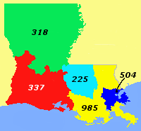
Area code 985 is the telephone area code for southeastern Louisiana, excluding the inner ring of the New Orleans area. The area code was created in 2001 when it was split off from area code 504. Area code 985 also used to include areas southeast of New Orleans. However, in 2007, these areas switched back to 504. These communities are on both sides of the Mississippi River in "lower" Plaquemines Parish, including Pointe à la Hache on the east bank, with Port Sulphur, Buras, and Boothville on the west bank. The area's local switching facilities were almost destroyed due to flooding from Hurricane Katrina. Since the nearest switching facilities were in New Orleans, it was decided to put these downriver communities back in 504. Permissive use of 504 alongside 985 to reach these areas once again began on July 29, 2007; mandatory use of 504 began on July 1, 2008. Cities covered by area code 985 * Abita Springs * Amite * Angie * Bayou L'Ourse * Berwick *Bogalusa *Bourg * Boutte * ... [...More Info...] [...Related Items...] OR: [Wikipedia] [Google] [Baidu] |
Houma, Louisiana
Houma ( ) is the largest city in, and the parish seat of, Terrebonne Parish in the U.S. state of Louisiana. It is also the largest principal city of the Houma– Bayou Cane–Thibodaux metropolitan statistical area. The city's government was absorbed by the parish in 1984, which currently operates as the Terrebonne Parish Consolidated Government. The population was 33,727 at the 2010 census, an increase of 1,334 over the 2000 census tabulation of 32,393. In 2020, the population estimates program determined 32,467 people lived in the city. At the 2020 census, its population rebounded to 33,406. Many unincorporated areas are adjacent to the city of Houma. The largest, Bayou Cane, is an urbanized area commonly referred to by locals as being part of Houma, but it is not included in the city's census counts, and is a separate census-designated place. If the populations of the urbanized census-designated places were included with that of the city of Houma, the total would ... [...More Info...] [...Related Items...] OR: [Wikipedia] [Google] [Baidu] |
Bayou Cane, Louisiana
Bayou Cane is a census-designated place (CDP) in Terrebonne Parish, Louisiana, United States. It is located just north of Houma and had a population of 19,770 in 2020. Bayou Cane is the principal city of the Houma–Bayou Cane–Thibodaux metropolitan statistical area, which includes all of Terrebonne and Lafourche parishes. Geography Bayou Cane is located at (29.626285, -90.748396). According to the United States Census Bureau, the CDP has a total area of , all land. Demographics As of the 2020 United States census, there were 19,770 people, 7,500 households, and 4,761 families residing in the CDP. Education Bayou Cane is in the Terrebonne Parish School Board Terrebonne Parish School District is a school district headquartered in Bayou Cane, an unincorporated area in Terrebonne Parish, Louisiana, near Houma. The district serves residents in Terrebonne Parish, including the city of Houma as well as the ... district. References External linksBayou Cane's daily ... [...More Info...] [...Related Items...] OR: [Wikipedia] [Google] [Baidu] |
Thibodaux, Louisiana
Thibodaux ( ) is a city in, and the parish seat of, Lafourche Parish, Louisiana, United States, along the banks of Bayou Lafourche in the northwestern part of the parish. The population was 15,948 at the 2020 census. Thibodaux is a principal city of the Houma– Bayou Cane–Thibodaux metropolitan statistical area. Thibodaux is nicknamed the "Queen City of Lafourche." History The first documented Native American inhabitants of the Thibodaux area were the Chawasha, a small tribe related to the Chitimacha of the upper Bayou Lafourche. The first settlers of European descent in this area arrived in the 18th century, when Louisiana was the Spanish province of Luisiana. They consisted of French nationals and Louisiana-born French and German creoles, followed shortly by Spanish and French Acadian immigrants. The colonists gradually began to import Africans in bondage as slaves to work on and develop rice and sugar cane plantations. The United States acquired Louisiana fro ... [...More Info...] [...Related Items...] OR: [Wikipedia] [Google] [Baidu] |
LA Highway 182
LA most frequently refers to Los Angeles, the second largest city in the United States. La, LA, or L.A. may also refer to: Arts and entertainment Music * La (musical note), or A, the sixth note * "L.A.", a song by Elliott Smith on ''Figure 8'' (album) * ''L.A.'' (EP), by Teddy Thompson * ''L.A. (Light Album)'', a Beach Boys album * "L.A." (Neil Young song), 1973 * The La's, an English rock band * L.A. Reid, a prominent music producer * Yung L.A., a rapper * Lady A, an American country music trio * "L.A." (Amy Macdonald song), 2007 * "La", a song by Australian-Israeli singer-songwriter Old Man River Other media * l(a, a poem by E. E. Cummings * La (Tarzan), fictional queen of the lost city of Opar (Tarzan) * ''Lá'', later known as Lá Nua, an Irish language newspaper * La7, an Italian television channel * LucasArts, an American video game developer and publisher * Liber Annuus, academic journal Business, organizations, and government agencies * L.A. Screenings, a tel ... [...More Info...] [...Related Items...] OR: [Wikipedia] [Google] [Baidu] |
Morgan City, Louisiana
Morgan City is a small city in St. Mary and lower St. Martin parishes in the U.S. State of Louisiana. The population was 12,404 at the 2010 census. Known for being “right in the middle of everywhere”, Morgan City is located 68 miles (109 km) southeast of Lafayette, 64 miles (103 km) south of Baton Rouge, and 86 miles (138 km) west of New Orleans Morgan City sits on the banks of the Atchafalaya River. The town was originally named "Tiger Island" by surveyors appointed by U.S. Secretary of War John Calhoun, because of a particular type of wild cat seen in the area. It was later changed for a time to "Brashear City," named after Walter Brashear, a prominent Kentucky physician who had purchased large tracts of land and acquired numerous sugar mills in the area. It was incorporated in 1860. History Capture of Brashear City During the American Civil War, the Star Fort of Fort Brashear was the larger of two works erected by the Union Army occupying the city to de ... [...More Info...] [...Related Items...] OR: [Wikipedia] [Google] [Baidu] |
Terrebonne Parish School District
Terrebonne Parish School District is a school district headquartered in Bayou Cane, an unincorporated area in Terrebonne Parish, Louisiana, near Houma. The district serves residents in Terrebonne Parish, including the city of Houma as well as the surrounding unincorporated areas of Bayou Cane, Bourg, Chauvin, Gibson, Gray, Montegut, and Schriever. Residents of select portions of Lafourche Parish (particularly in parts of Grand Bois and Bourg) may attend schools in the Terrebonne Parish School District. Students with certain medical problems and children of certain teachers residing in Terrebonne Parish may attend school in the Lafourche Parish Public Schools only if superintendents of both systems approve it on a case-by-case basis. History The school district made academic improvement between 2015 and 2016; it received a higher score in the Louisiana Department of Education rankings, 95.1 from 90.5; both levels are classified as "B". School uniforms The school district re ... [...More Info...] [...Related Items...] OR: [Wikipedia] [Google] [Baidu] |


