|
German Shoe Road
The German Shoe Road (german: Deutsche Schuhstraße) is one of several tourist-oriented, themed routes in southern Rheinhessen and in the West Palatinate in the German state of Rhineland-Palatinate. It is a circular route of more than 300 km largely running within the Palatine Forest-North Vosges Biosphere Reserve often on scenic secondary roads. Route The German Shoe Road includes the following way stations: Alzey, Wendelsheim, Nack, Bechenheim, Nieder-Wiesen, Kriegsfeld, Unterthierwasen, Bastenhaus-Dannenfels, Marienthal, Falkenstein, Enkenbach-Alsenborn, Hochspeyer, Johanniskreuz, Hauenstein, Dahn, Busenberg, Fischbach, Eppenbrunn, Trulben, Pirmasens, Walshausen, Rieschweiler-Mühlbach, Wallhalben, Mittelbrunn, Landstuhl, Miesenbach, Altenglan, Aschbach, Lauterecken, Meisenheim, Fürfeld, Wonsheim, Wendelsheim, Alzey Near Pirmasens the German Shoe Road divides into various branches that link e.g. Rodalben and Waldfischbach-Burgalben as well as Lemberg. Hi ... [...More Info...] [...Related Items...] OR: [Wikipedia] [Google] [Baidu] |
Tourist
Tourism is travel for pleasure or business; also the theory and practice of touring, the business of attracting, accommodating, and entertaining tourists, and the business of operating tours. The World Tourism Organization defines tourism more generally, in terms which go "beyond the common perception of tourism as being limited to holiday activity only", as people "travelling to and staying in places outside their usual environment for not more than one consecutive year for leisure and not less than 24 hours, business and other purposes". Tourism can be domestic (within the traveller's own country) or international, and international tourism has both incoming and outgoing implications on a country's balance of payments. Tourism numbers declined as a result of a strong economic slowdown (the late-2000s recession) between the second half of 2008 and the end of 2009, and in consequence of the outbreak of the 2009 H1N1 influenza virus, but slowly recovered until the COVID-19 ... [...More Info...] [...Related Items...] OR: [Wikipedia] [Google] [Baidu] |
Johanniskreuz
Johanniskreuz is a tiny hamlet in the middle of the Palatine Forest in Germany and belongs to the municipality of Trippstadt in the district of Kaiserslautern in the state of Rhineland-Palatinate. Geography Location Johanniskreuz lies in a saddle at about , north of the midpoint of the central massif of the Palatine Forest, the Frankenweide, whose surrounding peaks are only a little higher. The Frankenweide, across which the Palatine Watershed runs, is bounded to the west, north and east in the area of Johanniskreuz by the valleys of streams that rise near the hamlet. Immediately west of Johanniskreuz is the source of the Moosalb, a tributary of the Schwarzbach, which itself rises one kilometre southwest of Johanniskreuz. The waters of these streams initially flow westwards through the Blies and Saar rivers into the river Moselle and then on to the Rhine. A little to the east of Johanniskreuz is the source of another Schwarzbach, this time the left-hand headstream of ... [...More Info...] [...Related Items...] OR: [Wikipedia] [Google] [Baidu] |
Ramstein-Miesenbach
Ramstein-Miesenbach is a town in the district of Kaiserslautern in Rhineland-Palatinate in Germany, adjacent to the U.S. Ramstein Air Base. History As a result of the State of Rheinland-Pfalz administrative reform, Ramstein-Miesenbach, which has a population of approx. 9,200, was created on 7 June 1969 from the independent villages of Ramstein and Miesenbach. City designation was awarded in 1991. Ramstein-Miesenbach is the administrative center of the ''Verbandsgemeinde'' ("collective municipality") of Ramstein-Miesenbach which, with its approx. 19,100 inhabitants, is the largest Verbandsgemeinde in Kaiserslautern district. Ramstein During Roman times there was a village on the old east-west road north of the Western Palatinate swamps. Ceramic shards, coins and the remains of a Roman villa were found near "Unterschernauer" Mill thus demonstrating that people have lived in this area since Roman times. Ramstein is first mentioned in a document dated 2 June 1215. With this docume ... [...More Info...] [...Related Items...] OR: [Wikipedia] [Google] [Baidu] |
Landstuhl
Landstuhl () is a town in the Kaiserslautern district of Rhineland-Palatinate in Germany. It is the seat of ''Verbandsgemeinde Landstuhl'', a kind of "collective municipality." Landstuhl is situated on the north-west edge of the Palatinate Forest, west of Kaiserslautern. History Early history The earliest traces of human settlement in Landstuhl date from around 500 BC. The “heathen rock” (''Heidenfels'') from the Celtic period was a holy site until Roman times, and a Roman settlement dates from the 1st century. About 1152, Emperor Frederick I had Nanstein Castle built on the mountain south of town. Early Modern period During the 15th Century, the lords of Sickingen assumed responsibility for Landstuhl and the surrounding area. The most famous member of this dynasty was Franz von Sickingen. He converted the castle – Nanstein Castle (german: Burg Nanstein), the most visible landmark in Landstuhl and the surrounding area – into a dominating fortress. In August 1522 ... [...More Info...] [...Related Items...] OR: [Wikipedia] [Google] [Baidu] |
Mittelbrunn
Mittelbrunn is a municipality in the district of Kaiserslautern, in Rhineland-Palatinate, western Germany. Verena Chapel The Verena Chapel (german: Verenakapelle) in Mittelbrunn was first mentioned in 1496. The chapel was partially destroyed in the Thirty Years War (1618-1648). One last service was celebrated in 1718. Since at least the 18th century, the medieval In the history of Europe, the Middle Ages or medieval period lasted approximately from the late 5th to the late 15th centuries, similar to the Post-classical, post-classical period of World history (field), global history. It began with t ... chapel has been a decayed but eloquent presence in art and aesthetics. International relations Mittelbrunn is twinned with: * Saint-Désir-de-Lisieux, France (1981) References External links * * {{Authority control Municipalities in Rhineland-Palatinate 1230s establishments in the Holy Roman Empire Kaiserslautern (district) Populated places established ... [...More Info...] [...Related Items...] OR: [Wikipedia] [Google] [Baidu] |
Wallhalben
Wallhalben is a municipality in the Südwestpfalz district, in Rhineland-Palatinate, Germany. It is situated approximately 15 km northwest of Pirmasens, and 15 km northeast of Zweibrücken. Until 1 July 2014, when it became part of the ''Verbandsgemeinde'' ("collective municipality") Thaleischweiler-Wallhalben Thaleischweiler-Wallhalben is a ''Verbandsgemeinde'' ("collective municipality") in the Südwestpfalz district, in Rhineland-Palatinate, Germany Germany,, officially the Federal Republic of Germany, is a country in Central Europe. It ..., Wallhalben was the seat of the ''Verbandsgemeinde'' Wallhalben. References Südwestpfalz {{Südwestpfalz-geo-stub ... [...More Info...] [...Related Items...] OR: [Wikipedia] [Google] [Baidu] |
Rieschweiler-Mühlbach
Rieschweiler-Mühlbach is a municipality in Südwestpfalz district, in Rhineland-Palatinate, western Germany Germany,, officially the Federal Republic of Germany, is a country in Central Europe. It is the second most populous country in Europe after Russia, and the most populous member state of the European Union. Germany is situated betwe .... References Municipalities in Rhineland-Palatinate Südwestpfalz {{Südwestpfalz-geo-stub ... [...More Info...] [...Related Items...] OR: [Wikipedia] [Google] [Baidu] |
Walshausen
Walshausen is a German village in the Zweibrücken-Land municipality, in the Südwestpfalz district in the Rhineland-Palatinate Rhineland-Palatinate ( , ; german: link=no, Rheinland-Pfalz ; lb, Rheinland-Pfalz ; pfl, Rhoilond-Palz) is a western state of Germany. It covers and has about 4.05 million residents. It is the ninth largest and sixth most populous of the .... As of December 2020 it had 320 inhabitants. Walshausen is first mentioned in history in 1463. References Südwestpfalz {{Südwestpfalz-geo-stub ... [...More Info...] [...Related Items...] OR: [Wikipedia] [Google] [Baidu] |
Pirmasens
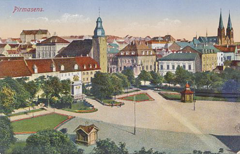
Pirmasens (; pfl, Bärmesens (also ''Bermesens'' or ''Bärmasens'')) is an independent town in Rhineland-Palatinate, Germany, near the border with France. It was famous for the manufacture of shoes. The surrounding rural district was called ''Landkreis Pirmasens'' from 1818 until 1997, when it was renamed to ''Südwestpfalz''. Pirmasens can be easily mistaken with ''Primasens'', of which means a first sense in Latin-derived languages (the first sense in Latin would be "primus sensus"). History Early years The first mention of "Pirminiseusna", a colony of Hornbach Abbey, dates from 860. The name derives from St. Pirminius, the founder of the monastery. During the period it was under rule of the Bishopric of Metz. It was passed to Diocese of Speyer in last the quarter of the 11th century, then was captured by County of Saarbrücken in 1100. In 1182, the County of Saarbrücken was divided by Simon II and Henry I, who were sons of Simon I. Pirmasens was given to the latter and He ... [...More Info...] [...Related Items...] OR: [Wikipedia] [Google] [Baidu] |
Trulben
Trulben is a municipality in Südwestpfalz district, in Rhineland-Palatinate, western Germany Germany,, officially the Federal Republic of Germany, is a country in Central Europe. It is the second most populous country in Europe after Russia, and the most populous member state of the European Union. Germany is situated betwe ... and belongs to the municipal association Pirmasens-Land. References Municipalities in Rhineland-Palatinate Südwestpfalz {{Südwestpfalz-geo-stub ... [...More Info...] [...Related Items...] OR: [Wikipedia] [Google] [Baidu] |
Eppenbrunn
Eppenbrunn is a municipality in Südwestpfalz district, in Rhineland-Palatinate, western Germany and belongs to the municipal association Pirmasens-Land. Within the municipality is the 1.5 km long bunter sandstone The Buntsandstein (German for ''coloured'' or ''colourful sandstone'') or Bunter sandstone is a lithostratigraphic and allostratigraphic unit (a sequence of rock strata) in the subsurface of large parts of west and central Europe. The Buntsands ... formation called the '' Altschlossfelsen'', which lies by the French border and was settled as early as Roman times. References Municipalities in Rhineland-Palatinate Palatinate Forest Südwestpfalz {{Südwestpfalz-geo-stub ... [...More Info...] [...Related Items...] OR: [Wikipedia] [Google] [Baidu] |
Fischbach Bei Dahn
Fischbach bei Dahn is a municipality in Südwestpfalz district, in Rhineland-Palatinate, western Germany. The hollow in which Fischbach lies is surrounded by hills rising to around 400 metres above sea level. The highest hills in the general area are: to the northeast the Große Eyberg (514 m) and, to the south, beyond the French border, the Maimont (512 m). The summits of both hills are about four kilometres from the village. When the US military began to downsize in the 1990s, the small US Army posts associated with Husterhoeh Kaserne (Pirmasens Pirmasens (; pfl, Bärmesens (also ''Bermesens'' or ''Bärmasens'')) is an independent town in Rhineland-Palatinate, Germany, near the border with France. It was famous for the manufacture of shoes. The surrounding rural district was called ''Lan ...) were returned to Germany, including ones located at Maßweiler, Munchweiler, Fischbach, and Clausen. References Municipalities in Rhineland-Palatinate Palatinate Forest Sou ... [...More Info...] [...Related Items...] OR: [Wikipedia] [Google] [Baidu] |

.jpg)


