|
Geography Of Nevada
The landlocked U.S. state of Nevada has a varied geography and is almost entirely within the Basin and Range Province and is broken up by many north–south mountain ranges. Most of these ranges have endorheic valleys between them. Overview Much of the northern part of the state is within the Great Basin, a mild desert that experiences hot temperatures in the summer and cold temperatures in the winter. Occasionally, moisture from the Arizona Monsoon will cause summer thunderstorms; Pacific storms may blanket the area with snow. The state's highest recorded temperature was in Laughlin (elevation of ) on June 29, 1994.National Climatic Data Center, Asheville, N.C., and Storm Phillips, Stormfax, Inc. The coldest recorded temperature was set in San Jacinto in 1972, in the northeastern portion of the state. The Humboldt River crosses the state from east to west across the northern part of the state, draining into the Humboldt Sink near Lovelock. Several rivers drain from the S ... [...More Info...] [...Related Items...] OR: [Wikipedia] [Google] [Baidu] |
Pyramid Lake (Nevada)
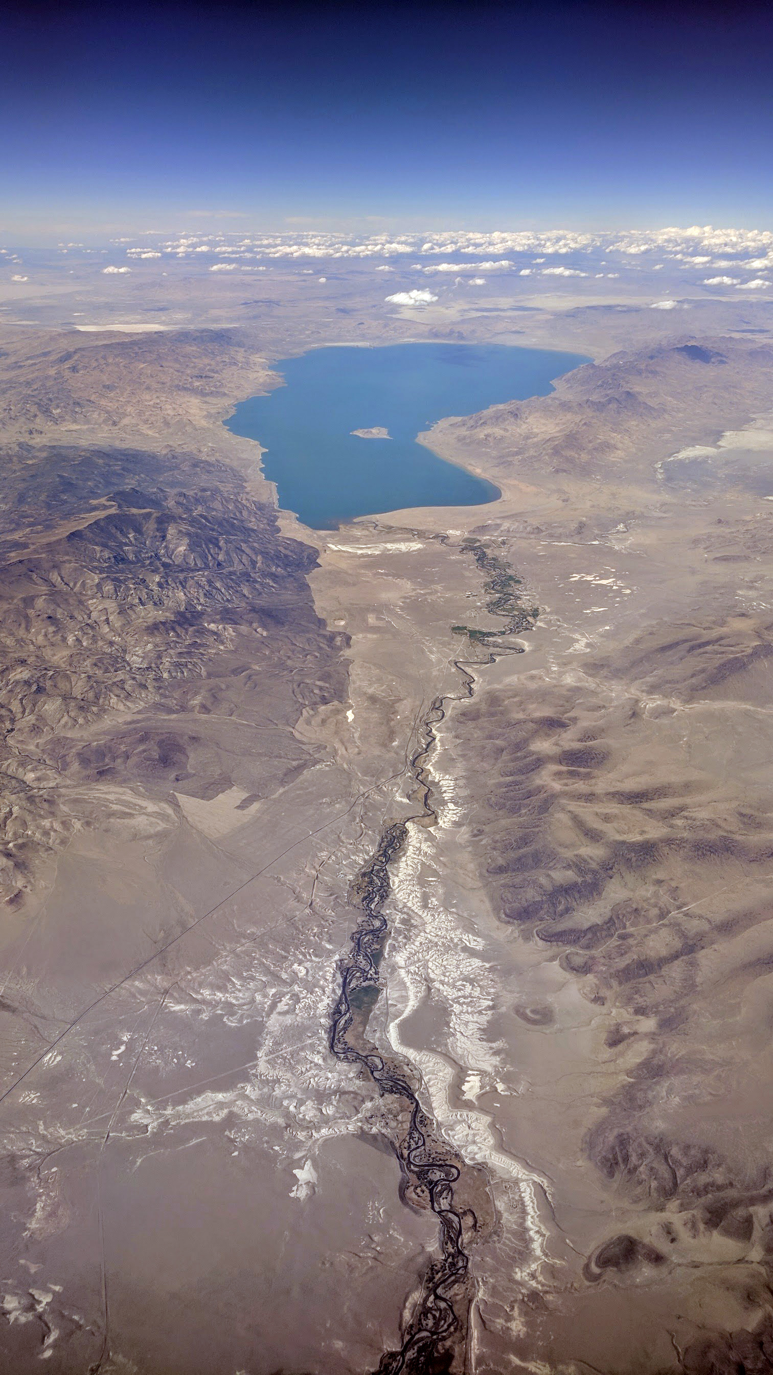
Pyramid Lake is the geographic sink of the basin of the Truckee River, northeast of Reno, Nevada, United States. Pyramid Lake is the biggest remnant of ancient Lake Lahontan, the colossal inland sea that once covered most of Nevada. It is approximately 15 miles long and 11 miles wide, covering 112,000 acres entirely enclosed within the Pyramid Lake Paiute Tribe Reservation. Pyramid Lake is fed by the Truckee River, which is mostly the outflow from Lake Tahoe. The Truckee River enters Pyramid Lake at its southern end. Pyramid Lake is an endorheic lake. It has no outlet, with water left only by evaporation, or sub-surface seepage. The lake has about 10% of the area of the Great Salt Lake, but it has about 25% more volume. The salinity is approximately 1/6 that of sea water. Although clear Lake Tahoe forms the headwaters that drain to Pyramid Lake, the Truckee River delivers more turbid waters to Pyramid Lake after traversing the steep Sierra terrain and collecting moderately hi ... [...More Info...] [...Related Items...] OR: [Wikipedia] [Google] [Baidu] |
Las Vegas Valley (landform)
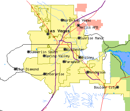
The Las Vegas Valley is a major metropolitan area in the southern part of the U.S. state of Nevada, and the second largest in the Southwestern United States. The state's largest urban agglomeration, the Las Vegas Metropolitan Statistical Area is coextensive since 2003 with Clark County, Nevada. The Valley is largely defined by the Las Vegas Valley landform, a basin area surrounded by mountains to the north, south, east and west of the metropolitan area. The Valley is home to the three largest incorporated cities in Nevada: Las Vegas, Henderson and North Las Vegas. Eleven unincorporated towns governed by the Clark County government are part of the Las Vegas Township and constitute the largest community in the state of Nevada. The names Las Vegas and Vegas are interchangeably used to indicate the Valley, the Strip, and the city, and as a brand by the Las Vegas Convention and Visitors Authority to denominate the region. The Valley is affectionately known as the "ninth island" ... [...More Info...] [...Related Items...] OR: [Wikipedia] [Google] [Baidu] |
Köppen Climate Types Nevada
Köppen is a German surname. Notable people with the surname include: * Bernd Köppen (born 1951), German pianist and composer * Carl Köppen (1833-1907), German military advisor in Meiji era Japan * Edlef Köppen (1893–1939), German author and radio editor * Friedrich Köppen (1775–1858), German philosopher * Jan Köppen (born 1983), German television presenter and DJ * Jens Köppen (born 1966), German rower * Karl Friedrich Köppen (1808–1863), German teacher and political journalist * Kerstin Köppen (born 1967), German rower * Wladimir Köppen (1846–1940), German geographer, meteorologist, climatologist and botanist who developed the Köppen climate classification ** Köppen climate classification, developed by Wladimir Köppen See also * Lene Køppen (born 1953), Danish badminton player * Koeppen * Koppen Koppen is a surname. Notable people with the surname include: * Dan Koppen (born 1979), American football offensive lineman * Erwin Koppen (1929–1990), German lit ... [...More Info...] [...Related Items...] OR: [Wikipedia] [Google] [Baidu] |
Spring Mountains
The Spring Mountains are a mountain range of Southern Nevada in the United States, running generally northwest–southeast along the west side of Las Vegas and south to the border with California. Most land in the mountains is owned by the United States Forest Service and the Bureau of Land Management and managed as the Spring Mountains National Recreation Area within the Humboldt-Toiyabe National Forest and the Red Rock Canyon National Conservation Area. Geography The Spring Mountains range is named for the number of springs to be found, many of them in the recesses of Red Rock Canyon National Conservation Area, which is on the eastern side of the mountains. The Spring Mountains divide the Pahrump Valley and Amargosa River basins from the Las Vegas Valley watershed, which drains into the Colorado River watershed, by way of Las Vegas Wash into Lake Mead, thus the mountains define part of the boundary of the Great Basin. The Great Basin Divide, (one of the Great Basin region b ... [...More Info...] [...Related Items...] OR: [Wikipedia] [Google] [Baidu] |
Lake Tahoe
Lake Tahoe (; was, Dáʔaw, meaning "the lake") is a Fresh water, freshwater lake in the Sierra Nevada (U.S.), Sierra Nevada of the United States. Lying at , it straddles the state line between California and Nevada, west of Carson City, Nevada, Carson City. Lake Tahoe is the largest alpine lake in North America, and at it trails only the five Great Lakes as the List of lakes by volume, largest by volume in the United States. Its depth is , making it the List of lakes by depth, second deepest in the United States after Crater Lake in Oregon (). The lake was formed about two million years ago as part of the Lake Tahoe Basin, and its modern extent was shaped during the Quaternary glaciation, ice ages. It is known for the clarity of its water and the panorama of surrounding mountains on all sides. The area surrounding the lake is also referred to as Lake Tahoe, or simply Tahoe. More than 75% of the lake's Drainage basin, watershed is United States National Forest, national forest ... [...More Info...] [...Related Items...] OR: [Wikipedia] [Google] [Baidu] |
Border
Borders are usually defined as geographical boundaries, imposed either by features such as oceans and terrain, or by political entities such as governments, sovereign states, federated states, and other subnational entities. Political borders can be established through warfare, colonization, or mutual agreements between the political entities that reside in those areas; the creation of these agreements is called boundary delimitation. Some borders—such as most states' internal administrative borders, or inter-state borders within the Schengen Area—are open and completely unguarded. Most external political borders are partially or fully controlled, and may be crossed legally only at designated border checkpoints; adjacent border zones may also be controlled. Buffer zones may be setup on borders between belligerent entities to lower the risk of escalation. While ''border'' refers to the boundary itself, the area around the border is called the frontier. History In the ... [...More Info...] [...Related Items...] OR: [Wikipedia] [Google] [Baidu] |
Line (geometry)
In geometry, a line is an infinitely long object with no width, depth, or curvature. Thus, lines are one-dimensional objects, though they may exist in two, three, or higher dimension spaces. The word ''line'' may also refer to a line segment in everyday life, which has two points to denote its ends. Lines can be referred by two points that lay on it (e.g., \overleftrightarrow) or by a single letter (e.g., \ell). Euclid described a line as "breadthless length" which "lies evenly with respect to the points on itself"; he introduced several postulates as basic unprovable properties from which he constructed all of geometry, which is now called Euclidean geometry to avoid confusion with other geometries which have been introduced since the end of the 19th century (such as non-Euclidean, projective and affine geometry). In modern mathematics, given the multitude of geometries, the concept of a line is closely tied to the way the geometry is described. For instance, in analytic ... [...More Info...] [...Related Items...] OR: [Wikipedia] [Google] [Baidu] |
Mojave Desert
The Mojave Desert ( ; mov, Hayikwiir Mat'aar; es, Desierto de Mojave) is a desert in the rain shadow of the Sierra Nevada mountains in the Southwestern United States. It is named for the indigenous Mojave people. It is located primarily in southeastern California and southwestern Nevada, with small portions extending into Arizona and Utah. The Mojave Desert, together with the Sonoran, Chihuahuan, and Great Basin deserts, forms a larger North American Desert. Of these, the Mojave is the smallest and driest. The Mojave Desert displays typical basin and range topography, generally having a pattern of a series of parallel mountain ranges and valleys. It is also the site of Death Valley, which is the lowest elevation in North America. The Mojave Desert is often colloquially called the "high desert", as most of it lies between . It supports a diversity of flora and fauna. The desert supports a number of human activities, including recreation, ranching, and military training. ... [...More Info...] [...Related Items...] OR: [Wikipedia] [Google] [Baidu] |
Sky Island
Sky islands are topographic isolation, isolated mountains surrounded by radically different lowland environments. The term originally referred to those found on the Mexican Plateau, and has extended to similarly isolated montane ecosystems, high-elevation forests. The isolation has significant implications for these natural habitats. The Southwestern United States, American Southwest region began warming up between and 10,000 years Before Present, BP and atmospheric temperatures increased substantially, resulting in the formation of vast deserts that isolated the sky islands. Endemism, altitudinal migration, and Relict (biology), relict populations are some of the natural phenomena to be found on sky islands. The complex dynamics of species richness on sky islands draws attention from the discipline of biogeography, and likewise the biodiversity is of concern to conservation biology. One of the key elements of a sky island is separation by physical distance from the other ... [...More Info...] [...Related Items...] OR: [Wikipedia] [Google] [Baidu] |
Arizona
Arizona ( ; nv, Hoozdo Hahoodzo ; ood, Alĭ ṣonak ) is a state in the Southwestern United States. It is the 6th largest and the 14th most populous of the 50 states. Its capital and largest city is Phoenix. Arizona is part of the Four Corners region with Utah to the north, Colorado to the northeast, and New Mexico to the east; its other neighboring states are Nevada to the northwest, California to the west and the Mexican states of Sonora and Baja California to the south and southwest. Arizona is the 48th state and last of the contiguous states to be admitted to the Union, achieving statehood on February 14, 1912. Historically part of the territory of in New Spain, it became part of independent Mexico in 1821. After being defeated in the Mexican–American War, Mexico ceded much of this territory to the United States in 1848. The southernmost portion of the state was acquired in 1853 through the Gadsden Purchase. Southern Arizona is known for its desert cl ... [...More Info...] [...Related Items...] OR: [Wikipedia] [Google] [Baidu] |


