|
GeoMod
GeoMod is a raster-based land change modeling tool in the GIS software TerrSet that simulates the gain or the loss of a land category over a specified time interval.Pontius, R. G., Cornell, J. D., & Hall, C. A. (2001). Modeling the spatial pattern of land-use change with GEOMOD2: application and validation for Costa Rica. ''Agriculture, Ecosystems & Environment'', ''85''(1), 191-203. The model only simulates the spatial allocation of change between two land categories either forwards or backwards in time.Pontius Jr, R. G., & Chen, H. (2006). GEOMOD modeling. ''Clark University''. Simulation inputs GeoMod simulates land change based on a combination of several input requirements. First, users must specify the beginning (time 1) and end time (time 2) for the temporal extent of the simulation and must identify a time step for the simulation. The model also needs the image that depicts the two land categories (e.g. category 1= undeveloped and category 2=developed) at time and a projec ... [...More Info...] [...Related Items...] OR: [Wikipedia] [Google] [Baidu] |
Land Change Modeling
Land change models (LCMs) describe, project, and explain changes in and the dynamics of land use and land-cover. LCMs are a means of understanding ways that humans change the Earth's surface in the past, present, and future. Land change models are valuable in development policy, helping guide more appropriate decisions for resource management and the natural environment at a variety of scales ranging from a small piece of land to the entire spatial extent. Moreover, developments within land-cover, environmental and socio-economic data (as well as within technological infrastructures) have increased opportunities for land change modeling to help support and influence decisions that affect human-environment systems, as national and international attention increasingly focuses on issues of global climate change and sustainability. Importance Changes in land systems have consequences for climate and environmental change on every scale. Therefore, decisions and policies in rela ... [...More Info...] [...Related Items...] OR: [Wikipedia] [Google] [Baidu] |
TerrSet
TerrSet (formerly IDRISI) is an integrated geographic information system (GIS) and remote sensing software developed by Clark Labs at Clark University for the analysis and display of digital geospatial information. TerrSet is a PC grid-based system that offers tools for researchers and scientists engaged in analyzing earth system dynamics for effective and responsible decision making for environmental management, sustainable resource development and equitable resource allocation. Key features of TerrSet include: * GIS analytical tools for basic and advanced spatial analysis, including tools for surface and statistical analysis, decision support, land change and prediction, and image time series analysis; * an image processing system with multiple hard and soft classifiers, including machine learning classifiers such as neural networks and classification tree analysis, as well as image segmentation for classification; * Land Change Modeler, a land planning and decision support tool ... [...More Info...] [...Related Items...] OR: [Wikipedia] [Google] [Baidu] |
Raster Graphics
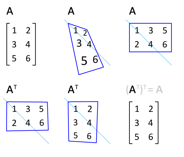
upright=1, The Smiley, smiley face in the top left corner is a raster image. When enlarged, individual pixels appear as squares. Enlarging further, each pixel can be analyzed, with their colors constructed through combination of the values for red, green and blue. In computer graphics and digital photography, a raster graphic represents a two-dimensional picture as a rectangular matrix or grid of square pixels, viewable via a computer display, paper, or other display medium. A raster is technically characterized by the width and height of the image in pixels and by the number of bits per pixel. Raster images are stored in image files with varying dissemination, production, generation, and acquisition formats. The printing and prepress industries know raster graphics as contones (from ''continuous tones''). In contrast, line art is usually implemented as vector graphics in digital systems. Many raster manipulations map directly onto the mathematical formalisms of linear al ... [...More Info...] [...Related Items...] OR: [Wikipedia] [Google] [Baidu] |
Geographic Information System
A geographic information system (GIS) is a type of database containing Geographic data and information, geographic data (that is, descriptions of phenomena for which location is relevant), combined with Geographic information system software, software tools for managing, Spatial analysis, analyzing, and Cartographic design, visualizing those data. In a broader sense, one may consider such a system to also include human users and support staff, procedures and workflows, body of knowledge of relevant concepts and methods, and institutional organizations. The uncounted plural, ''geographic information systems'', also abbreviated GIS, is the most common term for the industry and profession concerned with these systems. It is roughly synonymous with geoinformatics and part of the broader geospatial field, which also includes GPS, remote sensing, etc. Geographic information science, the academic discipline that studies these systems and their underlying geographic principles, may also ... [...More Info...] [...Related Items...] OR: [Wikipedia] [Google] [Baidu] |
Reducing Emissions From Deforestation And Forest Degradation
Reduction, reduced, or reduce may refer to: Science and technology Chemistry * Reduction (chemistry), part of a reduction-oxidation (redox) reaction in which atoms have their oxidation state changed. ** Organic redox reaction, a redox reaction that takes place with organic compounds ** Ore reduction: see smelting Computing and algorithms * Reduction (complexity), a transformation of one problem into another problem * Reduction (recursion theory), given sets A and B of natural numbers, is it possible to effectively convert a method for deciding membership in B into a method for deciding membership in A? * Bit Rate Reduction, an audio compression method * Data reduction, simplifying data in order to facilitate analysis * Graph reduction, an efficient version of non-strict evaluation * L-reduction, a transformation of optimization problems which keeps the approximability features * Partial order reduction, a technique for reducing the size of the state-space to be searched b ... [...More Info...] [...Related Items...] OR: [Wikipedia] [Google] [Baidu] |


