|
General Pierce Bridge
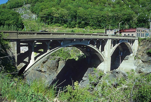
The General Pierce Bridge is a steel truss road bridge over the Connecticut River between Greenfield, Massachusetts and Montague, Massachusetts carrying Montague City Road. As of summer 2021, the bridge is closed to vehicle traffic while undergoing major repairs. It remains open for foot traffic. It is scheduled to fully reopen in summer 2024. Previous structures The current bridge was preceded at that location by two bridges destroyed in the Flood of 1936. Upstream was the wooden double-decked covered bridge known as the Montague City Bridge, and carried rail traffic on top, with other traffic below. It was built in 1866, and was over long, with 5 spans. Next was the trolley bridge, which was a metal through-truss. When the Flood of 1936 came, the trolley bridge was knocked off its piers and sunk into the river, where it remains. The covered rail bridge floated down the river, where it knocked two spans off the New York, New Haven and Hartford Railroad Bridge (now know ... [...More Info...] [...Related Items...] OR: [Wikipedia] [Google] [Baidu] |
Connecticut River
The Connecticut River is the longest river in the New England region of the United States, flowing roughly southward for through four states. It rises 300 yards (270 m) south of the U.S. border with Quebec, Canada, and discharges at Long Island Sound. Its watershed encompasses , covering parts of five U.S. states and one Canadian province, via 148 tributaries, 38 of which are major rivers. It produces 70% of Long Island Sound's fresh water, discharging at per second. The Connecticut River Valley is home to some of the northeastern United States' most productive farmland, as well as the Hartford–Springfield Knowledge Corridor, a metropolitan region of approximately two million people surrounding Springfield, Massachusetts, and Hartford, Connecticut. History The word "Connecticut" is a corruption of the Mohegan word ''quinetucket'', which means "beside the long, tidal river". The word came into English during the early 1600s to name the river, which was also called simply "Th ... [...More Info...] [...Related Items...] OR: [Wikipedia] [Google] [Baidu] |
Greenfield, Massachusetts
Greenfield is a city in and the county seat of Franklin County, Massachusetts, United States. Greenfield was first settled in 1686. The population was 17,768 at the 2020 census. Greenfield is home to Greenfield Community College, the Pioneer Valley Symphony Orchestra, and the Franklin County Fair. The city has a Main Street Historic District containing fine examples of Federal, Greek Revival, and Victorian architecture. Greenfield is part of the Springfield, Massachusetts, Metropolitan Statistical Area. History Pocumtuck Indians first settled and originally inhabited the Greenfield area. Native American artifacts found in the area have been dated between 7,000 and 9,000 years BCE. The Pocumtucks planted field crops and fished local rivers. Some sources claim that they were wiped out by the Mohawks in 1664 and that the land was left unoccupied. Other sources show that the Pocumtucks joined the Wampanoag chief Metacom in August 1675 in the fight against English encroachment, ... [...More Info...] [...Related Items...] OR: [Wikipedia] [Google] [Baidu] |
Montague, Massachusetts
Montague is a town in Franklin County, Massachusetts, United States. The population was 8,580 at the 2020 census. It is part of the Springfield, Massachusetts metropolitan statistical area. The villages of Montague Center, Montague City, Lake Pleasant, Millers Falls, and Turners Falls are located in the town of Montague; Turners Falls, comprising over half the population of the town and its main business district, is sometimes used as a metonym for the entire town of Montague. History Originally inhabited by the Pocomtuc tribe, the area was known as ''Peskeompskut''. Montague was first settled by Europeans in 1715 and was incorporated in 1754. The town has five villages within it: Montague Center, Montague City, Turners Falls, Millers Falls, and Lake Pleasant. Montague Center was the original European settlement and was originally a part of the town of Sunderland. Lake Pleasant was a prominent spiritualist campground. Turners Falls was a planned mill community (similar to ... [...More Info...] [...Related Items...] OR: [Wikipedia] [Google] [Baidu] |
MassHighway
The Massachusetts Highway Department (abbreviated MassHighway) was the highway department in the U.S. state of Massachusetts from 1991 until the formation of the Massachusetts Department of Transportation (MassDOT) in 2009. The responsibilities of MassHighway included the design, construction and maintenance of all state highways and bridges and signage of numbered routes. During that time it was a part of the Massachusetts Executive Office of Transportation (EOT), which was also reorganized into the Department of Transportation. As part of the reorganization, the separate Massachusetts Turnpike Authority was dissolved and its duties assumed by the MassDOT highway division. The department was split into five district offices managed by a District Highway Director (DHD) under the supervision of the Chief Engineer at MassHighway headquarters in Boston. This district plan has been continued under MassDOT and the Boston area (westward along the Mass Turnpike to Weston and south throu ... [...More Info...] [...Related Items...] OR: [Wikipedia] [Google] [Baidu] |
Truss Bridge
A truss bridge is a bridge whose load-bearing superstructure is composed of a truss, a structure of connected elements, usually forming triangular units. The connected elements (typically straight) may be stressed from tension, compression, or sometimes both in response to dynamic loads. The basic types of truss bridges shown in this article have simple designs which could be easily analyzed by 19th and early 20th-century engineers. A truss bridge is economical to construct because it uses materials efficiently. Design The nature of a truss allows the analysis of its structure using a few assumptions and the application of Newton's laws of motion according to the branch of physics known as statics. For purposes of analysis, trusses are assumed to be pin jointed where the straight components meet, meaning that taken alone, every joint on the structure is functionally considered to be a flexible joint as opposed to a rigid joint with strength to maintain its own shape, and th ... [...More Info...] [...Related Items...] OR: [Wikipedia] [Google] [Baidu] |
IMG 3949-Montague-City-Road-bridge-between-spans
img or IMG is an abbreviation for image. img or IMG may also refer to: * IMG (company), global sports and media business headquartered in New York City but with its main offices in Cleveland, originally known as the "International Management Group", with divisions including: ** IMG Academy, an athletic training complex in Bradenton, Florida with facilities for multiple sports ** IMG Artists, a performing arts management company with multiple worldwide offices ** IMG College, a college sports marketing agency based in Winston-Salem, North Carolina ** IMG Models, a modeling agency based in New York * IMG (file format), the file extension of several different disk image formats which store a full digital representation (image) of disk drive or storage media * IMG, a prefix for camera image file names commonly used in Design rule for Camera File system * mg/code>, a tag used in BBCode to place an image * , an HTML element used to place an image; see * IMG Worlds of Adventure, the larg ... [...More Info...] [...Related Items...] OR: [Wikipedia] [Google] [Baidu] |
Springfield, Massachusetts
Springfield is a city in the Commonwealth of Massachusetts, United States, and the seat of Hampden County. Springfield sits on the eastern bank of the Connecticut River near its confluence with three rivers: the western Westfield River, the eastern Chicopee River, and the eastern Mill River. At the 2020 census, the city's population was 155,929, making it the third-largest city in Massachusetts, the fourth-most populous city in New England after Boston, Worcester, and Providence, and the 12th-most populous in the Northeastern United States. Metropolitan Springfield, as one of two metropolitan areas in Massachusetts (the other being Greater Boston), had a population of 699,162 in 2020. Springfield was founded in 1636, the first Springfield in the New World. In the late 1700s, during the American Revolution, Springfield was designated by George Washington as the site of the Springfield Armory because of its central location. Subsequently it was the site of Shays' Rebellio ... [...More Info...] [...Related Items...] OR: [Wikipedia] [Google] [Baidu] |
Canalside Rail Trail Bridge
The Canalside Rail Trail Bridge (also known as the New York, New Haven and Hartford Railroad (Turners Falls Branch) Bridge) is a former New York, New Haven and Hartford Railroad (Turner Falls Branch) rail bridge across the Connecticut River between Deerfield and Montague, Massachusetts. The bridge (Massachusetts numbers: D06033/M28019) is on the Massachusetts Historic Bridge Inventory as a "Historic Metal Truss Bridge", currently the sixth oldest metal truss bridge on the state-wide historic registry. The Canalside Rail Trail, completed in Spring 2008, incorporates this bridge. History and construction of the bridge Originally built in 1880 by Keystone Bridge Co., Pittsburgh, Pennsylvania, two of its three spans were knocked off their piers by the floating Montague City Covered Bridge during the 1936 flood. Subsequently, those spans were rebuilt and replaced in 1936 by the Phoenix Bridge Company, Phoenixville, Pennsylvania. The remaining span of the original bridge is the ... [...More Info...] [...Related Items...] OR: [Wikipedia] [Google] [Baidu] |
Sunderland Bridge (Massachusetts)
The Sunderland Bridge is a crossing over the Connecticut River in western Massachusetts, connecting the towns of South Deerfield and Sunderland, carrying Massachusetts Route 116. History and construction of the bridge There was at least one preceding bridge at this location, a metal through-truss bridge destroyed by the floating Montague City Covered Bridge during the Flood of 1936. The current Sunderland Bridge is a deck truss bridge completed in 1937. Reconstruction of the bridge was completed in 1994. Replacement of the original art deco railings by modern ones was controversial. References See also *List of crossings of the Connecticut River This is a list of bridges and other crossings of the Connecticut River from its mouth at Long Island Sound upstream to its source at the Connecticut Lakes. The list includes current road and rail crossings, as well as ferries carrying a state high ... Truss bridges in the United States Bridges over the Connecticut River ... [...More Info...] [...Related Items...] OR: [Wikipedia] [Google] [Baidu] |
List Of Crossings Of The Connecticut River ...
This is a list of bridges and other crossings of the Connecticut River from its mouth at Long Island Sound upstream to its source at the Connecticut Lakes. The list includes current road and rail crossings, as well as ferries carrying a state highway across the river. Some pedestrian bridges and abandoned bridges are also listed. Crossings Source: Fourth Connecticut Lake () See also * List of populated places on the Connecticut River References Further reading * External links {{GeoGroupTemplate * Bridges in Connecticut Bridges in Massachusetts Bridges in New Hampshire Connecticut River Connecticut River The Connecticut River is the longest river in the New England region of the United States, flowing roughly southward for through four states. It rises 300 yards (270 m) south of the U.S. border with Quebec, Canada, and discharges at Long Island ... [...More Info...] [...Related Items...] OR: [Wikipedia] [Google] [Baidu] |


