|
Gatbawi (Mokpo)
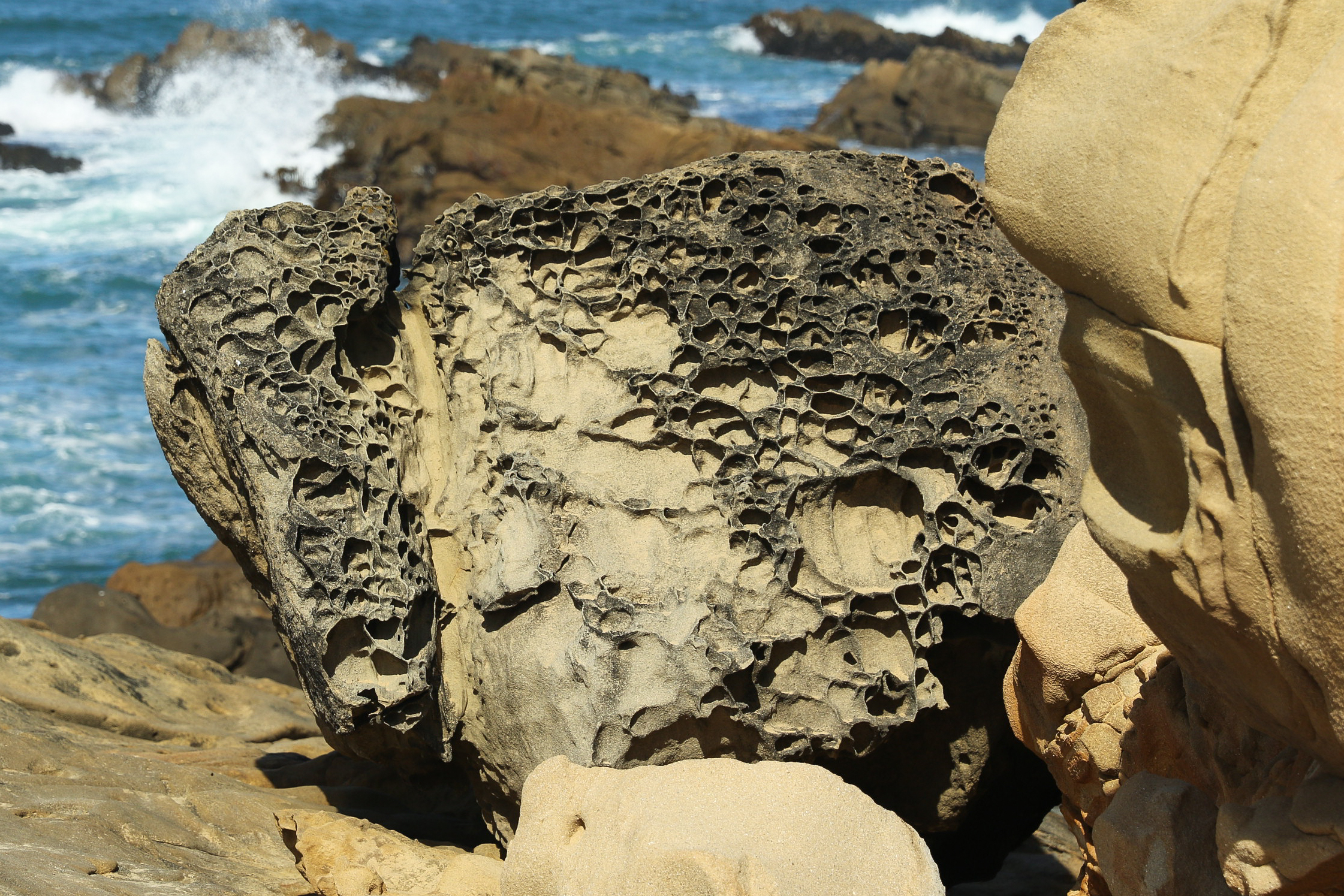
Gatbawi, is a natural Sandstone and Tafoni formation found on the shore of Mokpo's east harbor, near the mouth of the Yeongsan River, South Jeolla Province, South Korea. Name The name of this formation, Gatbawi ( gat is a hat, bawi is a rock), means a rock shaped like a hat, specifically, a traditional Korean costume item worn like a hat resembling a Satgat, or a traditional Korean conical bamboo rain hat. The two individual formations are named Jeongbawi and Satgatbawi, also the larger rock is called the "father" and the smaller one is called the "son". Geology Gatbawi is a natural tafoni (small cave-like features found in granular rock such as sandstone, with rounded entrances and smooth concave walls) formation between 6–8 meters/20–26 feet in size. Legends There are two folk legend A legend is a Folklore genre, genre of folklore that consists of a narrative featuring human actions, believed or perceived, both by teller and listeners, to have taken place in human h ... [...More Info...] [...Related Items...] OR: [Wikipedia] [Google] [Baidu] |
Sandstone
Sandstone is a clastic sedimentary rock composed mainly of sand-sized (0.0625 to 2 mm) silicate grains. Sandstones comprise about 20–25% of all sedimentary rocks. Most sandstone is composed of quartz or feldspar (both silicates) because they are the most resistant minerals to weathering processes at the Earth's surface. Like uncemented sand, sandstone may be any color due to impurities within the minerals, but the most common colors are tan, brown, yellow, red, grey, pink, white, and black. Since sandstone beds often form highly visible cliffs and other topographic features, certain colors of sandstone have been strongly identified with certain regions. Rock formations that are primarily composed of sandstone usually allow the percolation of water and other fluids and are porous enough to store large quantities, making them valuable aquifers and petroleum reservoirs. Quartz-bearing sandstone can be changed into quartzite through metamorphism, usually related to ... [...More Info...] [...Related Items...] OR: [Wikipedia] [Google] [Baidu] |
Tafoni
Although various definitions can be found in the scientific literature, tafoni (singular: tafone) are commonly defined as small (less than ) to large (greater than ) cavity features that develop in either natural or manmade, vertical to steeply sloping, exposures of granular rock (i.e., granite, sandstone) with smooth concave walls, and often round rims and openings. Recognized subcategories of tafoni include ''honeycomb'', ''stonelace'', ''alveolar'' (less than ), ''sidewall'', ''basal'', ''nested'', and ''relic tafoni''. It is also commonly synonymous with ''nido d’ape roccioso'' in Italian.Paradise, T.R., 2013. ''Tafoni and other rock basins.'' In: Shroder, J. (Editor in Chief), Pope, G.A., (Ed.), ''Treatise on Geomorphology.'' Academic Press, San Diego, CA, vol. 4, Weathering and Soils Geomorphology, pp.111–126. The etymology of the word ''tafoni'' is unclear. Tafoni may come from the Greek word ''taphos'', ''tomb'', or it may stem from a Corsican or Sicilian word for '' ... [...More Info...] [...Related Items...] OR: [Wikipedia] [Google] [Baidu] |
Mokpo
Mokpo (; ''Mokpo-si'') is a city in South Jeolla Province, South Korea, located at the southwestern tip of the Korean Peninsula, close to Yudal mountain. Mokpo has frequent high-speed train services to Seoul, and is the terminus for a number of ferry routes serving islands in the adjacent Yellow Sea and Dadohae National Maritime Park. During the Japanese Occupation (1910–1945), Mokpo served as a crucial port for both commercial ventures and public transportation, due to its location along the sea routes between the Japanese archipelago and the Chinese mainland. The large number of islands surrounding Mokpo have also served as a protective barrier, making the city less vulnerable to high tides and tsunamis. In the occupation era, large residential areas were built to accommodate the Japanese colonists, which are now the city's historic districts. The end of World War II and Korea's independence in 1945 were responsible for the city slowly losing its position as a host to major g ... [...More Info...] [...Related Items...] OR: [Wikipedia] [Google] [Baidu] |
Yeongsan River
The Yeongsangang River is a river in south-western South Korea. It has a length of 129.50 km, and covers an area of 3,467.83 km2. It runs through Damyang, Naju, Gwangju and other regions and eventually flows into the Yellow Sea at Yeongam through the estuary bank. See also *Rivers of Korea The Korean peninsula is mainly mountainous along its east coast, so most of its river water flows west, emptying into the Yellow Sea. Some of these rivers flow through lakes en route to the coast, but these are all artificial reservoirs, as ther ... * Geography of South Korea Notes References External links A paper describing the effects of the damming efforts of the late 1970s and 1980s Rivers of South Jeolla Province Rivers of Gwangju Naju Yeongam County Mokpo Damyang County {{SouthKorea-river-stub ... [...More Info...] [...Related Items...] OR: [Wikipedia] [Google] [Baidu] |
South Jeolla Province
South Jeolla Province (; ''Jeollanam-do''; ), also known as Jeonnam, is a province of South Korea. South Jeolla has a population of 1,902,324 (2014) and has a geographic area of located in the Honam region at the southwestern tip of the Korean Peninsula. South Jeolla borders the provinces of North Jeolla to the north, South Gyeongsang to the northeast, and Jeju to the southwest in the Korea Strait. Muan County is the capital and Yeosu is the largest city of South Jeolla, with other major cities including Suncheon, Mokpo, and Gwangyang. Gwangju was the largest city of South Jeolla until becoming a Metropolitan City in 1986, and was the historic capital until the provincial government was relocated to the Muan County town of Namak in 2005. South Jeolla was established in 1896 from the province of Jeolla, one of the Eight Provinces of Korea, consisting of the southern half of its mainland territory and most outlying islands. Geography The province is part of the Honam region, a ... [...More Info...] [...Related Items...] OR: [Wikipedia] [Google] [Baidu] |
South Korea
South Korea, officially the Republic of Korea (ROK), is a country in East Asia, constituting the southern part of the Korea, Korean Peninsula and sharing a Korean Demilitarized Zone, land border with North Korea. Its western border is formed by the Yellow Sea, while its eastern border is defined by the Sea of Japan. South Korea claims to be the sole legitimate government of the entire peninsula and List of islands of South Korea, adjacent islands. It has a Demographics of South Korea, population of 51.75 million, of which roughly half live in the Seoul Capital Area, the List of metropolitan areas by population, fourth most populous metropolitan area in the world. Other major cities include Incheon, Busan, and Daegu. The Korean Peninsula was inhabited as early as the Lower Paleolithic period. Its Gojoseon, first kingdom was noted in Chinese records in the early 7th century BCE. Following the unification of the Three Kingdoms of Korea into Unified Silla, Silla and Balhae in the ... [...More Info...] [...Related Items...] OR: [Wikipedia] [Google] [Baidu] |
Gat (hat)
A ''gat'' ( ) is a Korean traditional hat worn by men along with ''hanbok'' (Korean traditional clothing) during the Joseon period. It is made from horsehair with a bamboo frame and is partly transparent. Most ''gat'' are cylindrical in shape with a wide brim on a bamboo frame. Before the late 19th century, only noble class men could wear ''gat'', which represented their social status and protected their topknots (). Artisans who make ''gat'' are called ''ganniljang'' (), from ''gannil'' (, a compound of two words ''gat'' and ''il'' (work); "''gat'' making") + ''jang'' ( "artisan, craftsperson, master of a craft"). As ''gannil'' requires artisanship throughout a complex series of techniques involving an array of materials, it has been designated as Intangible Cultural Property No. 4 on December 24, 1964. History The origins of ''gat'' date back to ancient times. Usually, the following hats are considered to be the first specimens of what is known as gat today: the so-called ''i ... [...More Info...] [...Related Items...] OR: [Wikipedia] [Google] [Baidu] |
Conical Asian Hat
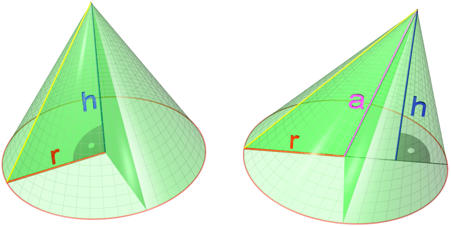
A cone is a three-dimensional geometric shape that tapers smoothly from a flat base (frequently, though not necessarily, circular) to a point called the apex or vertex. A cone is formed by a set of line segments, half-lines, or lines connecting a common point, the apex, to all of the points on a base that is in a plane that does not contain the apex. Depending on the author, the base may be restricted to be a circle, any one-dimensional quadratic form in the plane, any closed one-dimensional figure, or any of the above plus all the enclosed points. If the enclosed points are included in the base, the cone is a solid object; otherwise it is a two-dimensional object in three-dimensional space. In the case of a solid object, the boundary formed by these lines or partial lines is called the ''lateral surface''; if the lateral surface is unbounded, it is a conical surface. In the case of line segments, the cone does not extend beyond the base, while in the case of half-li ... [...More Info...] [...Related Items...] OR: [Wikipedia] [Google] [Baidu] |
Legend
A legend is a Folklore genre, genre of folklore that consists of a narrative featuring human actions, believed or perceived, both by teller and listeners, to have taken place in human history. Narratives in this genre may demonstrate human values, and possess certain qualities that give the tale verisimilitude (literature), verisimilitude. Legend, for its active and passive participants may include miracles. Legends may be transformed over time to keep them fresh and vital. Many legends operate within the realm of uncertainty, never being entirely believed by the participants, but also never being resolutely doubted. Legends are sometimes distinguished from myths in that they concern human beings as the main characters rather than gods, and sometimes in that they have some sort of historical basis whereas myths generally do not. The Brothers Grimm defined ''legend'' as "Folklore, folktale historically grounded". A by-product of the "concern with human beings" is the long list o ... [...More Info...] [...Related Items...] OR: [Wikipedia] [Google] [Baidu] |
Landforms Of South Jeolla Province
A landform is a natural or anthropogenic land feature on the solid surface of the Earth or other planetary body. Landforms together make up a given terrain, and their arrangement in the landscape is known as topography. Landforms include hills, mountains, canyons, and valleys, as well as shoreline features such as bays, peninsulas, and seas, including submerged features such as mid-ocean ridges, volcanoes, and the great ocean basins. Physical characteristics Landforms are categorized by characteristic physical attributes such as elevation, slope, orientation, stratification, rock exposure and soil type. Gross physical features or landforms include intuitive elements such as berms, mounds, hills, ridges, cliffs, valleys, rivers, peninsulas, volcanoes, and numerous other structural and size-scaled (e.g. ponds vs. lakes, hills vs. mountains) elements including various kinds of inland and oceanic waterbodies and sub-surface features. Mountains, hills, plateaux, and plains are the fou ... [...More Info...] [...Related Items...] OR: [Wikipedia] [Google] [Baidu] |
Tourist Attractions In South Jeolla Province
Tourism is travel for pleasure or business; also the theory and practice of touring (other), touring, the business of attracting, accommodating, and entertaining tourists, and the business of operating tour (other), tours. The World Tourism Organization defines tourism more generally, in terms which go "beyond the common perception of tourism as being limited to holiday activity only", as people "travelling to and staying in places outside their usual environment for not more than one consecutive year for leisure and not less than 24 hours, business and other purposes". Tourism can be Domestic tourism, domestic (within the traveller's own country) or International tourism, international, and international tourism has both incoming and outgoing implications on a country's balance of payments. Tourism numbers declined as a result of a strong economic slowdown (the late-2000s recession) between the second half of 2008 and the end of 2009, and in consequence of t ... [...More Info...] [...Related Items...] OR: [Wikipedia] [Google] [Baidu] |
Landforms Of South Korea
A landform is a natural or anthropogenic land feature on the solid surface of the Earth or other planetary body. Landforms together make up a given terrain, and their arrangement in the landscape is known as topography. Landforms include hills, mountains, canyons, and valleys, as well as shoreline features such as bays, peninsulas, and seas, including submerged features such as mid-ocean ridges, volcanoes, and the great ocean basins. Physical characteristics Landforms are categorized by characteristic physical attributes such as elevation, slope, orientation, stratification, rock exposure and soil type. Gross physical features or landforms include intuitive elements such as berms, mounds, hills, ridges, cliffs, valleys, rivers, peninsulas, volcanoes, and numerous other structural and size-scaled (e.g. ponds vs. lakes, hills vs. mountains) elements including various kinds of inland and oceanic waterbodies and sub-surface features. Mountains, hills, plateaux, and plains are the fou ... [...More Info...] [...Related Items...] OR: [Wikipedia] [Google] [Baidu] |
Saunders_Quarry-1.jpg)


.jpg)
