|
Gassen Singaron
Gassen ( en, The Gander) is the westernmost of the large islets in Menkeøyane, part of Thousand Islands, a Norwegian archipelago south of Edgeøya. References * Norwegian Polar InstitutPlace Names of Svalbard Database Islands of Svalbard {{svalbard-geo-stub ... [...More Info...] [...Related Items...] OR: [Wikipedia] [Google] [Baidu] |
Menkeøyane
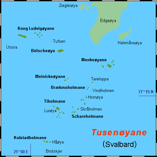
Menkeøyane ( en, Menke Islands) is a small Norwegian island group south of Halvmåneøya, an island off the southeast coast of Edgeøya. The group includes Havella, Alka, Gassen, Teisten, Islomen and Blåmåken. They comprise part of Thousand Islands. The islands are named after the German cartographer and historical geographer Heinrich Theodor Menke Heinrich Theodor Menke (24 May 1819 – 14 May 1892) was a German geographer, who was born and lived in Bremen. He is remembered for his work in historical geography. Menke studied theology and philology at the University of Bonn, and in 1842 rec ... (1819–92). The islands appear on the Muscovy Company's map (1625), one of which is labeled ''Heling I''. References * Norwegian Polar InstitutPlace Names of Svalbard Database*Purchas, S. 1625. Hakluytus Posthumus or Purchas His Pilgrimes: Contayning a History of the World in Sea Voyages and Lande Travells by Englishmen and others. Volumes XIII and XIV (Reprint 1906 J. Maclehose ... [...More Info...] [...Related Items...] OR: [Wikipedia] [Google] [Baidu] |
Thousand Islands (Svalbard)
Thousand IslandsDodd, G. J., G. P. Benson, & D. T. Watts. 1996. ''Arctic Pilot'', vol. 2. Taunton, UK: Hydrographer of the Navy, p. 225. ( no, Tusenøyane) is a group of small islands south of Edgeøya. They form part of the Svalbard archipelago. The group consists of over forty islands and islets, including Brotskjer, Kulstadholmane, Utsira, Tufsen, Kong Ludvigøyane, Bölscheøya, Hornøya, Tiholmane, Meinickeøyane, Sletteøya, Schareholmane, Skråholmen, Brækmoholmane, Tareloppa, Vindholmen, and Menkeøyane. History The Dutchman Joris Carolus was the first to distinctly mark a group of small islands south of Edgeøya. The Muscovy Company's map (1625) showed a vague mass of islands as well, some labeled, such as ''Wester I.'', ''Beare Iland'', ''Heling I.'', and the ''Hopeless Iles.'' (perhaps Kong Ludvigøyane). The cartographers Gerard Valck and Peter Schenk the Elder were the first to place a "great vague mass of islands stretching round the coast" south of ... [...More Info...] [...Related Items...] OR: [Wikipedia] [Google] [Baidu] |
Norway
Norway, officially the Kingdom of Norway, is a Nordic country in Northern Europe, the mainland territory of which comprises the western and northernmost portion of the Scandinavian Peninsula. The remote Arctic island of Jan Mayen and the archipelago of Svalbard also form part of Norway. Bouvet Island, located in the Subantarctic, is a dependency of Norway; it also lays claims to the Antarctic territories of Peter I Island and Queen Maud Land. The capital and largest city in Norway is Oslo. Norway has a total area of and had a population of 5,425,270 in January 2022. The country shares a long eastern border with Sweden at a length of . It is bordered by Finland and Russia to the northeast and the Skagerrak strait to the south, on the other side of which are Denmark and the United Kingdom. Norway has an extensive coastline, facing the North Atlantic Ocean and the Barents Sea. The maritime influence dominates Norway's climate, with mild lowland temperatures on the se ... [...More Info...] [...Related Items...] OR: [Wikipedia] [Google] [Baidu] |
Edgeøya
Edgeøya (), occasionally anglicised as Edge Island, is a Norwegian island located in southeast of the Svalbard archipelago; with an area of , it is the third-largest island in this archipelago. An Arctic island, it forms part of the Søraust-Svalbard Nature Reserve, home to polar bears and reindeer. An ice field covers its eastern side. The island takes its name from Thomas Edge (died 1624), an English merchant and whaler. It is seldom visited today and development of tourist facilities is forbidden by law because of its nature reserve status. History The history of Edgeøya's discovery has been a matter of dispute. Thomas Edge, writing in 1622, claimed the island was discovered by one of his ships in 1616. However, Joris Carolus, in a map published in 1614 and allegedly based on discoveries made by him the same year, shows what appears to be Edgeøya's south coast. Carolus showed the coastline split into two parts: "Onbekende Cust" (meaning "Unknown Coast" in Dutch) in the wes ... [...More Info...] [...Related Items...] OR: [Wikipedia] [Google] [Baidu] |

