|
Gandheswari River
Gandheswari River is a tributary, long, of the Dwarakeswar River and flows in Bankura district in the Indian state of West Bengal. Flowing south-west of Susunia Hill and north of Bankura it joins the Dwarakeswar near Bhutsahar. It is subject to sudden flooding during rains.O’Malley, L.S.S., ICS, ''Bankura'', ''Bengal District Gazetteers'', p. 7, 1995 reprint, Government of West Bengal See also *List of rivers of India *Rivers of India The rivers in India play an important role in the lives of its people. They provide potable water, cheap transportation, electricity, and the livelihood for many people nationwide. This easily explains why nearly all the major cities of India are l ... References Rivers of West Bengal Rivers of India {{India-river-stub ... [...More Info...] [...Related Items...] OR: [Wikipedia] [Google] [Baidu] |
India
India, officially the Republic of India (Hindi: ), is a country in South Asia. It is the seventh-largest country by area, the second-most populous country, and the most populous democracy in the world. Bounded by the Indian Ocean on the south, the Arabian Sea on the southwest, and the Bay of Bengal on the southeast, it shares land borders with Pakistan to the west; China, Nepal, and Bhutan to the north; and Bangladesh and Myanmar to the east. In the Indian Ocean, India is in the vicinity of Sri Lanka and the Maldives; its Andaman and Nicobar Islands share a maritime border with Thailand, Myanmar, and Indonesia. Modern humans arrived on the Indian subcontinent from Africa no later than 55,000 years ago., "Y-Chromosome and Mt-DNA data support the colonization of South Asia by modern humans originating in Africa. ... Coalescence dates for most non-European populations average to between 73–55 ka.", "Modern human beings—''Homo sapiens''—originated in Africa. Then, int ... [...More Info...] [...Related Items...] OR: [Wikipedia] [Google] [Baidu] |
West Bengal
West Bengal (, Bengali: ''Poshchim Bongo'', , abbr. WB) is a state in the eastern portion of India. It is situated along the Bay of Bengal, along with a population of over 91 million inhabitants within an area of . West Bengal is the fourth-most populous and thirteenth-largest state by area in India, as well as the eighth-most populous country subdivision of the world. As a part of the Bengal region of the Indian subcontinent, it borders Bangladesh in the east, and Nepal and Bhutan in the north. It also borders the Indian states of Odisha, Jharkhand, Bihar, Sikkim and Assam. The state capital is Kolkata, the third-largest metropolis, and seventh largest city by population in India. West Bengal includes the Darjeeling Himalayan hill region, the Ganges delta, the Rarh region, the coastal Sundarbans and the Bay of Bengal. The state's main ethnic group are the Bengalis, with the Bengali Hindus forming the demographic majority. The area's early history featured a succession ... [...More Info...] [...Related Items...] OR: [Wikipedia] [Google] [Baidu] |
Dwarakeswar River
Dwarakeswar River (also known as Dhalkisor) is a major river in the western part of the Indian state of West Bengal. Course The river originates near Madhabpur in Purulia district and enters Bankura district near Chhatna. It cuts across the district flowing past the district headquarters and enters the southeastern tip of East Bardhaman District. It then passes through Hooghly District.Chattopadhyay, Akkori, Bardhaman Jelar Itihas O Lok Sanskriti (History and Folk lore of Bardhaman District.), , Vol I, pp 33-34, Radical Impression. See also List of rivers of India This is a list of rivers of India, starting in the west and moving along the Indian coast southward, then northward. Tributary rivers are listed hierarchically in upstream order: the lower in the list, the more upstream. The overall discharge of r ... References {{Coord, 23.139097, N, 87.286377, E, source:yahoomap_region:IN, format=dms, display=title Rivers of West Bengal Rivers of India ... [...More Info...] [...Related Items...] OR: [Wikipedia] [Google] [Baidu] |
Bankura District
Bankura district (Pron: bãkuɽa) is an administrative unit in the Indian state of West Bengal. It is part of Medinipur division—one of the five administrative divisions of West Bengal. Bankura district is surrounded by Purba Bardhaman district and Paschim Bardhaman district in the north, Purulia district in the west, Jhargram district and Paschim Medinipur district in the south, and some part of Hooghly district in the east. Damodar River flows in the northern part of Bankura district and separates it with the major part of Burdwan district. The district head quarter is located in Bankura town. The district has been described as the "connecting link between the plains of Bengal on the east and Chota Nagpur plateau on the west." The areas to the east and north-east are low-lying alluvial plains while to the west the surface gradually rises, giving way to undulating country, interspersed with rocky hillocks.O’Malley, L.S.S., ICS, ''Bankura'', Bengal District Gazetteers, pp. ... [...More Info...] [...Related Items...] OR: [Wikipedia] [Google] [Baidu] |
States And Territories Of India
India is a federal union comprising 28 states and 8 union territories, with a total of 36 entities. The states and union territories are further subdivided into districts and smaller administrative divisions. History Pre-independence The Indian subcontinent has been ruled by many different ethnic groups throughout its history, each instituting their own policies of administrative division in the region. The British Raj mostly retained the administrative structure of the preceding Mughal Empire. India was divided into provinces (also called Presidencies), directly governed by the British, and princely states, which were nominally controlled by a local prince or raja loyal to the British Empire, which held ''de facto'' sovereignty ( suzerainty) over the princely states. 1947–1950 Between 1947 and 1950 the territories of the princely states were politically integrated into the Indian union. Most were merged into existing provinces; others were organised into ... [...More Info...] [...Related Items...] OR: [Wikipedia] [Google] [Baidu] |
Susunia
Susunia is a hill of southern West Bengal, India. It is known for its holy spring, flora and the rock faces on which many mountaineers of the region started their journey. It is also a reserve for medicinal plants. Susunia is a part of the Eastern Ghats and is situated at the north-western part of Bankura District. Geography Location Susunia is located at . Area overview The map alongside shows the Bankura Sadar subdivision of Bankura district. Physiographically, this area is part of the Bankura Uplands in the west gradually merging with the Bankura-Bishnupur Rarh Plains in the north-east. The western portions are characterised by undulating terrain with many hills and ridges. The area is having a gradual descent from the Chota Nagpur Plateau. The soil is laterite red and hard beds are covered with scrub jungle and sal wood. Gradually it gives way to just uneven rolling lands but the soil continues to be lateritic. There are coal mines in the northern part, along the Damodar ... [...More Info...] [...Related Items...] OR: [Wikipedia] [Google] [Baidu] |
Bankura
Bankura () is a city and a municipality in the state of West Bengal, India. It is the headquarters of the Bankura district. Etymology In the Mahabharata, Bankura was described as Suhmobhumi. The word or (in Nagari: rāḍh) was introduced after 6th century A.D. It comes from the old Austric word ráŕhá or ráŕho which means “land of red soil”.P.R. Sarkar Rarh - The Cradle of Civilization, Ananda Marga Publications, 1981, Kolkata 2-n ancient times "China called Ráŕh by the name of 'Láti'". 3-n Santali, means thread, means tune and means snake. 4-.Perhaps the Jain and Greek scholars used this original Austric word to indicate this dry forest region which was very difficult. The popularity of Manasa Puja, the worship of Snake-Goddess Manasa, shows this opinion might have some relevance. According to Nilkantha, a commentator of the Mahabharata, the words (Sanskrit: suhma-bhūmi) and Rarh are synonymous. Scholars differs in their opinion about the etymology of the n ... [...More Info...] [...Related Items...] OR: [Wikipedia] [Google] [Baidu] |
List Of Rivers Of India
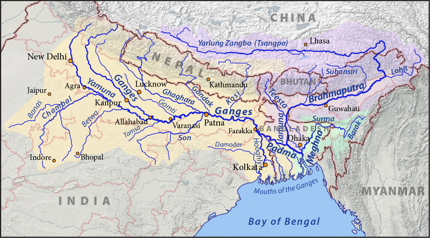
This is a list of rivers of India, starting in the west and moving along the Indian coast southward, then northward. Tributary rivers are listed hierarchically in upstream order: the lower in the list, the more upstream. The overall discharge of rivers in India or passing/originating in India : List of rivers of India by discharge The major rivers of India are: * Flowing into the Arabian Sea: Narmada, Tapi, Sindhu, Sabarmati, Mahi, Purna * Flowing into the Bay of Bengal: Brahmaputra, Yamuna, Ganga, Meghna, Mahanadi, Godavari, Krishna, Kaveri, Penna River Mizoram and Bangladesh. Meghna River Basin The Meghna-Surma-Barak River System is located in India and Bangladesh. * Meghna River (in the Bangladesh) ** ** Dhaleshwari River ** Dakatia River ** Gumti River ** Feni River ** Tista River, also called the Haora River ** Surma River *** Kangsha River **** Someshwari River ** Kushiyara River *** Manu River ** Barak River *** Tuivai River *** Irang River Ganges River Ba ... [...More Info...] [...Related Items...] OR: [Wikipedia] [Google] [Baidu] |
List Of Major Rivers Of India
The rivers in India play an important role in the lives of its people. They provide potable water, cheap transportation, electricity, and the livelihood for many people nationwide. This easily explains why nearly all the major cities of India are located by the banks of rivers. The rivers also have an important role in Hindu Religion and are considered holy by many Hindus in the country. Seven major rivers along with their numerous tributaries make up the river system of India. The largest basin system pours its waters into the Bay of Bengal; however, some of the rivers whose courses take them through the western part of the country and towards the east of the state of Himachal Pradesh empty into the Arabian Sea. Parts of Ladakh, northern parts of the Aravalli range and the arid parts of the Thar Desert have inland drainage. All major rivers of India originate from one of the following main watersheds: #Aravalli range #Himalaya and Karakoram ranges # Sahyadri or Western Ghats in ... [...More Info...] [...Related Items...] OR: [Wikipedia] [Google] [Baidu] |
Rivers Of West Bengal
A river is a natural flowing watercourse, usually freshwater, flowing towards an ocean, sea, lake or another river. In some cases, a river flows into the ground and becomes dry at the end of its course without reaching another body of water. Small rivers can be referred to using names such as creek, brook, rivulet, and rill. There are no official definitions for the generic term river as applied to geographic features, although in some countries or communities a stream is defined by its size. Many names for small rivers are specific to geographic location; examples are "run" in some parts of the United States, "burn" in Scotland and northeast England, and "beck" in northern England. Sometimes a river is defined as being larger than a creek, but not always: the language is vague. Rivers are part of the water cycle. Water generally collects in a river from precipitation through a drainage basin from surface runoff and other sources such as groundwater recharge, springs, a ... [...More Info...] [...Related Items...] OR: [Wikipedia] [Google] [Baidu] |


