|
Galilee, Queensland
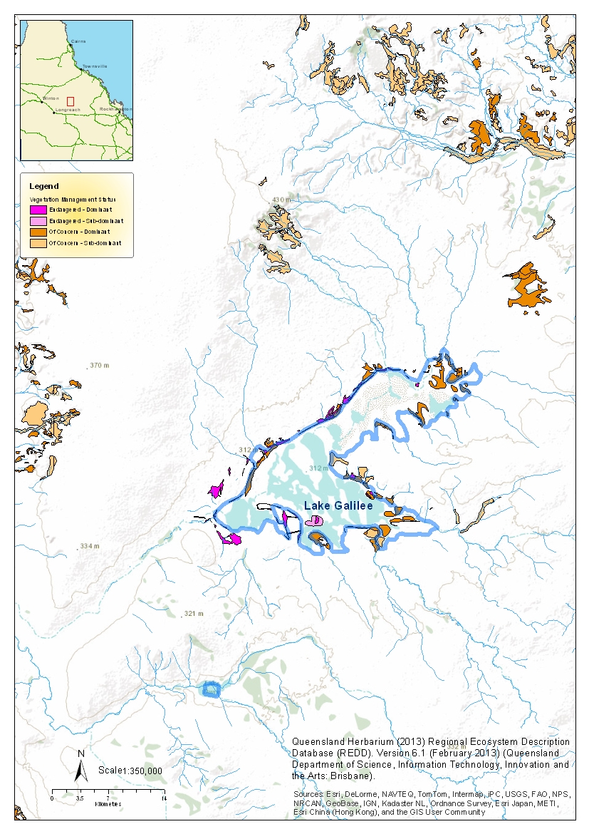
Galilee is a former rural locality in the Barcaldine Region, Queensland, Australia. In the , Galilee had a population of 20 people. On 22 November 2019 the Queensland Government decided to amalgamate the localities in the Barcaldine Region, resulting in five expanded localities based on the larger towns: Alpha, Aramac, Barcaldine, Jericho and Muttaburra. Galilee was incorporated into Aramac. Geography Galilee is bounded to the east by the Great Dividing Range and is within the Desert Uplands area of Central West Queensland. In the centre of the locality is Lake Galilee, a semi-arid saline lake which is long, up to and covers approximately . It is quite shallow, being no more than deep. Lake Galilee is registered on the Directory of Important Wetlands in Australia (DIWA) and provides an important refuge and breeding site for waterbirds. It has been identified by BirdLife International as an Important Bird Area (IBA) because it regularly supports over 1% of the world ... [...More Info...] [...Related Items...] OR: [Wikipedia] [Google] [Baidu] |
Aramac, Queensland
Aramac is a rural town and Suburbs and localities (Australia), locality in the Barcaldine Region, Queensland, Australia. In the , the locality of Aramac had a population of 372 people. Geography Aramac is located north of Barcaldine, Queensland, Barcaldine, and by road from the state capital, Brisbane. It is situated on Aramac Creek, which flows into the Thomson River (Queensland), Thomson River west of town. The Muttaburra–Aramac Road enters from the north and exits as Barcaldine–Aramac Road to the south. The predominant industry is grazing. The town water for Aramac is supplied from two bores connecting into the Great Artesian Basin. History Aramac lay on the traditional tribal lands of the Iningai. Iningai language, Iningai (also known as Yiningay, Muttaburra, Tateburra, Yinangay, Yinangi) is an Australian Aboriginal languages, Australian Aboriginal language spoken by the Iningai people. The Iningai language region includes the landscape within the local governme ... [...More Info...] [...Related Items...] OR: [Wikipedia] [Google] [Baidu] |
Jericho, Queensland
Jericho is a rural town and locality in the Barcaldine Region, Queensland, Australia. In the , the locality of Jericho had a population of 229 people. Geography Jericho is in Central West Queensland. The town is centrally located in the south of its locality. The Capricorn Highway traverses the locality from west (Garfield/Mexico) to east ( Hobartville/Mexico), passing through the town on Darwin Street. The Blackall–Jericho Road commences at the town and exits the locality via the south (Mexico). The Central Western railway passes through the town and locality, immediately to the south of the highway to the west of the town and immediately to the north of the highway to the east of the town. The town is served by the Jericho railway station on Darwin Street (). Lagoon Creek rises north of the town and exits the locality to the north-east (Garfield). Jordan Creek enters the locality from the south (Mexico), passes to the immediate east of the town and splits into two branc ... [...More Info...] [...Related Items...] OR: [Wikipedia] [Google] [Baidu] |
Cenchrus Ciliaris
''Cenchrus ciliaris'' (buffel-grass or African foxtail grass; syn. ''Pennisetum ciliare'' (L.) Link) is a species of grass native to most of Africa, southern Asia (east to India), southern Iran, and the extreme south of Europe (Sicily). Other names by which this grass is known include dhaman grass, anjan grass and koluk katai. Description African foxtail grass is a perennial grass growing to tall. The leaves are linear, long and wide. The flowers are produced in a panicle long and wide. Distribution African foxtail grass is native to tropical Africa, the Mediterranean region and the hotter and drier parts of Asia. It is a deep-rooted grass, tolerates drought, and will grow at altitudes of up to . It is considered a good forage grass in Africa. It prefers light soils with a high phosphorus content. As a key species for pastoralism, Cenchrus ciliaris is projected, in one simulation, to expand its overall range in East Africa under a high-emission scenario ( RCP 8.5) in the ... [...More Info...] [...Related Items...] OR: [Wikipedia] [Google] [Baidu] |
Grey Teal
The grey teal (''Anas gracilis'') is a dabbling duck found in open wetlands in Australia and New Zealand. Description It can be identified due to the presence of a crimson coloured iris in its eyes. This crimson colour is relatively more prominent in adult males. It is a mottled brown duck with white and green flashes on its wings. Males and females share the same colouration, in contrast to the related chestnut teal, whose male and female are strikingly different. The grey teal has almost identical colouration to the female chestnut teal and the grey can only be distinguished by its lighter coloured neck and paler face. Juveniles are paler than adults, especially on the head. However, they can be identified by a dull brown eye until matured. The bill of the grey teal is a blue-grey colour with dark lining around the edges. Feet are a similar colour to that of the bill being grey. The head of the grey teal can be described as plain/slightly streaked, with a dark crown and cream ... [...More Info...] [...Related Items...] OR: [Wikipedia] [Google] [Baidu] |
Freckled Duck
The freckled duck (''Stictonetta naevosa)'' is a waterfowl species endemic to Australia. The freckled duck has also been referred to as the monkey duck or oatmeal duck. These birds are usually present in mainland Australia, but disperse to coastal and subcostal wetlands in the dry period. During such times it is common for the freckled duck population to congregate in flocks in the same area, giving the impression that they are more common than they really are. The freckled duck population is at risk of further reduction from habitat destruction, droughts and game hunting. Often habitat destruction and drought can lead to an increase in hunting, as the freckled duck is forced to disperse into more coastal ranges where they may not be recognised as a protected species. In the past few decades, several institutions have established breeding programs to aid in supplementation of the freckled duck population. Such establishments included, but are not restricted to the Hunter Wetla ... [...More Info...] [...Related Items...] OR: [Wikipedia] [Google] [Baidu] |
Important Bird Area
An Important Bird and Biodiversity Area (IBA) is an area identified using an internationally agreed set of criteria as being globally important for the conservation of bird populations. IBA was developed and sites are identified by BirdLife International. There are over 13,000 IBAs worldwide. These sites are small enough to be entirely conserved and differ in their character, habitat or ornithological importance from the surrounding habitat. In the United States the program is administered by the National Audubon Society. Often IBAs form part of a country's existing protected area network, and so are protected under national legislation. Legal recognition and protection of IBAs that are not within existing protected areas varies within different countries. Some countries have a National IBA Conservation Strategy, whereas in others protection is completely lacking. History In 1985, following a specific request from the European Economic Community, Birdlife International dr ... [...More Info...] [...Related Items...] OR: [Wikipedia] [Google] [Baidu] |
BirdLife International
BirdLife International is a global partnership of non-governmental organizations that strives to conserve birds and their habitats. BirdLife International's priorities include preventing extinction of bird species, identifying and safeguarding important sites for birds, maintaining and restoring key bird habitats, and empowering conservationists worldwide. It has a membership of more than 2.5 million people across List of BirdLife International national partner organisations, 116 country partner organizations, including the Royal Society for the Protection of Birds, the Wild Bird Society of Japan, the National Audubon Society, and American Bird Conservancy. BirdLife International has identified 13,000 Important Bird Area, Important Bird and Biodiversity Areas and is the official International Union for Conservation of Nature's IUCN Red List, Red List authority for birds. BirdLife International has established that 1,375 bird species (13% of the total) are threatened with extinc ... [...More Info...] [...Related Items...] OR: [Wikipedia] [Google] [Baidu] |
Salt Lake
A salt lake or saline lake is a landlocked body of water that has a concentration of salts (typically sodium chloride) and other dissolved minerals significantly higher than most lakes (often defined as at least three grams of salt per liter). In some cases, salt lakes have a higher concentration of salt than sea water; such lakes can also be termed hypersaline lake, and may also be pink lakes on account of their color. An alkalic salt lake that has a high content of carbonate is sometimes termed a soda lake. Salt lakes are classified according to salinity levels. The formation of these lakes is influenced by processes such as evaporation and deposition. Salt lakes face serious conservation challenges due to climate change, pollution and water diversion. Classification The primary method of classification for salt lakes involves assessing the chemical composition of the water within the lakes, specifically its salinity, pH, and the dominant ions present. Subsaline Sub ... [...More Info...] [...Related Items...] OR: [Wikipedia] [Google] [Baidu] |
Lake Galilee (Queensland)
Lake Galilee is a semi-arid salt lake in the locality of Galilee, Queensland, Galilee, Barcaldine Region, within the Desert Uplands area of Central West Queensland, Australia. The lake is about 36 kilometres long, up to 12.5 kilometres wide and covers approximately 25,700 hectares. Lake Galilee is registered on the Directory of Important Wetlands in Australia (DIWA) and provides an important refuge and breeding site for waterbirds. It has been identified by BirdLife International as an Important Bird Area (IBA) because it regularly supports over 1% of the world populations of freckled ducks and grey teals. and possibly more than 1% of the world population of other waterbirds and shorebirds. The weed Parkinsonia aculeata, Parkinsonia is posing as an environmental threat to the lake as are feral animals, grazing impacts and tourism pressures. The group of property owners adjacent to the lake are working with local natural resource management groups (Desert Uplands Committee and D ... [...More Info...] [...Related Items...] OR: [Wikipedia] [Google] [Baidu] |
Central West Queensland
Central West Queensland (abbreviated CWQ) is a remote region in the Australian state of Queensland which covers 396,650.2 km2. The region lies to the north of South West Queensland and south of the Gulf Country. It has a population of approximately 12,387 people. As of 2018, it is one of 16 Aged Care Planning Regions (ACPR) in Queensland. History The first exploration by Europeans was by Major Thomas Mitchell who passed through the area in 1846. Mitchell was near Isisford on the Barcoo River when his party was lacking supplies and threatened by Aboriginals. He then decided to return to Sydney, completing a successful expedition which had explored a large area of unknown country. Geography The eastern extent of the Simpson Desert lies within the region. Haddon Corner and Poeppel Corner on the Queensland border are also located here. Bioregions in the area include the Channel Country. Part of the Cooper Basin is located in the region. The basin contains the most s ... [...More Info...] [...Related Items...] OR: [Wikipedia] [Google] [Baidu] |
Desert Uplands
The Desert Uplands is an interim Australian bioregion located in north and central western Queensland which straddles the Great Dividing Range between Blackall and Pentland. Geography The bioregion contains Lake Galilee, Lake Dunn and Lake Buchanan. The climate is semi-arid with highly variable rainfall. Much of the area is used for cattle grazing and is part of the Great Artesian Basin, lying within both the Galilee and Eromanga Basins. The Brigalow Belt North and Brigalow Belt South are to the east of the bioregion, and the Einasleigh Uplands are located to the north. Waterways The main rivers in the bioregion are Belyando, Cape, Campaspe, Barcoo and Alice River and Aramac and Torrens Creeks. Wetlands at shallow salt lakes Lake Galilee and Lake Buchanan are listed on the Directory of Important Wetlands in Australia. Subregions The Desert Uplands bioregion has four subregions: * Prairie-Torrens Creeks Alluvials (DEU01) – * Alice Tableland (DEU02) – * ... [...More Info...] [...Related Items...] OR: [Wikipedia] [Google] [Baidu] |


