|
GNSS Augmentation
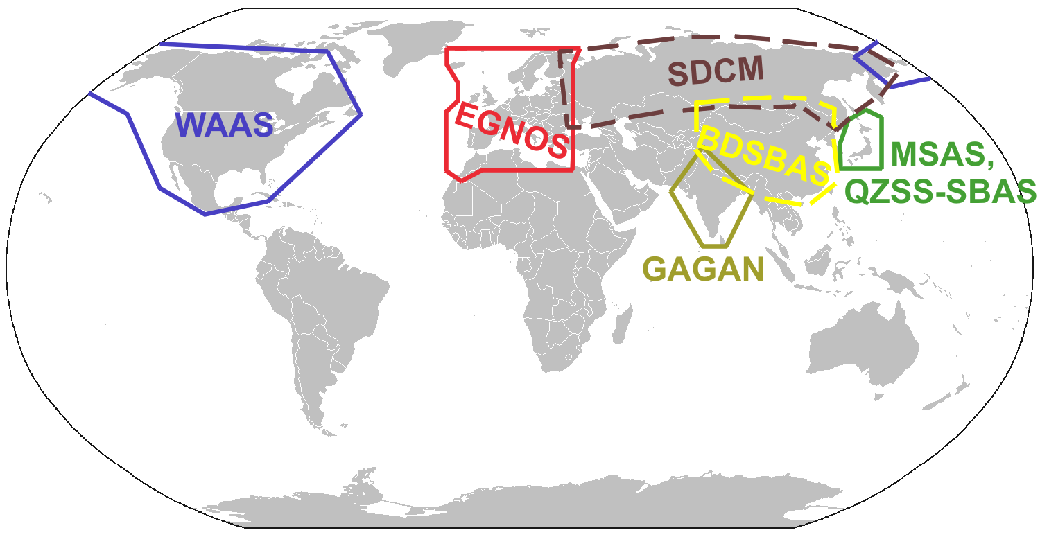
Augmentation of a Satellite navigation, global navigation satellite system (GNSS) is a method of improving the navigation system's attributes, such as precision, reliability, and availability, through the integration of external information into the calculation process. There are many such systems in place, and they are generally named or described based on how the GNSS sensor receives the external information. Some systems transmit additional information about sources of error (such as clock drift, ephemeris, or ionospheric delay), others provide direct measurements of how much the signal was off in the past, while a third group provides additional vehicle information to be integrated in the calculation process. Satellite-based augmentation system Satellite-based augmentation systems (SBAS) support wide-area or regional augmentation through the use of additional satellite-broadcast messages. Using measurements from the ground stations, correction messages are created and sent ... [...More Info...] [...Related Items...] OR: [Wikipedia] [Google] [Baidu] [Amazon] |
Satellite Navigation
A satellite navigation or satnav system is a system that uses satellites to provide autonomous geopositioning. A satellite navigation system with global coverage is termed global navigation satellite system (GNSS). , four global systems are operational: the United States's Global Positioning System (GPS), Russia's Global Navigation Satellite System (GLONASS), China's BeiDou Navigation Satellite System (BDS), and the European Union, European Union's Galileo (satellite navigation), Galileo. Two regional systems are operational: India's Indian Regional Navigation Satellite System, NavIC and Japan's Quasi-Zenith Satellite System, QZSS. ''Satellite-based augmentation systems'' (SBAS), designed to enhance the accuracy of GNSS, include Japan's Quasi-Zenith Satellite System (QZSS), India's GAGAN and the European EGNOS, all of them based on GPS. Previous iterations of the BeiDou navigation system and the present Indian Regional Navigation Satellite System (IRNSS), operationally known as ... [...More Info...] [...Related Items...] OR: [Wikipedia] [Google] [Baidu] [Amazon] |
Quasi-Zenith Satellite System
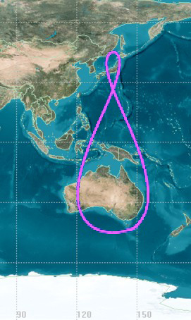
The , also known as , is a four-satellite regional satellite navigation system and a GNSS augmentation#Satellite-based augmentation system, satellite-based augmentation system developed by the Japanese government to enhance the United States-operated Global Positioning System (GPS) in the Asia-Pacific, Asia-Oceania regions, with a focus on Japan. The goal of QZSS is to provide highly precise and stable positioning services in the Asia-Oceania region, compatible with GPS. Four-satellite QZSS services were available on a trial basis as of 12 January 2018, and officially started on 1 November 2018. A satellite navigation system independent of GPS is planned for 2023 with seven satellites. In May 2023 it was announced that the system would expand to eleven satellites. History In 2002, the Japanese government authorized the development of QZSS, as a three-satellite regional time transfer system and a GNSS augmentation#SatelliteBasedAugmentationSystem, satellite-based augmentatio ... [...More Info...] [...Related Items...] OR: [Wikipedia] [Google] [Baidu] [Amazon] |
Wide Area GPS Enhancement
Wide Area GPS Enhancement (WAGE) is a method to increase the horizontal accuracy of the GPS The Global Positioning System (GPS) is a satellite-based hyperbolic navigation system owned by the United States Space Force and operated by Mission Delta 31. It is one of the global navigation satellite systems (GNSS) that provide geol ... encrypted GPS signals, P(Y) Code by adding additional range correction data to the satellite broadcast navigation message. Per a 1997 article, the navigation message for each satellite is updated once daily or as needed. This daily update of each satellite navigation message contains the range corrections for all the satellites in the constellation. Thus, more timely range correction information would be available for each satellite, resulting in increased horizontal accuracy. Potential improvements to the system include simplifying the upload procedure, uploading the data more often, and adding more monitor stations for better range correct ... [...More Info...] [...Related Items...] OR: [Wikipedia] [Google] [Baidu] [Amazon] |
Southern Positioning Augmentation Network
The Southern Positioning Augmentation Network (SouthPAN) is a joint initiative of the Australian and New Zealand Governments that provides satellite-based augmentation system Augmentation of a global navigation satellite system (GNSS) is a method of improving the navigation system's attributes, such as precision, reliability, and availability, through the integration of external information into the calculation process. ... (SBAS) for Australia and New Zealand. On 26 September 2022, SouthPAN early Open Services became live, with safety-of-life certified SouthPAN services planned for 2028. SouthPAN is the first SBAS in the Southern Hemisphere. SouthPAN will implement the following services: * L1 SBAS. L1 SBAS augments GPS and is an Aeronautical Radio Navigation Service (ARNS). This signal will be used for Safety-of-Life applications and therefore needs to be certified by the National Aviation Authorities—that is, the Australian Civil Aviation Safety Authority (CASA) and New Zeala ... [...More Info...] [...Related Items...] OR: [Wikipedia] [Google] [Baidu] [Amazon] |
BeiDou
The BeiDou Navigation Satellite System (BDS; ) is a satellite-based radio navigation system owned and operated by the China National Space Administration. It provides geolocation and time information to a BDS receiver anywhere on or near the Earth where there is an unobstructed line of sight to four or more BDS satellites. It does not require the user to transmit any data and operates independently of any telephonic or Internet reception, though these technologies can enhance the usefulness of the BDS positioning information. The current service, BeiDou-3 (third-generation BeiDou), provides full global coverage for timing and navigation, along with Russia's GLONASS, the European Galileo, and the US's GPS. It consists of satellites in three different orbits, including 24 satellites in medium-circle orbits (covering the world), 3 satellites in inclined geosynchronous orbits (covering the Asia-Pacific region), and 3 satellites in geostationary orbits (covering China). The BeiDo ... [...More Info...] [...Related Items...] OR: [Wikipedia] [Google] [Baidu] [Amazon] |
China
China, officially the People's Republic of China (PRC), is a country in East Asia. With population of China, a population exceeding 1.4 billion, it is the list of countries by population (United Nations), second-most populous country after India, representing 17.4% of the world population. China spans the equivalent of five time zones and Borders of China, borders fourteen countries by land across an area of nearly , making it the list of countries and dependencies by area, third-largest country by land area. The country is divided into 33 Province-level divisions of China, province-level divisions: 22 provinces of China, provinces, 5 autonomous regions of China, autonomous regions, 4 direct-administered municipalities of China, municipalities, and 2 semi-autonomous special administrative regions. Beijing is the country's capital, while Shanghai is List of cities in China by population, its most populous city by urban area and largest financial center. Considered one of six ... [...More Info...] [...Related Items...] OR: [Wikipedia] [Google] [Baidu] [Amazon] |
BeiDou Satellite-based Augmentation System
The BeiDou Navigation Satellite System (BDS; ) is a satellite-based radio navigation system owned and operated by the China National Space Administration. It provides geolocation and time information to a BDS receiver anywhere on or near the Earth where there is an unobstructed line of sight to four or more BDS satellites. It does not require the user to transmit any data and operates independently of any telephonic or Internet reception, though these technologies can enhance the usefulness of the BDS positioning information. The current service, BeiDou-3 (third-generation BeiDou), provides full global coverage for timing and navigation, along with Russia's GLONASS, the European Galileo, and the US's GPS. It consists of satellites in three different orbits, including 24 satellites in medium-circle orbits (covering the world), 3 satellites in inclined geosynchronous orbits (covering the Asia-Pacific region), and 3 satellites in geostationary orbits (covering China). The BeiDou ... [...More Info...] [...Related Items...] OR: [Wikipedia] [Google] [Baidu] [Amazon] |
GLONASS
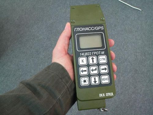
GLONASS (, ; ) is a Russian satellite navigation system operating as part of a radionavigation-satellite service. It provides an alternative to Global Positioning System (GPS) and is the second navigational system in operation with global coverage and of comparable precision. Satellite navigation devices supporting both GPS and GLONASS have more satellites available, meaning positions can be fixed more quickly and accurately, especially in built-up areas where buildings may obscure the view to some satellites. Owing to its higher orbital inclination, GLONASS supplementation of GPS systems also improves positioning in high latitudes (near the poles). Development of GLONASS began in the Soviet Union in 1976. Beginning on 12 October 1982, numerous rocket launches added satellites to the system until the completion of the Satellite constellation, constellation in 1995. In 2001, after a decline in capacity during the late 1990s, the restoration of the system was made a government p ... [...More Info...] [...Related Items...] OR: [Wikipedia] [Google] [Baidu] [Amazon] |
Roscosmos
The State Corporation for Space Activities "Roscosmos", commonly known simply as Roscosmos (), is a State corporation (Russia), state corporation of the Russian Federation responsible for space science, space flights, List of space agencies, cosmonautics programs, and aerospace research. Originating from the Soviet space program founded in the 1950s, Roscosmos emerged following the dissolution of the Soviet Union in 1991. It initially began as the Russian Space Agency,, ''Rossiyskoye kosmicheskoye agentstvo'', or RKA (). which was established on 25 February 1992 and restructured in 1999 and 2004 as the Russian Aviation and Space Agency, ''Rossiyskoye aviatsionno-kosmicheskoye agentstvo'', commonly known as (), established on 25 May 1999. and the Federal Space Agency (Roscosmos), (Роскосмос), ''Federalnoye kosmicheskoye agentstvo (Roskosmos)''. respectively. In 2015, the Federal Space Agency (Roscosmos) was merged with the United Rocket and Space Corporation, ... [...More Info...] [...Related Items...] OR: [Wikipedia] [Google] [Baidu] [Amazon] |
Russia
Russia, or the Russian Federation, is a country spanning Eastern Europe and North Asia. It is the list of countries and dependencies by area, largest country in the world, and extends across Time in Russia, eleven time zones, sharing Borders of Russia, land borders with fourteen countries. Russia is the List of European countries by population, most populous country in Europe and the List of countries and dependencies by population, ninth-most populous country in the world. It is a Urbanization by sovereign state, highly urbanised country, with sixteen of its urban areas having more than 1 million inhabitants. Moscow, the List of metropolitan areas in Europe, most populous metropolitan area in Europe, is the capital and List of cities and towns in Russia by population, largest city of Russia, while Saint Petersburg is its second-largest city and Society and culture in Saint Petersburg, cultural centre. Human settlement on the territory of modern Russia dates back to the ... [...More Info...] [...Related Items...] OR: [Wikipedia] [Google] [Baidu] [Amazon] |
System For Differential Corrections And Monitoring
The System for Differential Corrections and Monitoring (SDCM), is the satellite-based navigation augmentation system operated by Russia's Roscosmos space agency to augment the precision of the GLONASS satellite navigation system. It uses the Luch Multifunctional Space Relay System to transmit correction data. SDCM's service area covers the Russian Federation Russia, or the Russian Federation, is a country spanning Eastern Europe and North Asia. It is the list of countries and dependencies by area, largest country in the world, and extends across Time in Russia, eleven time zones, sharing Borders .... it had not yet been certified for use for public aviation. References External links Design summary for SDCM 2012 Navigation satellite constellations Satellite-based augmentation systems {{satellite-stub ... [...More Info...] [...Related Items...] OR: [Wikipedia] [Google] [Baidu] [Amazon] |
The Hindu
''The Hindu'' is an Indian English-language daily newspaper owned by The Hindu Group, headquartered in Chennai, Tamil Nadu. It was founded as a weekly publication in 1878 by the Triplicane Six, becoming a daily in 1889. It is one of the Indian Newspaper of record, newspapers of record. , ''The Hindu'' is published from 21 locations across 11 states of India. ''The Hindu'' has been a family-owned newspaper since 1905, when it was purchased by S. Kasturi Ranga Iyengar from the original founders. It is now jointly owned by Iyengar's descendants, referred to as the "Kasturi family", who serve as the directors of the holding company. Except for a period of around two years, when Siddharth Varadarajan, S. Varadarajan held the editorship of the newspaper, senior editorial positions of the paper have always been held by members of the original Iyengar family or by those appointed by them under their direction. In June 2023, the former chairperson of the group, Malini Parthasarathy, w ... [...More Info...] [...Related Items...] OR: [Wikipedia] [Google] [Baidu] [Amazon] |


