|
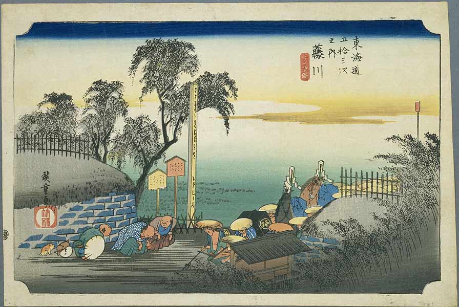
Fujikawa-shuku
was the thirty-seventh of the fifty-three stations of the Tōkaidō. It is located in the present-day city of Okazaki, in Aichi Prefecture, Japan. It was approximately from Akasaka-juku, the preceding post station.Tokaido 53: Fujikawa-juku (Okazaki) . Tōkaidō no Tabi. Accessed March 6, 2008. Another accepted reading for this post town is "Fujikawa-juku." At its peak, Fujikawa-juku was home to 302 buildings, including one '' honjin'', one sub-''honjin'' and 36 '' hatago''. Its total population was approximately 1,200 people. The classic |
53 Stations Of The Tōkaidō
The are the rest areas along the Tōkaidō, which was a coastal route that ran from Nihonbashi in Edo (modern-day Tokyo) to Sanjō Ōhashi in Kyoto.. There were originally 53 government post stations along the Tōkaidō, where travelers had to present traveling permits at each station if wanting to cross. In 1619, the Ōsaka Kaidō (大阪街道) was developed to extend the Tōkaidō so that it would reach Kōraibashi in modern-day Osaka. Instead of going to Sanjō Ōhashi, travelers would leave from Ōtsu-juku and travel towards Fushimi-juku. Because of the addition of these four post towns, the Tōkaidō is occasionally referred to as having 57 stations. Another name for this extension was Kyōkaidō (京街道). The inland Nakasendō also started at Nihonbashi, and converged with the Tōkaidō at Kusatsu-juku. Shio no Michi intersected with the Tōkaidō at Okazaki-shuku. Stations of the Tōkaidō See also * Edo Five Routes ** 69 Stations of the Nakase ... [...More Info...] [...Related Items...] OR: [Wikipedia] [Google] [Baidu] |
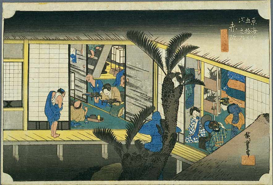
Akasaka-juku (Tōkaidō)
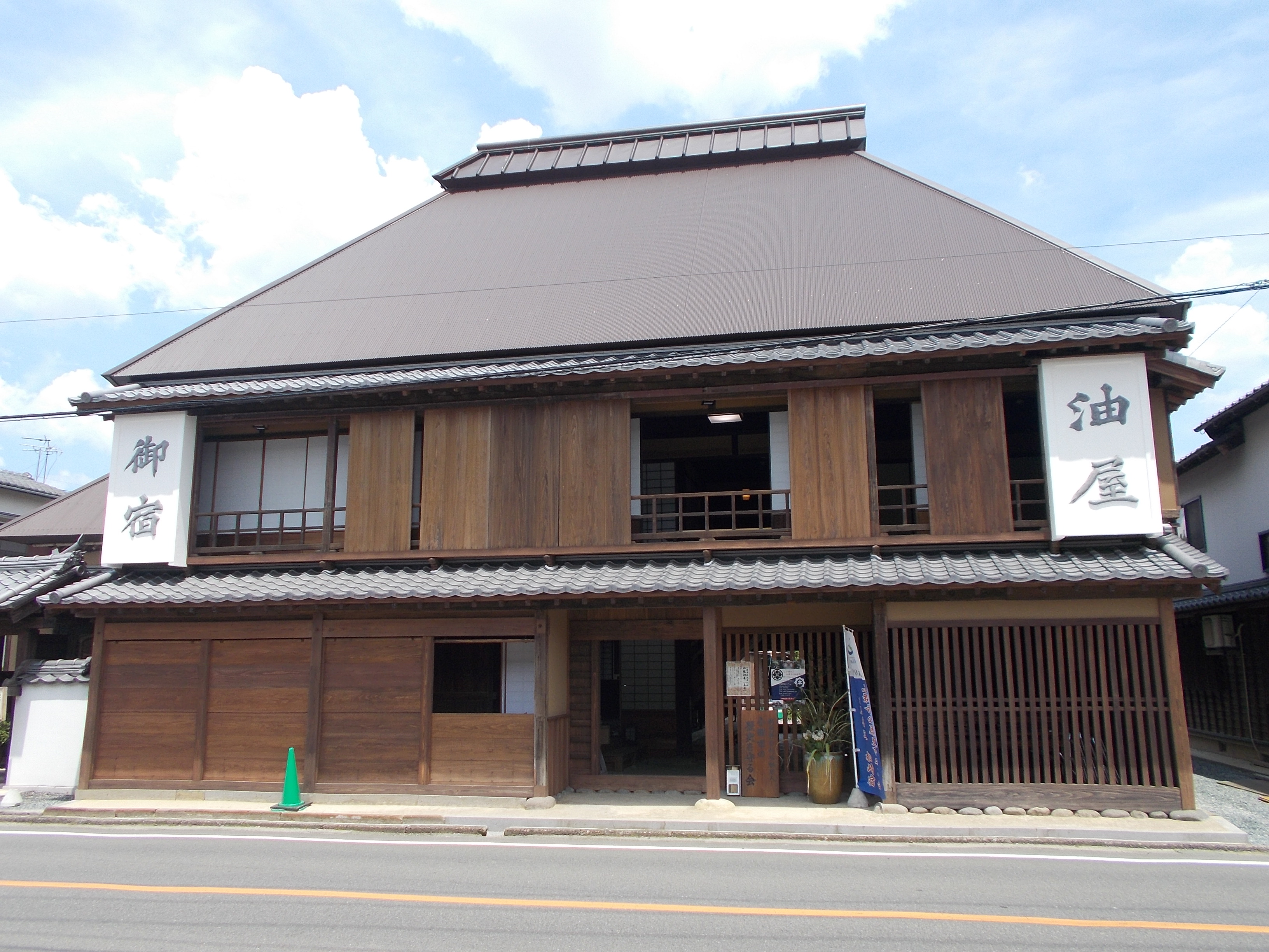
was the thirty-sixth of the fifty-three stations of the Tōkaidō. It is located in present-day Toyokawa, Aichi Prefecture, Japan. It was only from Goyu-juku, the preceding post station. History Along with the preceding Yoshida-juku and Goyu-shuku, Akasaka-juku was well known for its '' meshimori onna''. The classic ukiyo-e print by Andō Hiroshige (''Hoeido'' edition) from 1831–1834 depicts a typical inn; the scene is divided in half by a sago palm in the center. To the right, travellers are taking their evening meal, and to the left, prostitutes are putting on make-up and preparing for the evening entertainment. Due to its reputation, Akasaka was a popular post station with many travellers. Ōhashi-ya (大橋屋), an inn that first opened in 1649, less than half a century after the creation of the Tōkaidō, still operates today. The building it uses was built in 1716. During a census in 1733, there were 83 inns in Akasaka-juku, but only Ōhashi-ya remains today. ... [...More Info...] [...Related Items...] OR: [Wikipedia] [Google] [Baidu] |
Okazaki-shuku
was the thirty-eighth of the fifty-three stations of the Tōkaidō. It is located in the present-day city of Okazaki, in Aichi Prefecture, Japan. History Okazaki-shuku was a part of the flourishing castle town surrounding Okazaki Castle, the headquarters for Okazaki Domain. The classic ukiyo-e print by Andō Hiroshige (Hōeidō edition) from 1831 to 1834 depicts a ''Yahagibashi'', one of the few bridges permitted by the Tokugawa shogunate on the Tōkaidō, and one of the longest bridges built in Japan during the early Edo period. Okazaki Castle is depicted in the distance on the far shore of the river. Following the Meiji restoration, with the construction of railroads, the route of what became the Tokaido Main Line was laid down through the nearby village of Hane ( ''Hane-mura'') to the south. Unlike Goyu-shuku and Akasaka-juku, but this did not cause a huge economic decline to Okazaki-shuku. There was a horse-drawn rail line connecting Okazaki to the train station, as ... [...More Info...] [...Related Items...] OR: [Wikipedia] [Google] [Baidu] |
Tōkaidō (road)
The , which roughly means "eastern sea route," was the most important of the Five Routes of the Edo period in Japan, connecting Kyoto to Edo (modern-day Tokyo). Unlike the inland and less heavily travelled Nakasendō, the Tōkaidō travelled along the sea coast of eastern Honshū, hence the route's name. Traveling the Tōkaidō The standard method of travel was on foot, as wheeled carts were almost nonexistent and heavy cargo was usually sent by boat. Members of the higher class, however, travelled by ''kago''. Women were forbidden to travel alone and had to be accompanied by men. Other restrictions were also put in place for travellers, but, while severe penalties existed for various travel regulations, most seem not to have been enforced. Captain Sherard Osborn, who travelled part of the road in around 1858, noted that: Along the Tōkaidō, there were government-sanctioned post stations (shukuba) for travellers' rest. These stations consisted of porter stations and horse ... [...More Info...] [...Related Items...] OR: [Wikipedia] [Google] [Baidu] |
Okazaki, Aichi
is a city located in Aichi Prefecture, Japan. , the city had an estimated population of 386,999 in 164,087 households, and a population density of 999 persons per km². The total area of the city was . Geography Okazaki is in the coastal plains of southeastern Aichi Prefecture. The ground rises to undulating hills in the former Nukata area to the northeast. About 60 percent of the city area is forested and remains sparsely populated. Okazaki is about from Tokyo, to the southwest. Climate The city has a climate characterized by hot and humid summers, and relatively mild winters (Köppen climate classification ''Cfa''). The average annual temperature in Okazaki is . The average annual rainfall is with September as the wettest month. The temperatures are highest on average in August, at around , and lowest in January, at around . Demographics Per Japanese census data, the population of Okazaki has grown steadily over the past 60 years. This fast population growth reflects the l ... [...More Info...] [...Related Items...] OR: [Wikipedia] [Google] [Baidu] |
Aichi Prefecture
is a prefecture of Japan located in the Chūbu region of Honshū. Aichi Prefecture has a population of 7,552,873 () and a geographic area of with a population density of . Aichi Prefecture borders Mie Prefecture to the west, Gifu Prefecture and Nagano Prefecture to the north, and Shizuoka Prefecture to the east. Overview Nagoya is the capital and largest city of Aichi Prefecture, and the fourth-largest city in Japan, with other major cities including Toyota, Okazaki, and Ichinomiya. Aichi Prefecture and Nagoya form the core of the Chūkyō metropolitan area, the third-largest metropolitan area in Japan and one of the largest metropolitan areas in the world. Aichi Prefecture is located on Japan's Pacific Ocean coast and forms part of the Tōkai region, a subregion of the Chūbu region and Kansai region. Aichi Prefecture is home to the Toyota Motor Corporation. Aichi Prefecture had many locations with the Higashiyama Zoo and Botanical Gardens, The Chubu Centrair Internat ... [...More Info...] [...Related Items...] OR: [Wikipedia] [Google] [Baidu] |
Japan
Japan ( ja, 日本, or , and formally , ''Nihonkoku'') is an island country in East Asia. It is situated in the northwest Pacific Ocean, and is bordered on the west by the Sea of Japan, while extending from the Sea of Okhotsk in the north toward the East China Sea, Philippine Sea, and Taiwan in the south. Japan is a part of the Ring of Fire, and spans Japanese archipelago, an archipelago of List of islands of Japan, 6852 islands covering ; the five main islands are Hokkaido, Honshu (the "mainland"), Shikoku, Kyushu, and Okinawa Island, Okinawa. Tokyo is the Capital of Japan, nation's capital and largest city, followed by Yokohama, Osaka, Nagoya, Sapporo, Fukuoka, Kobe, and Kyoto. Japan is the List of countries and dependencies by population, eleventh most populous country in the world, as well as one of the List of countries and dependencies by population density, most densely populated and Urbanization by country, urbanized. About three-fourths of Geography of Japan, the c ... [...More Info...] [...Related Items...] OR: [Wikipedia] [Google] [Baidu] |
Shukuba
were post stations during the Edo period in Japan, generally located on one of the Edo Five Routes or one of its sub-routes. They were also called ''shuku-eki'' (宿駅). These post stations (or "post towns") were places where travelers could rest on their journey around the nation. They were created based on policies for the transportation of goods by horseback that were developed during the Nara and Heian periods. History These post stations were first established by Tokugawa Ieyasu shortly after the end of the Battle of Sekigahara. The first post stations were developed along the Tōkaidō (followed by stations on the Nakasendō and other routes). In 1601, the first of the Tōkaidō's fifty-three stations were developed, stretching from Shinagawa-juku in Edo to Ōtsu-juku in Ōmi Province. Not all the post stations were built at the same time, however, as the last one was built in 1624. The lodgings in the post stations were established for use by public officials and, ... [...More Info...] [...Related Items...] OR: [Wikipedia] [Google] [Baidu] |
Honjin
The ''honjin'' at Inaba Kaidō's Ōhara-shuku.">Ōhara-shuku.html" ;"title="Inaba Kaidō's Ōhara-shuku">Inaba Kaidō's Ōhara-shuku. is the Japanese word for an inn for government officials, generally located in post stations (''shukuba'') during the later part of the Edo period. Evolution of ''Honjin'' Originally, ''honjin'' were places from which generals directed battles and, therefore, were fleeting in nature. However, as commanders began to transform the ''honjin'' into temporary lodgings during battle and travel, ''honjin'' came to be places where ''daimyō'' and other representatives of the shogunate, including ''hatamoto'', ''monzeki'', etc., were allowed to stay during their travels. Many of the ''honjin'' were actually personal residences of village and town leaders. As such, they received official designations from the government and expanded their residences to include walls, gates and other features. Because of their cooperation, the owners of the ''honjin'' also ... [...More Info...] [...Related Items...] OR: [Wikipedia] [Google] [Baidu] |
Hatago
were Edo period lodgings for travelers at '' shukuba'' (post stations) along the national highways, including the Edo Five Routes The , sometimes translated as "Five Highways", were the five centrally administered routes, or ''kaidō'', that connected the ''de facto'' capital of Japan at Edo (now Tokyo) with the outer provinces during the Edo period (1603–1868). The most ... and the subroutes. In addition to a place to rest, ''hatago'' also offered meals and other foods to the travelers. They were also called . Name origin ''Hatago'' means "traveling basket." The word itself originally derived from baskets that contained food for horses and were carried by travelers. From there, it became a tool with which travelers were carry their own food and goods. Shops that began preparing and selling food for travelers gained the suffix , meaning "shop," but this was eventually shortened to just ''hatago''. Preserved ''hatago'' Because many post stations along the Tōkaidō, Nakas ... [...More Info...] [...Related Items...] OR: [Wikipedia] [Google] [Baidu] |
Ukiyo-e
Ukiyo-e is a genre of Japanese art which flourished from the 17th through 19th centuries. Its artists produced woodblock prints and paintings Painting is the practice of applying paint, pigment, color or other medium to a solid surface (called the "matrix" or "support"). The medium is commonly applied to the base with a brush, but other implements, such as knives, sponges, and ai ... of such subjects as female beauties; kabuki actors and sumo wrestlers; scenes from history and folk tales; travel scenes and landscapes; Flora of Japan, flora and Wildlife of Japan#Fauna, fauna; and Shunga, erotica. The term translates as "picture[s] of the floating world". In 1603, the city of Edo (Tokyo) became the seat of the ruling Tokugawa shogunate. The ''chōnin'' class (merchants, craftsmen and workers), positioned at the bottom of Four occupations, the social order, benefited the most from the city's rapid economic growth, and began to indulge in and patronise the entertainment o ... [...More Info...] [...Related Items...] OR: [Wikipedia] [Google] [Baidu] |


.jpg)
_02.jpg)


