|
Fort Rotterdam
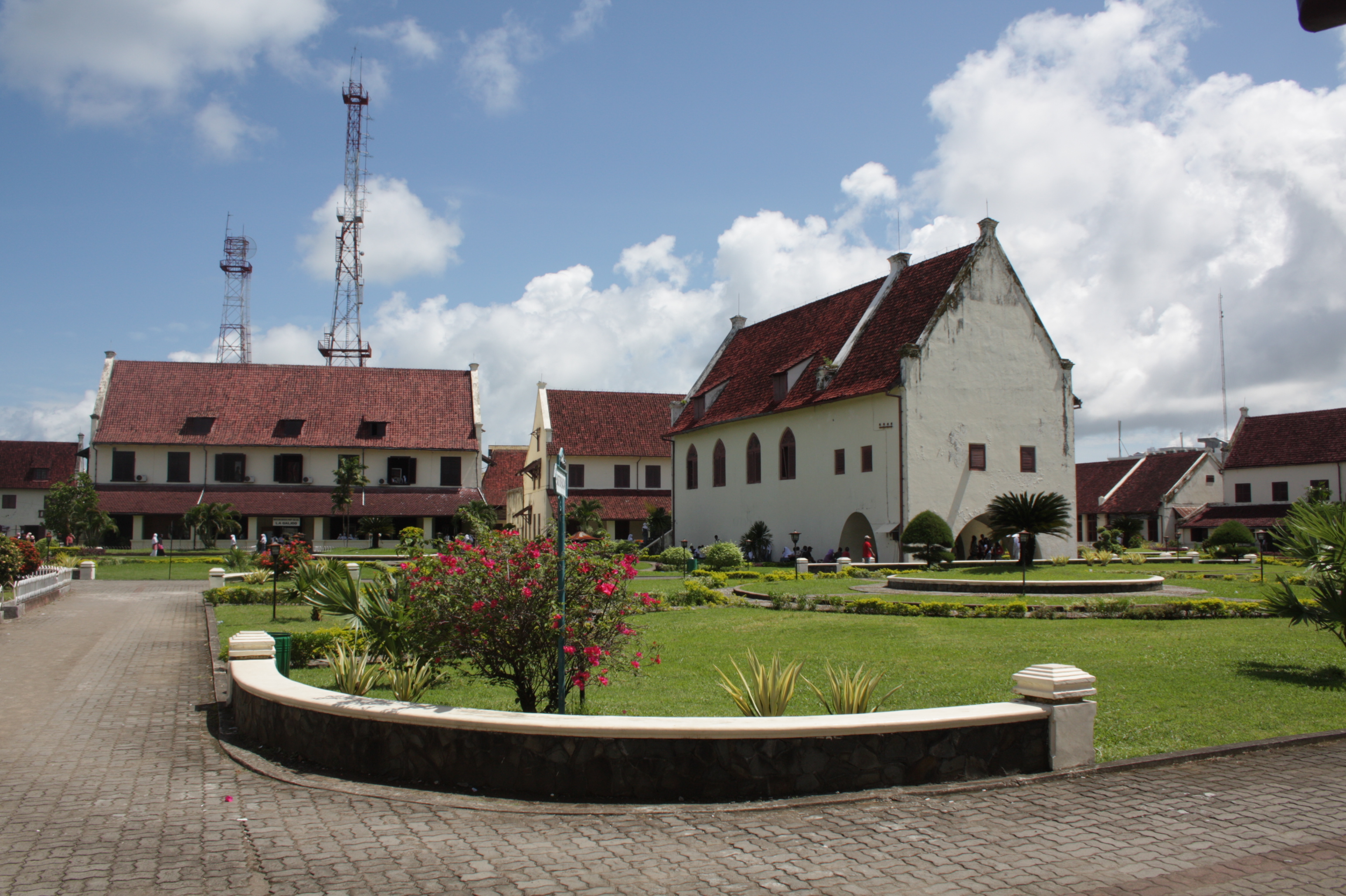
Fort Rotterdam is a 17th-century fort in Makassar on the island of Sulawesi in Indonesia. It is a Dutch fort built on top of an existing fort of the Gowa Kingdom. The first fort on the site was constructed by the a local sultan in around 1634, to counter Dutch encroachments. The site was ceded to the Dutch under the Treaty of Bongaya, and they completely rebuilt it between 1673 and 1679. It had six bastions and was surrounded by a seven meter high rampart and a two meter deep moat. The fort was the Dutch regional military and governmental headquarters until the 1930s. It was extensively restored in the 1970s and is now a cultural and educational centre, a venue for music and dance events, and a tourist destination. History Fort Rotterdam was built on the location of an earlier Makassarese fort, called Ujung Pandang. It seems more likely that the fort was built in 1634, as part of a fortification programme that the Makassar rulers undertook in response to a war with the Dutch E ... [...More Info...] [...Related Items...] OR: [Wikipedia] [Google] [Baidu] |
Makassar
Makassar (, mak, ᨆᨀᨔᨑ, Mangkasara’, ) is the capital of the Indonesian province of South Sulawesi. It is the largest city in the region of Eastern Indonesia and the country's fifth-largest urban center after Jakarta, Surabaya, Medan, and Bandung.Ministry of Internal AffairsRegistration Book for Area Code and Data of 2013/ref> The city is located on the southwest coast of the island of Sulawesi, facing the Makassar Strait. Throughout its history, Makassar has been an important trading port, hosting the center of the Gowa Sultanate and a Portuguese naval base before its conquest by the Dutch East India Company in the 17th century. It remained an important port in the Dutch East Indies, serving Eastern Indonesian regions with Makassarese fishers going as far south as the Australian coast. For a brief period after Indonesian independence, Makassar became the capital of the State of East Indonesia, during which an uprising occurred. The city's area is , and it had ... [...More Info...] [...Related Items...] OR: [Wikipedia] [Google] [Baidu] |
Java War
The Java War ( jv, ꦥꦼꦫꦁꦗꦮ) or Diponegoro War () was fought in central Java from 1825 to 1830, between the colonial Dutch Empire and native Javanese rebels. The war started as a rebellion led by Prince Diponegoro, a leading member of the Javanese aristocracy who had previously cooperated with the Dutch. The rebel forces laid siege to Yogyakarta, a move that prevented a quick victory. This gave the Dutch time to reinforce their army with colonial and European troops, allowing them to end the siege in 1825. After this defeat, the rebels continued fighting a guerrilla war for five years. The war ended in a Dutch victory, and Prince Diponegoro was invited to a peace conference. He was betrayed and captured. Due to the cost of the war, Dutch colonial authorities implemented major reforms throughout the Dutch East Indies to ensure the colonies remained profitable. History The direct cause of the Java War was the decision by the Dutch to build a road across a piece of ... [...More Info...] [...Related Items...] OR: [Wikipedia] [Google] [Baidu] |
Forts In Indonesia
A fortification is a military construction or building designed for the defense of territories in warfare, and is also used to establish rule in a region during peacetime. The term is derived from Latin ''fortis'' ("strong") and ''facere'' ("to make"). From very early history to modern times, defensive walls have often been necessary for cities to survive in an ever-changing world of invasion and conquest. Some settlements in the Indus Valley civilization were the first small cities to be fortified. In ancient Greece, large stone walls had been built in Mycenaean Greece, such as the ancient site of Mycenae (famous for the huge stone blocks of its 'cyclopean' walls). A Greek '' phrourion'' was a fortified collection of buildings used as a military garrison, and is the equivalent of the Roman castellum or English fortress. These constructions mainly served the purpose of a watch tower, to guard certain roads, passes, and borders. Though smaller than a real fortress, they acted ... [...More Info...] [...Related Items...] OR: [Wikipedia] [Google] [Baidu] |
Colonial Architecture In Indonesia
The colonial architecture of Indonesia refers to the buildings that were created across Indonesia during the Dutch colonial period, during that time, this region was known as the Dutch East Indies. These types of colonial era structures are more prevalent in Java and Sumatra, as those islands were considered more economically significant during the Dutch imperial period. As a result of this, there is a large number of well preserved colonial era buildings that are still densely concentrated within Indonesian cities in Java and Sumatra to this day. In the rest of the archipelago, there is also a sizeable amount of old Dutch East India Company (VOC) era forts and warehouses that were built during the Dutch colonial period of Indonesia, particularly around the Maluku Islands and Sulawesi, though these tend to be more scattered about and in less dense concentrations compared to those found on Java and Sumatra. The three styles of colonial architecture in Indonesia are: * Old Indie ... [...More Info...] [...Related Items...] OR: [Wikipedia] [Google] [Baidu] |
Lontar Manuscripts
Palm-leaf manuscripts are manuscripts made out of dried palm leaves. Palm leaves were used as writing materials in the Indian subcontinent and in Southeast Asia reportedly dating back to the 5th century BCE. Their use began in South Asia and spread to other regions, as texts on dried and smoke-treated palm leaves of Palmyra palm or the talipot palm. Their use continued till the 19th century, when printing presses replaced hand-written manuscripts. One of the oldest surviving palm leaf manuscripts of a complete treatise is a Sanskrit Shaivism text from the 9th-century, discovered in Nepal, now preserved at the Cambridge University Library.Pārameśvaratantra (MS Add.1049.1) with images , Puṣkarapārameśvaratantra, University of Cambridge (2015) The [...More Info...] [...Related Items...] OR: [Wikipedia] [Google] [Baidu] |
Watampone
Watampone is a town in South Sulawesi and the capital of Bone Regency. Known colloquially as ''Bone'', it has a land area of 126.35 km2 and had a population of 149,336 at the 2020 Census.Badan Pusat Statistik, Jakarta, 2021. It is divided administratively into three districts (''kecamatan'') within the Bone Regency. It is also the birthplace of the 10th and 12th Vice President of the Republic of Indonesia Jusuf Kalla. Climate Watampone has a tropical rainforest climate A tropical rainforest climate, humid tropical climate or equatorial climate is a tropical climate sub-type usually found within 10 to 15 degrees latitude of the equator. There are some other areas at higher latitudes, such as the coast of southea ... (Af) with moderate rainfall from September to November and heavy to very heavy rainfall in the remaining months. References Populated places in South Sulawesi Regency seats of South Sulawesi {{SSulawesi-geo-stub ... [...More Info...] [...Related Items...] OR: [Wikipedia] [Google] [Baidu] |
Predikant
Predikant is a minister in the Dutch Reformed Church in South Africa. Predikant is the Afrikaans term for "pastor". The word 'predikant' is also used in the Dutch, West Frisian, Norwegian and Swedish Swedish or ' may refer to: Anything from or related to Sweden, a country in Northern Europe. Or, specifically: * Swedish language, a North Germanic language spoken primarily in Sweden and Finland ** Swedish alphabet, the official alphabet used by ... languages. References {{Christianity-stub Afrikaans words and phrases South African English Christian religious occupations Ecclesiastical titles ... [...More Info...] [...Related Items...] OR: [Wikipedia] [Google] [Baidu] |
Ambon, Maluku
Ambon (formerly nl, Amboina) is the capital and largest city of the Indonesian province of Maluku. This city is also known as , which means "beautiful" or "pretty" Ambon. It covers a land area of 298.61 km2, and had a population of 331,254 at the 2010 Census and 347,288 at the 2020 Census. The city is divided into five administrative districts () – namely Nusaniwe, Sirimau, Teluk Ambon (Ambon Bay), Baguala and Leitimur Selatan (South Leitimur). Known as Indonesia's music city, Ambon became the first city in Southeast Asia to be recognised as the UNESCO City of Music in 2019. The city is populated by a mix of ethnic Alifuru (original Moluccans), Javanese, Balinese, Butonese, Bugis, Makassar, Papuan, Minahasa, Minang, Flobamora (Flores, Sumba, Alor and Timor ethnics) and those of foreign descent (Chinese, Arabian-Ambonese, Spanish-Ambonese, German-Ambonese, Portuguese-Ambonese and Dutch-Ambonese). Between 1999 and 2002, there was social unrest motivated by raci ... [...More Info...] [...Related Items...] OR: [Wikipedia] [Google] [Baidu] |
Bacan Islands
The Bacan Islands, formerly also known as the Bachans, Bachians, and Batchians, are a group of islands in the Moluccas in Indonesia. They are mountainous and forested, lying south of Ternate and southwest of Halmahera. The islands are administered by the South Halmahera Regency of North Maluku Province. They formerly constituted the Sultanate of Bacan. Bacan ( nl, Batjan), formerly also known as Bachian or Batchian, is the group's largest island. The second and third-largest islands are Kasiruta and Mandioli. Bacan Island in 2020 included about 82,387 people, of which about 10,000 live in the capital Labuha; it is subdivided into seven districts. Kasiruta and Mandioli each have over 10,000 inhabitants, and each is subdivided into two districts. A fourth island, Bacan Lomang, forms a twelfth district within the group. There are dozens of smaller islands in the group, which had a total population of 84,075 at the 2010 Census, but by the 2020 Census had risen to 111,517. The offic ... [...More Info...] [...Related Items...] OR: [Wikipedia] [Google] [Baidu] |
Buton Island
Buton (also Butung, Boeton or Button) is an island in Indonesia located off the southeast peninsula of Sulawesi. It covers roughly 4,727 square kilometers in area, or about the size of Madura; it is the 129th largest island in the world and Indonesia's 19th largest in area. History In the precolonial era, the island, then usually known as Butung, was within the sphere of influence of Ternate. Especially in the sixteenth century, Buton served as an important secondary regional center within the Ternaten empire, controlling regional trade and collecting tribute to be sent to Ternate. The Sultanate of Buton ruled over the island from the 14th until the 20th century. Sultan Murhum, the first Islamic monarch on the island, is remembered in the name of the island's major harbor, Murhum Harbor, in Baubau. Geography Its largest town is Baubau, where the Wolio and Cia-Cia languages are spoken. Major nearby islands include Wawonii (to the north), Muna and Kabaena (to the west) and S ... [...More Info...] [...Related Items...] OR: [Wikipedia] [Google] [Baidu] |
Bone State
Bone (also ''Boni'', or ''Bone Saoraja'') was a sultanate in the south-west peninsula of what is now Sulawesi (formerly Celebes), a province of modern-day Indonesia. It came under Dutch rule in 1905, and was succeeded by the Bone Regency. Covering an area of , Bone's chief town Boni, lay northeast of the city of Makassar, home to the Bugis people. History Bone was an '' adat''-based Bugis kingdom whose origins can be traced back to the early 15th century. Its chronicle (as yet unpublished) provides detailed information on its rulers, starting from La Umasa, who ruled in the early 15th century, through to La Tenrtatta, who died in 1699. Under La Umasa and his nephew La Saliu (Kerrépelua) who succeeded him, Bone expanded from a handful of settlements around the modern capital Watampone to a small kingdom roughly one-third the size of kabupaten Bone. In the early 16th century the kingdom expanded northwards, fighting with Luwu for control of the mouth of the River Cen ... [...More Info...] [...Related Items...] OR: [Wikipedia] [Google] [Baidu] |


_en.png)


