|
Fort Ripley (Minnesota Fort)
Fort Ripley was a United States Army outpost on the upper Mississippi River, in mid-central Minnesota from 1848 to 1877. It was situated a few miles from the Indian agencies for the Ho-Chunk and Ojibwe in Iowa Territory and then the Minnesota Territory. Its presence spurred immigration into the area and the pioneer settlement of Crow Wing developed approximately 6.75 miles (10.86 km) north of the fort. The post was initially named Fort Marcy. It then was renamed Fort Gaines and in 1850 was renamed again for distinguished Brigadier General Eleazer Wheelock Ripley of the War of 1812. It was the second major military reservation established in what would become Minnesota. In 1971 Fort Ripley was listed on the National Register of Historic Places for its state-level significance in the historical archaeology and military history categories. It was nominated for its status as Minnesota's second major military post and for its role in maintaining peace and enabling pione ... [...More Info...] [...Related Items...] OR: [Wikipedia] [Google] [Baidu] |
United States Army
The United States Army (USA) is the land warfare, land military branch, service branch of the United States Armed Forces. It is one of the eight Uniformed services of the United States, U.S. uniformed services, and is designated as the Army of the United States in the United States Constitution, U.S. Constitution.Article II, section 2, clause 1 of the United States Constitution (1789). See alsTitle 10, Subtitle B, Chapter 301, Section 3001 The oldest and most senior branch of the U.S. military in order of precedence, the modern U.S. Army has its roots in the Continental Army, which was formed 14 June 1775 to fight the American Revolutionary War (1775–1783)—before the United States was established as a country. After the Revolutionary War, the Congress of the Confederation created the United States Army on 3 June 1784 to replace the disbanded Continental Army.Library of CongressJournals of the Continental Congress, Volume 27/ref> The United States Army considers itself to be ... [...More Info...] [...Related Items...] OR: [Wikipedia] [Google] [Baidu] |
Minnesota Territory
The Territory of Minnesota was an organized incorporated territory of the United States that existed from March 3, 1849, until May 11, 1858, when the eastern portion of the territory was admitted to the Union as the State of Minnesota and western portion to the unorganized territory then the land shortly became the Dakota territory. History The Minnesota Territory was formed on March 3, 1849, with present day states of Minnesota and a large portion of modern-day North and South Dakota. At the time of formation there were 5000 settlers living in the Territory. There were no roads from adjoining Wisconsin or Iowa. The easiest access to the region was via waterway of which the Mississippi River was primary. The primary mode of transport was the riverboat. Minnesota Territory had three significant pioneer settlements: St. Paul, St. Anthony/Minneapolis, and Stillwater plus two military reservations: Fort Snelling and Fort Ripley. All of these were located on a wa ... [...More Info...] [...Related Items...] OR: [Wikipedia] [Google] [Baidu] |
Long Prairie, Minnesota
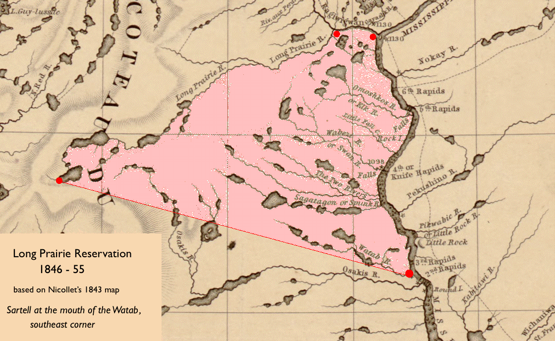
Long Prairie is a town in Todd County, Minnesota, United States. The population was 3,458 at the 2010 census. It is the county seat. and the oldest town in the County. Geography According to the United States Census Bureau, the city has a total area of ; is land and is water. The Long Prairie River, flowing North, goes through the city. Lake Charlotte borders it on the South Venewitz Creek flows from Lake Charlotte and joins the Long Prairie River in the town. U.S. Highway 71 and Minnesota State Highways 27 and 287 are three of the main routes in the city. Todd County Roads 5 and 38 originate in the town. Long Prairie has a warm-summer humid continental climate (Koppen ''Dfb'') with cold winters and generally warm summers. History Long Prairie's history dates back to the time when the land was inhabited first by the Sioux/Dakota and then Anishinaabe/ Ojibwe Native American tribes. In 1845, the U.S. government selected the location known as Long Prairie as a site f ... [...More Info...] [...Related Items...] OR: [Wikipedia] [Google] [Baidu] |
Indian Reservation
An Indian reservation is an area of land held and governed by a federally recognized Native American tribal nation whose government is accountable to the United States Bureau of Indian Affairs and not to the state government in which it is located. Some of the country's 574 federally recognized tribes govern more than one of the 326 Indian reservations in the United States, while some share reservations, and others have no reservation at all. Historical piecemeal land allocations under the Dawes Act facilitated sales to non–Native Americans, resulting in some reservations becoming severely fragmented, with pieces of tribal and privately held land being treated as separate enclaves. This jumble of private and public real estate creates significant administrative, political and legal difficulties. The total area of all reservations is , approximately 2.3% of the total area of the United States and about the size of the state of Idaho. While most reservations are sma ... [...More Info...] [...Related Items...] OR: [Wikipedia] [Google] [Baidu] |
Iowa
Iowa () is a U.S. state, state in the Midwestern United States, Midwestern region of the United States, bordered by the Mississippi River to the east and the Missouri River and Big Sioux River to the west. It is bordered by six states: Wisconsin to the northeast, Illinois to the east and southeast, Missouri to the south, Nebraska to the west, South Dakota to the northwest, and Minnesota to the north. During the 18th and early 19th centuries, Iowa was a part of Louisiana (New France), French Louisiana and Louisiana (New Spain), Spanish Louisiana; its Flag of Iowa, state flag is patterned after the flag of France. After the Louisiana Purchase, people laid the foundation for an agriculture-based economy in the heart of the Corn Belt. In the latter half of the 20th century, Iowa's agricultural economy transitioned to a diversified economy of advanced manufacturing, processing, financial services, information technology, biotechnology, and Sustainable energy, green energy productio ... [...More Info...] [...Related Items...] OR: [Wikipedia] [Google] [Baidu] |
Stockade
A stockade is an enclosure of palisades and tall walls, made of logs placed side by side vertically, with the tops sharpened as a defensive wall. Etymology ''Stockade'' is derived from the French word ''estocade''. The French word was derived from the Spanish word ''estacada''. As a frontier outpost It was used as an outpost because it provided cover and was safe to look at things through. As a security fence The troops or settlers would build a stockade by clearing a space of woodland and using the trees whole or chopped in half, with one end sharpened on each. They would dig a narrow trench around the area, and stand the sharpened logs side-by-side inside it, encircling the perimeter. Sometimes they would add additional defence by placing sharpened sticks in a shallow secondary trench outside the stockade. In colder climates sometimes the stockade received a coating of clay or mud that would make the crude wall wind-proof. Builders could also place stones or thick mud lay ... [...More Info...] [...Related Items...] OR: [Wikipedia] [Google] [Baidu] |
Fort Ripley, Minnesota
Fort Ripley is a city in Crow Wing County, Minnesota, United States, near the confluence of the Mississippi and Nokasippi Rivers. The population was 69 at the 2010 census. It is part of the Brainerd Micropolitan Statistical Area. History Fort Ripley was a United States military installation beginning in 1849 and lasting until 1877. The fort, now Camp Ripley, was on the opposite side of the Mississippi River from Morrison County as the current city in Crow Wing County. The city of Fort Ripley was incorporated in 1927. It took its name from the fort, which was named for Eleazer Wheelock Ripley, an American soldier and politician. Geography According to the United States Census Bureau, the city has a total area of , of which is land and is water. The city of Fort Ripley is geographically in Fort Ripley Township but is a separate entity. Fort Ripley is between Little Falls and Brainerd along Minnesota State Highway 371 near Over the Hill Road and Crow Wing County Roa ... [...More Info...] [...Related Items...] OR: [Wikipedia] [Google] [Baidu] |
Minnesota National Guard
The Minnesota National Guard is a state-based military force of more than 13,000 soldiers and airmen, serving in 61 communities across the state. Operated in the U.S. state of Minnesota, it is reserve component of the National Guard. The Constitution of the United States specifically charges the National Guard with dual federal and state missions. The National Guard is the only United States military force empowered to function in a state status. Those functions range from limited actions during non-emergency situations to full scale law enforcement of martial law when local law enforcement officials can no longer maintain civil control. The National Guard may be called into federal service in response to a call by the President or Congress. When National Guard troops are called to federal service, the President serves as Commander-in-Chief. The federal mission assigned to the National Guard is: "To provide properly trained and equipped units for prompt mobilization for war, ... [...More Info...] [...Related Items...] OR: [Wikipedia] [Google] [Baidu] |
Camp Ripley
Camp Ripley is a military and civilian training facility operated by the Minnesota National Guard near the city of Little Falls in the central part of the state. The location of the camp was selected in 1929 by Ellard A. Walsh, Adjutant General of the State of Minnesota. The site's winter warfare training course is the primary facility used by the National Guard for winter combat exercises. Camp Ripley also hosts the training academy for the Minnesota State Patrol and is a popular site for athletes training to compete in winter biathlons. Most Minnesota Guard soldiers train at Camp Ripley during two-week annual training periods. The camp is a state game refuge with resources managed cooperatively by the Department of Military Affairs and Department of Natural Resources. It also houses the Minnesota Military Museum, a museum that is open for the public and military personnel. Also on the grounds is the site of Fort Ripley, a military post established in 1848—the second ... [...More Info...] [...Related Items...] OR: [Wikipedia] [Google] [Baidu] |
Central Minnesota
Central Minnesota is the central part of the state of Minnesota. No definitive boundaries of the region exist, but most definitions would include the land north of Interstate 94, east of U.S. Highway 59, south of U.S. Highway 2, and west of U.S. Highway 169. Geography The northern part of the region contains many softwood forests, including the expansive Chippewa National Forest. The western and southern parts are dotted with rolling prairie, and have the region's largest agricultural operations. The region's eastern part has many hardwood and softwood forests, and once had rich iron ore deposits. The now depleted Cuyuna Range, which formed the southwestern border of the large Iron Range, was near Crosby and Ironton, at the region's eastern edge. One thing all of central Minnesota has is abundant lakes. A typical image of central Minnesota includes the many large and small lakes that surround the cities of St. Cloud (by far the region's largest city), Alexandria, Braine ... [...More Info...] [...Related Items...] OR: [Wikipedia] [Google] [Baidu] |
Historical Archaeology
Historical archaeology is a form of archaeology dealing with places, things, and issues from the past or present when written records and oral traditions can inform and contextualize cultural material. These records can both complement and conflict with the archaeological evidence found at a particular site. Studies focus on literate, historical- period societies as opposed to non-literate, prehistoric societies. While they may not have generated the records, the lives of people for whom there was little need for written records, such as the working class, slaves, indentured labourers, and children but who live in the historical period can also be the subject of study. The sites are found on land and underwater. Industrial archaeology, unless practiced at industrial sites from the prehistoric era, is a form of historical archaeology concentrating on the remains and products of industry and the Industrial era. Definition According to the overall definition given here based on meth ... [...More Info...] [...Related Items...] OR: [Wikipedia] [Google] [Baidu] |
National Register Of Historic Places
The National Register of Historic Places (NRHP) is the United States federal government's official list of districts, sites, buildings, structures and objects deemed worthy of preservation for their historical significance or "great artistic value". A property listed in the National Register, or located within a National Register Historic District, may qualify for tax incentives derived from the total value of expenses incurred in preserving the property. The passage of the National Historic Preservation Act (NHPA) in 1966 established the National Register and the process for adding properties to it. Of the more than one and a half million properties on the National Register, 95,000 are listed individually. The remainder are contributing resources within historic districts. For most of its history, the National Register has been administered by the National Park Service (NPS), an agency within the U.S. Department of the Interior. Its goals are to help property owners a ... [...More Info...] [...Related Items...] OR: [Wikipedia] [Google] [Baidu] |


