|
Fort Antes
Fort Antes was a stockade surrounding the home of Colonel John Henry Antes, built ''circa'' 1778 in Revolutionary Pennsylvania in the United States. The fort was built under the direction of Colonel Antes, who was a member of the Pennsylvania militia. It was on the east side of Antes Creek, overlooking and on the left bank of the West Branch Susquehanna River on a plateau in Nippenose Township south of modern day Jersey Shore in western Lycoming County. The local militia held the fort for a short period of time until it was ordered to abandon Fort Antes during the Big Runaway by Colonel Samuel Hunter. Despite being abandoned and attempts by the attacking British forces to burn it down, Fort Antes was one of only two structures in the valley to survive the Big Runaway. John Henry Antes John Henry Antes settled along the West Branch Susquehanna River '' circa'' 1772. His property was on the very edge of the Pennsylvania frontier. Antes’ neighbors on the north side of the Wes ... [...More Info...] [...Related Items...] OR: [Wikipedia] [Google] [Baidu] |
Nippenose Township, Lycoming County, Pennsylvania
Nippenose Township is a township in Lycoming County, Pennsylvania, United States. The population was 662 at the 2020 census. It is part of the Williamsport, Pennsylvania Metropolitan Statistical Area. History Nippenose Township was formed as part of Northumberland County in 1786 by a session of the Northumberland County court that was held in Sunbury. It became part of Lycoming County when that county was formed from Northumberland County in 1795. Nippenose Township was originally much larger than it is today, spreading over parts of what are now Clinton, Centre and Lycoming counties. The population of Nippenose Township was 588 in 1890, compared to the slightly higher population of 709 as of the 2010 census. Etymology The story behind the name of Nippenose Township is unclear. There are three competing stories. One states that it is named for the Indian phrase "Nippeno-wi", meaning a warm and genial summerlike place. The second story behind the name claims that there was an ol ... [...More Info...] [...Related Items...] OR: [Wikipedia] [Google] [Baidu] |
Fair Play Men
The Fair Play Men were illegal settlers ( squatters) who established their own system of self-rule from 1773 to 1785 in the West Branch Susquehanna River valley of Pennsylvania in what is now the United States. Because they settled in territory claimed by Native Americans, they had no recourse to the Pennsylvania colonial government. Accordingly they established what was known as the Fair Play System, with three elected commissioners who ruled on land claims and other issues for the group. In a remarkable coincidence, the Fair Play Men made their own declaration of independence from Britain on July 4, 1776 beneath the "Tiadaghton Elm" on the banks of Pine Creek. The 1768 Treaty of Fort Stanwix The British colonial government purchased land from the Iroquois in the Treaty of Fort Stanwix of 1768, opening new lands in Pennsylvania and New York for settlement, including what is now Lycoming County, Pennsylvania. Lycoming County is about 100 mi (160 km) northwest of Philad ... [...More Info...] [...Related Items...] OR: [Wikipedia] [Google] [Baidu] |
Loyalist (American Revolution)
Loyalists were colonists in the Thirteen Colonies who remained loyal to the British Crown during the American Revolutionary War, often referred to as Tories, Royalists or King's Men at the time. They were opposed by the Patriots, who supported the revolution, and called them "persons inimical to the liberties of America." Prominent Loyalists repeatedly assured the British government that many thousands of them would spring to arms and fight for the crown. The British government acted in expectation of that, especially in the southern campaigns in 1780–81. Britain was able to effectively protect the people only in areas where they had military control, and in return, the number of military Loyalists was significantly lower than what had been expected. Due to the conflicting political views, loyalists were often under suspicion of those in the British military, who did not know whom they could fully trust in such a conflicted situation; they were often looked down upon. Pat ... [...More Info...] [...Related Items...] OR: [Wikipedia] [Google] [Baidu] |
Lock Haven, Pennsylvania
Lock Haven is the county seat of Clinton County, in the U.S. state of Pennsylvania. Located near the confluence of the West Branch Susquehanna River and Bald Eagle Creek, it is the principal city of the Lock Haven Micropolitan Statistical Area, itself part of the Williamsport–Lock Haven combined statistical area. At the 2010 census, Lock Haven's population was 9,772. Built on a site long favored by pre-Columbian peoples, Lock Haven began in 1833 as a timber town and a haven for loggers, boatmen, and other travelers on the river or the West Branch Canal. Resource extraction and efficient transportation financed much of the city's growth through the end of the 19th century. In the 20th century, a light-aircraft factory, a college, and a paper mill, along with many smaller enterprises, drove the economy. Frequent floods, especially in 1972, damaged local industry and led to a high rate of unemployment in the 1980s. The city has three sites on the National Register o ... [...More Info...] [...Related Items...] OR: [Wikipedia] [Google] [Baidu] |
Pine Creek (Pennsylvania)
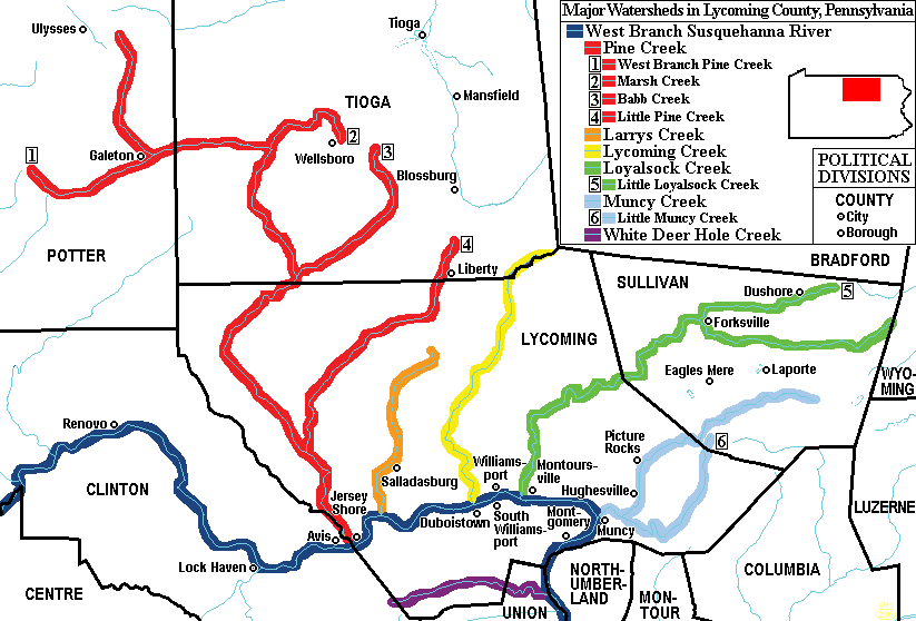
Pine Creek is a tributary of the West Branch Susquehanna River in Potter, Tioga, Lycoming, and Clinton counties in Pennsylvania. The creek is long.U.S. Geological Survey. National Hydrography Dataset high-resolution flowline dataThe National Map accessed August 8, 2011 Within Tioga County, of Pine Creek are designated as a Pennsylvania Scenic River. Pine Creek is the largest tributary of the West Branch Susquehanna River and has the largest watershed of all the West Branch’s tributaries. Name Pine Creek is named for the many pine trees that lined (and now again line) much of its banks. The Iroquois called Pine Creek ''Tiadaghton'', which according to Owlett, either meant "The River of Pines" or "The Lost or Bewildered River". Pine Creek is the largest "creek" in the United States. Geography Pine Creek's source is in Potter County, southeast of Ulysses. It flows southeast to Galeton, where it receives its first major tributary, the West Branch Pine Creek. It then ... [...More Info...] [...Related Items...] OR: [Wikipedia] [Google] [Baidu] |
Lenape
The Lenape (, , or Lenape , del, Lënapeyok) also called the Leni Lenape, Lenni Lenape and Delaware people, are an indigenous peoples of the Northeastern Woodlands, who live in the United States and Canada. Their historical territory included present-day northeastern Delaware, New Jersey and eastern Pennsylvania along the Delaware River watershed, New York City, western Long Island, and the lower Hudson Valley. Today, Lenape people belong to the Delaware Nation and Delaware Tribe of Indians in Oklahoma; the Stockbridge–Munsee Community in Wisconsin; and the Munsee-Delaware Nation, Moravian of the Thames First Nation, and Delaware of Six Nations in Ontario. The Lenape have a matrilineal clan system and historically were matrilocal. During the last decades of the 18th century, most Lenape were removed from their homeland by expanding European colonies. The divisions and troubles of the American Revolutionary War and United States' independence pushed them farther west. ... [...More Info...] [...Related Items...] OR: [Wikipedia] [Google] [Baidu] |
Wilkes-Barre, Pennsylvania
Wilkes-Barre ( or ) is a city in the U.S. state of Pennsylvania and the county seat of Luzerne County, Pennsylvania, Luzerne County. Located at the center of the Wyoming Valley in Northeastern Pennsylvania, it had a population of 44,328 in the 2020 census. It is the second-largest city, after Scranton, Pennsylvania, Scranton, in the Scranton–Wilkes-Barre–Hazleton, PA Metropolitan Statistical Area, which had a population of 563,631 as of the 2010 United States census, 2010 census and is the fourth-largest metropolitan area in Pennsylvania after the Delaware Valley, Greater Pittsburgh, and the Lehigh Valley with an urban population of 401,884. Scranton/Wilkes-Barre is the cultural and economic center of a region called Northeastern Pennsylvania, which is home to over 1.3 million residents. Wilkes-Barre and the surrounding Wyoming Valley are framed by the Pocono Mountains to the east, the Endless Mountains to the north and west, and the Lehigh Valley to the south. The Susqu ... [...More Info...] [...Related Items...] OR: [Wikipedia] [Google] [Baidu] |
Wyoming Valley
The Wyoming Valley is a historic industrialized region of Northeastern Pennsylvania. The region is historically notable for its influence in helping fuel the American Industrial Revolution with its many anthracite coal-mines. As a metropolitan area, it is known as the Scranton/Wilkes-Barre metropolitan area, after its principal cities, Scranton and Wilkes-Barre. With a population of 567,559 as of the 2020 United States census, it is the fifth-largest metropolitan area in Pennsylvania, after the Delaware Valley, Greater Pittsburgh, the Lehigh Valley, and the Harrisburg–Carlisle metropolitan statistical areas. Within the geology of Pennsylvania the Wyoming Valley makes up its own unique physiographic province, the Anthracite Valley. Greater Pittston occupies the center of the valley. Scranton is the most populated city in the metropolitan area with a population of 77,114. The city of Scranton grew in population after the 2015 mid-term census while Wilkes-Barre declined in po ... [...More Info...] [...Related Items...] OR: [Wikipedia] [Google] [Baidu] |
Connecticut
Connecticut () is the southernmost state in the New England region of the Northeastern United States. It is bordered by Rhode Island to the east, Massachusetts to the north, New York to the west, and Long Island Sound to the south. Its capital is Hartford and its most populous city is Bridgeport. Historically the state is part of New England as well as the tri-state area with New York and New Jersey. The state is named for the Connecticut River which approximately bisects the state. The word "Connecticut" is derived from various anglicized spellings of "Quinnetuket”, a Mohegan-Pequot word for "long tidal river". Connecticut's first European settlers were Dutchmen who established a small, short-lived settlement called House of Hope in Hartford at the confluence of the Park and Connecticut Rivers. Half of Connecticut was initially claimed by the Dutch colony New Netherland, which included much of the land between the Connecticut and Delaware Rivers, although the firs ... [...More Info...] [...Related Items...] OR: [Wikipedia] [Google] [Baidu] |
James Potter (Pennsylvania Politician)
James Potter (1729–1789) was a soldier, farmer, and politician from Colonial- and Revolutionary-era Pennsylvania. He rose to the rank of brigadier general of Pennsylvania militia during the Revolutionary War, and served as Vice-President of Pennsylvania, 1781–1782. Family and early life James Potter was of Scots descent, born in County Tyrone, Ireland. He came to Colonial America with his father, John Potter, in 1741, and the family settled in Cumberland County, Pennsylvania, where his father became high sheriff in 1750. His first wife was Elizabeth Cathcart of Philadelphia, and his second wife was Mary Patterson Chambers, daughter of James Patterson of Mifflin County. His daughter Martha was married to Andrew Gregg. Military career As a militia lieutenant for Northumberland County, where he made his home, James Potter took part in the Kittanning Expedition during the French and Indian War and reached the rank of lieutenant-colonel by the end of the war. He also serve ... [...More Info...] [...Related Items...] OR: [Wikipedia] [Google] [Baidu] |
Gristmill
A gristmill (also: grist mill, corn mill, flour mill, feed mill or feedmill) grinds cereal grain into flour and Wheat middlings, middlings. The term can refer to either the Mill (grinding), grinding mechanism or the building that holds it. Grist is grain that has been separated from its chaff in preparation for grinding. History Early history The Greek geographer Strabo reports in his ''Geography'' a water-powered grain-mill to have existed near the palace of king Mithradates VI Eupator at Cabira, Asia Minor, before 71 BC. The early mills had horizontal paddle wheels, an arrangement which later became known as the "Water wheel#Vertical axis, Norse wheel", as many were found in Scandinavia. The paddle wheel was attached to a shaft which was, in turn, attached to the centre of the millstone called the "runner stone". The turning force produced by the water on the paddles was transferred directly to the runner stone, causing it to grind against a stationary "Mill machinery#Wat ... [...More Info...] [...Related Items...] OR: [Wikipedia] [Google] [Baidu] |
Optical Character Recognition
Optical character recognition or optical character reader (OCR) is the electronic or mechanical conversion of images of typed, handwritten or printed text into machine-encoded text, whether from a scanned document, a photo of a document, a scene-photo (for example the text on signs and billboards in a landscape photo) or from subtitle text superimposed on an image (for example: from a television broadcast). Widely used as a form of data entry from printed paper data records – whether passport documents, invoices, bank statements, computerized receipts, business cards, mail, printouts of static-data, or any suitable documentation – it is a common method of digitizing printed texts so that they can be electronically edited, searched, stored more compactly, displayed on-line, and used in machine processes such as cognitive computing, machine translation, (extracted) text-to-speech, key data and text mining. OCR is a field of research in pattern recognition, artificial intellig ... [...More Info...] [...Related Items...] OR: [Wikipedia] [Google] [Baidu] |


