|
FNS Ruotsinsalmi
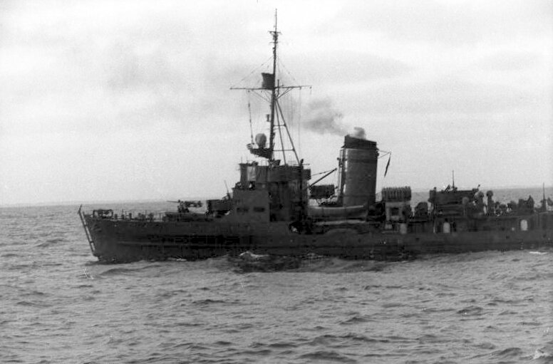
''Ruotsinsalmi'' was a minelayer of the Finnish Navy and the namesake of her class. ''Ruotsinsalmi'' was commissioned in 1940 and remained in service until 1975. The vessel was named after the battle of Ruotsinsalmi, which was fought between Sweden and Russia in 1790. New minelayers for the navy Funding for two new minelayers had been secured as early as in 1937, but instead the money was used to refurbish the garrison at Mäkiluoto. ''Ruotsinsalmi'' and her sister vessel, , were intended as escort minesweepers for the Finnish navy's coastal defence ships and , and they were therefore designed with a draught of only . ''Ruotsinsalmi'' was armed with one gun, one Bofors 40 mm guns and two Madsen 20 mm anti-aircraft cannons. The vessel had three mine dropping rails, and could carry about 100 mines. The ship could also hunt submarines, and was equipped with sonar, depth charge throwers and rails. The vessel was also strong enough to be able to tow mine sweeping equipm ... [...More Info...] [...Related Items...] OR: [Wikipedia] [Google] [Baidu] |
Draft (ship)
The draft or draught of a ship's hull is the vertical distance between the waterline and the bottom of the hull (keel). The draught of the vessel is the maximum depth of any part of the vessel, including appendages such as rudders, propellers and drop keels if deployed. Draft determines the minimum depth of water a ship or boat can safely navigate. The related term air draft is the maximum height of any part of the vessel above the water. The more heavily a vessel is loaded, the deeper it sinks into the water, and the greater its draft. After construction, the shipyard creates a table showing how much water the vessel displaces based on its draft and the density of the water (salt or fresh). The draft can also be used to determine the weight of cargo on board by calculating the total displacement of water, accounting for the content of the ship's bunkers, and using Archimedes' principle. The closely related term "trim" is defined as the difference between the forward and aft ... [...More Info...] [...Related Items...] OR: [Wikipedia] [Google] [Baidu] |
M-class Minesweeper (Germany)
The M class were the standard minesweeper (german: Minensuchboot) of Nazi Germany's ''Kriegsmarine'' during World War II. The vessels were the primary force in Germany's harbor defense command and were organized administratively into minesweeper flotillas. History M1915 and M1916 A total of 36 old units from World War I served in World War II. Some of these were converted to experimental ships, artillery school ships, fleet tenders or R-boat tenders, and 1 (ex-M109) was converted into a survey ship. In 1940, most of these converted vessels were re-designated as minesweepers again. M1935 The first series; the M1935 were ordered in the late 1930s to replace worn out World War I vintage boats. These ships proved versatile and seaworthy. The vessels could also undertake convoy escort, anti-submarine warfare and minelaying tasks as well as minesweeping. However, the ships were very expensive and complicated to build, and their oil-fired boilers meant they suffered from the fuel s ... [...More Info...] [...Related Items...] OR: [Wikipedia] [Google] [Baidu] |
Laying Mines Aboard Finnish Minelayer Ruotsinsalmi May 1942 (SA-kuva 88630)
Laying is the act of making equipment level. It usually involves moving equipment in small motions so that spirit levels are centralised in all planes. Movement is usually done by small worm gears or other fine setting devices for accurate small movements, together with coarser gears to allow large swings in motion for quick movement between different settings. Equipment that requires laying before it can be used accurately includes: * theodolites * guns and howitzers in indirect fire ( gun laying) Artillery operation Machines {{Industry-stub ... [...More Info...] [...Related Items...] OR: [Wikipedia] [Google] [Baidu] |
Helsinki
Helsinki ( or ; ; sv, Helsingfors, ) is the Capital city, capital, primate city, primate, and List of cities and towns in Finland, most populous city of Finland. Located on the shore of the Gulf of Finland, it is the seat of the region of Uusimaa in southern Finland, and has a population of . The Helsinki urban area, city's urban area has a population of , making it by far the List of urban areas in Finland by population, most populous urban area in Finland as well as the country's most important center for politics, education, finance, culture, and research; while Tampere in the Pirkanmaa region, located to the north from Helsinki, is the second largest urban area in Finland. Helsinki is located north of Tallinn, Estonia, east of Stockholm, Sweden, and west of Saint Petersburg, Russia. It has History of Helsinki, close historical ties with these three cities. Together with the cities of Espoo, Vantaa, and Kauniainen (and surrounding commuter towns, including the eastern ... [...More Info...] [...Related Items...] OR: [Wikipedia] [Google] [Baidu] |
Mohni
Mohni is an island of Estonia. It limits the Eru Bay from the north. The closest settlement at the mainland is Viinistu. Mohni is part of Lahemaa National Park. Mohni tuletorn 2011. aastal.jpg, Mohni lighthouse Mohni saar.JPG Mohni saar ja majakas 1.JPG See also * List of islands of Estonia This is an ''incomplete'' list of islands of Estonia. There are 2355 islands in total. Largest islands Incomplete list See also *List of islands in the Baltic Sea *List of islands Notes References {{Authority control Estonia ... References Islands of Estonia Kuusalu Parish {{Estonia-geo-stub ... [...More Info...] [...Related Items...] OR: [Wikipedia] [Google] [Baidu] |
Juminda
Juminda is a village in Kuusalu Parish, Harju County in northern Estonia. (retrieved 27 July 2021) It is located on the coast of the Gulf of Finland, on top of the Juminda Peninsula, on the territory of Lahemaa National Park. Juminda has a population of 35 (as of 1 January 2012). Juminda was first mentioned in 1290 as Jumentake. In the Middle Ages Juminda was inhabited by the Swedes. There's a 25 m lighthouse which was built in 1937. In August 1941, one of the deadliest naval battles in the world took place near the Juminda peninsula. It was part of the Soviet evacuation of Tallinn when the Soviets planned to evacuate parts of the Baltic Fleet from Tallinn to Leningrad but were stopped by a 32 km long strip of mines placed by the Germans and Finns. The convoys consisted of a few hundred ships, some of them being passenger ships carrying Estonia Estonia, formally the Republic of Estonia, is a country by the Baltic Sea in Northern Europe. It is bordered to ... [...More Info...] [...Related Items...] OR: [Wikipedia] [Google] [Baidu] |
Osmussaar
Osmussaar ( sv, Odensholm, german: Odinsholm) is an Estonian island situated in the mouth of the Gulf of Finland in the Baltic Sea, 7.5 km off the Estonian mainland. Administratively the island is part of Lääne-Nigula Parish in Lääne County. Its area is . Before the Soviet Union occupied Estonia during World War II, around 130 people, mainly Estonian Swedes, lived on the island. The continuous settlement of Swedes on Osmussaar had dated back for centuries. Currently Osmussaar has only two permanent inhabitants and the island is a nature reserve. Name The island's Swedish name ''Odensholm'' (or ''Odinsholm'') derives from the Vikings' chief god, Odin, who, according to a legend, is buried on the island. The origin of the Estonian name ''Osmussaar'' is not clear. History The continuous settlement of Estonian Swedes on Osmussaar, which lasted until World War II, goes back at least to the 14th century, though little is known of the island's history before the 18th cen ... [...More Info...] [...Related Items...] OR: [Wikipedia] [Google] [Baidu] |
Paldiski
Paldiski is a town and Baltic Sea port situated on the Pakri Peninsula of northwestern Estonia. Since 2017, it's the administrative centre of Lääne-Harju Parish of Harju County. Previously a village of Estonia-Swedes known by the historical name ''Rågervik'', it was extended into a Russian naval base in the 18th century. The Russian authorities renamed it ''Балтийский Порт'' ("Baltiyskiy Port", i.e., Baltic Port, german: Baltisch-Port) in 1762. In written Estonian, the name was spelled ''Baltiski'' until 1933, when the phonetically spelled version ''Paldiski'' became official. History Swedish Empire Paldiski was founded as a fishing village by Estonian Swedes with the name Rågervik. Russian Empire Peter the Great chose the location in 1715 for a naval base, and construction started in 1716. It was meant to be a sea fortress and in 1790, during the Russo-Swedish War, it was conquered by the Swedes through trickery, when a Swedish warship sailing un ... [...More Info...] [...Related Items...] OR: [Wikipedia] [Google] [Baidu] |
Hanko, Finland
Hanko (; sv, Hangö) is a port town and municipality on the south coast of Finland, west of Helsinki. Its current population is (). The town is bilingual, with a majority being Finnish speakers and a strong minority being Swedish speakers (). The skyline of Hanko is dominated by the church and the water tower. Both of them received their current appearance after World War II, as their predecessors were either damaged or destroyed by the Soviet Armed Forces. Geography The Hanko Peninsula, on which the city is located, is the southernmost tip of continental Finland. The soil is a sandy moraine, and vegetation consists mainly of pine and low shrubs, mostly ''Calluna''. Hanko is known for its beautiful archipelago. The town has a coastline of approximately , of which are sandy beaches. There are also over 90 small islands and islets within the city limits. Climate Hanko has a humid continental climate (Köppen ''Dfb''), similar to other locations in southern Finland with ... [...More Info...] [...Related Items...] OR: [Wikipedia] [Google] [Baidu] |
Continuation War
The Continuation War, also known as the Second Soviet-Finnish War, was a conflict fought by Finland and Nazi Germany against the Soviet Union from 1941 to 1944, as part of World War II.; sv, fortsättningskriget; german: Fortsetzungskrieg. According to Finnish historian Olli Vehviläinen, the term 'Continuation War' was created at the start of the conflict by the Finnish government, to justify the invasion to the population as a continuation of the defensive Winter War and separate from the German war effort. He titled the chapter addressing the issue in his book as "Finland's War of Retaliation". Vehviläinen asserted that the reality of that claim changed when the Finnish forces crossed the 1939 frontier and started annexation operations. The US Library of Congress catalogue also lists the variants War of Retribution and War of Continuation (see authority control)., group="Note" In Soviet historiography, the war was called the Finnish Front of the Great Patriotic War.. Alter ... [...More Info...] [...Related Items...] OR: [Wikipedia] [Google] [Baidu] |
Gulf Of Finland
The Gulf of Finland ( fi, Suomenlahti; et, Soome laht; rus, Фи́нский зали́в, r=Finskiy zaliv, p=ˈfʲinskʲɪj zɐˈlʲif; sv, Finska viken) is the easternmost arm of the Baltic Sea. It extends between Finland to the north and Estonia to the south, to Saint Petersburg in Russia to the east, where the river Neva drains into it. Other major cities around the gulf include Helsinki and Tallinn. The eastern parts of the Gulf of Finland belong to Russia, and some of Russia's most important oil harbors are located farthest in, near Saint Petersburg (including Primorsk). As the seaway to Saint Petersburg, the Gulf of Finland has been and continues to be of considerable strategic importance to Russia. Some of the environmental problems affecting the Baltic Sea are at their most pronounced in the shallow gulf. Proposals for a tunnel through the gulf have been made. Geography The gulf has an area of . The length (from the Hanko Peninsula to Saint Petersburg) is and t ... [...More Info...] [...Related Items...] OR: [Wikipedia] [Google] [Baidu] |


