|
Furna (Brava)
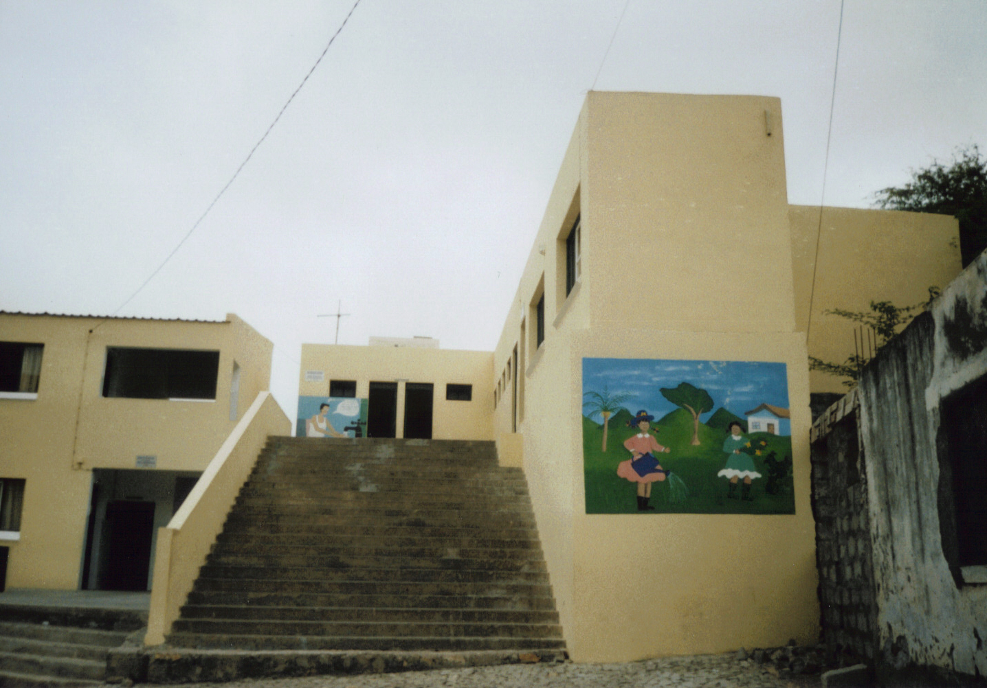
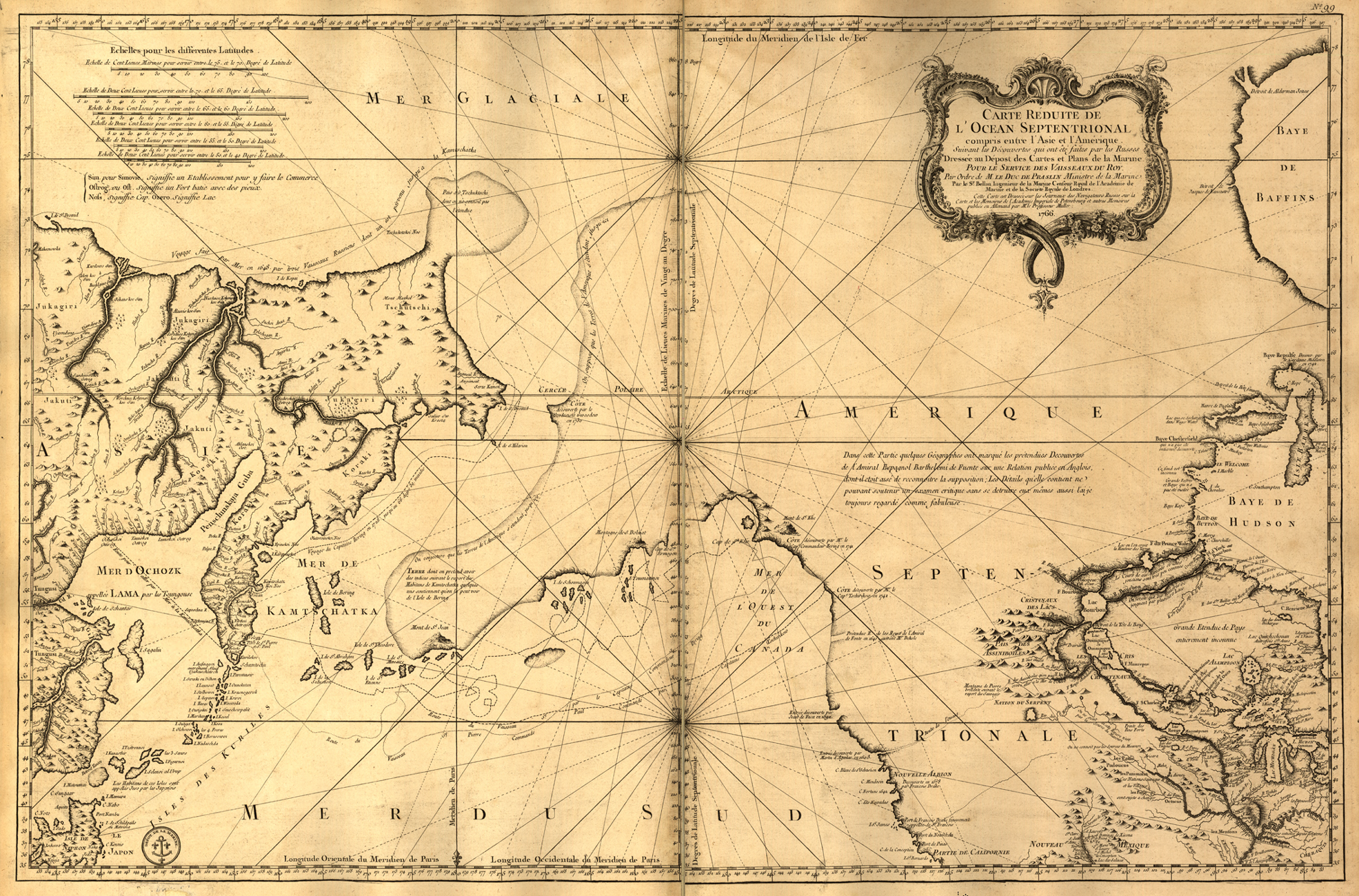
Furna is a seaside community in the northeastern part of the island of Brava, Cape Verde. It lies 2.5 km northeast of the island capital of Nova Sintra. At the 2010 census its population was 612. About the village The settlement was mentioned as ''Fuurno'' in the 1747 map by Jacques-Nicolas Bellin. Furna became the most important harbour of Brava in 1843. In 1982, many boats and some houses of Furna were destroyed by waves reaching a height of up to 10 meters which were caused by the tropical storm ''Beryl''. The harbour was improved in 2000. There are ferry connections to São Filipe in Fogo and Praia in Santiago. Brava has a chapel known as Nossa Senhora de Boa Viagem. The new yellow school near the small church in the South of the village, which was paid by the government of Belgium, has large wall paintings motivating the children to save as much water as possible and to help keeping the island green. Less than a kilometer northeast of Furna is the headland Ponta J ... [...More Info...] [...Related Items...] OR: [Wikipedia] [Google] [Baidu] |
Brava, Cape Verde
Brava ( Portuguese for "wild" or "brave") is an island in Cape Verde, in the Sotavento group. At , it is the smallest inhabited island of the Cape Verde archipelago, but at the same time the greenest. First settled in the early 16th century, its population grew after Mount Fogo on neighbouring Fogo erupted in 1680. For more than a century, its main industry was whaling, but the island economy is now primarily agricultural. History Brava was discovered in 1462 by the Portuguese explorer Diogo Afonso.Valor simbólico do centro histórico da Praia Lourenço Conceição Gomes, Universidade Portucalense, 2008, p. 97 There is no evidence of human presence on the Cape Verde islands before the arrival of the Portuguese. Around 1620 the population of Brava started with the arrival of settlers from |
Cape Verde
, national_anthem = () , official_languages = Portuguese , national_languages = Cape Verdean Creole , capital = Praia , coordinates = , largest_city = capital , demonym = Cape Verdean or Cabo Verdean , ethnic_groups_year = 2017 , government_type = Unitary semi-presidential republic , leader_title1 = President , leader_name1 = José Maria Neves , leader_title2 = Prime Minister , leader_name2 = Ulisses Correia e Silva , legislature = National Assembly , area_rank = 166th , area_km2 = 4033 , area_sq_mi = 1,557 , percent_water = negligible , population_census = 561,901 , population_census_rank = 172nd , population_census_year = 2021 , population_density_km2 = 123.7 , population_density_sq_mi = 325.0 , population_density_rank = 89th , GDP_PPP ... [...More Info...] [...Related Items...] OR: [Wikipedia] [Google] [Baidu] |
Nova Sintra
Nova Sintra is a cityCabo Verde, Statistical Yearbook 2015 , , p. 32-33 in the central part of the island of Brava in southwestern . It serves as the seat of the Brava Municipality. The settlement is named after |
Jacques-Nicolas Bellin
Jacques Nicolas Bellin (1703 – 21 March 1772) was a French hydrographer, geographer, and member of the French intellectual group called the philosophes. Bellin was born in Paris. He was hydrographer of France's hydrographic office, member of the ''Académie de Marine'' and of the Royal Society of London. Over a 50-year career, he produced many maps of particular interest to the ''Ministère de la Marine''. His maps of Canada and of French territories in North America ( New France, Acadia, Louisiana) are particularly valuable. He died at Versailles. First ''Ingenieur de la Marine'' In 1721, at age 18, he was appointed hydrographer (chief cartographer) to the French Navy. In August 1741, he became the first ''Ingénieur de la Marine of the Dépot des cartes et plans de la Marine'' (the French Hydrographical Office) and was named Official Hydrographer of the French King. Prodigious work, high standard of excellence During his reign the Depot published a prodigious numbe ... [...More Info...] [...Related Items...] OR: [Wikipedia] [Google] [Baidu] |
1982 Atlantic Hurricane Season
The 1982 Atlantic hurricane season was an extremely inactive Atlantic hurricane season with five named tropical storms and one subtropical storm. Two storms became hurricanes, one of which reached major hurricane status. The season officially began on June 1, 1982, and lasted until November 30, 1982. These dates conventionally delimit the period of each year when most tropical cyclones form in the Atlantic basin. Activity started early with Hurricane Alberto forming on the first day of the season. Alberto threatened the Southwestern Florida coast as a tropical storm, meadering offshore in the southeastern Gulf of Mexico and causing 23 fatalities in Cuba. The next system, a subtropical storm, formed later in June and affected the same area as Alberto, causing $10 million in damage. Tropical Storm Beryl formed on August 28, after a quiet July in the open Atlantic Ocean. Beryl grazed Cape Verde, killing 3 people. Tropical Depression Three formed just behind Beryl, tracki ... [...More Info...] [...Related Items...] OR: [Wikipedia] [Google] [Baidu] |
Praia
Praia (, Portuguese for "beach") is the capital and largest city of Cape Verde.Cape Verde, Statistical Yearbook 2015 Instituto Nacional de Estatística Located on the southern coast of Santiago island, within the group, the city is the seat of the Praia Mun ... [...More Info...] [...Related Items...] OR: [Wikipedia] [Google] [Baidu] |
Santiago, Cape Verde
Santiago ( Portuguese for “Saint James”) is the largest island of Cape Verde, its most important agricultural centre and home to half the nation's population. Part of the Sotavento Islands, it lies between the islands of Maio ( to the east) and Fogo ( to the west). It was the first of the islands to be settled: the town of Ribeira Grande (now Cidade Velha and a UNESCO World Heritage Site) was founded in 1462. Santiago is home to the nation's capital city of Praia. History The eastern side of the nearby island of Fogo collapsed into the ocean 73,000 years ago, creating a tsunami 170 meters high which struck Santiago. In 1460, António de Noli became the first to visit the island. Da Noli settled at ''Ribeira Grande'' (now Cidade Velha) with his family members and Portuguese from Algarve and Alentejo in 1462.Valor simb ... [...More Info...] [...Related Items...] OR: [Wikipedia] [Google] [Baidu] |
Ponta Jalunga
Ponta Jalunga is a headland located nearly a kilometer northeast of the port of Furna on the island of Brava in southwestern Cape Verde. It is the northeasternmost point of the island. The promontory is a rocky area, up to 120 meters high. The headland was mentioned as ''Pt. Ghelongo'' in the 1747 map by Jacques-Nicolas Bellin. Ponta Jalunga Lighthouse The lighthouse at Ponta Jalunga was constructed in 1891. It is a white masonry tower. It is 8 metres tall and its focal height is at 26 metres above sea level. Its range extends to and its light source as with many other lighthouses is solar powered. See also *List of lighthouses in Cape Verde The following article is a list of lighthouses in Cape Verde. Cape Verde has tens of lighthouses scattered across its nine major islands. The lighthouses are administered by the Direction of Marine and Ports (''Direcção Geral de Marinha e Portos' ... References {{DEFAULTSORT:Jalunga Geography of Brava, Cape Verde Jalunga Lig ... [...More Info...] [...Related Items...] OR: [Wikipedia] [Google] [Baidu] |
List Of Villages And Settlements In Cape Verde
This is a list of villages and smaller settlements in Cape Verde: Boa Vista * Bofarreira * Cabeça dos Tarrafes * Curral Velho - abandoned settlement * Espingueira - abandoned settlement * Estância de Baixo * Fundo das Figueiras * João Galego * Povoação Velha * Prazeres - abandoned settlement Brava * Cachaço * Campo Baixo * Cova Joana * Cova Rodela * Fajã de Água * João da Noly * Lem * Mato * Mato Grande * Nossa Senhora do Monte * Santa Bárbara * Tantum * Tomé Barraz * Vinagre Fogo * Achada Furna * Achada Grande * Atalaia * Cabeça Fundão * Campanas Baixo * Chã das Caldeiras * Corvo * Curral Grande * Estância Roque * Fajãzinha * Feijoal * Figueira Pavão * Fonte Aleixo * Galinheiro * As Hortas * Lagariça * Lomba * Miguel Gonçalves * Monte Grande * Patim * Ponta Verde * Relva * Ribeira do Ilhéu * Salto * Santo António * São Filipe * São Jorge * Tinteira * Vicente Dias Maio * Alcatraz * Barreiro * Calheta * Cascabu ... [...More Info...] [...Related Items...] OR: [Wikipedia] [Google] [Baidu] |
Villages And Settlements In Brava, Cape Verde
A village is a clustered human settlement or community, larger than a hamlet but smaller than a town (although the word is often used to describe both hamlets and smaller towns), with a population typically ranging from a few hundred to a few thousand. Though villages are often located in rural areas, the term urban village is also applied to certain urban neighborhoods. Villages are normally permanent, with fixed dwellings; however, transient villages can occur. Further, the dwellings of a village are fairly close to one another, not scattered broadly over the landscape, as a dispersed settlement. In the past, villages were a usual form of community for societies that practice subsistence agriculture, and also for some non-agricultural societies. In Great Britain, a hamlet earned the right to be called a village when it built a church. [...More Info...] [...Related Items...] OR: [Wikipedia] [Google] [Baidu] |
Populated Coastal Places In Cape Verde
Population typically refers to the number of people in a single area, whether it be a city or town, region, country, continent, or the world. Governments typically quantify the size of the resident population within their jurisdiction using a census, a process of collecting, analysing, compiling, and publishing data regarding a population. Perspectives of various disciplines Social sciences In sociology and population geography, population refers to a group of human beings with some predefined criterion in common, such as location, race, ethnicity, nationality, or religion. Demography is a social science which entails the statistical study of populations. Ecology In ecology, a population is a group of organisms of the same species who inhabit the same particular geographical area and are capable of interbreeding. The area of a sexual population is the area where inter-breeding is possible between any pair within the area and more probable than cross-breeding with ... [...More Info...] [...Related Items...] OR: [Wikipedia] [Google] [Baidu] |


