|
Foster, Ohio
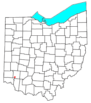
Fosters (sometimes given as Foster) is an unincorporated community in southern Warren County, Ohio, United States. It straddles the Little Miami River in Deerfield and Hamilton Townships. It is located about two miles southwest of Hopkinsville, two miles west of Maineville, and two miles northeast of Twenty Mile Stand just off U.S. Route 22/ State Route 3, the 3C Highway. (In the 1930s, the State of Ohio erected a new high bridge over the river that bypassed the community.) The community is in the Kings Local School District and is served by the Maineville post office. The settlement was originally called ''Foster's Crossing''. The community was named after the local Foster family. The Little Miami Bike Trail, which runs from Milford to Spring Valley, runs through the community on the eastern shore of the Little Miami River. Arts and culture The Monkey Bar and Grille, also known as the Train Stop Inn, is located on the east side of the Little Miami River and was once a thr ... [...More Info...] [...Related Items...] OR: [Wikipedia] [Google] [Baidu] |
Ohio State Route 3
State Route 3 (SR 3) is a major north–south (physically northeast-southwest) highway in Ohio which leads from Cincinnati to Cleveland by way of Columbus. It is the second longest state route in Ohio. Because of this, the road is also known as the 3-C Highway, a designation which predates the Ohio state highway system. It is the only state route to enter all three of Ohio's largest cities, though it has largely been bypassed by Interstate 71 (I-71). The route's southern terminus is in downtown Cincinnati at the U.S. Route 27 (US 27)/US 52/US 127 concurrency, which is also the western terminus of US 22. SR 3 and US 22 share the same path for nearly , parting ways in the city of Washington Court House, where SR 3 is joined with US 62. This concurrency runs nearly to Columbus. From there, SR 3 continues solo to Sunbury, where it joins US 36 for just over until it reaches Mount Vernon. SR 3 ends in Cleveland at Public Square, with the last several miles concurre ... [...More Info...] [...Related Items...] OR: [Wikipedia] [Google] [Baidu] |
Fort Ancient
Fort Ancient is a name for a Native American culture that flourished from Ca. 1000-1750 CE and predominantly inhabited land near the Ohio River valley in the areas of modern-day southern Ohio, northern Kentucky, southeastern Indiana and western West Virginia. Although a contemporary of the Mississippian culture, they are often considered a "sister culture" and distinguished from the Mississippian culture. Although far from agreed upon, there is evidence to suggest that the Fort Ancient Culture were not the direct descendants of the Hopewellian Culture. It is suspected that the Fort Ancient Culture introduced maize agriculture to Ohio. The Fort Ancient Culture were most likely the builders of the Great Serpent Mound. Name The name of the culture originates from the Fort Ancient, Ohio archeological site. However, the Fort Ancient Site is now thought to have been built by Ohio Hopewellian people. It was likely occupied later by the succeeding Fort Ancient culture. The site is loc ... [...More Info...] [...Related Items...] OR: [Wikipedia] [Google] [Baidu] |
Hopewell Culture
The Hopewell tradition, also called the Hopewell culture and Hopewellian exchange, describes a network of precontact Native American cultures that flourished in settlements along rivers in the northeastern and midwestern Eastern Woodlands from 100 BCE to 500 CE, in the Middle Woodland period. The Hopewell tradition was not a single culture or society but a widely dispersed set of populations connected by a common network of trade routes. At its greatest extent, the Hopewell exchange system ran from the northern shores of Lake Ontario south to the Crystal River Indian Mounds in modern-day Florida. Within this area, societies exchanged goods and ideas, with the highest amount of activity along waterways, which were the main transportation routes. Peoples within the Hopewell exchange system received materials from all over the territory of what now comprises the mainland United States. Most of the items traded were exotic materials; they were delivered to peoples living in the maj ... [...More Info...] [...Related Items...] OR: [Wikipedia] [Google] [Baidu] |
Frederick Ward Putnam
Frederic Ward Putnam (April 16, 1839 – August 14, 1915) was an American anthropologist and biologist. Biography Putnam was born and raised in Salem, Massachusetts, the son of Ebenezer (1797–1876) and Elizabeth (Appleton) Putnam. After leaving college, Ebenezer had for a short time engaged in fitting young men for college, but soon went into business in Cincinnati as a commission merchant, a line in which he was successful. Recalled to Salem by his father's death in 1826, Ebenezer married there and devoted himself to the study and cultivation of plants and fruits, and involved himself in the Democratic Party in his county. Although frequently offered office, Ebenezer never accepted, except to serve as alderman in the so-called “model-government” of Salem when that town was first chartered as a city, and as postmaster of Salem.''The Cyclopædia of American Biography'', 1918 Frederic's early studies were at private schools, and with his father at home. He became curator of or ... [...More Info...] [...Related Items...] OR: [Wikipedia] [Google] [Baidu] |
Little Miami Railroad
The Little Miami Railroad was a railway of southwestern Ohio, running from the eastern side of Cincinnati to Springfield, Ohio. By merging with the Columbus and Xenia Railroad in 1853, it created the first through-rail route from the important manufacturing city of Cincinnati to the state capital, Columbus, Ohio, Columbus. In this period, railroads were important for creating connections between the important waterways of the Great Lakes and the Ohio River, which were major transportation routes for products to other markets. The LMRR's importance declined later in the 19th century, after three major railroads from the East built lines across the Allegheny Mountains and established east–west transportation systems through the state. It continued independent operations until 1981, after being absorbed by Conrail during the period of extensive railroad restructuring in the late 20th century. History The Little Miami was incorporated on March 11, 1836. Its first president, who se ... [...More Info...] [...Related Items...] OR: [Wikipedia] [Google] [Baidu] |
Spring Valley, Ohio
Spring Valley is a village in Greene County, Ohio, United States. The population was 415 at the 2020 census. It is part of the Dayton Metropolitan Statistical Area. History Spring Valley had its start in the early 1840s by the building of the Little Miami Railroad through that territory. The town was platted in 1844. Geography Spring Valley is located at (39.608533, -84.007257). According to the United States Census Bureau, the village has a total area of , all of it land. Demographics 2010 census As of the census of 2010, there were 479 people, 198 households, and 136 families living in the village. The population density was . There were 221 housing units at an average density of . The racial makeup of the village was 97.3% White, 0.2% African American, 0.2% Native American, 0.2% from other races, and 2.1% from two or more races. Hispanic or Latino of any race were 0.8% of the population. There were 198 households, of which 26.8% had children under the age of 18 living ... [...More Info...] [...Related Items...] OR: [Wikipedia] [Google] [Baidu] |
Milford, Ohio
Milford is a city in Clermont and Hamilton counties founded in 1796, in the U.S. state of Ohio, along the Little Miami River and its East Fork in the southwestern part of the state. It is a part of the Greater Cincinnati metropolitan area. The population was 6,710 at the 2010 census. History Nancarrow and Hageman "No wonder, then, that it struck with rapture the quaint and eccentric John Nancarrow, who had it surveyed for him on May 28, 1788 as Dutch burgomaster intended to found a city that should become the future metropolis of the West" (Louis Everts, 1880, p. 473). The area within Milford, Old Milford, and O'Bannon Township were all built on a survey by John Nancarrow, a Revolutionary War veteran from Virginia. O'Bannon, now Miami, Township was named for Clermont's first surveyor. A field along Gatch Avenue on what was once the farm of John Gatch has yielded large numbers of artifacts for several generations; it is now believed to have been the site of a Native America ... [...More Info...] [...Related Items...] OR: [Wikipedia] [Google] [Baidu] |
Little Miami Bike Trail
The Little Miami Scenic Trail is the fourth longest paved trail in the United States, running through five southwestern counties in the state of Ohio. The multi-use rail trail sees heavy recreational use by hikers and bicyclists, as well as the occasional horseback rider. Over 700,000 people made use of the trail in 2014. Most of the trail runs along the banks of the Little Miami River, in a dedicated, car-free corridor known as Little Miami State Park. This unusually linear state park passes through four counties, with a right-of-way running about long and averaging in width for a total of about . Elsewhere, the corridor ranges from in width. The Little Miami Scenic Trail is signposted as State Bike Route 1 south of Xenia and State Bike Route 3 throughout. It is the backbone of a nearly continuous network of paved multi-use trails, centered on the Miami Valley area, that stretches and connects the Cincinnati, Dayton, and Columbus metropolitan areas. The Little Miami trail ... [...More Info...] [...Related Items...] OR: [Wikipedia] [Google] [Baidu] |
Twenty Mile Stand, Ohio
Twenty Mile Stand is an unincorporated community in southeastern Deerfield Township, Warren County, Ohio, United States. It lies on the old 3C Highway in Town 4 East, Range 2 North, Section 21 of the Symmes Purchase and in the center of the area known as "Landen". It is about three miles south-south west of Kings Mills, two miles southwest of Fosters, and twenty miles northeast of Cincinnati Cincinnati ( ) is a city in the U.S. state of Ohio and the county seat of Hamilton County. Settled in 1788, the city is located at the northern side of the confluence of the Licking and Ohio rivers, the latter of which marks the state line wit .... A post office called Twenty Mile Stand was established in 1819, the name was changed to Twentymile Stand in 1895, and the post office closed in 1904. In the 19th century, the town was a stagecoach stop from downtown Cincinnati, hence the name. In April 2013, the original stagecoach stop, known as the Twenty Mile House, was demolished an ... [...More Info...] [...Related Items...] OR: [Wikipedia] [Google] [Baidu] |
Unincorporated Area
An unincorporated area is a region that is not governed by a local municipal corporation. Widespread unincorporated communities and areas are a distinguishing feature of the United States and Canada. Most other countries of the world either have no unincorporated areas at all or these are very rare: typically remote, outlying, sparsely populated or List of uninhabited regions, uninhabited areas. By country Argentina In Argentina, the provinces of Chubut Province, Chubut, Córdoba Province (Argentina), Córdoba, Entre Ríos Province, Entre Ríos, Formosa Province, Formosa, Neuquén Province, Neuquén, Río Negro Province, Río Negro, San Luis Province, San Luis, Santa Cruz Province, Argentina, Santa Cruz, Santiago del Estero Province, Santiago del Estero, Tierra del Fuego Province, Argentina, Tierra del Fuego, and Tucumán Province, Tucumán have areas that are outside any municipality or commune. Australia Unlike many other countries, Australia has only local government in Aus ... [...More Info...] [...Related Items...] OR: [Wikipedia] [Google] [Baidu] |
Maineville, Ohio
Maineville is a village in Warren County, Ohio, United States. The population was 975 at the 2010 census. History Maineville was incorporated as a village on March 23, 1850. The village derives its name from Maine, the native state of a large share of its first settlers.The settlers came mostly from the Maine town of Phillips; and some from nearby Farmington. Originally, the relocation of these people involved nearly one hundred families (the relocation took 30 to 60 days). The town was called "Yankeetown" and "Maineville", and in 1850 it was incorporated as "Maineville". A village flag was designed and created by John Michael, later to become Mayor of Maineville. The flag includes Ohio and Maine, the state seals and a connecting reference to the two areas. The flag was adopted unanimously by the Maineville Council in 1994. A post office was established at Maineville in 1854. Geography Maineville is located at (39.316998, -84.222924). According to the United States Census Bureau ... [...More Info...] [...Related Items...] OR: [Wikipedia] [Google] [Baidu] |


