|
Flinders Council
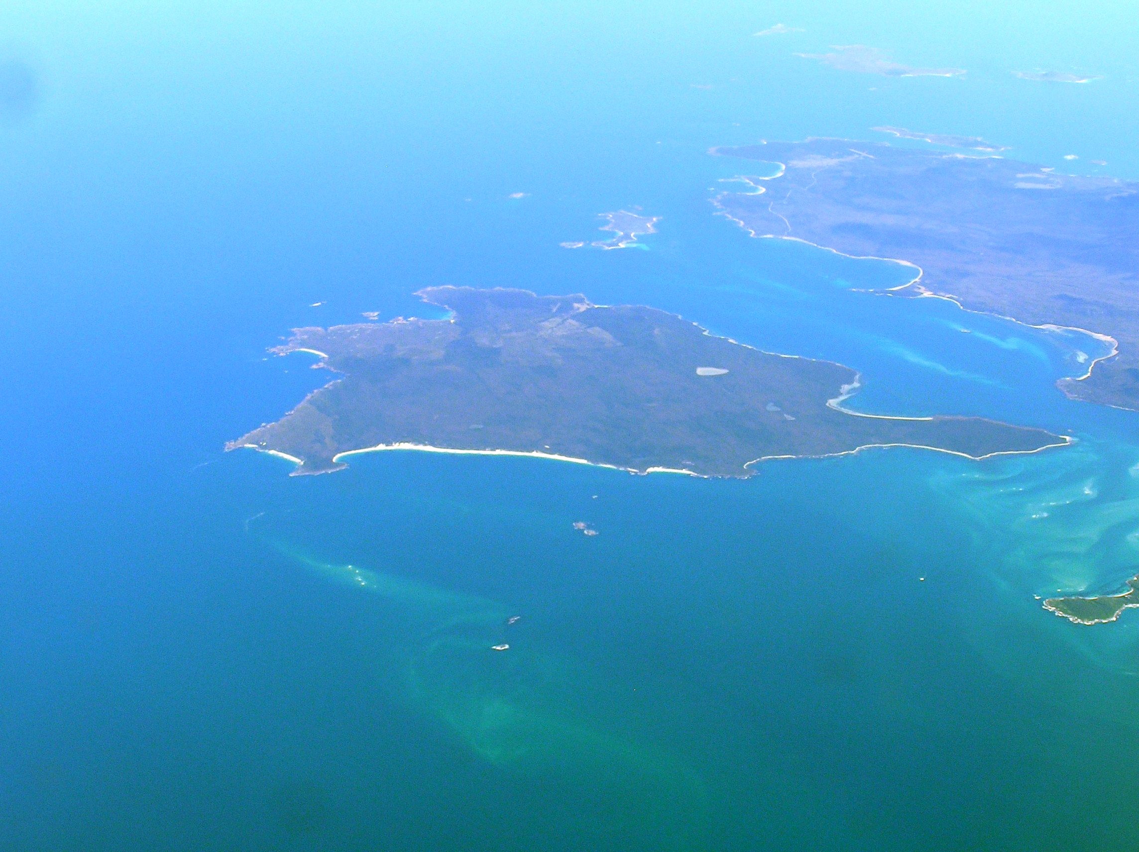
Flinders Council is a local government body in Tasmania, encompassing the Furneaux Group and nearby islands of Bass Strait, in the north-east of the state. Flinders is classified as a rural local government area and has a population of 987, with Whitemark the main town located on Flinders Island. History and attributes The municipality was established on 1 January 1907. Flinders is classified as rural, agricultural and small under the Australian Classification of Local Governments. Geography Flinders covers more than 60 islands off the north-eastern tip of Tasmania at the eastern end of Bass Strait. Of these 60, 12 have permanent populations. The bigger ones are Clarke Island, Cape Barren Island, and the largest and most populous, Flinders Island. The Flinders Council includes the Furneaux Group together with the groups of islands to the north west including Kent Group, Hogan Island Group, Curtis Group, and the Wilsons Promontory Tasmanian Islands ( Rodondo, West Moncoeur ... [...More Info...] [...Related Items...] OR: [Wikipedia] [Google] [Baidu] |
Australian Bureau Of Statistics
The Australian Bureau of Statistics (ABS) is the independent statutory agency of the Australian Government responsible for statistical collection and analysis and for giving evidence-based advice to federal, state and territory governments. The ABS collects and analyses statistics on economic, population, environmental and social issues, publishing many on their website. The ABS also operates the national Census of Population and Housing that occurs every five years. History In 1901, statistics were collected by each state for their individual use. While attempts were made to coordinate collections through an annual Conference of Statisticians, it was quickly realized that a National Statistical Office would be required to develop nationally comparable statistics. The Commonwealth Bureau of Census and Statistics (CBCS) was established under the Census and Statistics Act in 1905. Sir George Knibbs was appointed as the first Commonwealth Statistician. Initially, the bureau w ... [...More Info...] [...Related Items...] OR: [Wikipedia] [Google] [Baidu] |
Clarke Island (Tasmania)
The Clarke Island (also known by its Indigenous name of ''Lungtalanana Island''), part of the Furneaux Group, is an island in Bass Strait, south of Cape Barren Island, about off the northeast coast of Tasmania, Australia. Banks Strait separates the island from Cape Portland on the mainland. Off its west coast lies the shipwreck of ''HMS Litherland'', which sank in 1853 and was discovered in 1983. Clarke Island is Tasmania's eighth largest island. History Clarke Island/Lungtalanana was uninhabited prior to European settlement. ''Sydney Cove'' ran aground between Preservation Island and Rum Island on 28 February 1797.Nash, M.Maritime Archaeology Monograph and Reports Series No.2 - Investigation of a Survivors Camp from the Sydney Cove Shipwreck." Master of Maritime Archaeology Thesis. Department of Archaeology, Flinders University, South Australia. 2004. Accessed 30 December 2009. A party of seventeen men set off on 28 February 1787 in the ship's longboat to reach help at Port ... [...More Info...] [...Related Items...] OR: [Wikipedia] [Google] [Baidu] |
East Moncoeur Island
East Moncoeur Island is a granite island, with an area of 14 ha. It is part of Tasmania’s Rodondo Group, lying in northern Bass Strait south of Wilsons Promontory in Victoria, in south-eastern Australia. The island was sighted by Lieutenant James Grant on 9 December 1800 from the survey brig HMS Lady Nelson and named after ''"Captain Moncur of the Royal navy"''. Fauna Recorded breeding seabird and wader species include little penguin, short-tailed shearwater, fairy prion, common diving-petrel, Pacific gull, silver gull and sooty oystercatcher. The island is part of the Wilsons Promontory Islands Important Bird Area, identified as such by BirdLife International because of its importance for breeding seabirds. Reptiles present include the metallic skink, Bougainville's skink and White's skink White's skink (''Liopholis whitii)'', also known commonly as White's rock skink, is a species of lizard in the family Scincidae. The species is endemic to Australia. Etymolog ... [...More Info...] [...Related Items...] OR: [Wikipedia] [Google] [Baidu] |
West Moncoeur Island
West Moncoeur Island is a granite island, ringed by steep cliffs, with an area of 9.18 ha, in south-eastern Australia. It is part of Tasmania’s Rodondo Group, lying in northern Bass Strait south of Wilsons Promontory in Victoria. It is a nature reserve. The island was sighted by Lieutenant James Grant on 9 December 1800 from the survey brig HMS ''Lady Nelson'' and named after "Captain Moncur of the Royal navy". Fauna Recorded breeding seabird and wader species include short-tailed shearwater, fairy prion, common diving-petrel, Pacific gull, and sooty oystercatcher. The island is part of the Wilsons Promontory Islands Important Bird Area, identified as such by BirdLife International because of its importance for breeding seabirds. The metallic skink is present. The island holds an important breeding colony of Australian fur seal The brown fur seal (''Arctocephalus pusillus''), also known as the Cape fur seal, South African fur seal and Australian fur seal, is a spe ... [...More Info...] [...Related Items...] OR: [Wikipedia] [Google] [Baidu] |
Rodondo Island
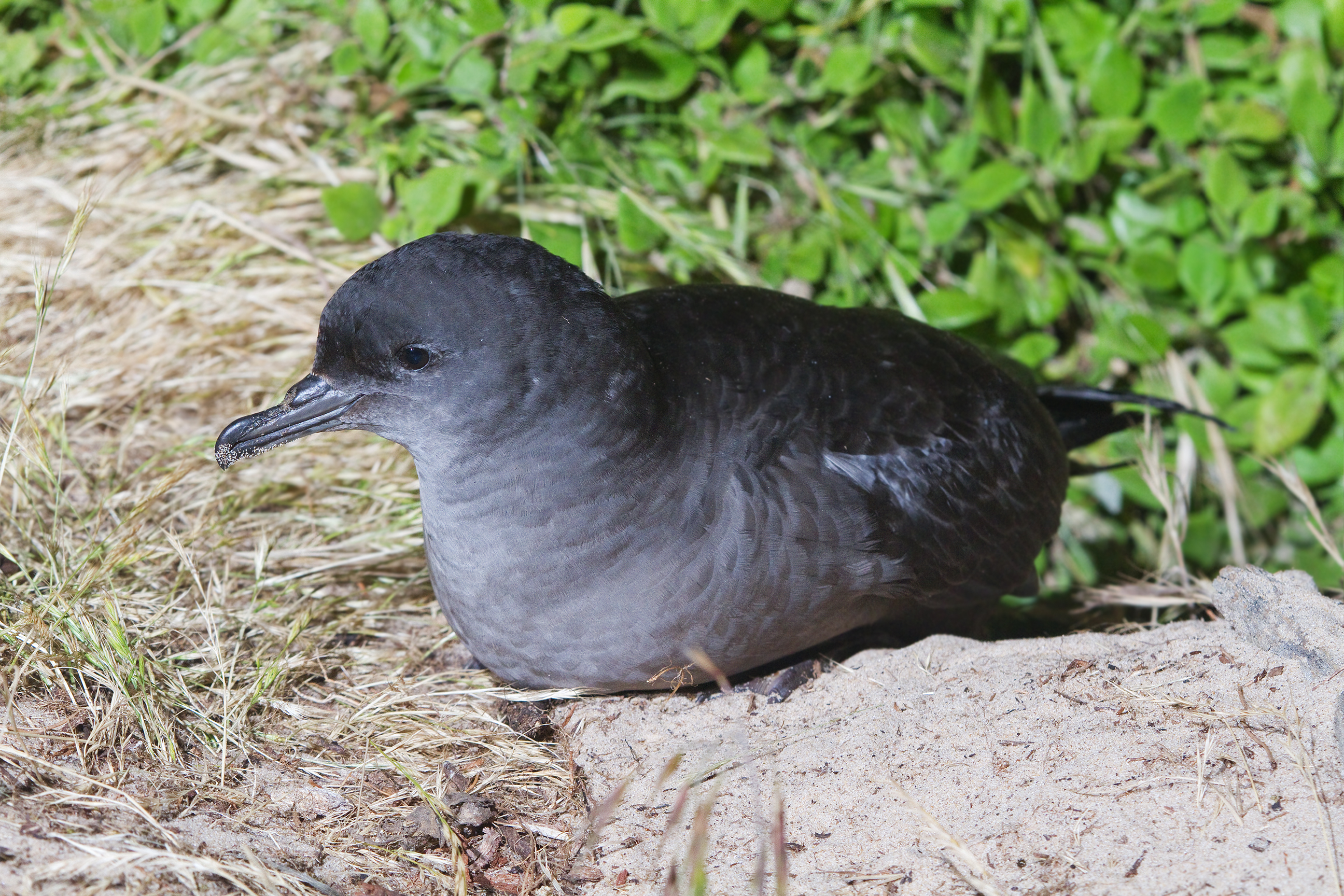
Rodondo Island is a granite island, part of the Rodondo Group, lying in northern Bass Strait, within the state boundaries of Tasmania, Australia. The island is located only south of Wilsons Promontory in Victoria, and 2' of latitude () south of the Victoria-Tasmania border at latitude 39°12'S. Rodondo Island is ringed by steep cliffs up to high, with an area of and a maximum elevation of above sea level. Flora and fauna It is a nature reserve with a breeding colony of over one million mutton birds or short-tailed shearwaters. Rodondo's vegetation communities include ''Disphyma'' herbfield, ''Stipa'' tussock grassland, ''Poa poiformis'' tussock grassland, ''Melaleuca armillaris'' low closed forest, ''Allocasuarina verticillata'' low open forest, clifftop shrubland, and ''Eucalyptus globulus'' open forest. As well as the shearwaters, recorded breeding seabird and wader species include little penguin, fairy prion, Pacific gull and sooty oystercatcher. White-bellied sea-ea ... [...More Info...] [...Related Items...] OR: [Wikipedia] [Google] [Baidu] |
Wilsons Promontory Islands Important Bird Area
The Wilsons Promontory Islands Important Bird Area comprises a loose cluster of 19 small, granite islands, with a collective area of 658 ha, scattered around Wilsons Promontory in the state of Victoria, south-eastern Australia. The three southernmost islands are part of the state of Tasmania. They are important for their breeding seabirds. Description The 16 islands under Victorian jurisdiction are Shellback, Norman, Great Glennie, Dannevig, Citadel and McHugh (all of which are part of Wilsons Promontory Marine Park Wilson may refer to: People *Wilson (name) ** List of people with given name Wilson ** List of people with surname Wilson *Wilson (footballer, born 1927), Wilson (footballer, 1927–1998), Brazilian manager and defender *Wilson (footballer, bo ...); Cleft Island (Victoria), Cleft, Kanowna Island, Kanowna, Anser Island, Anser and Wattle Island (Victoria), Wattle (all within Wilsons Promontory Marine National Park); Rabbit Island (Bass Strait), Rabbit, Ra ... [...More Info...] [...Related Items...] OR: [Wikipedia] [Google] [Baidu] |
Curtis Island (Tasmania)
Curtis Island is a granite island, with an area of 150 ha, in south-eastern Australia. It is part of Tasmania’s Curtis Group, lying in northern Bass Strait between the Furneaux Group and Wilsons Promontory in Victoria. It is a nature reserve and has been identified as an Important Bird Area because it supports up to 390,000 breeding pairs of short-tailed shearwaters or Tasmanian muttonbirds. It was named by lieutenant James Grant, sailing on the '' Lady Nelson'', after Sir Roger Curtis, British governor of the Cape of Good Hope, in December 1800. , cited in Bird (2006) Fauna As well as the shearwaters, recorded breeding seabird and wader species include little penguin, fairy prion, Pacific gull and sooty oystercatcher. Reptiles present include white-lipped snake, Bougainville's skink, White's skink and metallic skink.Brothers, Nigel; Pemberton, David; Pryor, Helen; & Halley, Vanessa. (2001). ''Tasmania’s Offshore Islands: seabirds and other natural featu ... [...More Info...] [...Related Items...] OR: [Wikipedia] [Google] [Baidu] |
Hogan Island
Hogan Island, the largest island of the Hogan Group, is a granite island, located in northern Bass Strait, that lies between the Furneaux Group in north-east Tasmania, and Wilsons Promontory in Victoria, Australia. The island has a maximum elevation of . Features Together with the other islands in the Hogan, Kent and Furneaux groups, Hogan Island formed part of a land bridge that connected Tasmania to mainland Australia until the end of the Pleistocene period. After the glacial period ended, the Hogan Group were the first islands to become isolated by rising sea levels. The islands were named in 1802 by John Black, captain of the brig ''Harbinger'', after Michael Hogan, the owner of his ship. The ''Harbinger'' was the first vessel to sail through Bass Strait after its discovery by Bass and Flinders. From that time, sealers inhabited, or regularly visited, the islands. After the mass killing of seals made sealing less viable, sealers turned to hunting kangaroos or farming. O ... [...More Info...] [...Related Items...] OR: [Wikipedia] [Google] [Baidu] |
Kent Group
The Kent Group are a grouping of six granite islands located in Bass Strait, north-west of the Furneaux Group in Tasmania, Australia. Collectively, the group is comprised within the Kent Group National Park. The islands were named Kent's Group by Matthew Flinders, "in honour of my friend captain William Kent, then commander of ''Supply''" when Flinders passed them on 8 February 1798 in ''Francis'' (on her way to salvage ''Sydney Cove'')., entry for 8 February 1798 The largest island in the group is Deal Island; the others, in order of descending size, are Erith Island, Dover Island, North East Isle, South West Isle and Judgement Rocks. History Seal hunting took place on the islands from at least 1803. Shipwrecks Murray Pass, named for the explorer John Murray, between Deal and Erith Islands has long been used by ships to shelter from gales in Bass Strait, but it is a dangerous, partly open, roadstead, and many ships have been wrecked after sudden changes in wind dir ... [...More Info...] [...Related Items...] OR: [Wikipedia] [Google] [Baidu] |
Cape Barren Island
Cape Barren Island, officially truwana / Cape Barren Island, is a island in the Bass Strait, off the north east coast of Tasmania, Australia. It is the second largest island of the Furneaux Group; Flinders Island lies to the north, with the smaller Clarke Island to the south. The highest point on the island is Mount Munro at . Mount Munro is probably named after James Munro (c. 1779-1845), a former convict and then sealer, who lived from the 1820s for more than 20 years with several women on nearby Preservation Island. The south-eastern point of the island was named ''Cape Barren'' by Tobias Furneaux in in March 1773. The island was gazetted as a locality of the Flinders Council in 1968. The population of the island numbered 66 in 2016, most of them in the settlement Cape Barren Island, also called ''The Corner'', on the northwest coast. Australia's only native goose, the Cape Barren goose, was first documented by European explorers on this island. History Sealing is ... [...More Info...] [...Related Items...] OR: [Wikipedia] [Google] [Baidu] |
Flinders Island
Flinders Island, the largest island in the Furneaux Group, is a island in the Bass Strait, northeast of the island of Tasmania. Flinders Island was the place where the last remnants of aboriginal Tasmanian population were exiled by the colonial British government. Today Flinders Island is part of the state of Tasmania, Australia. It is from Cape Portland and is located on 40° south, a zone known as the Roaring Forties. History Prehistory Flinders Island was first inhabited at least 35,000 years ago, when people made their way from Australia across the then land-bridge which is now Bass Strait. A population remained until about 4,500 years ago, succumbing to thirst and hunger following an acute El Niño climate shift. European discovery Some of the south-eastern islands of the Furneaux Group were first recorded in 1773 by British navigator Tobias Furneaux, commander of , the support vessel with James Cook on Cook's second voyage. In February 1798, British navigator Ma ... [...More Info...] [...Related Items...] OR: [Wikipedia] [Google] [Baidu] |
Whitemark, Tasmania
Whitemark is a rural residential locality on Flinders Island in the local government area (LGA) of Flinders in the North-east LGA region of Tasmania ) , nickname = , image_map = Tasmania in Australia.svg , map_caption = Location of Tasmania in AustraliaCoordinates: , subdivision_type = Country , subdi .... The 2016 census recorded a population of 301 for the state suburb of Whitemark. It is the main settlement of Flinders Island. Buildings Whitemark has a local pub, called the Flinders Island Interstate Hotel. It also has a post office, a supermarket, a bakery, a petrol station, a mechanic, and a library as well as small local produce businesses. History Whitemark was gazetted as a locality in 1970. The name may be derived from a conspicuous white mark placed by an early surveyor. Whitemark Post Office opened around 1902. The Hydro Tasmania developed power supply for the settlemen ... [...More Info...] [...Related Items...] OR: [Wikipedia] [Google] [Baidu] |


