|
Flatirons
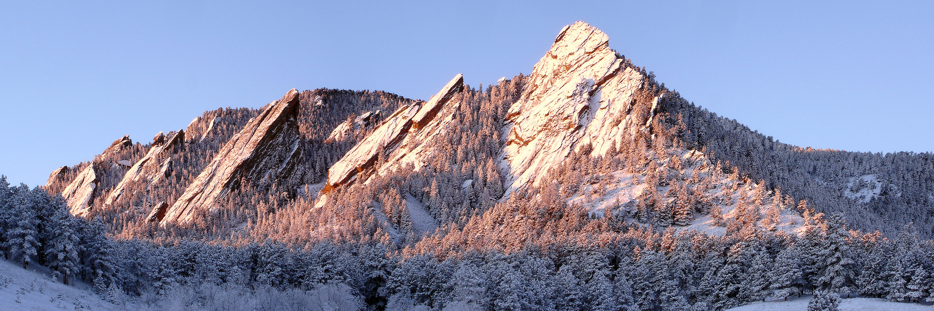
The Flatirons are rock formations in the western United States, near Boulder, Colorado, consisting of flatirons. There are five large, numbered Flatirons ranging from north to south (First through Fifth, respectively) along the east slope of Green Mountain (elev. ), and the term "The Flatirons" sometimes refers to these five alone. Numerous additional named Flatirons are on the southern part of Green Mountain, Bear Peak, and among the surrounding foothills. Etymology The Flatirons were known as the "Chautauqua Slabs" c. 1900 and "The Crags" c. 1906. There are two hypotheses regarding the origin of the current name, one based on resemblance to old-fashioned clothes irons, the other based on resemblance to the Flatiron Building completed in 1902. Geology The Flatirons consist of conglomeratic sandstone of the Fountain Formation. Geologists estimate the age of these rocks as 290 to 296 million years; they were lifted and tilted into their present orientation between 35 an ... [...More Info...] [...Related Items...] OR: [Wikipedia] [Google] [Baidu] |
Flatirons Winter Sunrise Edit 2
The Flatirons are rock formations in the western United States, near Boulder, Colorado, consisting of flatirons. There are five large, numbered Flatirons ranging from north to south (First through Fifth, respectively) along the east slope of Green Mountain (elev. ), and the term "The Flatirons" sometimes refers to these five alone. Numerous additional named Flatirons are on the southern part of Green Mountain, Bear Peak, and among the surrounding foothills. Etymology The Flatirons were known as the "Chautauqua Slabs" c. 1900 and "The Crags" c. 1906. There are two hypotheses regarding the origin of the current name, one based on resemblance to old-fashioned clothes irons, the other based on resemblance to the Flatiron Building completed in 1902. Geology The Flatirons consist of conglomeratic sandstone of the Fountain Formation. Geologists estimate the age of these rocks as 290 to 296 million years; they were lifted and tilted into their present orientation between 35 and ... [...More Info...] [...Related Items...] OR: [Wikipedia] [Google] [Baidu] |
Boulder, Colorado
Boulder is a home rule city that is the county seat and most populous municipality of Boulder County, Colorado, United States. The city population was 108,250 at the 2020 United States census, making it the 12th most populous city in Colorado. Boulder is the principal city of the Boulder, CO Metropolitan Statistical Area and an important part of the Front Range Urban Corridor. Boulder is located at the base of the foothills of the Rocky Mountains, at an elevation of above sea level. Boulder is northwest of the Colorado state capital of Denver. It is home of the main campus of the University of Colorado, the state's largest university. History On November 7, 1861, the Colorado General Assembly passed legislation to locate the University of Colorado in Boulder. On September 20, 1875, the first cornerstone was laid for the first building (Old Main) on the CU campus. The university officially opened on September 5, 1877. In 1907, Boulder adopted an anti- saloon ordi ... [...More Info...] [...Related Items...] OR: [Wikipedia] [Google] [Baidu] |
Flatiron (geomorphology)
Traditionally in geomorphology, a flatiron is a steeply sloping triangular landform created by the differential erosion of a steeply dipping, erosion-resistant layer of rock overlying softer strata. Flatirons have wide bases that form the base of a steep, triangular facet that narrows upward into a point at its summit. The dissection of a hogback by regularly spaced streams often results in the formation of a series of flatirons along the strike of the rock layer that formed the hogback.Ollier, C. D. (1985) ''Glossary of Morphotectonics,'' 2nd ed. Bureau of Mineral Resources. Geology and Geophysics Record no. 1985/30. Dept. of Geology and Geophysics, Canberra, Australia. 55 pp. Fairbridge, RW (1968) ''Hogback and Flatiron.'' In RW Fairbridge, ed., pp. 524-525, ''The Encyclopedia of Geomorphology'' (Encyclopedia of Earth Sciences, Volume III), Reinhold, New York, 1296 pp. Huggett, JL (2011) ''Fundamentals of Geomorphology.'' Routledge. New York, New York. 516 pp. As noted in s ... [...More Info...] [...Related Items...] OR: [Wikipedia] [Google] [Baidu] |
Fountain Formation
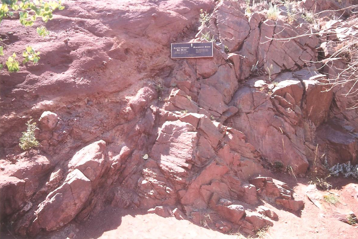
The Fountain Formation is a Pennsylvanian bedrock unit consisting primarily of conglomerate, sandstone, or arkose, in the states of Colorado and Wyoming in the United States, along the east side of the Front Range of the Rocky Mountains, and along the west edge of the Denver Basin. Origin of name The Fountain Formation was named by geologist W. C. Cross in 1894 for exposures along Fountain Creek in El Paso County, Colorado. Stratigraphy The Fountain Formation is found along the Front Range of Colorado. To the north, the Formation unconformably overlies Precambrian granite and gneiss. To the south, it overlies Mississippian, Ordovician and Devonian Limestones, as well as Cambrian sandstones. Outcrops of the formation typically dip steeply to the east. Depositional environment The formation was formed by the erosion of the Ancestral Rocky Mountains, and deposition by fluvial processes as alluvial fans. The characteristic predominant red color and the composition of the Fount ... [...More Info...] [...Related Items...] OR: [Wikipedia] [Google] [Baidu] |
Bear Peak (Boulder County, Colorado)
Bear Peak is a mountain summit in the Front Range of the Rocky Mountains of North America. The peak is located in Boulder Mountain Park, south-southwest ( bearing 206°) of downtown Boulder in Boulder County, Colorado, United States. Mountain Bear Peak is generally considered to be at the southern end of Boulder's Flatirons range, rock formations on the westernmost part of the city. The hike to the top of Bear Peak is a popular activity. In addition to hiking, Bear Peak has at least three rock climbing formations directly adjacent — The Slab, The Goose, and Seal Rock. These formations have rock climbs ranging from 5.2 (easy) to 5.13 (quite difficult). On June 26, 2012, the Flagstaff Fire erupted and burned an upper section of Bear Peak. Some homes in south Boulder were evacuated but no structures were lost in the blaze. The Flagstaff Fire was part of a busy 2012 fire season for Colorado. See also * List of Colorado mountain ranges * List of Colorado mountain summits ** ... [...More Info...] [...Related Items...] OR: [Wikipedia] [Google] [Baidu] |
Green Mountain (Boulder, Colorado)
Green Mountain is a mountain summit on the eastern flank of the Front Range of the Rocky Mountains of North America. The peak is located in Boulder Mountain Park, southwest by south ( bearing 219°) of downtown Boulder in Boulder County Boulder County is a county located in the U.S. state of Colorado of the United States. As of the 2020 census, the population was 330,758. The most populous municipality in the county and the county seat is Boulder. Boulder County comprises th ..., Colorado, United States. The mountain is renowned for the Flatirons rock formations on its eastern flank. Mountain See also * List of Colorado mountain ranges * List of Colorado mountain summits ** List of Colorado fourteeners ** List of Colorado 4000 meter prominent summits ** List of the most prominent summits of Colorado * List of Colorado county high points References External links Mountains of Colorado Mountains of Boulder County, Colorado North American 2000 m su ... [...More Info...] [...Related Items...] OR: [Wikipedia] [Google] [Baidu] |
Red Rocks Amphitheatre
Red Rocks Amphitheatre (also colloquially as simply Red Rocks) is an open-air amphitheatre built into a rock structure in the western United States, near Morrison, Colorado, west of Denver. There is a large, tilted, disc-shaped rock behind the stage, a huge vertical rock angled outwards from stage right, several large outcrops angled outwards from stage left and a seating area for up to 9,525. In 1927, the City of Denver purchased the area of Red Rocks; construction of the amphitheater began in 1936, and was opened to the public in June 1941.Red Rocks Park Timeline of the 1930s and 1940s, from Denvergov.org Since then, many notable performances and recordings for film and television have taken place there. In June 2015, the |
Morrison, Colorado
The Town of Morrison is a home rule municipality in Jefferson County, Colorado, United States. The population was 428 at the 2010 census. Red Rocks Amphitheatre is located nearby. History This small foothills settlement is named after George Morrison (April 16, 1822 – June 11, 1895), a builder and businessman who left a mark not only on the town that now bears his name, but on the history of the area. A stonemason who immigrated from Canada to the Mt. Vernon area in 1859, he helped found the town of Mt. Vernon and built the Mt. Vernon House, seat of the territorial government under Robert Steele, and an important stop for travelers on the Mt. Vernon Toll Road from Denver to the goldfields of the Rocky Mountains. He became a U.S. citizen on May 22, 1862.Brown, Georgina. 1976. ''Shining Mountains''. Library of Congress catalog # 75-41547, 248 p. (Index compiled by Ginna C. Snyder, Foothills Genealogical Society of Colorado, Inc., 1985.) George Morrison later moved south to Bea ... [...More Info...] [...Related Items...] OR: [Wikipedia] [Google] [Baidu] |
Douglas County, Colorado
Douglas County is a county located in the U.S. state of Colorado. As of the 2020 census, the population was 357,978. The county seat is Castle Rock. Douglas County is part of the Denver- Aurora- Lakewood, Colorado, metropolitan statistical area. It is located midway between Colorado's two largest cities, Denver and Colorado Springs, and contains a portion of Aurora, the state's third-largest city. Douglas County has the highest median household income of any Colorado county or statistical equivalent. It is ranked seventh nationally in that category. Overview Douglas County is lightly wooded, mostly with ponderosa pine, with broken terrain characterized by mesas, foothills, and small streams. Cherry Creek and Plum Creek rise in Douglas County and flow north toward Denver and into the South Platte River. Both were subject to flash flooding in the past, Plum Creek being partially responsible for the Denver flood of 1965. Cherry Creek and Plum Creek are now dammed. Mo ... [...More Info...] [...Related Items...] OR: [Wikipedia] [Google] [Baidu] |
Roxborough State Park
Roxborough State Park is a state park of Colorado, United States, known for dramatic red sandstone formations. Located in Douglas County south of Denver, Colorado, the park was established in 1975. In 1980 it was recognized as a National Natural Landmark. Geography Roxborough State Park, a Colorado State Park, is known for dramatic red sandstone formations. Located in Douglas County south of Denver, Colorado. In 1980 it was recognized as a National Natural Landmark because of the number of ecological systems and geological formations. It is also a State Historic Site and National Cultural District because of the number of archaeological sites. Climate According to the Köppen Climate Classification system, Roxborough State Park has an oceanic climate, abbreviated "Cfb" on climate maps. The hottest temperature recorded in Roxborough State Park was on July 17, 1997, and July 21, 1997, while the coldest temperature recorded was on February 2, 2011. Geology Roxboro ... [...More Info...] [...Related Items...] OR: [Wikipedia] [Google] [Baidu] |


