|
Fishing In The United States
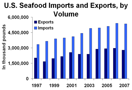
As with other countries, the exclusive economic zone (EEZ) off the coast of the United States gives its fishing industry special fishing rights. It covers 11.4 million square kilometres (4.38 million sq mi), which is the second largest zone in the world, exceeding the land area of the United States. According to the FAO, in 2005, the United States harvested 4,888,621 tonnes of fish from wild fisheries, and another 471,958 tonnes from aquaculture. This made the United States the fifth leading producer of fish, after China, Peru, India, and Indonesia, with 3.8 percent of the world total. Management Historically, fisheries developed in the U.S. as each area was settled. Concern for the sustainability of fishery resources was evident as early as 1871, when Congress wrote that "... the most valuable food fishes of the coast and the lakes of the U.S. are rapidly diminishing in number, to the public injury, and so as materially to affect the interests of trade and commerce..." Howe ... [...More Info...] [...Related Items...] OR: [Wikipedia] [Google] [Baidu] |
NOAA
The National Oceanic and Atmospheric Administration (abbreviated as NOAA ) is an United States scientific and regulatory agency within the United States Department of Commerce that forecasts weather, monitors oceanic and atmospheric conditions, charts the seas, conducts deep sea exploration, and manages fishing and protection of marine mammals and endangered species in the U.S. exclusive economic zone. Purpose and function NOAA's specific roles include: * ''Supplying Environmental Information Products''. NOAA supplies to its customers and partners information pertaining to the state of the oceans and the atmosphere, such as weather warnings and forecasts via the National Weather Service. NOAA's information services extend as well to climate, ecosystems, and commerce. * ''Providing Environmental Stewardship Services''. NOAA is a steward of U.S. coastal and marine environments. In coordination with federal, state, local, tribal and international authorities, NOAA manages the ... [...More Info...] [...Related Items...] OR: [Wikipedia] [Google] [Baidu] |
Bycatch
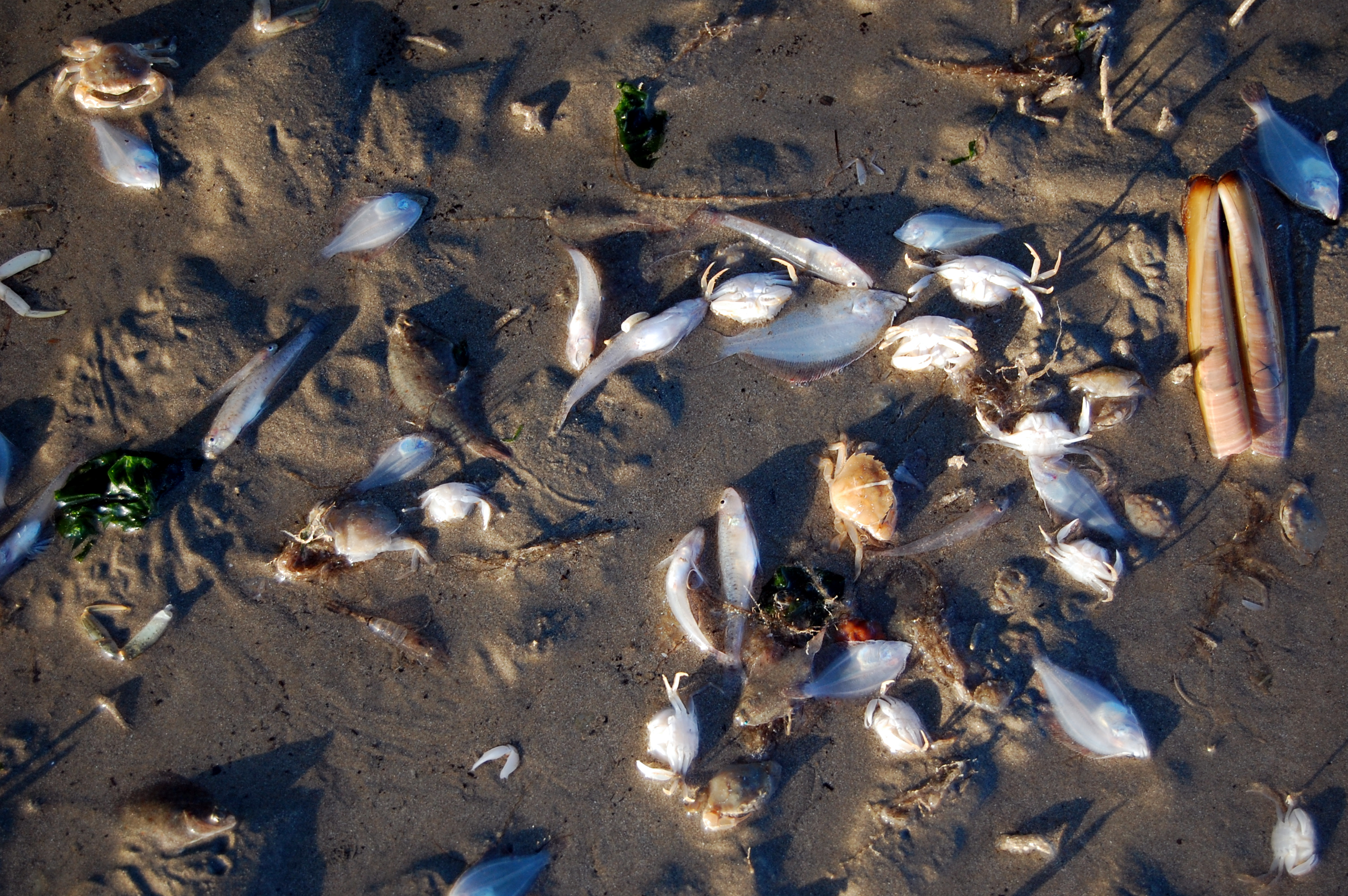
Bycatch (or by-catch), in the fishing industry, is a fish or other marine species that is caught unintentionally while fishing for specific species or sizes of wildlife. Bycatch is either the wrong species, the wrong sex, or is undersized or juveniles of the target species. The term "bycatch" is also sometimes used for untargeted catch in other forms of animal harvesting or collecting. Non- marine species (freshwater fish not saltwater fish) that are caught (either intentionally or unintentionally) but regarded as generally "undesirable" are referred to as "rough fish" (mainly US) and " coarse fish" (mainly UK). In 1997, the Organisation for Economic Co-operation and Development (OECD) defined bycatch as "total fishing mortality, excluding that accounted directly by the retained catch of target species". Bycatch contributes to fishery decline and is a mechanism of overfishing for unintentional catch. The average annual bycatch rate of pinnipeds and cetaceans in the US from 199 ... [...More Info...] [...Related Items...] OR: [Wikipedia] [Google] [Baidu] |
Bering Sea
The Bering Sea (, ; rus, Бе́рингово мо́ре, r=Béringovo móre) is a marginal sea of the Northern Pacific Ocean. It forms, along with the Bering Strait, the divide between the two largest landmasses on Earth: Eurasia and The Americas. It comprises a deep water basin, which then rises through a narrow slope into the shallower water above the continental shelf, continental shelves. The Bering Sea is named for Vitus Bering, a Denmark, Danish navigator in Russian service, who, in 1728, was the first European to systematically explore it, sailing from the Pacific Ocean northward to the Arctic Ocean. The Bering Sea is separated from the Gulf of Alaska by the Alaska Peninsula. It covers over and is bordered on the east and northeast by Alaska, on the west by the Russian Far East and the Kamchatka Peninsula, on the south by the Alaska Peninsula and the Aleutian Islands and on the far north by the Bering Strait, which connects the Bering Sea to the Arctic Ocean's Chukchi ... [...More Info...] [...Related Items...] OR: [Wikipedia] [Google] [Baidu] |
Gulf Of Alaska
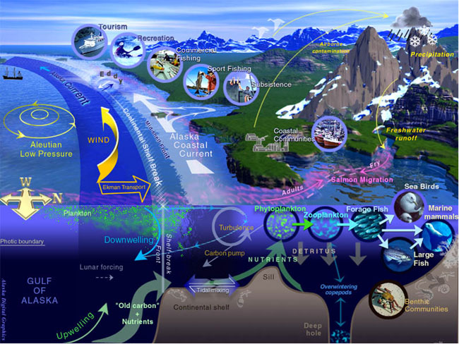
The Gulf of Alaska (Tlingit: ''Yéil T'ooch’'') is an arm of the Pacific Ocean defined by the curve of the southern coast of Alaska, stretching from the Alaska Peninsula and Kodiak Island in the west to the Alexander Archipelago in the east, where Glacier Bay and the Inside Passage are found. The Gulf shoreline is a combination of forest, mountain and a number of tidewater glaciers. Alaska's largest glaciers, the Malaspina Glacier and Bering Glacier, spill out onto the coastal line along the Gulf of Alaska. The coast is heavily indented with Cook Inlet and Prince William Sound, the two largest connected bodies of water. It includes Yakutat Bay and Cross Sound. Lituya Bay (a fjord north of Cross Sound, and south of Mount Fairweather) is the site of the largest recorded tsunami in history. It serves as a sheltered anchorage for fishing boats. Ecology The Gulf of Alaska is considered a Class I, productive ecosystem with more than 300 grams of carbon per square meter per year ... [...More Info...] [...Related Items...] OR: [Wikipedia] [Google] [Baidu] |
Hawaii
Hawaii ( ; haw, Hawaii or ) is a state in the Western United States, located in the Pacific Ocean about from the U.S. mainland. It is the only U.S. state outside North America, the only state that is an archipelago, and the only state geographically located within the tropics. Hawaii comprises nearly the entire Hawaiian archipelago, 137 volcanic islands spanning that are physiographically and ethnologically part of the Polynesian subregion of Oceania. The state's ocean coastline is consequently the fourth-longest in the U.S., at about . The eight main islands, from northwest to southeast, are Niihau, Kauai, Oahu, Molokai, Lānai, Kahoolawe, Maui, and Hawaii—the last of these, after which the state is named, is often called the "Big Island" or "Hawaii Island" to avoid confusion with the state or archipelago. The uninhabited Northwestern Hawaiian Islands make up most of the Papahānaumokuākea Marine National Monument, the United States' largest protected ... [...More Info...] [...Related Items...] OR: [Wikipedia] [Google] [Baidu] |
Insular Area
In the law of the United States, an insular area is a U.S.-associated jurisdiction that is not part of the 50 states or the District of Columbia. This includes fourteen U.S. territories administered under U.S. sovereignty, as well as three sovereign states each with a Compact of Free Association with the United States. The term also may be used to refer to the previous status of the Philippine Islands and the Trust Territory of the Pacific Islands when it existed. Three of the U.S. territories are in the Caribbean Sea, eleven are in the Pacific Ocean, and all three freely associated states are also in the Pacific. Two additional Caribbean territories are disputed and administered by Colombia. Article IV, Section 3, Clause 2 of the U.S. Constitution grants to the United States Congress the responsibility of overseeing the territories. A series of U.S. Supreme Court decisions known as the Insular Cases created a distinction between "incorporated territories", where the full Con ... [...More Info...] [...Related Items...] OR: [Wikipedia] [Google] [Baidu] |
California Current
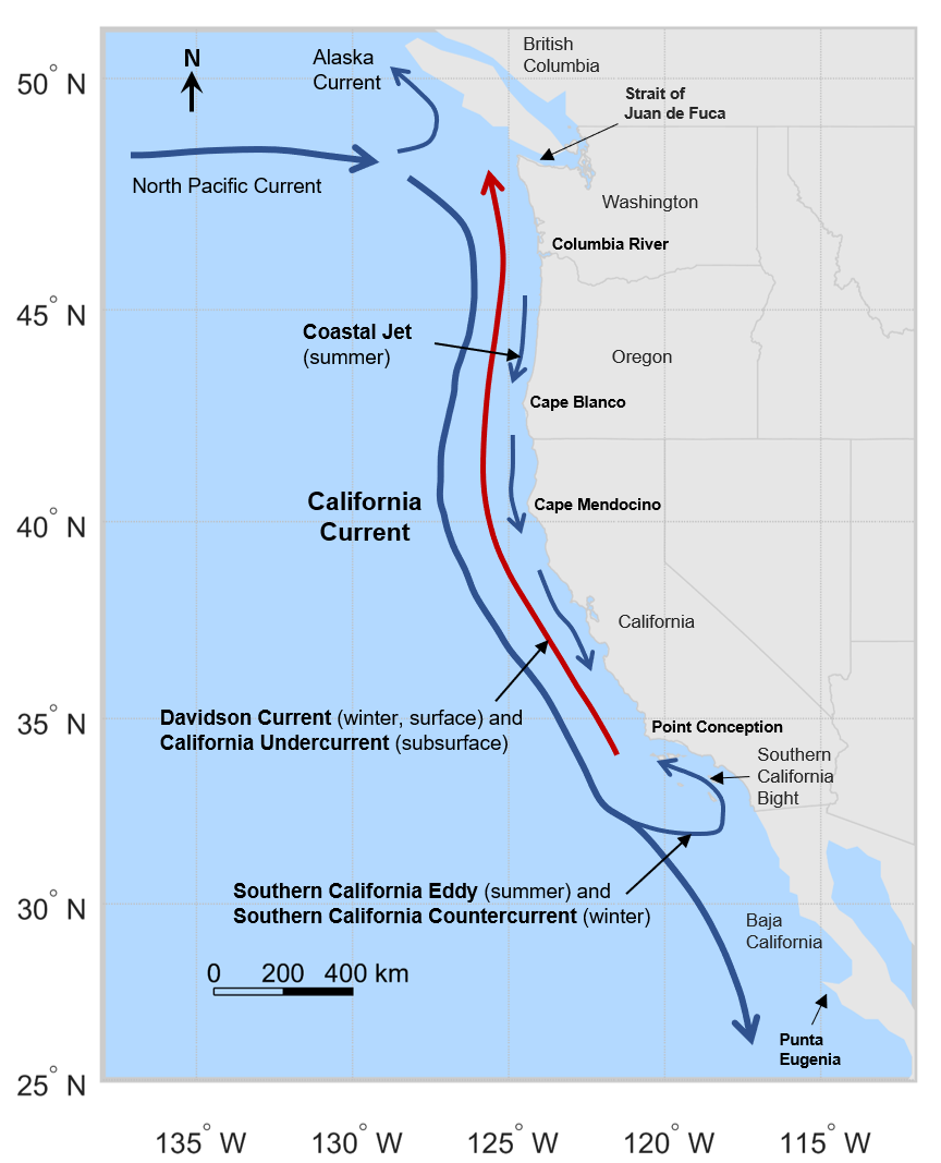
The California Current is a cold water Pacific Ocean current that moves southward along the western coast of North America, beginning off southern British Columbia and ending off southern Baja California Sur. It is considered an Eastern boundary current due to the influence of the North American coastline on its course. It is also one of five major coastal currents affiliated with strong upwelling zones, the others being the Humboldt Current, the Canary Current, the Benguela Current, and the Somali Current. The California Current is part of the North Pacific Gyre, a large swirling current that occupies the northern basin of the Pacific. Physical properties The movement of Alaskan and northern ocean currents southward down the west coast results in much cooler ocean temperatures than at comparable latitudes on the east coast of the United States, where ocean currents come from the Caribbean and tropical Atlantic. The cooler ocean current along the west coast also makes summer ... [...More Info...] [...Related Items...] OR: [Wikipedia] [Google] [Baidu] |
Gulf Of Mexico
The Gulf of Mexico ( es, Golfo de México) is an oceanic basin, ocean basin and a marginal sea of the Atlantic Ocean, largely surrounded by the North American continent. It is bounded on the northeast, north and northwest by the Gulf Coast of the United States; on the southwest and south by the Mexico, Mexican States of Mexico, states of Tamaulipas, Veracruz, Tabasco, Campeche, Yucatan, and Quintana Roo; and on the southeast by Cuba. The Southern United States, Southern U.S. states of Texas, Louisiana, Mississippi, Alabama, and Florida, which border the Gulf on the north, are often referred to as the "Third Coast" of the United States (in addition to its Atlantic and Pacific Ocean, Pacific coasts). The Gulf of Mexico took shape approximately 300 million years ago as a result of plate tectonics.Huerta, A.D., and D.L. Harry (2012) ''Wilson cycles, tectonic inheritance, and rifting of the North American Gulf of Mexico continental margin.'' Geosphere. 8(1):GES00725.1, first p ... [...More Info...] [...Related Items...] OR: [Wikipedia] [Google] [Baidu] |
Caribbean Sea
The Caribbean Sea ( es, Mar Caribe; french: Mer des Caraïbes; ht, Lanmè Karayib; jam, Kiaribiyan Sii; nl, Caraïbische Zee; pap, Laman Karibe) is a sea of the Atlantic Ocean in the tropics of the Western Hemisphere. It is bounded by Mexico and Central America to the west and southwest, to the north by the Greater Antilles starting with Cuba, to the east by the Lesser Antilles, and to the south by the northern coast of South America. The Gulf of Mexico lies to the northwest. The entire area of the Caribbean Sea, the numerous islands of the West Indies, and adjacent coasts are collectively known as the Caribbean. The Caribbean Sea is one of the largest seas and has an area of about . The sea's deepest point is the Cayman Trough, between the Cayman Islands and Jamaica, at below sea level. The Caribbean coastline has many gulfs and bays: the Gulf of Gonâve, Gulf of Venezuela, Gulf of Darién, Golfo de los Mosquitos, Gulf of Paria and Gulf of Honduras. The Caribbean Sea has ... [...More Info...] [...Related Items...] OR: [Wikipedia] [Google] [Baidu] |
Large Marine Ecosystem
Large marine ecosystems (LMEs) are regions of the world's oceans, encompassing coastal areas from river basins and estuaries to the seaward boundaries of continental shelves and the outer margins of the major ocean current systems. They are relatively large regions on the order of 200,000 km² or greater, characterized by distinct bathymetry, hydrography, productivity, and trophically dependent populations. Productivity in LME protected areas is generally higher than in the open ocean. The system of LMEs has been developed by the US National Oceanic and Atmospheric Administration (NOAA) to identify areas of the oceans for conservation purposes. The objective is to use the LME concept as a tool for enabling ecosystem-based management to provide a collaborative approach to management of resources within ecologically-bounded transnational areas. This will be done in an international context and consistent with customary international law as reflected in 1982 UN Convention on t ... [...More Info...] [...Related Items...] OR: [Wikipedia] [Google] [Baidu] |
Territorial Waters - United States
A territory is an area of land, sea, or space, particularly belonging or connected to a country, person, or animal. In international politics, a territory is usually either the total area from which a state may extract power resources or an administrative division is usually an area that is under the jurisdiction of a sovereign state. As a subdivision a territory is in most countries an organized division of an area that is controlled by a country but is not formally developed into, or incorporated into, a political unit of the country that is of equal status to other political units that may often be referred to by words such as "provinces" or "regions" or "states". In its narrower sense, it is "a geographic region, such as a colonial possession, that is dependent on an external government." Etymology The origins of the word "territory" begin with the Proto-Indo-European root ''ters'' ('to dry'). From this emerged the Latin word ''terra'' ('earth, land') and later the La ... [...More Info...] [...Related Items...] OR: [Wikipedia] [Google] [Baidu] |
Ecosystem Based Fishery
The goal of fisheries management is to produce sustainable biological, environmental and socioeconomic benefits from renewable aquatic resources. Wild fisheries are classified as renewable when the organisms of interest (e.g., fish, shellfish, amphibians, reptiles and marine mammals) produce an annual biological surplus that with judicious management can be harvested without reducing future productivity. Fishery management employs activities that protect fishery resources so sustainable exploitation is possible, drawing on fisheries science and possibly including the precautionary principle. Modern fisheries management is often referred to as a governmental system of appropriate environmental management rules based on defined objectives and a mix of management means to implement the rules, which are put in place by a system of monitoring control and surveillance. A popular approach is the ecosystem approach to fisheries management. According to the Food and Agriculture Organiz ... [...More Info...] [...Related Items...] OR: [Wikipedia] [Google] [Baidu] |


